Bridge Statistics for Akron, Pennsylvania (PA)
Condition, Traffic, Stress, Structural Evaluation, Project Costs
- National Bridge Inventory (NBI) Statistics
- 14Number of bridges
- 72ft / 21.8mTotal length
- $323,000Total costs
- 110,607Total average daily traffic
- 17,266Total average daily truck traffic
- National Bridge Inventory (NBI) Registered Bridges for Akron
- No street view available for this location
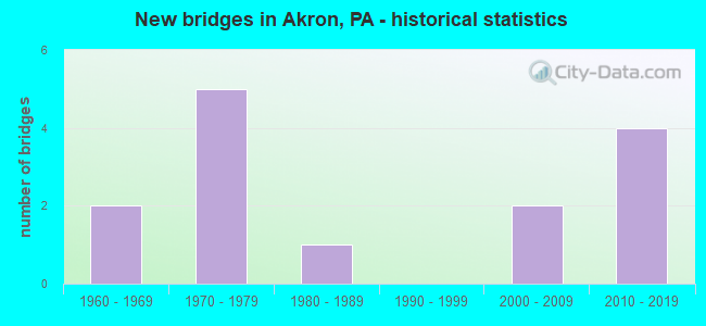
- New bridges - historical statistics
- 21960-1969
- 51970-1979
- 11980-1989
- 22000-2009
- 42010-2019

- Reconstructed bridges - Historical Statistics
- 11990-1999
- 12000-2009


- Bridge Condition - Deck
- 83.3%Good
- 16.7%Fair

- Bridge Condition - Superstructure
- 28.6%Very good
- 42.9%Good
- 28.6%Satisfactory

- Bridge Condition - Substructure
- 28.6%Very good
- 57.1%Good
- 14.3%Satisfactory

- Bridge Condition - Channel
- 12.5%Good
- 37.5%Satisfactory
- 50.0%Fair

- Bridge Condition - Culverts
- 33.3%Very good
- 66.7%Good
Find on map >> Show street view
Structure Number: 5378, Location: 5.5 MI SO. OF RT 22 & 183 (Lat: 40.419836, Lng: -76.177108), Route carried "on" structure: City street , Year Built: 1960, Year Reconstructed: 1995, Status: Posted for load, Structure Length: 0.91m (2.99ft), Average Daily Traffic: 70 (year 2010), Average Future Daily Traffic: 80 (year 2020), Design Load: H 10, Features Intersected: MILL CREEK, Facility Carried by Structure: CROSS KEY ROAD
Minimum Vertical Clearance: 30+ m (98+ ft), Kilometerpoint: 0.000, Lanes on structure: 2, Owner: Town or Township Highway Agency, Approaching Roadway Width: 4.9m (16.1ft), Material/Design: Steel, Design/Construction: Stringer/Multi-beam, Number Of Spans In Main Unit: 1, Length of Maximum Span: 7.6m (24.9ft), Curb-To-Curb Width: 6.8m (22.3ft), Out-to-Out Width: 7.2m (23.6ft)
Condition: Deck: Fair, Superstructure: Satisfactory, Substructure: Satisfactory, Channel: Fair, Operating Rating: 22.7 metric tons, Method Used To Determine Operating Rating: Load Factor (LF), Inventory Rating: 13.6 metric tons, Method Used To Determine Inventory Rating: Load Factor (LF), Structural Evaluation: Meets minimum limits, Deck Geometry: Somewhat better than minimum adequacy, Waterway Adequacy: Better than present minimum criteria, Approach Roadway Alignment: Equal to present desirable criteria, Bridge Posting: Required (Relationship of Operating Rating to Maximum Legal Load: > 39.9% below), Length Of Structure Improvement: 1.60m (5.25ft), Designated Inspection Frequency: Every 24 months, Other Special Inspection Frequency: Every 12 months, Inspection Date: July 2020, Other Special Inspection Date: July 2021, Deck Structure Type: Concrete Cast-file-Place, Wearing Surface/Protective System: Wearing Surface: Bituminous, Membrane: Preformed Fabric
Find on map >> Show street view
Structure Number: 21098, Location: DIAMOND SPRINGS-W EARL TP (Lat: 40.150000, Lng: -76.176667), Route carried "on" structure: State highway , Year Built: 1970, Status: Open, Structure Length: 8.50m (27.89ft), Average Daily Traffic: 52 (year 2022), Truck Traffic: 5%, Average Future Daily Traffic: 56 (year 2032), Design Load: HS 20, Features Intersected: 222, Facility Carried by Structure: 1074;T662 Miley
Minimum Vertical Clearance: 30+ m (98+ ft), Kilometerpoint: 0.000, Lanes on structure: 2, Lanes under structure: 4, Owner: State Highway Agency, Approaching Roadway Width: 6.1m (20.0ft), Skew: 2 degrees, Material/Design: Prestressed concrete, Design/Construction: Stringer/Multi-beam, Number Of Spans In Main Unit: 4, Length of Maximum Span: 28.0m (91.9ft), Curb or Sidewalk Widths: Left: 0.2m (0.7ft), Right: 0.2m (0.7ft), Curb-To-Curb Width: 11.0m (36.1ft), Out-to-Out Width: 12.2m (40.0ft)
Condition: Deck: Good, Superstructure: Satisfactory, Substructure: Good, Operating Rating: 71.7 metric tons, Method Used To Determine Operating Rating: Load Factor (LF), Inventory Rating: 29.0 metric tons, Method Used To Determine Inventory Rating: Load Factor (LF), Structural Evaluation: Equal to present minimum criteria, Deck Geometry: Superior to present desirable criteria, Underclear: Equal to present minimum criteria, Approach Roadway Alignment: Equal to present desirable criteria, Length Of Structure Improvement: 9.40m (30.84ft), Designated Inspection Frequency: Every 24 months, Inspection Date: August 2020, Deck Structure Type: Concrete Cast-file-Place, Wearing Surface/Protective System: Wearing Surface: Monolithic Concrete
Find on map >> Show street view
Structure Number: 22651, Location: .5 MI.S.W. OF LICKDALE (Lat: 40.435319, Lng: -76.518439), Route carried "on" structure: Interstate 81, Year Built: 1967, Year Reconstructed: 2005, Status: Open, Structure Length: 1.28m (4.20ft), Average Daily Traffic: 13,183 (year 2021), Truck Traffic: 32%, Average Future Daily Traffic: 14,795 (year 2032), Design Load: HL 93, Features Intersected: BORDNERSVILLE RD; T-446
Minimum Vertical Clearance: 30+ m (98+ ft), Kilometerpoint: 12.059, Lanes on structure: 2, Lanes under structure: 2, Base Highway Network: Yes, Owner: State Highway Agency, Approaching Roadway Width: 13.7m (44.9ft), Skew: 14 degrees, Material/Design: Prestressed concrete, Design/Construction: Box Beam or Girders - Single/Spread, Number Of Spans In Main Unit: 1, Length of Maximum Span: 12.5m (41.0ft), Curb or Sidewalk Widths: Left: 0.2m (0.7ft), Right: 0.2m (0.7ft), Curb-To-Curb Width: 13.7m (44.9ft), Out-to-Out Width: 14.8m (48.6ft)
Condition: Deck: Good, Superstructure: Good, Substructure: Good, Operating Rating: 77.1 metric tons, Method Used To Determine Operating Rating: Load and Resistance Factor (LRFR), Inventory Rating: 56.2 metric tons, Method Used To Determine Inventory Rating: Load and Resistance Factor (LRFR), Structural Evaluation: Better than present minimum criteria, Deck Geometry: Superior to present desirable criteria, Underclear: Somewhat better than minimum adequacy, Approach Roadway Alignment: Equal to present desirable criteria, Length Of Structure Improvement: 1.90m (6.23ft), Designated Inspection Frequency: Every 24 months, Inspection Date: October 2019, Bridge Improvement Cost: $6,000, Roadway Improvement Cost: $17,000, Total Project Cost: $79,000, Deck Structure Type: Concrete Cast-file-Place, Wearing Surface/Protective System: Wearing Surface: Monolithic Concrete, Deck Protection: Epoxy Coated Reinforcing
Find on map >> Show street view
Structure Number: 32536, Location: GIBSON TWP 593' E TR 92 (Lat: 41.789669, Lng: -75.586042), Route carried "on" structure: State highway , Year Built: 1980, Status: Open, Structure Length: 1.19m (3.90ft), Average Daily Traffic: 96 (year 2022), Truck Traffic: 8%, Average Future Daily Traffic: 82 (year 2032), Design Load: HS 20, Features Intersected: TUNKHANNOCK CREEK, Facility Carried by Structure: SR 2036
Minimum Vertical Clearance: 30+ m (98+ ft), Kilometerpoint: 0.000, Lanes on structure: 2, Owner: State Highway Agency, Approaching Roadway Width: 4.9m (16.1ft), Material/Design: Prestressed concrete, Design/Construction: Box Beam or Girders - Multiple, Number Of Spans In Main Unit: 1, Length of Maximum Span: 11.6m (38.1ft), Curb or Sidewalk Widths: Left: 0.2m (0.7ft), Right: 0.2m (0.7ft), Curb-To-Curb Width: 8.6m (28.2ft), Out-to-Out Width: 9.6m (31.5ft)
Condition: Deck: Good, Superstructure: Good, Substructure: Good, Channel: Satisfactory, Operating Rating: 80.7 metric tons, Method Used To Determine Operating Rating: Load Factor (LF), Inventory Rating: 39.9 metric tons, Method Used To Determine Inventory Rating: Load Factor (LF), Structural Evaluation: Better than present minimum criteria, Deck Geometry: Better than present minimum criteria, Waterway Adequacy: Better than present minimum criteria, Approach Roadway Alignment: Equal to present desirable criteria, Length Of Structure Improvement: 1.20m (3.94ft), Designated Inspection Frequency: Every 24 months, Inspection Date: April 2020, Deck Structure Type: Concrete Cast-file-Place, Wearing Surface/Protective System: Wearing Surface: Monolithic Concrete, Deck Protection: Epoxy Coated Reinforcing
Find on map >> Show street view
Structure Number: 42975, Location: 1/2 MI NW OF SR 1018 (Lat: 40.169456, Lng: -76.220667), Route carried "on" structure: City street 648, Year Built: 2005, Status: Open, Structure Length: 2.07m (6.79ft), Average Daily Traffic: 680 (year 2012), Truck Traffic: 10%, Average Future Daily Traffic: 910 (year 2032), Design Load: HS 25 or greater, Features Intersected: COCALICO CREEK, Facility Carried by Structure: ROYER RD
Minimum Vertical Clearance: 30+ m (98+ ft), Kilometerpoint: 0.000, Lanes on structure: 2, Toll: Toll bridge, Owner: County Highway Agency, Approaching Roadway Width: 6.1m (20.0ft), Material/Design: Concrete, Design/Construction: Arch - Deck, Number Of Spans In Main Unit: 2, Length of Maximum Span: 9.8m (32.2ft), Curb-To-Curb Width: 8.5m (27.9ft), Out-to-Out Width: 9.6m (31.5ft)
Condition: Superstructure: Very good, Substructure: Very good, Channel: Good, Inventory Rating: 65.3 metric tons, Method Used To Determine Inventory Rating: Load Factor (LF), Structural Evaluation: Equal to present desirable criteria, Deck Geometry: Somewhat better than minimum adequacy, Waterway Adequacy: Equal to present desirable criteria, Approach Roadway Alignment: Equal to present desirable criteria, Length Of Structure Improvement: 1.80m (5.91ft), Designated Inspection Frequency: Every 24 months, Inspection Date: October 2020, Bridge Improvement Cost: $18,000, Roadway Improvement Cost: $53,000, Total Project Cost: $244,000
Find on map >> Show street view
Structure Number: 57019, Location: Sugarloaf Township (Lat: 41.007831, Lng: -76.101331), Route carried "on" structure: Other road , Year Built: 2015, Status: Open, Structure Length: 4.63m (15.19ft), Average Daily Traffic: 750 (year 2020), Truck Traffic: 3%, Average Future Daily Traffic: 900 (year 2030), Design Load: HL 93, Features Intersected: Nescopeck Creek, Facility Carried by Structure: Mill Hill Road
Minimum Vertical Clearance: 30+ m (98+ ft), Kilometerpoint: 0.000, Lanes on structure: 2, Owner: County Highway Agency, Maintenance Responsibility: Town or Township Highway Agency, Approaching Roadway Width: 6.7m (22.0ft), Skew: 1 degrees, Material/Design: Concrete continuous, Design/Construction: Box Beam or Girders - Single/Spread, Number Of Spans In Main Unit: 2, Length of Maximum Span: 22.6m (74.1ft), Curb-To-Curb Width: 6.7m (22.0ft), Out-to-Out Width: 7.8m (25.6ft)
Condition: Deck: Good, Superstructure: Very good, Substructure: Very good, Channel: Satisfactory, Operating Rating: 53.5 metric tons, Method Used To Determine Operating Rating: Assigned ratings based on Load and Resistance Factor Design (LRFD) reported by rating factor (RF) using HL93 loadings, Inventory Rating: 33.4 metric tons, Method Used To Determine Inventory Rating: Assigned ratings based on Load and Resistance Factor Design (LRFD) reported by rating factor (RF) using HL93 loadings, Structural Evaluation: Equal to present desirable criteria, Deck Geometry: Meets minimum limits, Waterway Adequacy: Equal to present desirable criteria, Approach Roadway Alignment: Equal to present minimum criteria, Designated Inspection Frequency: Every 24 months, Inspection Date: October 2020, Deck Structure Type: Concrete Cast-file-Place, Wearing Surface/Protective System: Wearing Surface: Monolithic Concrete, Deck Protection: Epoxy Coated Reinforcing
Find on map >> Show street view
Structure Number: 57025, Location: FRANKLIN TOWNSHIP (Lat: 39.970928, Lng: -79.715111), Route carried "on" structure: State highway , Year Built: 2019, Status: Open, Structure Length: 0.85m (2.79ft), Average Daily Traffic: 650 (year 2020), Truck Traffic: 18%, Average Future Daily Traffic: 1,000 (year 2041), Design Load: HL 93, Features Intersected: Bute Run, Facility Carried by Structure: SR 4010
Minimum Vertical Clearance: 30+ m (98+ ft), Kilometerpoint: 13.953, Lanes on structure: 2, Owner: State Highway Agency, Approaching Roadway Width: 10.1m (33.1ft), Skew: 3 degrees, Material/Design: Concrete, Design/Construction: Culvert, Number Of Spans In Main Unit: 1, Length of Maximum Span: 8.2m (26.9ft), Curb-To-Curb Width: 9.9m (32.5ft), Out-to-Out Width: 16.5m (54.1ft)
Condition: Channel: Satisfactory, Culverts: Very good, Operating Rating: 57.3 metric tons, Method Used To Determine Operating Rating: Assigned ratings based on Load and Resistance Factor Design (LRFD) reported by rating factor (RF) using HL93 loadings, Inventory Rating: 36.3 metric tons, Method Used To Determine Inventory Rating: Assigned ratings based on Load and Resistance Factor Design (LRFD) reported by rating factor (RF) using HL93 loadings, Structural Evaluation: Equal to present desirable criteria, Deck Geometry: Equal to present minimum criteria, Waterway Adequacy: Equal to present desirable criteria, Approach Roadway Alignment: Equal to present desirable criteria, Designated Inspection Frequency: Every 24 months, Inspection Date: March 2021
Find on map >> Show street view
Structure Number: 57631, Location: TR635 WHITELEIGH RD/S BRA (Lat: 41.819336, Lng: -75.232800), Route carried "on" structure: City street , Year Built: 2013, Status: Open, Structure Length: 0.73m (2.40ft), Average Daily Traffic: 10 (year 2020), Average Future Daily Traffic: 20 (year 2040), Features Intersected: SOUTH BRANCH EQUINUNK CR, Facility Carried by Structure: TR635 WHITELIGH RO
Minimum Vertical Clearance: 30+ m (98+ ft), Kilometerpoint: 0.000, Lanes on structure: 1, Owner: Town or Township Highway Agency, Approaching Roadway Width: 4.0m (13.1ft), Skew: 9 degrees, Material/Design: Concrete, Design/Construction: Culvert, Number Of Spans In Main Unit: 1, Length of Maximum Span: 7.3m (24.0ft), Curb-To-Curb Width: 4.0m (13.1ft), Out-to-Out Width: 5.1m (16.7ft)
Condition: Channel: Fair, Culverts: Good, Operating Rating: 86.2 metric tons, Method Used To Determine Operating Rating: Field evaluation and documented engineering judgment, Inventory Rating: 51.7 metric tons, Method Used To Determine Inventory Rating: Field evaluation and documented engineering judgment, Structural Evaluation: Better than present minimum criteria, Deck Geometry: Somewhat better than minimum adequacy, Waterway Adequacy: Better than present minimum criteria, Approach Roadway Alignment: Equal to present desirable criteria, Designated Inspection Frequency: Every 24 months, Inspection Date: September 2020
Find on map >> Show street view
Structure Number: 57632, Location: 900 FT NW of BRAMAN ROAD (Lat: 41.819175, Lng: -75.164233), Route carried "on" structure: City street , Year Built: 2003, Status: Posted for load, Structure Length: 0.79m (2.59ft), Average Daily Traffic: 15 (year 2020), Average Future Daily Traffic: 30 (year 2040), Features Intersected: SALT RIVER BROOK, Facility Carried by Structure: TR639 TEEPLE ROAD
Minimum Vertical Clearance: 30+ m (98+ ft), Kilometerpoint: 0.000, Lanes on structure: 2, Owner: Town or Township Highway Agency, Approaching Roadway Width: 4.9m (16.1ft), Skew: 5 degrees, Material/Design: Steel, Design/Construction: Stringer/Multi-beam, Number Of Spans In Main Unit: 1, Length of Maximum Span: 7.6m (24.9ft), Curb-To-Curb Width: 5.5m (18.0ft), Out-to-Out Width: 6.1m (20.0ft)
Condition: Deck: Good, Superstructure: Good, Substructure: Good, Channel: Fair, Operating Rating: 38.1 metric tons, Method Used To Determine Operating Rating: Load Factor (LF), Inventory Rating: 22.7 metric tons, Method Used To Determine Inventory Rating: Load Factor (LF), Structural Evaluation: Equal to present minimum criteria, Deck Geometry: Meets minimum limits, Waterway Adequacy: Better than present minimum criteria, Approach Roadway Alignment: Equal to present desirable criteria, Bridge Posting: Required (Relationship of Operating Rating to Maximum Legal Load: 20.0 - 29.9% below), Designated Inspection Frequency: Every 24 months, Other Special Inspection Frequency: Every 12 months, Inspection Date: September 2020
Find on map >> Show street view
Structure Number: 57633, Location: .85M W SR 0247, CHINAMANS (Lat: 41.819422, Lng: -75.361436), Route carried "on" structure: City street , Year Built: 2013, Status: Open, Structure Length: 0.82m (2.69ft), Average Daily Traffic: 15 (year 2020), Average Future Daily Traffic: 30 (year 2040), Design Load: HS 25 or greater, Features Intersected: EQUINONK CREEK, Facility Carried by Structure: TR682 CHINAMANS RO
Minimum Vertical Clearance: 30+ m (98+ ft), Kilometerpoint: 0.000, Lanes on structure: 2, Owner: Town or Township Highway Agency, Approaching Roadway Width: 4.9m (16.1ft), Skew: 9 degrees, Material/Design: Concrete, Design/Construction: Culvert, Number Of Spans In Main Unit: 1, Length of Maximum Span: 0.3m (1.0ft), Curb-To-Curb Width: 5.5m (18.0ft), Out-to-Out Width: 6.7m (22.0ft)
Condition: Channel: Fair, Culverts: Good, Operating Rating: 80.7 metric tons, Method Used To Determine Operating Rating: Field evaluation and documented engineering judgment, Inventory Rating: 48.1 metric tons, Method Used To Determine Inventory Rating: Field evaluation and documented engineering judgment, Structural Evaluation: Better than present minimum criteria, Deck Geometry: Meets minimum limits, Waterway Adequacy: Better than present minimum criteria, Approach Roadway Alignment: Equal to present desirable criteria, Designated Inspection Frequency: Every 24 months, Inspection Date: September 2020
Find on map >> Show street view
Structure Number: 21098, Location: DIAMOND SPRINGS-W EARL TP (Lat: 40.150000, Lng: -76.176667), Route carried "under" structure: US 222, Year Built: 1970, Structure Length: 0. m, Average Daily Traffic: 23,601 (year 2020), Truck Traffic: 14%, Features Intersected: 222, Facility Carried by Structure: 1074;T662 Miley
Minimum Vertical Clearance: 4.57m (14.99ft), Kilometerpoint: 61.908, Lanes on structure: 2, Lanes under structure: 2, Material/Design: Prestressed concrete, Design/Construction: Stringer/Multi-beam, Length of Maximum Span: 28.0m (91.9ft)
Find on map >> Show street view
Structure Number: 21098, Location: DIAMOND SPRINGS-W EARL TP (Lat: 40.150000, Lng: -76.176667), Route carried "under" structure: US 222, Year Built: 1970, Structure Length: 0. m, Average Daily Traffic: 23,942 (year 2020), Truck Traffic: 13%, Features Intersected: 222, Facility Carried by Structure: 1074;T662 Miley
Minimum Vertical Clearance: 5.00m (16.40ft), Kilometerpoint: 61.886, Lanes on structure: 2, Lanes under structure: 2, Material/Design: Prestressed concrete, Design/Construction: Stringer/Multi-beam, Length of Maximum Span: 28.0m (91.9ft)
Find on map >> Show street view
Structure Number: 21418, Location: 0.25 MI.S. DIAMOND SPRING (Lat: 40.146844, Lng: -76.184803), Route carried "under" structure: US 222, Year Built: 1970, Structure Length: 0. m, Average Daily Traffic: 23,942 (year 2020), Truck Traffic: 13%, Features Intersected: US 222; SR 0222, Facility Carried by Structure: 1025 Farmersville
Minimum Vertical Clearance: 4.88m (16.01ft), Kilometerpoint: 61.886, Lanes on structure: 2, Lanes under structure: 4, Material/Design: Prestressed concrete, Design/Construction: Stringer/Multi-beam, Length of Maximum Span: 26.2m (86.0ft)
Find on map >> Show street view
Structure Number: 21418, Location: 0.25 MI.S. DIAMOND SPRING (Lat: 40.146844, Lng: -76.184803), Route carried "under" structure: US 222, Year Built: 1970, Structure Length: 0. m, Average Daily Traffic: 23,601 (year 2020), Truck Traffic: 14%, Features Intersected: US 222; SR 0222, Facility Carried by Structure: 1025 Farmersville
Minimum Vertical Clearance: 4.62m (15.16ft), Kilometerpoint: 61.908, Lanes on structure: 2, Lanes under structure: 4, Material/Design: Prestressed concrete, Design/Construction: Stringer/Multi-beam, Length of Maximum Span: 26.2m (86.0ft)