Bridge Statistics for Akron, Michigan (MI)
Condition, Traffic, Stress, Structural Evaluation, Project Costs
- National Bridge Inventory (NBI) Statistics
- 14Number of bridges
- 46ft / 14.2mTotal length
- $290,000Total costs
- 8,195Total average daily traffic
- 326Total average daily truck traffic
- 12,116Total future (year 2018) average daily traffic
- National Bridge Inventory (NBI) Registered Bridges for Akron
- No street view available for this location
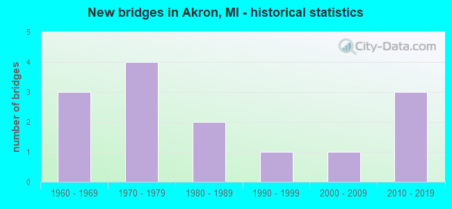
- New bridges - historical statistics
- 31960-1969
- 41970-1979
- 21980-1989
- 11990-1999
- 12000-2009
- 32010-2019

- Bridge Condition - Deck
- 22.2%Very good
- 44.4%Good
- 22.2%Satisfactory
- 11.1%Fair

- Bridge Condition - Superstructure
- 22.2%Very good
- 44.4%Good
- 11.1%Satisfactory
- 22.2%Fair

- Bridge Condition - Substructure
- 22.2%Very good
- 55.6%Good
- 11.1%Satisfactory
- 11.1%Fair

- Bridge Condition - Channel
- 7.1%Very good
- 42.9%Good
- 28.6%Satisfactory
- 21.4%Fair

- Bridge Condition - Culverts
- 40.0%Very good
- 40.0%Good
- 20.0%Satisfactory
Find on map >> Show street view
Structure Number: 104, Location: W LTS OF AKRON (Lat: 43.566258, Lng: -83.523314), Route carried "on" structure: State highway 138, Year Built: 1968, Status: Open, Structure Length: 1.22m (4.00ft), Average Daily Traffic: 1,678 (year 2007), Truck Traffic: 7%, Average Future Daily Traffic: 1,642 (year 2018), Design Load: HS 20, Features Intersected: ALLEN DRAIN
Minimum Vertical Clearance: 30.48m (100.00ft), Kilometerpoint: 12.886, Lanes on structure: 2, Base Highway Network: Yes (Inventory Route: 27, Subroute: 6), Owner: State Highway Agency, Approaching Roadway Width: 12.8m (42.0ft), Material/Design: Steel, Design/Construction: Stringer/Multi-beam, Number Of Spans In Main Unit: 1, Length of Maximum Span: 12.2m (40.0ft), Curb or Sidewalk Widths: Left: 0.2m (0.7ft), Right: 0.2m (0.7ft), Curb-To-Curb Width: 12.5m (41.0ft), Out-to-Out Width: 13.3m (43.6ft)
Condition: Deck: Satisfactory, Superstructure: Satisfactory, Substructure: Good, Channel: Satisfactory, Operating Rating: 59.3 metric tons, Method Used To Determine Operating Rating: Load Factor (LF) rating reported by rating factor (RF) method using MS18 loading, Inventory Rating: 35.3 metric tons, Method Used To Determine Inventory Rating: Load Factor (LF) rating reported by rating factor (RF) method using MS18 loading, Structural Evaluation: Equal to present minimum criteria, Deck Geometry: Better than present minimum criteria, Waterway Adequacy: Equal to present desirable criteria, Approach Roadway Alignment: Equal to present desirable criteria, Designated Inspection Frequency: Every 24 months, Inspection Date: August 2020, Deck Structure Type: Concrete Cast-file-Place, Wearing Surface/Protective System: Wearing Surface: Epoxy Overlay
Find on map >> Show street view
Structure Number: 10401, Location: 4.5 MI S OF M-25 (Lat: 43.590319, Lng: -83.465056), Route carried "on" structure: State highway 138, Year Built: 1983, Status: Open, Structure Length: 1.03m (3.38ft), Average Daily Traffic: 1,825 (year 2007), Truck Traffic: 11%, Average Future Daily Traffic: 2,004 (year 2018), Design Load: HS 25 or greater, Features Intersected: WISCOGGIN CREEK, Facility Carried by Structure: M-24
Minimum Vertical Clearance: 30.48m (100.00ft), Kilometerpoint: 5.807, Lanes on structure: 2, Base Highway Network: Yes (Inventory Route: 27, Subroute: 9), Owner: State Highway Agency, Approaching Roadway Width: 7.3m (24.0ft), Skew: 1 degrees, Material/Design: Prestressed concrete, Design/Construction: Box Beam or Girders - Multiple, Number Of Spans In Main Unit: 1, Length of Maximum Span: 10.2m (33.5ft), Curb-To-Curb Width: 9.2m (30.2ft), Out-to-Out Width: 10.4m (34.1ft)
Condition: Deck: Good, Superstructure: Good, Substructure: Fair, Channel: Fair, Operating Rating: 63.5 metric tons, Method Used To Determine Operating Rating: Load Factor (LF) rating reported by rating factor (RF) method using MS18 loading, Inventory Rating: 37.9 metric tons, Method Used To Determine Inventory Rating: Load Factor (LF) rating reported by rating factor (RF) method using MS18 loading, Structural Evaluation: Somewhat better than minimum adequacy, Deck Geometry: Somewhat better than minimum adequacy, Waterway Adequacy: Equal to present desirable criteria, Approach Roadway Alignment: Equal to present desirable criteria, Designated Inspection Frequency: Every 24 months, Inspection Date: August 2020, Deck Structure Type: Concrete Precast Panels, Wearing Surface/Protective System: Wearing Surface: Bituminous, Membrane: Preformed Fabric
Find on map >> Show street view
Structure Number: 10474, Location: SEC 6-7 ALMER TWP (Lat: 43.567203, Lng: -83.453822), Route carried "on" structure: County highway , Year Built: 1971, Status: Open, Structure Length: 0.91m (2.99ft), Average Daily Traffic: 430 (year 2009), Average Future Daily Traffic: 780 (year 2029), Design Load: HS 20, Features Intersected: WISCOGGIN DRAIN, Facility Carried by Structure: AKRON ROAD
Minimum Vertical Clearance: 30.48m (100.00ft), Kilometerpoint: 18.502, Lanes on structure: 2, Owner: County Highway Agency, Approaching Roadway Width: 9.1m (29.9ft), Material/Design: Prestressed concrete, Design/Construction: Box Beam or Girders - Multiple, Number Of Spans In Main Unit: 1, Length of Maximum Span: 8.7m (28.5ft), Curb-To-Curb Width: 11.0m (36.1ft), Out-to-Out Width: 11.1m (36.4ft)
Condition: Deck: Satisfactory, Superstructure: Good, Substructure: Good, Channel: Good, Operating Rating: 90.1 metric tons, Method Used To Determine Operating Rating: Load Factor (LF) rating reported by rating factor (RF) method using MS18 loading, Inventory Rating: 54.1 metric tons, Method Used To Determine Inventory Rating: Load Factor (LF) rating reported by rating factor (RF) method using MS18 loading, Structural Evaluation: Better than present minimum criteria, Deck Geometry: Better than present minimum criteria, Waterway Adequacy: Equal to present desirable criteria, Approach Roadway Alignment: Equal to present desirable criteria, Designated Inspection Frequency: Every 24 months, Inspection Date: June 2021, Deck Structure Type: Concrete Precast Panels, Wearing Surface/Protective System: Wearing Surface: Bituminous
Find on map >> Show street view
Structure Number: 10477, Location: SEC 17-20 AKRON TWP (Lat: 43.609275, Lng: -83.564761), Route carried "on" structure: County highway 7986, Year Built: 1971, Status: Open, Structure Length: 0.91m (2.99ft), Average Daily Traffic: 1,300 (year 2009), Average Future Daily Traffic: 2,350 (year 2029), Design Load: HS 20, Features Intersected: ALLEN DRAIN, Facility Carried by Structure: DICKERSON ROAD
Minimum Vertical Clearance: 30.48m (100.00ft), Kilometerpoint: 2.979, Lanes on structure: 2, Owner: County Highway Agency, Approaching Roadway Width: 10.4m (34.1ft), Material/Design: Prestressed concrete, Design/Construction: Box Beam or Girders - Multiple, Number Of Spans In Main Unit: 1, Length of Maximum Span: 8.4m (27.6ft), Curb-To-Curb Width: 11.0m (36.1ft), Out-to-Out Width: 11.1m (36.4ft)
Condition: Deck: Good, Superstructure: Good, Substructure: Good, Channel: Good, Operating Rating: 65.4 metric tons, Method Used To Determine Operating Rating: Load Factor (LF) rating reported by rating factor (RF) method using MS18 loading, Inventory Rating: 39.2 metric tons, Method Used To Determine Inventory Rating: Load Factor (LF) rating reported by rating factor (RF) method using MS18 loading, Structural Evaluation: Better than present minimum criteria, Deck Geometry: Equal to present minimum criteria, Waterway Adequacy: Better than present minimum criteria, Approach Roadway Alignment: Equal to present desirable criteria, Designated Inspection Frequency: Every 24 months, Inspection Date: April 2021, Deck Structure Type: Concrete Precast Panels, Wearing Surface/Protective System: Wearing Surface: Bituminous
Find on map >> Show street view
Structure Number: 10478, Location: SEC 17-20 AKRON TWP (Lat: 43.609397, Lng: -83.554894), Route carried "on" structure: County highway 7986, Year Built: 2009, Status: Open, Structure Length: 0.76m (2.49ft), Average Daily Traffic: 1,300 (year 2009), Average Future Daily Traffic: 2,350 (year 2029), Design Load: HS 20, Features Intersected: LATIMER OR ALLEN RELIEF, Facility Carried by Structure: DICKERSON ROAD
Minimum Vertical Clearance: 30.48m (100.00ft), Kilometerpoint: 3.776, Lanes on structure: 2, Owner: County Highway Agency, Approaching Roadway Width: 9.1m (29.9ft), Skew: 4 degrees, Material/Design: Concrete, Design/Construction: Culvert, Number Of Spans In Main Unit: 1, Length of Maximum Span: 7.6m (24.9ft), Curb-To-Curb Width: 8.5m (27.9ft), Out-to-Out Width: 11.6m (38.1ft)
Condition: Channel: Good, Culverts: Very good, Operating Rating: 38.1 metric tons, Method Used To Determine Operating Rating: Field evaluation and documented engineering judgment, Inventory Rating: 32.7 metric tons, Method Used To Determine Inventory Rating: Field evaluation and documented engineering judgment, Structural Evaluation: Equal to present desirable criteria, Deck Geometry: Somewhat better than minimum adequacy, Waterway Adequacy: Equal to present minimum criteria, Approach Roadway Alignment: Equal to present minimum criteria, Designated Inspection Frequency: Every 24 months, Inspection Date: April 2021, Wearing Surface/Protective System: Wearing Surface: Bituminous
Find on map >> Show street view
Structure Number: 10536, Location: SEC 29-32 AKRON TWP (Lat: 43.580325, Lng: -83.563858), Route carried "on" structure: ServiceCounty highway , Year Built: 1992, Status: Open, Structure Length: 0.73m (2.40ft), Average Daily Traffic: 225 (year 2009), Average Future Daily Traffic: 410 (year 2029), Design Load: HS 20, Features Intersected: ALLEN DRAIN, Facility Carried by Structure: ELMWOOD ROAD
Minimum Vertical Clearance: 30.48m (100.00ft), Kilometerpoint: 8.441, Lanes on structure: 2, Owner: County Highway Agency, Approaching Roadway Width: 9.1m (29.9ft), Skew: 4 degrees, Material/Design: Concrete, Design/Construction: Culvert, Number Of Spans In Main Unit: 1, Length of Maximum Span: 7.3m (24.0ft), Curb-To-Curb Width: 9.8m (32.2ft), Out-to-Out Width: 9.8m (32.2ft)
Condition: Channel: Good, Culverts: Good, Operating Rating: 54.5 metric tons, Method Used To Determine Operating Rating: Field evaluation and documented engineering judgment, Inventory Rating: 32.7 metric tons, Method Used To Determine Inventory Rating: Field evaluation and documented engineering judgment, Structural Evaluation: Better than present minimum criteria, Deck Geometry: Better than present minimum criteria, Waterway Adequacy: Better than present minimum criteria, Approach Roadway Alignment: Equal to present desirable criteria, Designated Inspection Frequency: Every 24 months, Inspection Date: April 2021
Find on map >> Show street view
Structure Number: 10539, Location: SEC 20-29 AKRON TWP (Lat: 43.594900, Lng: -83.554500), Route carried "on" structure: ServiceCounty highway , Year Built: 2016, Status: Open, Structure Length: 0.67m (2.20ft), Average Daily Traffic: 72 (year 2009), Average Future Daily Traffic: 130 (year 2029), Design Load: H 15, Features Intersected: LATIMER OR ALLEN RELIEF, Facility Carried by Structure: CASS CITY ROAD
Minimum Vertical Clearance: 30.48m (100.00ft), Kilometerpoint: 7.371, Lanes on structure: 2, Owner: County Highway Agency, Approaching Roadway Width: 6.7m (22.0ft), Material/Design: Concrete, Design/Construction: Culvert, Number Of Spans In Main Unit: 1, Length of Maximum Span: 6.1m (20.0ft), Curb-To-Curb Width: 11.6m (38.1ft), Out-to-Out Width: 12.2m (40.0ft)
Condition: Channel: Very good, Culverts: Very good, Operating Rating: 94.0 metric tons, Method Used To Determine Operating Rating: Load and Resistance Factor Rating (LRFR) rating reported by rating factor(RF) method using HL-93 loadings, Inventory Rating: 51.8 metric tons, Method Used To Determine Inventory Rating: Load and Resistance Factor Rating (LRFR) rating reported by rating factor(RF) method using HL-93 loadings, Structural Evaluation: Equal to present desirable criteria, Deck Geometry: Superior to present desirable criteria, Waterway Adequacy: Equal to present desirable criteria, Approach Roadway Alignment: Equal to present desirable criteria, Length Of Structure Improvement: 1.34m (4.40ft), Designated Inspection Frequency: Every 24 months, Inspection Date: September 2020, Bridge Improvement Cost: $248,000, Roadway Improvement Cost: $25,000, Total Project Cost: $290,000, Wearing Surface/Protective System: Wearing Surface: Bituminous, Membrane: Preformed Fabric
Find on map >> Show street view
Structure Number: 1054, Location: SEC 24-25 AKRON TWP (Lat: 43.595819, Lng: -83.470581), Route carried "on" structure: ServiceCounty highway , Year Built: 1984, Status: Open, Structure Length: 1.10m (3.61ft), Average Daily Traffic: 78 (year 2009), Average Future Daily Traffic: 140 (year 2029), Design Load: HS 20, Features Intersected: WISCOGGIN DRAIN, Facility Carried by Structure: CASS CITY ROAD
Minimum Vertical Clearance: 30.48m (100.00ft), Kilometerpoint: 13.337, Lanes on structure: 2, Owner: County Highway Agency, Approaching Roadway Width: 9.1m (29.9ft), Skew: 3 degrees, Material/Design: Prestressed concrete, Design/Construction: Tee Beam, Number Of Spans In Main Unit: 1, Length of Maximum Span: 9.9m (32.5ft), Curb-To-Curb Width: 9.4m (30.8ft), Out-to-Out Width: 9.9m (32.5ft)
Condition: Deck: Good, Superstructure: Good, Substructure: Good, Channel: Satisfactory, Operating Rating: 56.1 metric tons, Method Used To Determine Operating Rating: Load Factor (LF) rating reported by rating factor (RF) method using MS18 loading, Inventory Rating: 34.0 metric tons, Method Used To Determine Inventory Rating: Load Factor (LF) rating reported by rating factor (RF) method using MS18 loading, Structural Evaluation: Better than present minimum criteria, Deck Geometry: Better than present minimum criteria, Waterway Adequacy: Equal to present desirable criteria, Approach Roadway Alignment: Equal to present desirable criteria, Designated Inspection Frequency: Every 24 months, Inspection Date: April 2021, Deck Structure Type: Concrete Precast Panels, Wearing Surface/Protective System: Wearing Surface: Bituminous, Membrane: Preformed Fabric, Deck Protection: Epoxy Coated Reinforcing
Find on map >> Show street view
Structure Number: 10543, Location: SEC 32-33 AKRON TWP (Lat: 43.576264, Lng: -83.544211), Route carried "on" structure: ServiceCounty highway , Year Built: 2014, Status: Open, Structure Length: 1.49m (4.89ft), Average Daily Traffic: 175 (year 2014), Truck Traffic: 3%, Average Future Daily Traffic: 315 (year 2034), Design Load: Greater than HL93, Features Intersected: ALLEN EXT DRAIN, Facility Carried by Structure: THOMAS ROAD
Minimum Vertical Clearance: 30.48m (100.00ft), Kilometerpoint: 20.266, Lanes on structure: 2, Owner: County Highway Agency, Approaching Roadway Width: 8.5m (27.9ft), Skew: 1 degrees, Material/Design: Prestressed concrete, Design/Construction: Stringer/Multi-beam, Number Of Spans In Main Unit: 1, Length of Maximum Span: 14.2m (46.6ft), Curb-To-Curb Width: 8.5m (27.9ft), Out-to-Out Width: 9.7m (31.8ft)
Condition: Deck: Very good, Superstructure: Very good, Substructure: Very good, Channel: Good, Operating Rating: 42.7 metric tons, Method Used To Determine Operating Rating: Field evaluation and documented engineering judgment, Inventory Rating: 32.9 metric tons, Method Used To Determine Inventory Rating: Field evaluation and documented engineering judgment, Structural Evaluation: Equal to present desirable criteria, Deck Geometry: Equal to present minimum criteria, Waterway Adequacy: Better than present minimum criteria, Approach Roadway Alignment: Better than present minimum criteria, Designated Inspection Frequency: Every 24 months, Inspection Date: September 2020, Deck Structure Type: Concrete Cast-file-Place, Wearing Surface/Protective System: Wearing Surface: Epoxy Overlay, Deck Protection: Epoxy Coated Reinforcing
Find on map >> Show street view
Structure Number: 10544, Location: SEC 18-19 ALMER TWP (Lat: 43.538136, Lng: -83.457275), Route carried "on" structure: ServiceCounty highway , Year Built: 1979, Status: Open, Structure Length: 0.88m (2.89ft), Average Daily Traffic: 60 (year 2009), Average Future Daily Traffic: 110 (year 2029), Design Load: H 20, Features Intersected: WISCOGGIN DRAIN, Facility Carried by Structure: DARBEE ROAD
Minimum Vertical Clearance: 30.48m (100.00ft), Kilometerpoint: 19.548, Lanes on structure: 2, Owner: County Highway Agency, Approaching Roadway Width: 8.5m (27.9ft), Skew: 2 degrees, Material/Design: Steel, Design/Construction: Culvert, Number Of Spans In Main Unit: 2, Length of Maximum Span: 3.6m (11.8ft)
Condition: Channel: Fair, Culverts: Satisfactory, Operating Rating: 97.2 metric tons, Method Used To Determine Operating Rating: Load Factor (LF) rating reported by rating factor (RF) method using MS18 loading, Inventory Rating: 97.2 metric tons, Method Used To Determine Inventory Rating: Load Factor (LF) rating reported by rating factor (RF) method using MS18 loading, Structural Evaluation: Equal to present minimum criteria, Waterway Adequacy: Better than present minimum criteria, Approach Roadway Alignment: Equal to present desirable criteria, Designated Inspection Frequency: Every 24 months, Inspection Date: June 2021
Find on map >> Show street view
Structure Number: 10545, Location: SEC 7-18 ALMER TWP (Lat: 43.552736, Lng: -83.451311), Route carried "on" structure: ServiceCounty highway , Year Built: 1979, Status: Open, Structure Length: 1.10m (3.61ft), Average Daily Traffic: 70 (year 2009), Average Future Daily Traffic: 120 (year 2029), Design Load: H 20, Features Intersected: WISCOGGIN DRAIN, Facility Carried by Structure: DUTCHER ROAD
Minimum Vertical Clearance: 30.48m (100.00ft), Kilometerpoint: 20.031, Lanes on structure: 2, Owner: County Highway Agency, Approaching Roadway Width: 7.9m (25.9ft), Skew: 2 degrees, Material/Design: Steel, Design/Construction: Culvert, Number Of Spans In Main Unit: 2, Length of Maximum Span: 4.5m (14.8ft)
Condition: Channel: Satisfactory, Culverts: Good, Operating Rating: 97.2 metric tons, Method Used To Determine Operating Rating: Load Factor (LF) rating reported by rating factor (RF) method using MS18 loading, Inventory Rating: 97.2 metric tons, Method Used To Determine Inventory Rating: Load Factor (LF) rating reported by rating factor (RF) method using MS18 loading, Structural Evaluation: Better than present minimum criteria, Waterway Adequacy: Equal to present desirable criteria, Approach Roadway Alignment: Better than present minimum criteria, Designated Inspection Frequency: Every 24 months, Inspection Date: June 2021
Find on map >> Show street view
Structure Number: 10554, Location: SEC 31 COLUMBIA TWP (Lat: 43.581256, Lng: -83.457350), Route carried "on" structure: ServiceCounty highway , Year Built: 2013, Status: Open, Structure Length: 1.49m (4.89ft), Average Daily Traffic: 202 (year 2012), Truck Traffic: 2%, Average Future Daily Traffic: 365 (year 2032), Design Load: Greater than HL93, Features Intersected: WISCOGGIN DRAIN, Facility Carried by Structure: ELMWOOD ROAD
Minimum Vertical Clearance: 30.48m (100.00ft), Kilometerpoint: 17.047, Lanes on structure: 2, Owner: County Highway Agency, Approaching Roadway Width: 8.5m (27.9ft), Material/Design: Prestressed concrete, Design/Construction: Stringer/Multi-beam, Number Of Spans In Main Unit: 1, Length of Maximum Span: 14.2m (46.6ft), Curb-To-Curb Width: 8.5m (27.9ft), Out-to-Out Width: 9.4m (30.8ft)
Condition: Deck: Very good, Superstructure: Very good, Substructure: Very good, Channel: Good, Operating Rating: 65.1 metric tons, Method Used To Determine Operating Rating: Load and Resistance Factor Rating (LRFR) rating reported by rating factor(RF) method using HL-93 loadings, Inventory Rating: 50.2 metric tons, Method Used To Determine Inventory Rating: Load and Resistance Factor Rating (LRFR) rating reported by rating factor(RF) method using HL-93 loadings, Structural Evaluation: Equal to present desirable criteria, Deck Geometry: Equal to present minimum criteria, Waterway Adequacy: Better than present minimum criteria, Approach Roadway Alignment: Equal to present desirable criteria, Designated Inspection Frequency: Every 24 months, Inspection Date: June 2020, Deck Structure Type: Concrete Cast-file-Place, Wearing Surface/Protective System: Wearing Surface: Monolithic Concrete, Deck Protection: Epoxy Coated Reinforcing
Find on map >> Show street view
Structure Number: 10587, Location: SEC 3-4 FAIRGROVE TWP (Lat: 43.564908, Lng: -83.524356), Route carried "on" structure: ServiceCounty highway , Year Built: 1964, Status: Open, Structure Length: 0.94m (3.08ft), Average Daily Traffic: 390 (year 2009), Average Future Daily Traffic: 700 (year 2029), Design Load: H 20, Features Intersected: ALLEN EXTN DRAIN, Facility Carried by Structure: RINGLE ROAD
Minimum Vertical Clearance: 30.48m (100.00ft), Kilometerpoint: 19.015, Lanes on structure: 2, Owner: County Highway Agency, Approaching Roadway Width: 9.1m (29.9ft), Material/Design: Steel, Design/Construction: Stringer/Multi-beam, Number Of Spans In Main Unit: 1, Length of Maximum Span: 8.8m (28.9ft), Curb-To-Curb Width: 9.0m (29.5ft), Out-to-Out Width: 9.6m (31.5ft)
Condition: Deck: Fair, Superstructure: Fair, Substructure: Good, Channel: Satisfactory, Operating Rating: 66.1 metric tons, Method Used To Determine Operating Rating: Load Factor (LF) rating reported by rating factor (RF) method using MS18 loading, Inventory Rating: 39.5 metric tons, Method Used To Determine Inventory Rating: Load Factor (LF) rating reported by rating factor (RF) method using MS18 loading, Structural Evaluation: Somewhat better than minimum adequacy, Deck Geometry: Equal to present minimum criteria, Waterway Adequacy: Better than present minimum criteria, Approach Roadway Alignment: Equal to present desirable criteria, Designated Inspection Frequency: Every 12 months, Inspection Date: May 2021, Deck Structure Type: Concrete Cast-file-Place, Wearing Surface/Protective System: Wearing Surface: Monolithic Concrete
Find on map >> Show street view
Structure Number: 10588, Location: SEC 3-4 FAIRGROVE TWP (Lat: 43.560700, Lng: -83.524286), Route carried "on" structure: ServiceCounty highway , Year Built: 1965, Status: Open, Structure Length: 0.92m (3.02ft), Average Daily Traffic: 390 (year 2009), Average Future Daily Traffic: 700 (year 2029), Design Load: H 20, Features Intersected: ALLEN EXTN DRAIN, Facility Carried by Structure: RINGLE ROAD
Minimum Vertical Clearance: 30.48m (100.00ft), Kilometerpoint: 18.548, Lanes on structure: 2, Owner: County Highway Agency, Approaching Roadway Width: 9.1m (29.9ft), Material/Design: Steel, Design/Construction: Stringer/Multi-beam, Number Of Spans In Main Unit: 1, Length of Maximum Span: 9.0m (29.5ft), Curb-To-Curb Width: 7.9m (25.9ft), Out-to-Out Width: 8.4m (27.6ft)
Condition: Deck: Good, Superstructure: Fair, Substructure: Satisfactory, Channel: Fair, Operating Rating: 50.5 metric tons, Method Used To Determine Operating Rating: Load Factor (LF) rating reported by rating factor (RF) method using MS18 loading, Inventory Rating: 30.1 metric tons, Method Used To Determine Inventory Rating: Load Factor (LF) rating reported by rating factor (RF) method using MS18 loading, Structural Evaluation: Somewhat better than minimum adequacy, Deck Geometry: Somewhat better than minimum adequacy, Waterway Adequacy: Better than present minimum criteria, Approach Roadway Alignment: Equal to present minimum criteria, Designated Inspection Frequency: Every 24 months, Inspection Date: May 2021, Deck Structure Type: Concrete Cast-file-Place, Wearing Surface/Protective System: Wearing Surface: Monolithic Concrete