Bridge Statistics for Aiken, South Carolina (SC)
Condition, Traffic, Stress, Structural Evaluation, Project Costs
- National Bridge Inventory (NBI) Statistics
- 24Number of bridges
- 180ft / 55.4mTotal length
- $2,227,000Total costs
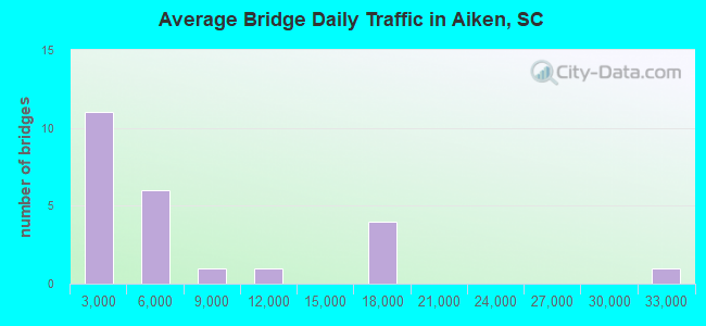
- 153,025Total average daily traffic
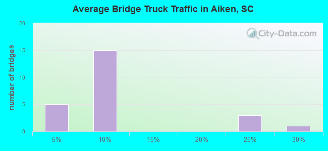
- 21,907Total average daily truck traffic
- National Bridge Inventory (NBI) Registered Bridges for Aiken
- No street view available for this location
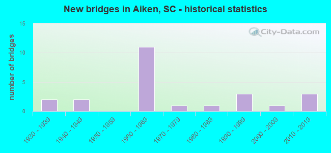
- New bridges - historical statistics
- 21930-1939
- 21940-1949
- 111960-1969
- 11970-1979
- 11980-1989
- 31990-1999
- 12000-2009
- 32010-2019
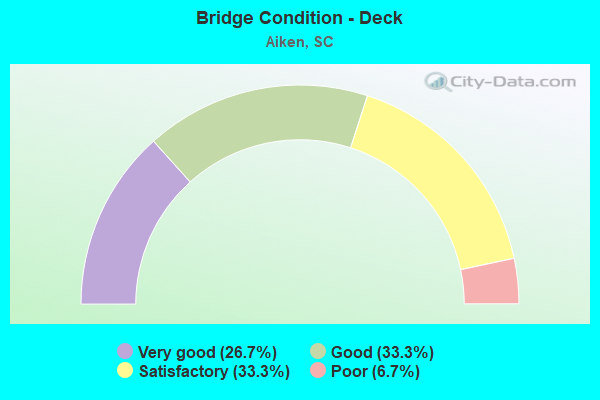
- Bridge Condition - Deck
- 26.7%Very good
- 33.3%Good
- 33.3%Satisfactory
- 6.7%Poor
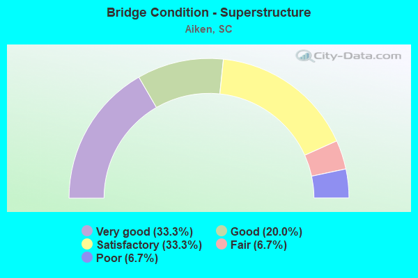
- Bridge Condition - Superstructure
- 33.3%Very good
- 20.0%Good
- 33.3%Satisfactory
- 6.7%Fair
- 6.7%Poor
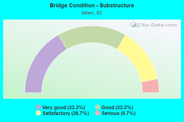
- Bridge Condition - Substructure
- 33.3%Very good
- 33.3%Good
- 26.7%Satisfactory
- 6.7%Serious
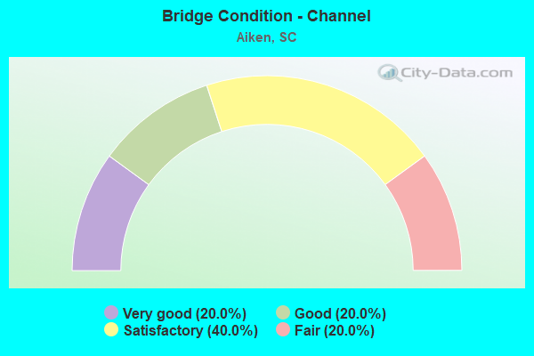
- Bridge Condition - Channel
- 20.0%Very good
- 20.0%Good
- 40.0%Satisfactory
- 20.0%Fair
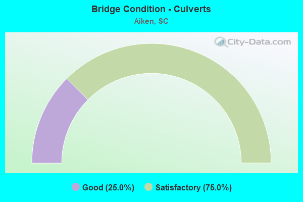
- Bridge Condition - Culverts
- 25.0%Good
- 75.0%Satisfactory
Find on map >> Show street view
Structure Number: 444, Location: 1 MI NW CLIO (Lat: 34.593114, Lng: -79.561206), Route carried "on" structure: State highway 22, Year Built: 1930, Status: Open, Structure Length: 0.64m (2.10ft), Average Daily Traffic: 275 (year 2020), Truck Traffic: 9%, Average Future Daily Traffic: 382 (year 2040), Design Load: H 15, Features Intersected: HAGINS PRONG CREEK
Minimum Vertical Clearance: 30+ m (98+ ft), Kilometerpoint: 12.184, Lanes on structure: 2, Owner: State Highway Agency, Approaching Roadway Width: 6.1m (20.0ft), Material/Design: Concrete, Design/Construction: Culvert, Number Of Spans In Main Unit: 2, Length of Maximum Span: 3.0m (9.8ft), Curb-To-Curb Width: 8.5m (27.9ft), Out-to-Out Width: 9.1m (29.9ft)
Condition: Channel: Very good, Culverts: Satisfactory, Operating Rating: 16.8 metric tons, Method Used To Determine Operating Rating: Load and Resistance Factor Rating (LRFR) rating reported by rating factor(RF) method using HL-93 loadings, Inventory Rating: 13.0 metric tons, Method Used To Determine Inventory Rating: Load and Resistance Factor Rating (LRFR) rating reported by rating factor(RF) method using HL-93 loadings, Structural Evaluation: Meets minimum limits, Deck Geometry: Equal to present minimum criteria, Waterway Adequacy: Equal to present desirable criteria, Approach Roadway Alignment: Equal to present desirable criteria, Length Of Structure Improvement: 0.64m (2.10ft), Designated Inspection Frequency: Every 24 months, Inspection Date: March 2021
Find on map >> Show street view
Structure Number: 758, Location: CHESTERFIELD ST AIKEN (Lat: 33.557342, Lng: -81.720992), Route carried "on" structure: State highway 19, Year Built: 1937, Year Reconstructed: 1995, Status: Open, Structure Length: 3.20m (10.50ft), Average Daily Traffic: 7,500 (year 2020), Truck Traffic: 6%, Average Future Daily Traffic: 8,250 (year 2040), Design Load: H 15, Features Intersected: SOUTHERN RWY (ABANDONED)
Minimum Vertical Clearance: 30+ m (98+ ft), Kilometerpoint: 19.940, Lanes on structure: 2, Base Highway Network: Yes, Owner: State Highway Agency, Approaching Roadway Width: 12.2m (40.0ft), Skew: 1 degrees, Material/Design: Concrete, Design/Construction: Tee Beam, Number Of Spans In Main Unit: 3, Length of Maximum Span: 10.7m (35.1ft), Curb or Sidewalk Widths: Left: 1.2m (3.9ft), Right: 1.2m (3.9ft), Curb-To-Curb Width: 9.1m (29.9ft), Out-to-Out Width: 12.2m (40.0ft)
Condition: Deck: Good, Superstructure: Satisfactory, Substructure: Satisfactory, Operating Rating: 43.7 metric tons, Method Used To Determine Operating Rating: Load and Resistance Factor Rating (LRFR) rating reported by rating factor(RF) method using HL-93 loadings, Inventory Rating: 33.7 metric tons, Method Used To Determine Inventory Rating: Load and Resistance Factor Rating (LRFR) rating reported by rating factor(RF) method using HL-93 loadings, Structural Evaluation: Equal to present minimum criteria, Deck Geometry: High priority of corrective action, Underclear: Meets minimum limits, Approach Roadway Alignment: Equal to present desirable criteria, Length Of Structure Improvement: 4.06m (13.32ft), Designated Inspection Frequency: Every 24 months, Inspection Date: Febuary 2020, Bridge Improvement Cost: $185,000, Roadway Improvement Cost: $46,000, Total Project Cost: $278,000 ( Estimate for 2021), Deck Structure Type: Concrete Cast-file-Place, Wearing Surface/Protective System: Wearing Surface: Bituminous
Find on map >> Show street view
Structure Number: 1235, Location: 4.0 MI S VAUCLUSE (Lat: 33.590939, Lng: -81.761025), Route carried "on" structure: State highway 105, Year Built: 1942, Status: Open, Structure Length: 0.70m (2.30ft), Average Daily Traffic: 1,550 (year 2020), Truck Traffic: 2%, Average Future Daily Traffic: 1,597 (year 2040), Design Load: H 20, Features Intersected: BRIDGE CREEK
Minimum Vertical Clearance: 30+ m (98+ ft), Kilometerpoint: 4.176, Lanes on structure: 2, Owner: State Highway Agency, Approaching Roadway Width: 6.4m (21.0ft), Material/Design: Masonry, Design/Construction: Culvert, Number Of Spans In Main Unit: 1, Length of Maximum Span: 7.0m (23.0ft), Curb-To-Curb Width: 6.5m (21.3ft), Out-to-Out Width: 7.3m (24.0ft)
Condition: Channel: Fair, Culverts: Satisfactory, Operating Rating: 30.8 metric tons, Method Used To Determine Operating Rating: Field evaluation and documented engineering judgment, Inventory Rating: 22.7 metric tons, Method Used To Determine Inventory Rating: Field evaluation and documented engineering judgment, Structural Evaluation: Equal to present minimum criteria, Deck Geometry: High priority of replacement, Waterway Adequacy: High priority of corrective action, Approach Roadway Alignment: Equal to present desirable criteria, Length Of Structure Improvement: 1.32m (4.33ft), Designated Inspection Frequency: Every 24 months, Underwater Inspection Frequency: Every 24 months, Inspection Date: November 2020, Underwater Inspection Date: November 2020, Bridge Improvement Cost: $73,000, Roadway Improvement Cost: $18,000, Total Project Cost: $110,000 ( Estimate for 2021), Deck Structure Type: Concrete Cast-file-Place, Wearing Surface/Protective System: Wearing Surface: Bituminous
Find on map >> Show street view
Structure Number: 1416, Location: 3.0 MI NE AIKEN (Lat: 33.619739, Lng: -81.702456), Route carried "on" structure: State highway 26, Year Built: 1948, Status: Open, Structure Length: 1.20m (3.94ft), Average Daily Traffic: 2,300 (year 2020), Truck Traffic: 4%, Average Future Daily Traffic: 3,059 (year 2040), Design Load: H 15, Features Intersected: SHAW CREEK SPILLWAY
Minimum Vertical Clearance: 30+ m (98+ ft), Kilometerpoint: 2.515, Lanes on structure: 2, Owner: State Highway Agency, Approaching Roadway Width: 7.2m (23.6ft), Material/Design: Concrete, Design/Construction: Culvert, Number Of Spans In Main Unit: 3, Length of Maximum Span: 3.7m (12.1ft), Curb-To-Curb Width: 9.8m (32.2ft), Out-to-Out Width: 10.3m (33.8ft)
Condition: Channel: Good, Culverts: Good, Operating Rating: 53.5 metric tons, Method Used To Determine Operating Rating: Load and Resistance Factor Rating (LRFR) rating reported by rating factor(RF) method using HL-93 loadings, Inventory Rating: 41.1 metric tons, Method Used To Determine Inventory Rating: Load and Resistance Factor Rating (LRFR) rating reported by rating factor(RF) method using HL-93 loadings, Structural Evaluation: Better than present minimum criteria, Deck Geometry: Meets minimum limits, Waterway Adequacy: Better than present minimum criteria, Approach Roadway Alignment: Equal to present minimum criteria, Length Of Structure Improvement: 1.20m (3.94ft), Designated Inspection Frequency: Every 24 months, Inspection Date: Febuary 2021
Find on map >> Show street view
Structure Number: 4246, Location: IN AIKEN (Lat: 33.555311, Lng: -81.768011), Route carried "on" structure: State highway 225, Year Built: 1964, Status: Posted for load, Structure Length: 1.83m (6.00ft), Average Daily Traffic: 650 (year 2020), Truck Traffic: 3%, Average Future Daily Traffic: 852 (year 2040), Design Load: H 10, Features Intersected: UNNAMED STREAM
Minimum Vertical Clearance: 30+ m (98+ ft), Kilometerpoint: 3.549, Lanes on structure: 2, Owner: State Highway Agency, Approaching Roadway Width: 6.6m (21.7ft), Material/Design: Concrete, Design/Construction: Slab, Number Of Spans In Main Unit: 4, Length of Maximum Span: 4.6m (15.1ft), Curb-To-Curb Width: 7.9m (25.9ft), Out-to-Out Width: 8.4m (27.6ft)
Condition: Deck: Good, Superstructure: Good, Substructure: Good, Channel: Satisfactory, Operating Rating: 20.7 metric tons, Method Used To Determine Operating Rating: Load and Resistance Factor Rating (LRFR) rating reported by rating factor(RF) method using HL-93 loadings, Inventory Rating: 15.9 metric tons, Method Used To Determine Inventory Rating: Load and Resistance Factor Rating (LRFR) rating reported by rating factor(RF) method using HL-93 loadings, Structural Evaluation: Meets minimum limits, Deck Geometry: Somewhat better than minimum adequacy, Waterway Adequacy: Somewhat better than minimum adequacy, Approach Roadway Alignment: Equal to present desirable criteria, Bridge Posting: Required (Relationship of Operating Rating to Maximum Legal Load: 30.0 - 39.9% below), Length Of Structure Improvement: 1.83m (6.00ft), Designated Inspection Frequency: Every 24 months, Other Special Inspection Frequency: Every 24 months, Inspection Date: January 2021, Other Special Inspection Date: July 2021, Deck Structure Type: Concrete Cast-file-Place, Wearing Surface/Protective System: Wearing Surface: Bituminous
Find on map >> Show street view
Structure Number: 444, Location: IN AIKEN (Lat: 33.556597, Lng: -81.753583), Route carried "on" structure: State highway 225, Year Built: 2002, Status: Open, Structure Length: 1.52m (4.99ft), Average Daily Traffic: 650 (year 2020), Truck Traffic: 3%, Average Future Daily Traffic: 852 (year 2040), Design Load: HS 20, Features Intersected: UNNAMED DRAINAGE DITCH
Minimum Vertical Clearance: 30+ m (98+ ft), Kilometerpoint: 2.063, Lanes on structure: 2, Owner: State Highway Agency, Approaching Roadway Width: 10.1m (33.1ft), Material/Design: Prestressed concrete, Design/Construction: Slab, Number Of Spans In Main Unit: 1, Length of Maximum Span: 15.2m (49.9ft), Curb-To-Curb Width: 10.1m (33.1ft), Out-to-Out Width: 11.0m (36.1ft)
Condition: Deck: Very good, Superstructure: Very good, Substructure: Very good, Channel: Satisfactory, Operating Rating: 40.5 metric tons, Method Used To Determine Operating Rating: Load and Resistance Factor Rating (LRFR) rating reported by rating factor(RF) method using HL-93 loadings, Inventory Rating: 30.1 metric tons, Method Used To Determine Inventory Rating: Load and Resistance Factor Rating (LRFR) rating reported by rating factor(RF) method using HL-93 loadings, Structural Evaluation: Better than present minimum criteria, Deck Geometry: Equal to present minimum criteria, Waterway Adequacy: Better than present minimum criteria, Approach Roadway Alignment: Equal to present desirable criteria, Length Of Structure Improvement: 1.52m (4.99ft), Designated Inspection Frequency: Every 24 months, Inspection Date: Febuary 2021, Deck Structure Type: Concrete Precast Panels, Wearing Surface/Protective System: Wearing Surface: Bituminous
Find on map >> Show street view
Structure Number: 519, Location: 6 MI N OF AIKEN (Lat: 33.639131, Lng: -81.740481), Route carried "on" structure: Interstate 20, Year Built: 1968, Status: Open, Structure Length: 6.46m (21.19ft), Average Daily Traffic: 15,950 (year 2020), Truck Traffic: 22%, Average Future Daily Traffic: 17,067 (year 2040), Design Load: HS 20, Features Intersected: S.C. 19
Minimum Vertical Clearance: 30+ m (98+ ft), Kilometerpoint: 28.524, Lanes on structure: 2, Lanes under structure: 4, Base Highway Network: Yes, Owner: State Highway Agency, Approaching Roadway Width: 11.3m (37.1ft), Skew: 3 degrees, Material/Design: Prestressed concrete, Design/Construction: Stringer/Multi-beam, Number Of Spans In Main Unit: 4, Length of Maximum Span: 16.2m (53.1ft), Curb-To-Curb Width: 11.7m (38.4ft), Out-to-Out Width: 12.7m (41.7ft)
Condition: Deck: Satisfactory, Superstructure: Good, Substructure: Satisfactory, Operating Rating: 63.8 metric tons, Method Used To Determine Operating Rating: Load and Resistance Factor Rating (LRFR) rating reported by rating factor(RF) method using HL-93 loadings, Inventory Rating: 49.2 metric tons, Method Used To Determine Inventory Rating: Load and Resistance Factor Rating (LRFR) rating reported by rating factor(RF) method using HL-93 loadings, Structural Evaluation: Equal to present minimum criteria, Deck Geometry: Equal to present minimum criteria, Underclear: Meets minimum limits, Approach Roadway Alignment: Equal to present desirable criteria, Length Of Structure Improvement: 6.46m (21.19ft), Designated Inspection Frequency: Every 24 months, Inspection Date: Febuary 2020, Deck Structure Type: Concrete Cast-file-Place, Wearing Surface/Protective System: Wearing Surface: Monolithic Concrete
Find on map >> Show street view
Structure Number: 5193, Location: 6 MI N OF AIKEN (Lat: 33.639303, Lng: -81.740736), Route carried "on" structure: Interstate 20, Year Built: 1968, Status: Open, Structure Length: 6.46m (21.19ft), Average Daily Traffic: 15,950 (year 2020), Truck Traffic: 25%, Average Future Daily Traffic: 17,067 (year 2040), Design Load: HS 20, Features Intersected: S.C. 19
Minimum Vertical Clearance: 30+ m (98+ ft), Kilometerpoint: 28.535, Lanes on structure: 2, Lanes under structure: 4, Base Highway Network: Yes, Owner: State Highway Agency, Approaching Roadway Width: 11.6m (38.1ft), Skew: 2 degrees, Material/Design: Prestressed concrete, Design/Construction: Stringer/Multi-beam, Number Of Spans In Main Unit: 4, Length of Maximum Span: 16.2m (53.1ft), Curb-To-Curb Width: 11.7m (38.4ft), Out-to-Out Width: 12.7m (41.7ft)
Condition: Deck: Satisfactory, Superstructure: Fair, Substructure: Satisfactory, Operating Rating: 78.0 metric tons, Method Used To Determine Operating Rating: Load Factor (LF), Inventory Rating: 57.2 metric tons, Method Used To Determine Inventory Rating: Load Factor (LF), Structural Evaluation: Somewhat better than minimum adequacy, Deck Geometry: Equal to present minimum criteria, Underclear: Meets minimum limits, Approach Roadway Alignment: Equal to present desirable criteria, Length Of Structure Improvement: 7.45m (24.44ft), Designated Inspection Frequency: Every 24 months, Inspection Date: Febuary 2020, Bridge Improvement Cost: $331,000, Roadway Improvement Cost: $83,000, Total Project Cost: $497,000 ( Estimate for 2021), Deck Structure Type: Concrete Cast-file-Place, Wearing Surface/Protective System: Wearing Surface: Monolithic Concrete
Find on map >> Show street view
Structure Number: 5201, Location: 5.0 MI N AIKEN (Lat: 33.635497, Lng: -81.762258), Route carried "on" structure: State highway 1663, Year Built: 1968, Status: Open, Structure Length: 8.90m (29.20ft), Average Daily Traffic: 125 (year 2020), Truck Traffic: 5%, Average Future Daily Traffic: 160 (year 2040), Design Load: HS 15, Features Intersected: I-20
Minimum Vertical Clearance: 30+ m (98+ ft), Kilometerpoint: 1.209, Lanes on structure: 2, Lanes under structure: 4, Owner: State Highway Agency, Approaching Roadway Width: 6.4m (21.0ft), Skew: 2 degrees, Material/Design: Steel, Design/Construction: Stringer/Multi-beam, Number Of Spans In Main Unit: 2, Number Of Approach Spans: 2, Length of Maximum Span: 24.4m (80.1ft), Curb-To-Curb Width: 7.9m (25.9ft), Out-to-Out Width: 9.1m (29.9ft)
Condition: Deck: Good, Superstructure: Satisfactory, Substructure: Good, Operating Rating: 53.8 metric tons, Method Used To Determine Operating Rating: Load and Resistance Factor Rating (LRFR) rating reported by rating factor(RF) method using HL-93 loadings, Inventory Rating: 41.1 metric tons, Method Used To Determine Inventory Rating: Load and Resistance Factor Rating (LRFR) rating reported by rating factor(RF) method using HL-93 loadings, Structural Evaluation: Equal to present minimum criteria, Deck Geometry: Somewhat better than minimum adequacy, Underclear: Somewhat better than minimum adequacy, Approach Roadway Alignment: Equal to present desirable criteria, Length Of Structure Improvement: 8.90m (29.20ft), Designated Inspection Frequency: Every 24 months, Inspection Date: Febuary 2021, Deck Structure Type: Concrete Cast-file-Place, Wearing Surface/Protective System: Wearing Surface: Monolithic Concrete
Find on map >> Show street view
Structure Number: 5448, Location: 8 MI NW OF AIKEN (Lat: 33.633939, Lng: -81.782044), Route carried "on" structure: Interstate 20, Year Built: 1969, Status: Open, Structure Length: 6.40m (21.00ft), Average Daily Traffic: 15,950 (year 2020), Truck Traffic: 22%, Average Future Daily Traffic: 17,067 (year 2040), Design Load: HS 20, Features Intersected: S.C. 191
Minimum Vertical Clearance: 30+ m (98+ ft), Kilometerpoint: 24.639, Lanes on structure: 2, Lanes under structure: 2, Base Highway Network: Yes, Owner: State Highway Agency, Approaching Roadway Width: 11.3m (37.1ft), Skew: 14 degrees, Material/Design: Prestressed concrete, Design/Construction: Stringer/Multi-beam, Number Of Spans In Main Unit: 3, Length of Maximum Span: 21.3m (69.9ft), Curb-To-Curb Width: 11.3m (37.1ft), Out-to-Out Width: 12.6m (41.3ft)
Condition: Deck: Satisfactory, Superstructure: Satisfactory, Substructure: Good, Operating Rating: 73.2 metric tons, Method Used To Determine Operating Rating: Load and Resistance Factor Rating (LRFR) rating reported by rating factor(RF) method using HL-93 loadings, Inventory Rating: 43.1 metric tons, Method Used To Determine Inventory Rating: Load and Resistance Factor Rating (LRFR) rating reported by rating factor(RF) method using HL-93 loadings, Structural Evaluation: Equal to present minimum criteria, Deck Geometry: Somewhat better than minimum adequacy, Underclear: Meets minimum limits, Approach Roadway Alignment: Equal to present desirable criteria, Length Of Structure Improvement: 6.40m (21.00ft), Designated Inspection Frequency: Every 24 months, Inspection Date: Febuary 2020, Deck Structure Type: Concrete Cast-file-Place, Wearing Surface/Protective System: Wearing Surface: Monolithic Concrete
Find on map >> Show street view
Structure Number: 6417, Location: 5.0 MI S AIKEN (Lat: 33.515000, Lng: -81.649778), Route carried "on" structure: State highway 507, Year Built: 1974, Status: Posted for load, Structure Length: 1.37m (4.49ft), Average Daily Traffic: 1,750 (year 2020), Truck Traffic: 8%, Average Future Daily Traffic: 2,328 (year 2040), Design Load: H 10, Features Intersected: WISE HOLLOW CR
Minimum Vertical Clearance: 30+ m (98+ ft), Kilometerpoint: 1.638, Lanes on structure: 2, Owner: State Highway Agency, Approaching Roadway Width: 6.7m (22.0ft), Material/Design: Concrete, Design/Construction: Slab, Number Of Spans In Main Unit: 3, Length of Maximum Span: 4.6m (15.1ft), Curb-To-Curb Width: 9.6m (31.5ft), Out-to-Out Width: 10.0m (32.8ft)
Condition: Deck: Satisfactory, Superstructure: Satisfactory, Substructure: Satisfactory, Channel: Very good, Operating Rating: 21.1 metric tons, Method Used To Determine Operating Rating: Load and Resistance Factor Rating (LRFR) rating reported by rating factor(RF) method using HL-93 loadings, Inventory Rating: 19.4 metric tons, Method Used To Determine Inventory Rating: Load and Resistance Factor Rating (LRFR) rating reported by rating factor(RF) method using HL-93 loadings, Structural Evaluation: Somewhat better than minimum adequacy, Deck Geometry: Somewhat better than minimum adequacy, Waterway Adequacy: Better than present minimum criteria, Approach Roadway Alignment: Equal to present desirable criteria, Bridge Posting: Required (Relationship of Operating Rating to Maximum Legal Load: 20.0 - 29.9% below), Length Of Structure Improvement: 1.37m (4.49ft), Designated Inspection Frequency: Every 24 months, Other Special Inspection Frequency: Every 24 months, Inspection Date: January 2021, Other Special Inspection Date: July 2021, Deck Structure Type: Concrete Cast-file-Place, Wearing Surface/Protective System: Wearing Surface: Bituminous
Find on map >> Show street view
Structure Number: 6604, Location: LAURENS ST AIKEN (Lat: 33.557553, Lng: -81.724392), Route carried "on" structure: County highway 182, Year Built: 2012, Status: Open, Structure Length: 1.65m (5.41ft), Average Daily Traffic: 9,600 (year 2020), Truck Traffic: 2%, Average Future Daily Traffic: 9,888 (year 2040), Design Load: HL 93, Features Intersected: SOUTHERN RR
Minimum Vertical Clearance: 30+ m (98+ ft), Kilometerpoint: 0.212, Lanes on structure: 2, Owner: County Highway Agency, Approaching Roadway Width: 8.8m (28.9ft), Skew: 1 degrees, Material/Design: Concrete, Design/Construction: Frame, Number Of Spans In Main Unit: 1, Length of Maximum Span: 16.5m (54.1ft), Curb or Sidewalk Widths: Left: 1.5m (4.9ft), Right: 1.5m (4.9ft), Curb-To-Curb Width: 9.8m (32.2ft), Out-to-Out Width: 19.4m (63.6ft)
Condition: Deck: Good, Superstructure: Good, Substructure: Good, Operating Rating: 24.6 metric tons, Method Used To Determine Operating Rating: Load and Resistance Factor Rating (LRFR) rating reported by rating factor(RF) method using HL-93 loadings, Inventory Rating: 22.4 metric tons, Method Used To Determine Inventory Rating: Load and Resistance Factor Rating (LRFR) rating reported by rating factor(RF) method using HL-93 loadings, Structural Evaluation: Somewhat better than minimum adequacy, Deck Geometry: Meets minimum limits, Underclear: Somewhat better than minimum adequacy, Approach Roadway Alignment: Better than present minimum criteria, Bridge Posting: Required (Relationship of Operating Rating to Maximum Legal Load: > 39.9% below), Length Of Structure Improvement: 2.36m (7.74ft), Designated Inspection Frequency: Every 24 months, Inspection Date: Febuary 2021, Bridge Improvement Cost: $298,000, Roadway Improvement Cost: $75,000, Total Project Cost: $447,000 ( Estimate for 2021), Deck Structure Type: Concrete Precast Panels, Wearing Surface/Protective System: Wearing Surface: Bituminous
Find on map >> Show street view
Structure Number: 7531, Location: 3.0 MI E AIKEN (Lat: 33.591722, Lng: -81.648489), Route carried "on" structure: State highway 206, Year Built: 1982, Status: Open, Structure Length: 2.29m (7.51ft), Average Daily Traffic: 475 (year 2020), Truck Traffic: 5%, Average Future Daily Traffic: 608 (year 2040), Design Load: H 15, Features Intersected: SHAW'S CREEK
Minimum Vertical Clearance: 30+ m (98+ ft), Kilometerpoint: 3.747, Lanes on structure: 2, Owner: State Highway Agency, Approaching Roadway Width: 6.9m (22.6ft), Material/Design: Concrete, Design/Construction: Slab, Number Of Spans In Main Unit: 5, Length of Maximum Span: 4.6m (15.1ft), Curb-To-Curb Width: 9.6m (31.5ft), Out-to-Out Width: 10.1m (33.1ft)
Condition: Deck: Satisfactory, Superstructure: Satisfactory, Substructure: Good, Channel: Satisfactory, Operating Rating: 30.8 metric tons, Method Used To Determine Operating Rating: Load and Resistance Factor Rating (LRFR) rating reported by rating factor(RF) method using HL-93 loadings, Inventory Rating: 23.7 metric tons, Method Used To Determine Inventory Rating: Load and Resistance Factor Rating (LRFR) rating reported by rating factor(RF) method using HL-93 loadings, Structural Evaluation: Equal to present minimum criteria, Deck Geometry: Equal to present minimum criteria, Waterway Adequacy: Better than present minimum criteria, Approach Roadway Alignment: Equal to present minimum criteria, Length Of Structure Improvement: 2.29m (7.51ft), Designated Inspection Frequency: Every 24 months, Inspection Date: Febuary 2021, Deck Structure Type: Concrete Cast-file-Place, Wearing Surface/Protective System: Wearing Surface: Monolithic Concrete
Find on map >> Show street view
Structure Number: 8317, Location: UNION ST AIKEN (Lat: 33.556744, Lng: -81.716319), Route carried "on" structure: State highway 166, Year Built: 1990, Year Reconstructed: 2003, Status: Posted for load, Structure Length: 1.83m (6.00ft), Average Daily Traffic: 800 (year 2020), Truck Traffic: 5%, Average Future Daily Traffic: 1,024 (year 2040), Design Load: H 10, Features Intersected: NORFOLK SOUTHERN
Minimum Vertical Clearance: 30+ m (98+ ft), Kilometerpoint: 0.359, Lanes on structure: 2, Owner: State Highway Agency, Approaching Roadway Width: 9.1m (29.9ft), Material/Design: Wood or Timber, Design/Construction: Stringer/Multi-beam, Number Of Spans In Main Unit: 3, Length of Maximum Span: 6.1m (20.0ft), Curb or Sidewalk Widths: Left: 1.2m (3.9ft), Right: 1.2m (3.9ft), Curb-To-Curb Width: 9.4m (30.8ft), Out-to-Out Width: 10.1m (33.1ft)
Condition: Deck: Poor, Superstructure: Poor, Substructure: Serious, Channel: Fair, Operating Rating: 32.4 metric tons, Method Used To Determine Operating Rating: Allowable Stress (AS) rating reported by rating factor (RF) method using MS18 loading, Inventory Rating: 23.7 metric tons, Method Used To Determine Inventory Rating: Allowable Stress (AS) rating reported by rating factor (RF) method using MS18 loading, Structural Evaluation: High priority of corrective action, Deck Geometry: Equal to present minimum criteria, Underclear: Meets minimum limits, Approach Roadway Alignment: Meets minimum limits, Length Of Structure Improvement: 2.56m (8.40ft), Designated Inspection Frequency: Every 12 months, Other Special Inspection Frequency: Every 24 months, Inspection Date: January 2021, Other Special Inspection Date: July 2021, Bridge Improvement Cost: $258,000, Roadway Improvement Cost: $65,000, Total Project Cost: $387,000 ( Estimate for 2021), Deck Structure Type: Wood or Timber, Wearing Surface/Protective System: Wearing Surface: Wood or Timber
Find on map >> Show street view
Structure Number: 8406, Location: 3.0 MI E AIKEN (Lat: 33.599714, Lng: -81.671519), Route carried "on" structure: State highway 29, Year Built: 1991, Status: Open, Structure Length: 2.74m (8.99ft), Average Daily Traffic: 4,800 (year 2020), Truck Traffic: 7%, Average Future Daily Traffic: 6,384 (year 2040), Design Load: HS 20, Features Intersected: SHAWS CREEK
Minimum Vertical Clearance: 30+ m (98+ ft), Kilometerpoint: 5.901, Lanes on structure: 2, Owner: State Highway Agency, Approaching Roadway Width: 7.9m (25.9ft), Material/Design: Prestressed concrete, Design/Construction: Slab, Number Of Spans In Main Unit: 3, Length of Maximum Span: 9.1m (29.9ft), Curb-To-Curb Width: 10.4m (34.1ft), Out-to-Out Width: 11.8m (38.7ft)
Condition: Deck: Very good, Superstructure: Very good, Substructure: Very good, Channel: Satisfactory, Operating Rating: 27.2 metric tons, Method Used To Determine Operating Rating: Load and Resistance Factor Rating (LRFR) rating reported by rating factor(RF) method using HL-93 loadings, Inventory Rating: 18.5 metric tons, Method Used To Determine Inventory Rating: Load and Resistance Factor Rating (LRFR) rating reported by rating factor(RF) method using HL-93 loadings, Structural Evaluation: Somewhat better than minimum adequacy, Deck Geometry: Somewhat better than minimum adequacy, Waterway Adequacy: Better than present minimum criteria, Approach Roadway Alignment: Equal to present desirable criteria, Length Of Structure Improvement: 2.74m (8.99ft), Designated Inspection Frequency: Every 24 months, Inspection Date: Febuary 2021, Deck Structure Type: Concrete Precast Panels, Wearing Surface/Protective System: Wearing Surface: Bituminous
Find on map >> Show street view
Structure Number: 8604, Location: YORK ST IN AIKEN (Lat: 33.557161, Lng: -81.719192), Route carried "on" structure: State highway 31, Year Built: 2017, Status: Open, Structure Length: 2.13m (6.99ft), Average Daily Traffic: 4,350 (year 2020), Truck Traffic: 5%, Average Future Daily Traffic: 5,568 (year 2040), Design Load: HL 93, Features Intersected: NORFOLK SOUTHERN
Minimum Vertical Clearance: 30+ m (98+ ft), Kilometerpoint: 0.332, Lanes on structure: 2, Owner: State Highway Agency, Approaching Roadway Width: 7.3m (24.0ft), Skew: 1 degrees, Material/Design: Steel, Design/Construction: Stringer/Multi-beam, Number Of Spans In Main Unit: 1, Length of Maximum Span: 21.3m (69.9ft), Curb or Sidewalk Widths: Left: 0.0m, Right: 1.7m (5.6ft), Curb-To-Curb Width: 7.3m (24.0ft), Out-to-Out Width: 9.6m (31.5ft)
Condition: Deck: Good, Superstructure: Very good, Substructure: Very good, Operating Rating: 82.6 metric tons, Method Used To Determine Operating Rating: Load and Resistance Factor Rating (LRFR) rating reported by rating factor(RF) method using HL-93 loadings, Inventory Rating: 63.8 metric tons, Method Used To Determine Inventory Rating: Load and Resistance Factor Rating (LRFR) rating reported by rating factor(RF) method using HL-93 loadings, Structural Evaluation: Equal to present desirable criteria, Deck Geometry: High priority of replacement, Underclear: Somewhat better than minimum adequacy, Approach Roadway Alignment: Equal to present desirable criteria, Length Of Structure Improvement: 2.90m (9.51ft), Designated Inspection Frequency: Every 24 months, Inspection Date: Febuary 2021, Bridge Improvement Cost: $169,000, Roadway Improvement Cost: $42,000, Total Project Cost: $254,000 ( Estimate for 2021), Deck Structure Type: Wood or Timber, Wearing Surface/Protective System: Wearing Surface: Wood or Timber, Membrane: Other, Deck Protection: Other
Find on map >> Show street view
Structure Number: 8702, Location: YORK ST IN AIKEN (Lat: 33.557194, Lng: -81.719433), Route carried "on" structure: State highway 31, Year Built: 2017, Status: Open, Structure Length: 2.13m (6.99ft), Average Daily Traffic: 4,350 (year 2020), Truck Traffic: 5%, Average Future Daily Traffic: 5,568 (year 2040), Design Load: HL 93, Features Intersected: NORFOLK SOUTHERN (ABAND)
Minimum Vertical Clearance: 30+ m (98+ ft), Kilometerpoint: 0.328, Lanes on structure: 2, Owner: State Highway Agency, Approaching Roadway Width: 7.0m (23.0ft), Skew: 1 degrees, Material/Design: Steel, Design/Construction: Stringer/Multi-beam, Number Of Spans In Main Unit: 1, Length of Maximum Span: 21.3m (69.9ft), Curb or Sidewalk Widths: Left: 1.7m (5.6ft), Right: 0.0m, Curb-To-Curb Width: 7.3m (24.0ft), Out-to-Out Width: 9.6m (31.5ft)
Condition: Deck: Very good, Superstructure: Very good, Substructure: Very good, Operating Rating: 82.6 metric tons, Method Used To Determine Operating Rating: Load and Resistance Factor Rating (LRFR) rating reported by rating factor(RF) method using HL-93 loadings, Inventory Rating: 63.8 metric tons, Method Used To Determine Inventory Rating: Load and Resistance Factor Rating (LRFR) rating reported by rating factor(RF) method using HL-93 loadings, Structural Evaluation: Equal to present desirable criteria, Deck Geometry: High priority of replacement, Underclear: Somewhat better than minimum adequacy, Approach Roadway Alignment: Equal to present desirable criteria, Length Of Structure Improvement: 2.90m (9.51ft), Designated Inspection Frequency: Every 24 months, Inspection Date: Febuary 2021, Bridge Improvement Cost: $169,000, Roadway Improvement Cost: $42,000, Total Project Cost: $254,000 ( Estimate for 2021), Deck Structure Type: Wood or Timber, Wearing Surface/Protective System: Wearing Surface: Wood or Timber, Membrane: Other, Deck Protection: Other
Find on map >> Show street view
Structure Number: 9113, Location: NEWBERRY ST AIKEN (Lat: 33.557469, Lng: -81.722322), Route carried "on" structure: State highway 129, Year Built: 1997, Status: Open, Structure Length: 3.29m (10.79ft), Average Daily Traffic: 4,300 (year 2020), Truck Traffic: 5%, Average Future Daily Traffic: 5,504 (year 2040), Design Load: HS 20, Features Intersected: NORFOIK SOUTHERN RR
Minimum Vertical Clearance: 30+ m (98+ ft), Kilometerpoint: 1.181, Lanes on structure: 2, Owner: State Highway Agency, Approaching Roadway Width: 9.1m (29.9ft), Material/Design: Steel, Design/Construction: Stringer/Multi-beam, Number Of Spans In Main Unit: 1, Length of Maximum Span: 32.9m (107.9ft), Curb or Sidewalk Widths: Left: 1.7m (5.6ft), Right: 1.7m (5.6ft), Curb-To-Curb Width: 9.1m (29.9ft), Out-to-Out Width: 13.2m (43.3ft)
Condition: Deck: Very good, Superstructure: Very good, Substructure: Very good, Operating Rating: 29.5 metric tons, Method Used To Determine Operating Rating: Load and Resistance Factor Rating (LRFR) rating reported by rating factor(RF) method using HL-93 loadings, Inventory Rating: 23.0 metric tons, Method Used To Determine Inventory Rating: Load and Resistance Factor Rating (LRFR) rating reported by rating factor(RF) method using HL-93 loadings, Structural Evaluation: Equal to present minimum criteria, Deck Geometry: Meets minimum limits, Underclear: Better than present minimum criteria, Approach Roadway Alignment: Equal to present minimum criteria, Length Of Structure Improvement: 3.29m (10.79ft), Designated Inspection Frequency: Every 24 months, Inspection Date: Febuary 2021, Deck Structure Type: Concrete Cast-file-Place, Wearing Surface/Protective System: Wearing Surface: Monolithic Concrete
Find on map >> Show street view
Structure Number: 9728, Location: 0.1 MI W OF SC 421 (Lat: 33.556969, Lng: -81.778728), Route carried "on" structure: State highway 118, Year Built: 1960, Status: Open, Structure Length: 0.64m (2.10ft), Average Daily Traffic: 16,900 (year 2020), Truck Traffic: 5%, Average Future Daily Traffic: 17,407 (year 2040), Design Load: HS 15, Features Intersected: UNNAMED STREAM
Minimum Vertical Clearance: 30+ m (98+ ft), Kilometerpoint: 7.279, Lanes on structure: 2, Owner: State Highway Agency, Approaching Roadway Width: 16.5m (54.1ft), Material/Design: Concrete, Design/Construction: Culvert, Number Of Spans In Main Unit: 2, Length of Maximum Span: 3.0m (9.8ft), Curb-To-Curb Width: 26.8m (87.9ft), Out-to-Out Width: 27.4m (89.9ft)
Condition: Channel: Good, Culverts: Satisfactory, Operating Rating: 40.5 metric tons, Method Used To Determine Operating Rating: Load and Resistance Factor Rating (LRFR) rating reported by rating factor(RF) method using HL-93 loadings, Inventory Rating: 31.1 metric tons, Method Used To Determine Inventory Rating: Load and Resistance Factor Rating (LRFR) rating reported by rating factor(RF) method using HL-93 loadings, Structural Evaluation: Equal to present minimum criteria, Deck Geometry: Superior to present desirable criteria, Waterway Adequacy: Better than present minimum criteria, Approach Roadway Alignment: Equal to present desirable criteria, Length Of Structure Improvement: 0.64m (2.10ft), Designated Inspection Frequency: Every 24 months, Inspection Date: Febuary 2020, Deck Structure Type: Concrete Cast-file-Place, Wearing Surface/Protective System: Wearing Surface: Bituminous
Find on map >> Show street view
Structure Number: 519, Location: 6 MI N OF AIKEN (Lat: 33.639131, Lng: -81.740481), Route carried "under" structure: State highway 19, Year Built: 1968, Structure Length: 0. m, Average Daily Traffic: 5,800 (year 2020), Truck Traffic: 8%, Features Intersected: S.C. 19, Facility Carried by Structure: I-20 EB
Minimum Vertical Clearance: 4.90m (16.08ft), Kilometerpoint: 29.789, Lanes on structure: 2, Lanes under structure: 4, Material/Design: Prestressed concrete, Design/Construction: Stringer/Multi-beam, Length of Maximum Span: 16.2m (53.1ft)
Find on map >> Show street view
Structure Number: 5193, Location: 6 MI N OF AIKEN (Lat: 33.639303, Lng: -81.740736), Route carried "under" structure: State highway 19, Year Built: 1968, Structure Length: 0. m, Average Daily Traffic: 5,800 (year 2020), Truck Traffic: 8%, Features Intersected: S.C. 19, Facility Carried by Structure: I-20 WB
Minimum Vertical Clearance: 4.60m (15.09ft), Kilometerpoint: 29.789, Lanes on structure: 2, Lanes under structure: 4, Material/Design: Prestressed concrete, Design/Construction: Stringer/Multi-beam, Length of Maximum Span: 16.2m (53.1ft)
Find on map >> Show street view
Structure Number: 5201, Location: 5.0 MI N AIKEN (Lat: 33.635497, Lng: -81.762258), Route carried "under" structure: Interstate 20, Year Built: 1968, Structure Length: 0. m, Average Daily Traffic: 31,900 (year 2020), Truck Traffic: 22%, Features Intersected: I-20, Facility Carried by Structure: S-2-1663
Minimum Vertical Clearance: 5.00m (16.40ft), Kilometerpoint: 26.554, Lanes on structure: 2, Lanes under structure: 4, Material/Design: Steel, Design/Construction: Stringer/Multi-beam, Length of Maximum Span: 24.4m (80.1ft)
Find on map >> Show street view
Structure Number: 5445, Location: 8 MI NW OF AIKEN (Lat: 33.633675, Lng: -81.782317), Route carried "under" structure: State highway 191, Year Built: 1969, Structure Length: 0. m, Average Daily Traffic: 650 (year 2020), Truck Traffic: 7%, Features Intersected: S.C. 191, Facility Carried by Structure: I-20 EB
Minimum Vertical Clearance: 5.44m (17.85ft), Kilometerpoint: 10.557, Lanes on structure: 2, Lanes under structure: 2, Material/Design: Prestressed concrete, Design/Construction: Stringer/Multi-beam, Length of Maximum Span: 21.3m (69.9ft)
Find on map >> Show street view
Structure Number: 5448, Location: 8 MI NW OF AIKEN (Lat: 33.633939, Lng: -81.782044), Route carried "under" structure: State highway 191, Year Built: 1969, Structure Length: 0. m, Average Daily Traffic: 650 (year 2020), Truck Traffic: 7%, Features Intersected: S.C. 191, Facility Carried by Structure: I-20 WB
Minimum Vertical Clearance: 4.75m (15.58ft), Kilometerpoint: 10.557, Lanes on structure: 2, Lanes under structure: 2, Material/Design: Prestressed concrete, Design/Construction: Stringer/Multi-beam, Length of Maximum Span: 21.3m (69.9ft)