Bridge Statistics for Adamstown, Pennsylvania (PA)
Condition, Traffic, Stress, Structural Evaluation, Project Costs
- National Bridge Inventory (NBI) Statistics
- 15Number of bridges
- 66ft / 20.0mTotal length
- $1,352,000Total costs
- 170,849Total average daily traffic
- 19,968Total average daily truck traffic
- National Bridge Inventory (NBI) Registered Bridges for Adamstown
- No street view available for this location
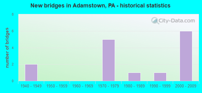
- New bridges - historical statistics
- 21940-1949
- 51970-1979
- 11980-1989
- 11990-1999
- 62000-2009


- Bridge Condition - Deck
- 16.7%Very good
- 16.7%Good
- 33.3%Satisfactory
- 33.3%Fair

- Bridge Condition - Superstructure
- 16.7%Very good
- 50.0%Good
- 33.3%Fair

- Bridge Condition - Substructure
- 66.7%Good
- 16.7%Fair
- 16.7%Poor

- Bridge Condition - Channel
- 14.3%Very good
- 14.3%Good
- 42.9%Satisfactory
- 14.3%Fair
- 14.3%Poor

- Bridge Condition - Culverts
- 66.7%Good
- 33.3%Fair
Find on map >> Show street view
Structure Number: 21122, Location: 0.25 mi.S. Berks Co. Line (Lat: 40.240819, Lng: -76.040711), Route carried "on" structure: State highway , Year Built: 1975, Year Reconstructed: 2020, Status: Open, Structure Length: 8.23m (27.00ft), Average Daily Traffic: 1,512 (year 2022), Truck Traffic: 10%, Average Future Daily Traffic: 1,782 (year 2040), Design Load: HS 20, Features Intersected: US 222; SR 0222, Facility Carried by Structure: SR 1088; T-874
Minimum Vertical Clearance: 30+ m (98+ ft), Kilometerpoint: 0.000, Lanes on structure: 2, Lanes under structure: 8, Owner: State Highway Agency, Approaching Roadway Width: 7.3m (24.0ft), Skew: 2 degrees, Material/Design: Steel continuous, Design/Construction: Stringer/Multi-beam, Number Of Spans In Main Unit: 2, Length of Maximum Span: 42.7m (140.1ft), Curb or Sidewalk Widths: Left: 0.2m (0.7ft), Right: 0.2m (0.7ft), Curb-To-Curb Width: 10.4m (34.1ft), Out-to-Out Width: 11.6m (38.1ft)
Condition: Deck: Very good, Superstructure: Good, Substructure: Good, Operating Rating: 79.8 metric tons, Method Used To Determine Operating Rating: Load Factor (LF), Inventory Rating: 47.2 metric tons, Method Used To Determine Inventory Rating: Load Factor (LF), Structural Evaluation: Better than present minimum criteria, Deck Geometry: Equal to present minimum criteria, Underclear: High priority of corrective action, Approach Roadway Alignment: Equal to present desirable criteria, Length Of Structure Improvement: 9.20m (30.18ft), Designated Inspection Frequency: Every 24 months, Inspection Date: November 2020, Bridge Improvement Cost: $25,000, Roadway Improvement Cost: $74,000, Total Project Cost: $339,000, Deck Structure Type: Concrete Cast-file-Place, Wearing Surface/Protective System: Wearing Surface: Monolithic Concrete, Deck Protection: Epoxy Coated Reinforcing
Find on map >> Show street view
Structure Number: 2116, Location: ADAMSTOWN BORO (Lat: 40.241453, Lng: -76.056392), Route carried "on" structure: State highway 272, Year Built: 1941, Status: Open, Structure Length: 2.04m (6.69ft), Average Daily Traffic: 9,643 (year 2020), Truck Traffic: 7%, Average Future Daily Traffic: 9,966 (year 2032), Design Load: HS 20, Features Intersected: LITTLE MUDDY CREEK
Minimum Vertical Clearance: 30+ m (98+ ft), Kilometerpoint: 66.474, Lanes on structure: 2, Base Highway Network: Yes, Owner: State Highway Agency, Approaching Roadway Width: 12.2m (40.0ft), Skew: 3 degrees, Material/Design: Concrete, Design/Construction: Tee Beam, Number Of Spans In Main Unit: 2, Length of Maximum Span: 9.1m (29.9ft), Curb or Sidewalk Widths: Left: 0.2m (0.7ft), Right: 0.2m (0.7ft), Curb-To-Curb Width: 9.4m (30.8ft), Out-to-Out Width: 10.2m (33.5ft)
Condition: Deck: Fair, Superstructure: Fair, Substructure: Fair, Channel: Satisfactory, Operating Rating: 46.3 metric tons, Method Used To Determine Operating Rating: Load Factor (LF), Inventory Rating: 27.2 metric tons, Method Used To Determine Inventory Rating: Load Factor (LF), Structural Evaluation: Somewhat better than minimum adequacy, Deck Geometry: High priority of corrective action, Waterway Adequacy: Equal to present minimum criteria, Approach Roadway Alignment: Equal to present desirable criteria, Length Of Structure Improvement: 2.70m (8.86ft), Designated Inspection Frequency: Every 24 months, Inspection Date: December 2020, Bridge Improvement Cost: $75,000, Roadway Improvement Cost: $221,000, Total Project Cost: $1,013,000, Deck Structure Type: Concrete Cast-file-Place, Wearing Surface/Protective System: Wearing Surface: Bituminous, Membrane: Preformed Fabric
Find on map >> Show street view
Structure Number: 21161, Location: ADAMSTOWN BORO (Lat: 40.244686, Lng: -76.047219), Route carried "on" structure: State highway 272, Year Built: 1941, Status: Open, Structure Length: 1.71m (5.61ft), Average Daily Traffic: 9,643 (year 2020), Truck Traffic: 7%, Average Future Daily Traffic: 9,966 (year 2032), Design Load: HS 20, Features Intersected: LITTLE MUDDY CREEK
Minimum Vertical Clearance: 30+ m (98+ ft), Kilometerpoint: 66.474, Lanes on structure: 2, Base Highway Network: Yes, Owner: State Highway Agency, Approaching Roadway Width: 12.2m (40.0ft), Skew: 4 degrees, Material/Design: Concrete, Design/Construction: Tee Beam, Number Of Spans In Main Unit: 2, Length of Maximum Span: 7.3m (24.0ft), Curb or Sidewalk Widths: Left: 0.2m (0.7ft), Right: 0.2m (0.7ft), Curb-To-Curb Width: 9.4m (30.8ft), Out-to-Out Width: 10.2m (33.5ft)
Condition: Deck: Fair, Superstructure: Fair, Substructure: Poor, Channel: Fair, Operating Rating: 54.4 metric tons, Method Used To Determine Operating Rating: Load Factor (LF), Inventory Rating: 32.7 metric tons, Method Used To Determine Inventory Rating: Load Factor (LF), Structural Evaluation: Meets minimum limits, Deck Geometry: High priority of corrective action, Waterway Adequacy: Equal to present minimum criteria, Approach Roadway Alignment: Equal to present desirable criteria, Designated Inspection Frequency: Every 24 months, Inspection Date: November 2020, Deck Structure Type: Concrete Cast-file-Place, Wearing Surface/Protective System: Wearing Surface: Bituminous
Find on map >> Show street view
Structure Number: 22138, Location: 100 FT SOUTH OF SR 272 (Lat: 40.244825, Lng: -76.046189), Route carried "on" structure: City street , Year Built: 1985, Status: Open, Structure Length: 0.79m (2.59ft), Average Daily Traffic: 725 (year 2011), Truck Traffic: 15%, Average Future Daily Traffic: 970 (year 2031), Features Intersected: LITTLE MUDDY CREEK, Facility Carried by Structure: BOWMANSVILLE RD
Minimum Vertical Clearance: 30+ m (98+ ft), Kilometerpoint: 0.000, Lanes on structure: 2, Owner: City or Municipal Highway Agency, Maintenance Responsibility: Town or Township Highway Agency, Approaching Roadway Width: 6.4m (21.0ft), Skew: 1 degrees, Material/Design: Concrete, Design/Construction: Culvert, Number Of Spans In Main Unit: 2, Length of Maximum Span: 3.7m (12.1ft), Curb or Sidewalk Widths: Left: 0.2m (0.7ft), Right: 0.2m (0.7ft), Curb-To-Curb Width: 8.6m (28.2ft), Out-to-Out Width: 9.7m (31.8ft)
Condition: Channel: Poor, Culverts: Fair, Operating Rating: 49.0 metric tons, Method Used To Determine Operating Rating: Field evaluation and documented engineering judgment, Inventory Rating: 32.7 metric tons, Method Used To Determine Inventory Rating: Field evaluation and documented engineering judgment, Structural Evaluation: Somewhat better than minimum adequacy, Deck Geometry: Somewhat better than minimum adequacy, Waterway Adequacy: Better than present minimum criteria, Approach Roadway Alignment: Equal to present desirable criteria, Length Of Structure Improvement: 1.40m (4.59ft), Designated Inspection Frequency: Every 24 months, Inspection Date: June 2021, Wearing Surface/Protective System: Wearing Surface: Bituminous
Find on map >> Show street view
Structure Number: 39633, Location: S.End of Adamstown Boroug (Lat: 40.234217, Lng: -76.056953), Route carried "on" structure: State highway , Year Built: 1997, Status: Open, Structure Length: 1.31m (4.30ft), Average Daily Traffic: 1,784 (year 2022), Truck Traffic: 5%, Average Future Daily Traffic: 1,855 (year 2032), Design Load: HS 25 or greater, Features Intersected: Trib To Muddy Creek, Facility Carried by Structure: Willow Street
Minimum Vertical Clearance: 30+ m (98+ ft), Kilometerpoint: 1.115, Lanes on structure: 2, Owner: State Highway Agency, Approaching Roadway Width: 9.4m (30.8ft), Skew: 3 degrees, Material/Design: Prestressed concrete, Design/Construction: Box Beam or Girders - Single/Spread, Number Of Spans In Main Unit: 1, Length of Maximum Span: 12.5m (41.0ft), Curb or Sidewalk Widths: Left: 0.2m (0.7ft), Right: 0.2m (0.7ft), Curb-To-Curb Width: 9.7m (31.8ft), Out-to-Out Width: 10.8m (35.4ft)
Condition: Deck: Satisfactory, Superstructure: Good, Substructure: Good, Channel: Good, Operating Rating: 85.3 metric tons, Method Used To Determine Operating Rating: Load Factor (LF), Inventory Rating: 50.8 metric tons, Method Used To Determine Inventory Rating: Load Factor (LF), Structural Evaluation: Better than present minimum criteria, Deck Geometry: Somewhat better than minimum adequacy, Waterway Adequacy: Better than present minimum criteria, Approach Roadway Alignment: Equal to present desirable criteria, Length Of Structure Improvement: 2.00m (6.56ft), Designated Inspection Frequency: Every 24 months, Inspection Date: May 2020, Deck Structure Type: Concrete Cast-file-Place, Wearing Surface/Protective System: Wearing Surface: Monolithic Concrete, Deck Protection: Epoxy Coated Reinforcing
Find on map >> Show street view
Structure Number: 42433, Location: NE of Adamstown (Lat: 40.250344, Lng: -76.032922), Route carried "on" structure: City street , Year Built: 2004, Status: Open, Structure Length: 2.01m (6.59ft), Average Daily Traffic: 400 (year 2012), Average Future Daily Traffic: 450 (year 2022), Design Load: HS 25 or greater, Features Intersected: Trib. Little Muddy Creek, Facility Carried by Structure: Deer Creek Rd
Minimum Vertical Clearance: 30+ m (98+ ft), Kilometerpoint: 0.000, Lanes on structure: 2, Owner: Town or Township Highway Agency, Approaching Roadway Width: 11.9m (39.0ft), Skew: 3 degrees, Material/Design: Prestressed concrete, Design/Construction: Box Beam or Girders - Single/Spread, Number Of Spans In Main Unit: 1, Length of Maximum Span: 20.1m (65.9ft), Curb-To-Curb Width: 12.0m (39.4ft), Out-to-Out Width: 12.9m (42.3ft)
Condition: Deck: Satisfactory, Superstructure: Very good, Substructure: Good, Channel: Very good, Operating Rating: 77.1 metric tons, Method Used To Determine Operating Rating: Load Factor (LF), Inventory Rating: 42.6 metric tons, Method Used To Determine Inventory Rating: Load Factor (LF), Structural Evaluation: Better than present minimum criteria, Deck Geometry: Superior to present desirable criteria, Waterway Adequacy: Superior to present desirable criteria, Approach Roadway Alignment: Equal to present desirable criteria, Designated Inspection Frequency: Every 24 months, Inspection Date: December 2020, Deck Structure Type: Concrete Cast-file-Place, Wearing Surface/Protective System: Wearing Surface: Monolithic Concrete, Deck Protection: Epoxy Coated Reinforcing
Find on map >> Show street view
Structure Number: 42445, Location: RAMP C (Lat: 40.246986, Lng: -76.037597), Route carried "on" structure: Ramp State highway , Year Built: 2004, Status: Open, Structure Length: 0.79m (2.59ft), Average Daily Traffic: 1,182 (year 2022), Truck Traffic: 7%, Average Future Daily Traffic: 1,299 (year 2032), Design Load: HS 25 or greater, Features Intersected: TRIB LITTLE MUDDY CR, Facility Carried by Structure: RAMP C
Minimum Vertical Clearance: 30+ m (98+ ft), Kilometerpoint: 0.000, Lanes on structure: 1, Base Highway Network: Yes, Owner: State Highway Agency, Approaching Roadway Width: 3.7m (12.1ft), Skew: 4 degrees, Material/Design: Concrete, Design/Construction: Culvert, Number Of Spans In Main Unit: 1, Length of Maximum Span: 7.3m (24.0ft)
Condition: Channel: Satisfactory, Culverts: Good, Operating Rating: 63.5 metric tons, Method Used To Determine Operating Rating: Load and Resistance Factor (LRFR), Inventory Rating: 49.0 metric tons, Method Used To Determine Inventory Rating: Load and Resistance Factor (LRFR), Structural Evaluation: Better than present minimum criteria, Waterway Adequacy: Superior to present desirable criteria, Approach Roadway Alignment: Equal to present desirable criteria, Designated Inspection Frequency: Every 48 months, Inspection Date: November 2018
Find on map >> Show street view
Structure Number: 43488, Location: US 222 OVER SR 568 (Lat: 40.249072, Lng: -76.036739), Route carried "on" structure: US 222, Year Built: 2004, Status: Open, Structure Length: 2.41m (7.91ft), Average Daily Traffic: 55,295 (year 2022), Truck Traffic: 10%, Average Future Daily Traffic: 42,170 (year 2032), Design Load: HL 93, Features Intersected: SR 568
Minimum Vertical Clearance: 30+ m (98+ ft), Kilometerpoint: 0.650, Lanes on structure: 5, Lanes under structure: 2, Base Highway Network: Yes, Owner: State Highway Agency, Approaching Roadway Width: 118.3m (388.1ft), Skew: 31 degrees, Material/Design: Prestressed concrete, Design/Construction: Box Beam or Girders - Single/Spread, Number Of Spans In Main Unit: 1, Length of Maximum Span: 23.8m (78.1ft), Curb-To-Curb Width: 15.8m (51.8ft), Out-to-Out Width: 28.2m (92.5ft)
Condition: Deck: Good, Superstructure: Good, Substructure: Good, Operating Rating: 73.5 metric tons, Method Used To Determine Operating Rating: Load and Resistance Factor (LRFR), Inventory Rating: 42.6 metric tons, Method Used To Determine Inventory Rating: Load and Resistance Factor (LRFR), Structural Evaluation: Better than present minimum criteria, Deck Geometry: High priority of replacement, Underclear: Equal to present minimum criteria, Approach Roadway Alignment: Equal to present desirable criteria, Designated Inspection Frequency: Every 48 months, Inspection Date: September 2018, Deck Structure Type: Concrete Cast-file-Place, Wearing Surface/Protective System: Wearing Surface: Monolithic Concrete, Deck Protection: Epoxy Coated Reinforcing
Find on map >> Show street view
Structure Number: 4349, Location: SR568 OVER L.MUDDY CR. (Lat: 40.249106, Lng: -76.036333), Route carried "on" structure: State highway 568, Year Built: 2005, Status: Open, Structure Length: 0.67m (2.20ft), Average Daily Traffic: 3,818 (year 2020), Truck Traffic: 8%, Average Future Daily Traffic: 5,962 (year 2032), Design Load: HL 93, Features Intersected: LITTLE MUDDY CREEK
Minimum Vertical Clearance: 30+ m (98+ ft), Kilometerpoint: 0.000, Lanes on structure: 2, Owner: State Highway Agency, Approaching Roadway Width: 17.7m (58.1ft), Skew: 1 degrees, Material/Design: Concrete, Design/Construction: Culvert, Number Of Spans In Main Unit: 1, Length of Maximum Span: 6.7m (22.0ft)
Condition: Channel: Satisfactory, Culverts: Good, Operating Rating: 61.7 metric tons, Method Used To Determine Operating Rating: Load and Resistance Factor (LRFR), Inventory Rating: 47.2 metric tons, Method Used To Determine Inventory Rating: Load and Resistance Factor (LRFR), Structural Evaluation: Better than present minimum criteria, Waterway Adequacy: Better than present minimum criteria, Approach Roadway Alignment: Equal to present desirable criteria, Designated Inspection Frequency: Every 48 months, Inspection Date: October 2018
Find on map >> Show street view
Structure Number: 2112, Location: 0.75 MI.S. OF ADAMSTOWN (Lat: 40.227819, Lng: -76.054800), Route carried "under" structure: US 222, Year Built: 1975, Structure Length: 0. m, Average Daily Traffic: 18,462 (year 2022), Truck Traffic: 16%, Features Intersected: US 222; SR 0222, Facility Carried by Structure: SR 1086; T-965
Minimum Vertical Clearance: 4.65m (15.26ft), Kilometerpoint: 76.800, Lanes on structure: 2, Lanes under structure: 2, Material/Design: Steel continuous, Design/Construction: Stringer/Multi-beam, Length of Maximum Span: 36.9m (121.1ft)
Find on map >> Show street view
Structure Number: 2112, Location: 0.75 MI.S. OF ADAMSTOWN (Lat: 40.227819, Lng: -76.054800), Route carried "under" structure: US 222, Year Built: 1975, Structure Length: 0. m, Average Daily Traffic: 18,231 (year 2022), Truck Traffic: 15%, Features Intersected: US 222; SR 0222, Facility Carried by Structure: SR 1086; T-965
Minimum Vertical Clearance: 4.90m (16.08ft), Kilometerpoint: 76.830, Lanes on structure: 2, Lanes under structure: 2, Material/Design: Steel continuous, Design/Construction: Stringer/Multi-beam, Length of Maximum Span: 36.9m (121.1ft)
Find on map >> Show street view
Structure Number: 21122, Location: 0.25 mi.S. Berks Co. Line (Lat: 40.240819, Lng: -76.040711), Route carried "under" structure: US 222, Year Built: 1975, Structure Length: 0. m, Average Daily Traffic: 18,462 (year 2022), Truck Traffic: 16%, Features Intersected: US 222; SR 0222, Facility Carried by Structure: SR 1088; T-874
Minimum Vertical Clearance: 5.39m (17.68ft), Kilometerpoint: 79.046, Lanes on structure: 2, Lanes under structure: 4, Material/Design: Steel continuous, Design/Construction: Stringer/Multi-beam, Length of Maximum Span: 42.7m (140.1ft)
Find on map >> Show street view
Structure Number: 21122, Location: 0.25 mi.S. Berks Co. Line (Lat: 40.240819, Lng: -76.040711), Route carried "under" structure: US 222, Year Built: 1975, Structure Length: 0. m, Average Daily Traffic: 18,231 (year 2022), Truck Traffic: 15%, Features Intersected: US 222; SR 0222, Facility Carried by Structure: SR 1088; T-874
Minimum Vertical Clearance: 4.57m (14.99ft), Kilometerpoint: 79.020, Lanes on structure: 2, Lanes under structure: 4, Material/Design: Steel continuous, Design/Construction: Stringer/Multi-beam, Length of Maximum Span: 42.7m (140.1ft)
Find on map >> Show street view
Structure Number: 43488, Location: US 222 OVER SR 568 (Lat: 40.249072, Lng: -76.036739), Route carried "under" structure: State highway 568, Year Built: 2004, Structure Length: 0. m, Average Daily Traffic: 3,818 (year 2020), Truck Traffic: 8%, Features Intersected: SR 568, Facility Carried by Structure: SR 222
Minimum Vertical Clearance: 4.66m (15.29ft), Kilometerpoint: 0.000, Lanes on structure: 5, Lanes under structure: 2, Material/Design: Prestressed concrete, Design/Construction: Box Beam or Girders - Single/Spread, Length of Maximum Span: 23.8m (78.1ft)
Find on map >> Show street view
Structure Number: 43488, Location: US 222 OVER SR 568 (Lat: 40.249072, Lng: -76.036739), Route carried "under" structure: State highway 272, Year Built: 2004, Structure Length: 0. m, Average Daily Traffic: 9,643 (year 2020), Truck Traffic: 7%, Features Intersected: SR 568, Facility Carried by Structure: SR 222
Minimum Vertical Clearance: 4.66m (15.29ft), Kilometerpoint: 0.000, Lanes on structure: 5, Lanes under structure: 2, Material/Design: Prestressed concrete, Design/Construction: Box Beam or Girders - Single/Spread, Length of Maximum Span: 23.8m (78.1ft)