Bridge Statistics for Adams, New York (NY)
Condition, Traffic, Stress, Structural Evaluation, Project Costs
- National Bridge Inventory (NBI) Statistics
- 29Number of bridges
- 279ft / 85.3mTotal length
- $32,121,000Total costs
- 143,798Total average daily traffic
- 13,147Total average daily truck traffic
- National Bridge Inventory (NBI) Registered Bridges for Adams
- No street view available for this location
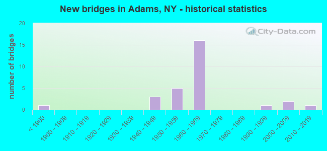
- New bridges - historical statistics
- 1Before 1900
- 31940-1949
- 51950-1959
- 161960-1969
- 11990-1999
- 22000-2009
- 12010-2019

- Reconstructed bridges - Historical Statistics
- 61980-1989
- 11990-1999


- Bridge Condition - Deck
- 11.8%Very good
- 17.6%Good
- 23.5%Satisfactory
- 41.2%Fair
- 5.9%Poor

- Bridge Condition - Superstructure
- 5.9%Excellent
- 5.9%Very good
- 11.8%Good
- 47.1%Satisfactory
- 29.4%Fair

- Bridge Condition - Substructure
- 5.9%Excellent
- 11.8%Very good
- 17.6%Good
- 5.9%Satisfactory
- 58.8%Fair

- Bridge Condition - Channel
- 27.3%Very good
- 36.4%Good
- 18.2%Satisfactory
- 18.2%Fair
Find on map >> Show street view
Structure Number: 100864, Location: 2.2 MI N JCT RT$ 11& 193 (Lat: 43.774644, Lng: -76.036694), Route carried "on" structure: US 11, Year Built: 1991, Status: Open, Structure Length: 6.13m (20.11ft), Average Daily Traffic: 1,866 (year 2020), Truck Traffic: 10%, Average Future Daily Traffic: 1,946 (year 2040), Design Load: HS 20, Features Intersected: SOUTH SANDY CREEK
Minimum Vertical Clearance: 30+ m (98+ ft), Kilometerpoint: 12.277, Lanes on structure: 2, Base Highway Network: Yes, Owner: State Highway Agency, Approaching Roadway Width: 11.0m (36.1ft), Material/Design: Prestressed concrete, Design/Construction: Box Beam or Girders - Single/Spread, Number Of Spans In Main Unit: 2, Length of Maximum Span: 26.8m (87.9ft), Curb-To-Curb Width: 11.0m (36.1ft), Out-to-Out Width: 11.6m (38.1ft)
Condition: Deck: Good, Superstructure: Very good, Substructure: Very good, Channel: Good, Inventory Rating: 32.7 metric tons, Method Used To Determine Inventory Rating: Allowable Stress (AS), Structural Evaluation: Equal to present desirable criteria, Deck Geometry: Equal to present minimum criteria, Waterway Adequacy: Somewhat better than minimum adequacy, Approach Roadway Alignment: Equal to present desirable criteria, Length Of Structure Improvement: 6.12m (20.08ft), Designated Inspection Frequency: Every 24 months, Inspection Date: May 2021, Bridge Improvement Cost: $1,038,000, Roadway Improvement Cost: $608,000, Total Project Cost: $1,645,000 ( Estimate for 2021), Deck Structure Type: Concrete Cast-file-Place, Wearing Surface/Protective System: Wearing Surface: Integral Concrete, Deck Protection: Epoxy Coated Reinforcing
Find on map >> Show street view
Structure Number: 100865, Location: .2 MI S JCT RTS 11 & 178 (Lat: 43.808408, Lng: -76.024342), Route carried "on" structure: US 11, Year Built: 1856, Status: Open, Structure Length: 1.52m (4.99ft), Average Daily Traffic: 3,963 (year 2020), Truck Traffic: 11%, Average Future Daily Traffic: 4,134 (year 2040), Design Load: H 20, Features Intersected: SANDY CREEK
Minimum Vertical Clearance: 30+ m (98+ ft), Kilometerpoint: 16.331, Lanes on structure: 2, Base Highway Network: Yes, Owner: State Highway Agency, Approaching Roadway Width: 14.3m (46.9ft), Material/Design: Masonry, Design/Construction: Arch - Deck, Number Of Spans In Main Unit: 1, Length of Maximum Span: 14.9m (48.9ft), Curb or Sidewalk Widths: Left: 1.8m (5.9ft), Right: 1.2m (3.9ft), Curb-To-Curb Width: 11.3m (37.1ft), Out-to-Out Width: 13.2m (43.3ft)
Condition: Deck: Very good, Superstructure: Fair, Substructure: Good, Channel: Good, Operating Rating: 54.3 metric tons, Method Used To Determine Operating Rating: Field evaluation and documented engineering judgment, Inventory Rating: 14.0 metric tons, Method Used To Determine Inventory Rating: Field evaluation and documented engineering judgment, Structural Evaluation: Meets minimum limits, Deck Geometry: Somewhat better than minimum adequacy, Waterway Adequacy: Equal to present minimum criteria, Approach Roadway Alignment: Equal to present desirable criteria, Length Of Structure Improvement: 1.52m (4.99ft), Designated Inspection Frequency: Every 24 months, Inspection Date: September 2020, Bridge Improvement Cost: $405,000, Roadway Improvement Cost: $237,000, Total Project Cost: $642,000 ( Estimate for 2021), Wearing Surface/Protective System: Wearing Surface: Bituminous
Find on map >> Show street view
Structure Number: 1032031, Location: 2.7 MI S JCT 178 + I-81 (Lat: 43.774467, Lng: -76.045942), Route carried "on" structure: Interstate 81, Year Built: 1961, Year Reconstructed: 1991, Status: Open, Structure Length: 9.05m (29.69ft), Average Daily Traffic: 9,336 (year 2009), Truck Traffic: 24%, Design Load: HS 20, Features Intersected: SOUTH SANDY CREEK
Minimum Vertical Clearance: 30+ m (98+ ft), Kilometerpoint: 12.228, Lanes on structure: 2, Base Highway Network: Yes, Owner: State Highway Agency, Approaching Roadway Width: 12.2m (40.0ft), Skew: 4 degrees, Material/Design: Steel, Design/Construction: Stringer/Multi-beam, Number Of Spans In Main Unit: 3, Length of Maximum Span: 34.4m (112.9ft), Curb-To-Curb Width: 9.8m (32.2ft), Out-to-Out Width: 10.4m (34.1ft)
Condition: Deck: Poor, Superstructure: Fair, Substructure: Fair, Channel: Satisfactory, Operating Rating: 78.9 metric tons, Method Used To Determine Operating Rating: Load Factor (LF), Inventory Rating: 47.2 metric tons, Method Used To Determine Inventory Rating: Load Factor (LF), Structural Evaluation: Somewhat better than minimum adequacy, Deck Geometry: Meets minimum limits, Waterway Adequacy: Superior to present desirable criteria, Approach Roadway Alignment: Equal to present desirable criteria, Length Of Structure Improvement: 9.05m (29.69ft), Designated Inspection Frequency: Every 24 months, Inspection Date: May 2021, Bridge Improvement Cost: $1,719,000, Roadway Improvement Cost: $1,007,000, Total Project Cost: $2,725,000 ( Estimate for 2021), Deck Structure Type: Concrete Cast-file-Place, Wearing Surface/Protective System: Wearing Surface: Integral Concrete, Deck Protection: Epoxy Coated Reinforcing
Find on map >> Show street view
Structure Number: 1032032, Location: 2.7 MI S JCT 178 + I-81 (Lat: 43.774803, Lng: -76.044339), Route carried "on" structure: Interstate 81, Year Built: 1961, Year Reconstructed: 1992, Status: Open, Structure Length: 9.05m (29.69ft), Average Daily Traffic: 4,311 (year 2019), Truck Traffic: 17%, Average Future Daily Traffic: 5,134 (year 2040), Design Load: HS 20, Features Intersected: SOUTH SANDY CREEK
Minimum Vertical Clearance: 30+ m (98+ ft), Kilometerpoint: 12.180, Lanes on structure: 2, Base Highway Network: Yes, Owner: State Highway Agency, Approaching Roadway Width: 9.8m (32.2ft), Skew: 4 degrees, Material/Design: Steel, Design/Construction: Stringer/Multi-beam, Number Of Spans In Main Unit: 3, Length of Maximum Span: 34.4m (112.9ft), Curb-To-Curb Width: 9.8m (32.2ft), Out-to-Out Width: 10.4m (34.1ft)
Condition: Deck: Fair, Superstructure: Fair, Substructure: Fair, Channel: Good, Operating Rating: 74.4 metric tons, Method Used To Determine Operating Rating: Load Factor (LF), Inventory Rating: 44.5 metric tons, Method Used To Determine Inventory Rating: Load Factor (LF), Structural Evaluation: Somewhat better than minimum adequacy, Deck Geometry: Meets minimum limits, Waterway Adequacy: Equal to present minimum criteria, Approach Roadway Alignment: Equal to present desirable criteria, Length Of Structure Improvement: 9.05m (29.69ft), Designated Inspection Frequency: Every 24 months, Inspection Date: May 2021, Bridge Improvement Cost: $1,719,000, Roadway Improvement Cost: $1,007,000, Total Project Cost: $2,725,000 ( Estimate for 2021), Deck Structure Type: Concrete Cast-file-Place, Wearing Surface/Protective System: Wearing Surface: Integral Concrete, Deck Protection: Epoxy Coated Reinforcing
Find on map >> Show street view
Structure Number: 103204, Location: 2.5 MI S JCT 178 + I-81 (Lat: 43.777106, Lng: -76.044344), Route carried "on" structure: County highway , Year Built: 1961, Status: Open, Structure Length: 4.15m (13.62ft), Average Daily Traffic: 296 (year 2015), Truck Traffic: 8%, Average Future Daily Traffic: 414 (year 2035), Design Load: HS 20, Features Intersected: RTE I81, Facility Carried by Structure: COUNTY ROAD 85
Minimum Vertical Clearance: 30+ m (98+ ft), Kilometerpoint: 6.516, Lanes on structure: 2, Lanes under structure: 2, Owner: State Highway Agency, Approaching Roadway Width: 7.0m (23.0ft), Skew: 2 degrees, Material/Design: Steel, Design/Construction: Stringer/Multi-beam, Number Of Spans In Main Unit: 3, Length of Maximum Span: 14.0m (45.9ft), Curb or Sidewalk Widths: Left: 0.5m (1.6ft), Right: 0.5m (1.6ft), Curb-To-Curb Width: 9.1m (29.9ft), Out-to-Out Width: 10.8m (35.4ft)
Condition: Deck: Satisfactory, Superstructure: Satisfactory, Substructure: Fair, Operating Rating: 75.3 metric tons, Method Used To Determine Operating Rating: Load Factor (LF), Inventory Rating: 44.5 metric tons, Method Used To Determine Inventory Rating: Load Factor (LF), Structural Evaluation: Somewhat better than minimum adequacy, Deck Geometry: Equal to present minimum criteria, Underclear: High priority of corrective action, Approach Roadway Alignment: Equal to present desirable criteria, Length Of Structure Improvement: 4.14m (13.58ft), Designated Inspection Frequency: Every 24 months, Inspection Date: May 2021, Bridge Improvement Cost: $845,000, Roadway Improvement Cost: $495,000, Total Project Cost: $1,340,000 ( Estimate for 2021), Deck Structure Type: Concrete Cast-file-Place, Wearing Surface/Protective System: Wearing Surface: Bituminous, Membrane: Other
Find on map >> Show street view
Structure Number: 103205, Location: 1.4 MI S JCT 178 + I-81 (Lat: 43.793236, Lng: -76.041986), Route carried "on" structure: Other road , Year Built: 1961, Status: Open, Structure Length: 4.45m (14.60ft), Average Daily Traffic: 137 (year 2017), Truck Traffic: 7%, Average Future Daily Traffic: 192 (year 2037), Design Load: HS 20, Features Intersected: RTE I81, Facility Carried by Structure: IKEY'S XING ROAD
Minimum Vertical Clearance: 30+ m (98+ ft), Kilometerpoint: 2.832, Lanes on structure: 2, Lanes under structure: 2, Owner: State Highway Agency, Approaching Roadway Width: 9.1m (29.9ft), Skew: 3 degrees, Material/Design: Steel, Design/Construction: Stringer/Multi-beam, Number Of Spans In Main Unit: 3, Length of Maximum Span: 15.5m (50.9ft), Curb or Sidewalk Widths: Left: 0.8m (2.6ft), Right: 0.8m (2.6ft), Curb-To-Curb Width: 9.1m (29.9ft), Out-to-Out Width: 10.8m (35.4ft)
Condition: Deck: Satisfactory, Superstructure: Satisfactory, Substructure: Fair, Operating Rating: 51.7 metric tons, Method Used To Determine Operating Rating: Load Factor (LF), Inventory Rating: 30.8 metric tons, Method Used To Determine Inventory Rating: Load Factor (LF), Structural Evaluation: Somewhat better than minimum adequacy, Deck Geometry: Equal to present minimum criteria, Underclear: High priority of corrective action, Approach Roadway Alignment: Equal to present desirable criteria, Length Of Structure Improvement: 4.45m (14.60ft), Designated Inspection Frequency: Every 24 months, Inspection Date: May 2021, Bridge Improvement Cost: $933,000, Roadway Improvement Cost: $546,000, Total Project Cost: $1,480,000 ( Estimate for 2021), Deck Structure Type: Concrete Cast-file-Place, Wearing Surface/Protective System: Wearing Surface: Bituminous, Membrane: Other
Find on map >> Show street view
Structure Number: 1032061, Location: .3 MI S JCT SH 178 & I81 (Lat: 43.807922, Lng: -76.036469), Route carried "on" structure: Interstate 81, Year Built: 1961, Status: Open, Structure Length: 1.49m (4.89ft), Average Daily Traffic: 9,336 (year 2009), Truck Traffic: 24%, Design Load: HS 20, Features Intersected: LIBERTY STREET CR-84 -W
Minimum Vertical Clearance: 30+ m (98+ ft), Kilometerpoint: 15.961, Lanes on structure: 2, Lanes under structure: 3, Base Highway Network: Yes, Owner: State Highway Agency, Approaching Roadway Width: 11.0m (36.1ft), Skew: 1 degrees, Material/Design: Concrete, Design/Construction: Frame, Number Of Spans In Main Unit: 1, Length of Maximum Span: 14.6m (47.9ft), Curb-To-Curb Width: 11.7m (38.4ft), Out-to-Out Width: 14.0m (45.9ft)
Condition: Deck: Satisfactory, Superstructure: Satisfactory, Substructure: Good, Inventory Rating: 63.5 metric tons, Method Used To Determine Inventory Rating: Load Factor (LF), Structural Evaluation: Equal to present minimum criteria, Deck Geometry: Equal to present minimum criteria, Underclear: Meets minimum limits, Approach Roadway Alignment: Equal to present desirable criteria, Length Of Structure Improvement: 1.49m (4.89ft), Designated Inspection Frequency: Every 24 months, Inspection Date: May 2020, Bridge Improvement Cost: $923,000, Roadway Improvement Cost: $541,000, Total Project Cost: $1,464,000 ( Estimate for 2021), Wearing Surface/Protective System: Wearing Surface: Bituminous
Find on map >> Show street view
Structure Number: 1032062, Location: .3 MI S JCT SH 178 & I81 (Lat: 43.807914, Lng: -76.035972), Route carried "on" structure: Interstate 81, Year Built: 1961, Status: Open, Structure Length: 1.49m (4.89ft), Average Daily Traffic: 4,311 (year 2019), Truck Traffic: 17%, Average Future Daily Traffic: 5,134 (year 2040), Design Load: HS 20, Features Intersected: LIBERTY STREET CR-84_WB
Minimum Vertical Clearance: 30+ m (98+ ft), Kilometerpoint: 15.961, Lanes on structure: 2, Lanes under structure: 4, Base Highway Network: Yes, Owner: State Highway Agency, Approaching Roadway Width: 11.0m (36.1ft), Skew: 1 degrees, Material/Design: Concrete, Design/Construction: Frame, Number Of Spans In Main Unit: 1, Length of Maximum Span: 14.6m (47.9ft), Curb-To-Curb Width: 11.8m (38.7ft), Out-to-Out Width: 14.0m (45.9ft)
Condition: Deck: Satisfactory, Superstructure: Satisfactory, Substructure: Good, Operating Rating: 93.4 metric tons, Method Used To Determine Operating Rating: Load Factor (LF), Inventory Rating: 56.2 metric tons, Method Used To Determine Inventory Rating: Load Factor (LF), Structural Evaluation: Equal to present minimum criteria, Deck Geometry: Equal to present minimum criteria, Underclear: Meets minimum limits, Approach Roadway Alignment: Equal to present desirable criteria, Length Of Structure Improvement: 1.49m (4.89ft), Designated Inspection Frequency: Every 24 months, Inspection Date: May 2020, Bridge Improvement Cost: $923,000, Roadway Improvement Cost: $541,000, Total Project Cost: $1,464,000 ( Estimate for 2021), Wearing Surface/Protective System: Wearing Surface: Bituminous
Find on map >> Show street view
Structure Number: 1032071, Location: 0.1 MI S JCT 178 + I-81 (Lat: 43.810203, Lng: -76.035375), Route carried "on" structure: Interstate 81, Year Built: 1961, Year Reconstructed: 1991, Status: Open, Structure Length: 8.14m (26.71ft), Average Daily Traffic: 9,336 (year 2009), Truck Traffic: 24%, Design Load: HS 20, Features Intersected: SANDY CREEK
Minimum Vertical Clearance: 30+ m (98+ ft), Kilometerpoint: 16.203, Lanes on structure: 2, Base Highway Network: Yes, Owner: State Highway Agency, Approaching Roadway Width: 9.8m (32.2ft), Skew: 1 degrees, Material/Design: Steel, Design/Construction: Stringer/Multi-beam, Number Of Spans In Main Unit: 3, Length of Maximum Span: 31.1m (102.0ft), Curb-To-Curb Width: 9.8m (32.2ft), Out-to-Out Width: 10.4m (34.1ft)
Condition: Deck: Fair, Superstructure: Satisfactory, Substructure: Fair, Channel: Very good, Operating Rating: 62.6 metric tons, Method Used To Determine Operating Rating: Load Factor (LF), Inventory Rating: 38.1 metric tons, Method Used To Determine Inventory Rating: Load Factor (LF), Structural Evaluation: Somewhat better than minimum adequacy, Deck Geometry: Meets minimum limits, Waterway Adequacy: Equal to present minimum criteria, Approach Roadway Alignment: Equal to present desirable criteria, Length Of Structure Improvement: 8.13m (26.67ft), Designated Inspection Frequency: Every 24 months, Inspection Date: May 2021, Bridge Improvement Cost: $1,523,000, Roadway Improvement Cost: $892,000, Total Project Cost: $2,416,000 ( Estimate for 2021), Deck Structure Type: Concrete Cast-file-Place, Wearing Surface/Protective System: Wearing Surface: Integral Concrete, Deck Protection: Epoxy Coated Reinforcing
Find on map >> Show street view
Structure Number: 1032072, Location: 0.1 MI S JCT 178 + I-81 (Lat: 43.810147, Lng: -76.034900), Route carried "on" structure: Interstate 81, Year Built: 1961, Year Reconstructed: 1991, Status: Open, Structure Length: 8.14m (26.71ft), Average Daily Traffic: 4,311 (year 2019), Truck Traffic: 17%, Average Future Daily Traffic: 5,134 (year 2040), Design Load: HS 20, Features Intersected: SANDY CREEK
Minimum Vertical Clearance: 30+ m (98+ ft), Kilometerpoint: 16.203, Lanes on structure: 2, Base Highway Network: Yes, Owner: State Highway Agency, Approaching Roadway Width: 11.6m (38.1ft), Skew: 1 degrees, Material/Design: Steel, Design/Construction: Stringer/Multi-beam, Number Of Spans In Main Unit: 3, Length of Maximum Span: 31.1m (102.0ft), Curb-To-Curb Width: 9.8m (32.2ft), Out-to-Out Width: 10.4m (34.1ft)
Condition: Deck: Fair, Superstructure: Satisfactory, Substructure: Fair, Channel: Good, Operating Rating: 62.6 metric tons, Method Used To Determine Operating Rating: Load Factor (LF), Inventory Rating: 38.1 metric tons, Method Used To Determine Inventory Rating: Load Factor (LF), Structural Evaluation: Somewhat better than minimum adequacy, Deck Geometry: Meets minimum limits, Waterway Adequacy: High priority of corrective action, Approach Roadway Alignment: Equal to present desirable criteria, Length Of Structure Improvement: 8.13m (26.67ft), Designated Inspection Frequency: Every 24 months, Inspection Date: May 2021, Bridge Improvement Cost: $1,523,000, Roadway Improvement Cost: $892,000, Total Project Cost: $2,416,000 ( Estimate for 2021), Deck Structure Type: Concrete Cast-file-Place, Wearing Surface/Protective System: Wearing Surface: Integral Concrete, Deck Protection: Epoxy Coated Reinforcing
Find on map >> Show street view
Structure Number: 1032081, Location: JCT OF RTS 178 + I-81 SB (Lat: 43.811144, Lng: -76.034917), Route carried "on" structure: Interstate 81, Year Built: 1959, Year Reconstructed: 1991, Status: Open, Structure Length: 3.93m (12.89ft), Average Daily Traffic: 9,583 (year 2013), Truck Traffic: 24%, Design Load: HS 20, Features Intersected: RTE 178
Minimum Vertical Clearance: 30+ m (98+ ft), Kilometerpoint: 16.315, Lanes on structure: 2, Lanes under structure: 2, Base Highway Network: Yes, Owner: State Highway Agency, Approaching Roadway Width: 9.8m (32.2ft), Material/Design: Steel, Design/Construction: Stringer/Multi-beam, Number Of Spans In Main Unit: 3, Length of Maximum Span: 14.6m (47.9ft), Curb-To-Curb Width: 9.8m (32.2ft), Out-to-Out Width: 10.7m (35.1ft)
Condition: Deck: Fair, Superstructure: Satisfactory, Substructure: Fair, Operating Rating: 72.3 metric tons, Method Used To Determine Operating Rating: Load and Resistance Factor Rating (LRFR) rating reported by rating factor(RF) method using HL-93 loadings, Inventory Rating: 55.7 metric tons, Method Used To Determine Inventory Rating: Load and Resistance Factor Rating (LRFR) rating reported by rating factor(RF) method using HL-93 loadings, Structural Evaluation: Somewhat better than minimum adequacy, Deck Geometry: High priority of replacement, Underclear: Meets minimum limits, Approach Roadway Alignment: Equal to present desirable criteria, Length Of Structure Improvement: 3.93m (12.89ft), Designated Inspection Frequency: Every 24 months, Inspection Date: May 2021, Bridge Improvement Cost: $846,000, Roadway Improvement Cost: $495,000, Total Project Cost: $1,341,000 ( Estimate for 2021), Deck Structure Type: Concrete Cast-file-Place, Wearing Surface/Protective System: Wearing Surface: Integral Concrete, Deck Protection: Epoxy Coated Reinforcing
Find on map >> Show street view
Structure Number: 1032082, Location: JCT OF RTS 178 + I-81 NB (Lat: 43.811031, Lng: -76.034483), Route carried "on" structure: Interstate 81, Year Built: 1959, Year Reconstructed: 1991, Status: Open, Structure Length: 3.93m (12.89ft), Average Daily Traffic: 4,311 (year 2019), Truck Traffic: 20%, Average Future Daily Traffic: 5,134 (year 2040), Design Load: HS 20, Features Intersected: RTE 178
Minimum Vertical Clearance: 30+ m (98+ ft), Kilometerpoint: 16.315, Lanes on structure: 2, Lanes under structure: 2, Base Highway Network: Yes, Owner: State Highway Agency, Approaching Roadway Width: 11.6m (38.1ft), Material/Design: Steel, Design/Construction: Stringer/Multi-beam, Number Of Spans In Main Unit: 3, Length of Maximum Span: 14.6m (47.9ft), Curb-To-Curb Width: 9.8m (32.2ft), Out-to-Out Width: 10.7m (35.1ft)
Condition: Deck: Fair, Superstructure: Good, Substructure: Fair, Operating Rating: 80.7 metric tons, Method Used To Determine Operating Rating: Load Factor (LF), Inventory Rating: 48.1 metric tons, Method Used To Determine Inventory Rating: Load Factor (LF), Structural Evaluation: Somewhat better than minimum adequacy, Deck Geometry: High priority of replacement, Underclear: Meets minimum limits, Approach Roadway Alignment: Equal to present desirable criteria, Length Of Structure Improvement: 3.93m (12.89ft), Designated Inspection Frequency: Every 24 months, Inspection Date: May 2021, Bridge Improvement Cost: $824,000, Roadway Improvement Cost: $482,000, Total Project Cost: $1,306,000 ( Estimate for 2021), Deck Structure Type: Concrete Cast-file-Place, Wearing Surface/Protective System: Wearing Surface: Integral Concrete, Deck Protection: Epoxy Coated Reinforcing
Find on map >> Show street view
Structure Number: 107362, Location: 0.1 MI E OF SR178 & I-81 (Lat: 43.811558, Lng: -76.031758), Route carried "on" structure: Ramp State highway , Year Built: 1959, Status: Open, Structure Length: 0.70m (2.30ft), Average Daily Traffic: 650 (year 2016), Truck Traffic: 38%, Average Future Daily Traffic: 774 (year 2040), Features Intersected: BROWN BROOK, Facility Carried by Structure: I-81 NB ramps to N
Minimum Vertical Clearance: 30+ m (98+ ft), Kilometerpoint: 0.113, Lanes on structure: 2, Owner: State Highway Agency, Approaching Roadway Width: 17.7m (58.1ft), Skew: 24 degrees, Material/Design: Steel, Design/Construction: Culvert, Number Of Spans In Main Unit: 2, Length of Maximum Span: 2.7m (8.9ft)
Condition: Channel: Fair, Culverts: Satisfactory, Operating Rating: 74.5 metric tons, Method Used To Determine Operating Rating: Field evaluation and documented engineering judgment, Inventory Rating: 32.7 metric tons, Method Used To Determine Inventory Rating: Field evaluation and documented engineering judgment, Structural Evaluation: Equal to present minimum criteria, Waterway Adequacy: Meets minimum limits, Approach Roadway Alignment: Equal to present desirable criteria, Length Of Structure Improvement: 0.70m (2.30ft), Designated Inspection Frequency: Every 24 months, Inspection Date: June 2021, Bridge Improvement Cost: $248,000, Roadway Improvement Cost: $145,000, Total Project Cost: $393,000 ( Estimate for 2021)
Find on map >> Show street view
Structure Number: 109488, Location: 2.5 MI S JCT SH 178 & I81 (Lat: 43.777247, Lng: -76.042878), Route carried "on" structure: County highway , Year Built: 1961, Status: Open, Structure Length: 4.15m (13.62ft), Average Daily Traffic: 296 (year 2015), Truck Traffic: 8%, Average Future Daily Traffic: 414 (year 2035), Design Load: HS 20, Features Intersected: RTE I81, Facility Carried by Structure: COUNTY ROAD 85
Minimum Vertical Clearance: 30+ m (98+ ft), Kilometerpoint: 6.645, Lanes on structure: 2, Lanes under structure: 2, Owner: State Highway Agency, Approaching Roadway Width: 9.1m (29.9ft), Skew: 2 degrees, Material/Design: Steel, Design/Construction: Stringer/Multi-beam, Number Of Spans In Main Unit: 3, Length of Maximum Span: 14.0m (45.9ft), Curb-To-Curb Width: 9.1m (29.9ft), Out-to-Out Width: 10.7m (35.1ft)
Condition: Deck: Fair, Superstructure: Satisfactory, Substructure: Fair, Operating Rating: 72.6 metric tons, Method Used To Determine Operating Rating: Load Factor (LF), Inventory Rating: 43.5 metric tons, Method Used To Determine Inventory Rating: Load Factor (LF), Structural Evaluation: Somewhat better than minimum adequacy, Deck Geometry: Equal to present minimum criteria, Underclear: High priority of corrective action, Approach Roadway Alignment: Equal to present desirable criteria, Length Of Structure Improvement: 4.14m (13.58ft), Designated Inspection Frequency: Every 24 months, Inspection Date: May 2021, Bridge Improvement Cost: $842,000, Roadway Improvement Cost: $493,000, Total Project Cost: $1,334,000 ( Estimate for 2021), Deck Structure Type: Concrete Cast-file-Place, Wearing Surface/Protective System: Wearing Surface: Bituminous, Membrane: Other
Find on map >> Show street view
Structure Number: 109489, Location: 1.4 MI S JCT RTS 178+J-81 (Lat: 43.793708, Lng: -76.040692), Route carried "on" structure: Other road , Year Built: 1961, Status: Open, Structure Length: 4.48m (14.70ft), Average Daily Traffic: 137 (year 2017), Truck Traffic: 7%, Average Future Daily Traffic: 192 (year 2037), Design Load: HS 20, Features Intersected: RTE I81, Facility Carried by Structure: IKEY'S XING ROAD
Minimum Vertical Clearance: 30+ m (98+ ft), Kilometerpoint: 2.961, Lanes on structure: 2, Lanes under structure: 2, Owner: State Highway Agency, Approaching Roadway Width: 9.1m (29.9ft), Skew: 3 degrees, Material/Design: Steel, Design/Construction: Stringer/Multi-beam, Number Of Spans In Main Unit: 3, Length of Maximum Span: 15.5m (50.9ft), Curb or Sidewalk Widths: Left: 0.5m (1.6ft), Right: 0.5m (1.6ft), Curb-To-Curb Width: 9.1m (29.9ft), Out-to-Out Width: 10.7m (35.1ft)
Condition: Deck: Fair, Superstructure: Fair, Substructure: Satisfactory, Operating Rating: 74.4 metric tons, Method Used To Determine Operating Rating: Load Factor (LF), Inventory Rating: 44.5 metric tons, Method Used To Determine Inventory Rating: Load Factor (LF), Structural Evaluation: Somewhat better than minimum adequacy, Deck Geometry: Equal to present minimum criteria, Underclear: High priority of corrective action, Approach Roadway Alignment: Equal to present desirable criteria, Length Of Structure Improvement: 4.48m (14.70ft), Designated Inspection Frequency: Every 24 months, Inspection Date: May 2021, Bridge Improvement Cost: $884,000, Roadway Improvement Cost: $518,000, Total Project Cost: $1,402,000 ( Estimate for 2021), Deck Structure Type: Concrete Cast-file-Place, Wearing Surface/Protective System: Wearing Surface: Bituminous, Membrane: Other
Find on map >> Show street view
Structure Number: 221996, Location: 1 MI E OF ADAMS VILLAGE (Lat: 43.809014, Lng: -75.996219), Route carried "on" structure: Other road , Year Built: 2004, Status: Open, Structure Length: 0.64m (2.10ft), Average Daily Traffic: 165 (year 2017), Truck Traffic: 7%, Average Future Daily Traffic: 231 (year 2037), Design Load: HS 25 or greater, Features Intersected: MIKEN BROOK, Facility Carried by Structure: LAWRENCE ROAD
Minimum Vertical Clearance: 30+ m (98+ ft), Kilometerpoint: 1.078, Lanes on structure: 2, Owner: Town or Township Highway Agency, Approaching Roadway Width: 7.6m (24.9ft), Material/Design: Concrete, Design/Construction: Culvert, Number Of Spans In Main Unit: 1, Length of Maximum Span: 6.0m (19.7ft), Curb-To-Curb Width: 8.8m (28.9ft), Out-to-Out Width: 9.8m (32.2ft)
Condition: Channel: Fair, Culverts: Satisfactory, Operating Rating: 76.9 metric tons, Method Used To Determine Operating Rating: Field evaluation and documented engineering judgment, Inventory Rating: 40.8 metric tons, Method Used To Determine Inventory Rating: Field evaluation and documented engineering judgment, Structural Evaluation: Equal to present minimum criteria, Deck Geometry: Equal to present minimum criteria, Waterway Adequacy: Meets minimum limits, Approach Roadway Alignment: Equal to present minimum criteria, Length Of Structure Improvement: 0.64m (2.10ft), Designated Inspection Frequency: Every 24 months, Inspection Date: September 2020, Bridge Improvement Cost: $125,000, Roadway Improvement Cost: $73,000, Total Project Cost: $198,000 ( Estimate for 2021)
Find on map >> Show street view
Structure Number: 333866, Location: 2 MILES WEST OF ADAMS (Lat: 43.813142, Lng: -76.074683), Route carried "on" structure: County highway , Year Built: 2001, Status: Open, Structure Length: 2.90m (9.51ft), Average Daily Traffic: 406 (year 2020), Truck Traffic: 9%, Average Future Daily Traffic: 568 (year 2040), Design Load: HS 25 or greater, Features Intersected: SANDY CREEK, Facility Carried by Structure: LIBERTY STREET
Minimum Vertical Clearance: 30+ m (98+ ft), Kilometerpoint: 0.080, Lanes on structure: 2, Owner: County Highway Agency, Approaching Roadway Width: 8.5m (27.9ft), Skew: 1 degrees, Material/Design: Steel, Design/Construction: Stringer/Multi-beam, Number Of Spans In Main Unit: 1, Length of Maximum Span: 27.4m (89.9ft), Curb-To-Curb Width: 8.5m (27.9ft), Out-to-Out Width: 9.1m (29.9ft)
Condition: Deck: Good, Superstructure: Good, Substructure: Very good, Channel: Satisfactory, Operating Rating: 56.2 metric tons, Method Used To Determine Operating Rating: Load Factor (LF), Inventory Rating: 36.3 metric tons, Method Used To Determine Inventory Rating: Load Factor (LF), Structural Evaluation: Better than present minimum criteria, Deck Geometry: Somewhat better than minimum adequacy, Waterway Adequacy: Equal to present minimum criteria, Approach Roadway Alignment: Equal to present desirable criteria, Length Of Structure Improvement: 2.89m (9.48ft), Designated Inspection Frequency: Every 24 months, Inspection Date: October 2021, Bridge Improvement Cost: $696,000, Roadway Improvement Cost: $408,000, Total Project Cost: $1,104,000 ( Estimate for 2021), Deck Structure Type: Concrete Cast-file-Place, Wearing Surface/Protective System: Wearing Surface: Integral Concrete
Find on map >> Show street view
Structure Number: 333867, Location: 0.2 MI.N.OF ADAMS (Lat: 43.807278, Lng: -76.019467), Route carried "on" structure: Other road , Year Built: 1942, Year Reconstructed: 1998, Status: Open, Structure Length: 5.79m (19.00ft), Average Daily Traffic: 475 (year 2017), Truck Traffic: 3%, Average Future Daily Traffic: 665 (year 2037), Features Intersected: SANDY CREEK, Facility Carried by Structure: SOUTH PARK STREET
Minimum Vertical Clearance: 30+ m (98+ ft), Kilometerpoint: 0.064, Lanes on structure: 2, Owner: County Highway Agency, Approaching Roadway Width: 5.5m (18.0ft), Skew: 4 degrees, Material/Design: Steel, Design/Construction: Truss - Thru, Number Of Spans In Main Unit: 2, Length of Maximum Span: 27.7m (90.9ft), Curb or Sidewalk Widths: Left: 1.6m (5.2ft), Right: 0.0m, Curb-To-Curb Width: 6.5m (21.3ft), Out-to-Out Width: 7.0m (23.0ft)
Condition: Deck: Good, Superstructure: Fair, Substructure: Fair, Channel: Very good, Operating Rating: 49.9 metric tons, Method Used To Determine Operating Rating: Load Factor (LF), Inventory Rating: 34.5 metric tons, Method Used To Determine Inventory Rating: Load Factor (LF), Structural Evaluation: Somewhat better than minimum adequacy, Deck Geometry: High priority of corrective action, Waterway Adequacy: Equal to present minimum criteria, Approach Roadway Alignment: Somewhat better than minimum adequacy, Length Of Structure Improvement: 5.79m (19.00ft), Designated Inspection Frequency: Every 24 months, Critical Feature Inspection Frequency: Every 24 months, Inspection Date: October 2020, Critical Feature Inspection Date: October 2020, Bridge Improvement Cost: $3,119,000, Roadway Improvement Cost: $1,827,000, Total Project Cost: $4,946,000 ( Estimate for 2021), Deck Structure Type: Wood or Timber, Wearing Surface/Protective System: Wearing Surface: Bituminous, Membrane: Other
Find on map >> Show street view
Structure Number: 333868, Location: 1 MILE NORTH OF ADAMS (Lat: 43.815875, Lng: -75.994975), Route carried "on" structure: County highway , Year Built: 2010, Status: Open, Structure Length: 5.18m (16.99ft), Average Daily Traffic: 858 (year 2019), Truck Traffic: 9%, Average Future Daily Traffic: 1,201 (year 2039), Design Load: HL 93, Features Intersected: SANDY CREEK, Facility Carried by Structure: Co Rd 69
Minimum Vertical Clearance: 30+ m (98+ ft), Kilometerpoint: 1.094, Lanes on structure: 2, Owner: County Highway Agency, Approaching Roadway Width: 9.4m (30.8ft), Skew: 3 degrees, Material/Design: Steel, Design/Construction: Stringer/Multi-beam, Number Of Spans In Main Unit: 1, Length of Maximum Span: 50.0m (164.0ft), Curb-To-Curb Width: 9.6m (31.5ft), Out-to-Out Width: 10.6m (34.8ft)
Condition: Deck: Very good, Superstructure: Excellent, Substructure: Excellent, Channel: Very good, Operating Rating: 74.5 metric tons, Method Used To Determine Operating Rating: Load and Resistance Factor Rating (LRFR) rating reported by rating factor(RF) method using HL-93 loadings, Inventory Rating: 57.7 metric tons, Method Used To Determine Inventory Rating: Load and Resistance Factor Rating (LRFR) rating reported by rating factor(RF) method using HL-93 loadings, Structural Evaluation: Superior to present desirable criteria, Deck Geometry: Equal to present minimum criteria, Waterway Adequacy: Equal to present minimum criteria, Approach Roadway Alignment: Equal to present desirable criteria, Length Of Structure Improvement: 5.18m (16.99ft), Designated Inspection Frequency: Every 24 months, Inspection Date: September 2020, Bridge Improvement Cost: $1,123,000, Roadway Improvement Cost: $657,000, Total Project Cost: $1,780,000 ( Estimate for 2021), Deck Structure Type: Concrete Cast-file-Place, Wearing Surface/Protective System: Wearing Surface: Integral Concrete, Deck Protection: Epoxy Coated Reinforcing
Find on map >> Show street view
Structure Number: 103204, Location: 2.5 MI S JCT 178 + I-81 (Lat: 43.777106, Lng: -76.044344), Route carried "under" structure: Interstate 81, Year Built: 1961, Structure Length: 0. m, Average Daily Traffic: 17,265 (year 1999), Features Intersected: RTE I81, Facility Carried by Structure: COUNTY ROAD 85
Minimum Vertical Clearance: 5.33m (17.49ft), Kilometerpoint: 12.550, Lanes on structure: 2, Lanes under structure: 2, Material/Design: Steel, Design/Construction: Stringer/Multi-beam, Length of Maximum Span: 14.0m (45.9ft)
Find on map >> Show street view
Structure Number: 103205, Location: 1.4 MI S JCT 178 + I-81 (Lat: 43.793236, Lng: -76.041986), Route carried "under" structure: Interstate 81, Year Built: 1961, Structure Length: 0. m, Average Daily Traffic: 17,265 (year 1999), Features Intersected: RTE I81, Facility Carried by Structure: IKEY'S XING ROAD
Minimum Vertical Clearance: 4.97m (16.31ft), Kilometerpoint: 14.320, Lanes on structure: 2, Lanes under structure: 2, Material/Design: Steel, Design/Construction: Stringer/Multi-beam, Length of Maximum Span: 15.5m (50.9ft)
Find on map >> Show street view
Structure Number: 1032061, Location: .3 MI S JCT SH 178 & I81 (Lat: 43.807922, Lng: -76.036469), Route carried "under" structure: County highway , Year Built: 1961, Structure Length: 0. m, Average Daily Traffic: 252 (year 2007), Features Intersected: LIBERTY STREET CR-84 -W, Facility Carried by Structure: RTE I81
Minimum Vertical Clearance: 4.44m (14.57ft), Kilometerpoint: 0.000, Lanes on structure: 2, Lanes under structure: 1, Material/Design: Concrete, Design/Construction: Frame, Length of Maximum Span: 14.6m (47.9ft)
Find on map >> Show street view
Structure Number: 1032062, Location: .3 MI S JCT SH 178 & I81 (Lat: 43.807914, Lng: -76.035972), Route carried "under" structure: County highway , Year Built: 1961, Structure Length: 0. m, Average Daily Traffic: 252 (year 2007), Features Intersected: LIBERTY STREET CR-84_WB, Facility Carried by Structure: RTE I81
Minimum Vertical Clearance: 4.44m (14.57ft), Kilometerpoint: 0.000, Lanes on structure: 2, Lanes under structure: 2, Material/Design: Concrete, Design/Construction: Frame, Length of Maximum Span: 14.6m (47.9ft)
Find on map >> Show street view
Structure Number: 1032081, Location: JCT OF RTS 178 + I-81 SB (Lat: 43.811144, Lng: -76.034917), Route carried "under" structure: State highway 178, Year Built: 1959, Structure Length: 0. m, Average Daily Traffic: 3,500 (year 1990), Features Intersected: RTE 178, Facility Carried by Structure: RTE I81
Minimum Vertical Clearance: 4.74m (15.55ft), Kilometerpoint: 17.635, Lanes on structure: 2, Lanes under structure: 2, Material/Design: Steel, Design/Construction: Stringer/Multi-beam, Length of Maximum Span: 14.6m (47.9ft)
Find on map >> Show street view
Structure Number: 1032082, Location: JCT OF RTS 178 + I-81 NB (Lat: 43.811031, Lng: -76.034483), Route carried "under" structure: State highway 178, Year Built: 1959, Structure Length: 0. m, Average Daily Traffic: 3,500 (year 1990), Features Intersected: RTE 178, Facility Carried by Structure: RTE I81
Minimum Vertical Clearance: 4.80m (15.75ft), Kilometerpoint: 17.651, Lanes on structure: 2, Lanes under structure: 2, Material/Design: Steel, Design/Construction: Stringer/Multi-beam, Length of Maximum Span: 14.6m (47.9ft)
Find on map >> Show street view
Structure Number: 109488, Location: 2.5 MI S JCT SH 178 & I81 (Lat: 43.777247, Lng: -76.042878), Route carried "under" structure: Interstate 81, Year Built: 1961, Structure Length: 0. m, Average Daily Traffic: 17,265 (year 1999), Features Intersected: RTE I81, Facility Carried by Structure: COUNTY ROAD 85
Minimum Vertical Clearance: 5.33m (17.49ft), Kilometerpoint: 12.389, Lanes on structure: 2, Lanes under structure: 2, Material/Design: Steel, Design/Construction: Stringer/Multi-beam, Length of Maximum Span: 14.0m (45.9ft)
Find on map >> Show street view
Structure Number: 109489, Location: 1.4 MI S JCT RTS 178+J-81 (Lat: 43.793708, Lng: -76.040692), Route carried "under" structure: Interstate 81, Year Built: 1961, Structure Length: 0. m, Average Daily Traffic: 17,265 (year 1999), Features Intersected: RTE I81, Facility Carried by Structure: IKEY'S XING ROAD
Minimum Vertical Clearance: 4.95m (16.24ft), Kilometerpoint: 17.522, Lanes on structure: 2, Lanes under structure: 2, Material/Design: Steel, Design/Construction: Stringer/Multi-beam, Length of Maximum Span: 15.5m (50.9ft)
Find on map >> Show street view
Structure Number: 70394, Location: .6 MILE E JCT SH178 & I81 (Lat: 43.810006, Lng: -76.028597), Route carried "under" structure: State highway 178, Year Built: 1940, Structure Length: 0. m, Average Daily Traffic: 3,150 (year 1979), Features Intersected: RTE 178, Facility Carried by Structure: CSX TRANSPRTATION
Minimum Vertical Clearance: 4.26m (13.98ft), Kilometerpoint: 0.000, Lanes under structure: 2, Material/Design: Steel, Design/Construction: Stringer/Multi-beam, Length of Maximum Span: 10.3m (33.8ft)
Find on map >> Show street view
Structure Number: 771576, Location: .25 MI W JCT RT11 & CR84 (Lat: 43.808700, Lng: -76.029469), Route carried "under" structure: County highway , Year Built: 1940, Structure Length: 0. m, Features Intersected: Liberty Street, Facility Carried by Structure: CSX Transportation
Minimum Vertical Clearance: 3.43m (11.25ft), Kilometerpoint: 0.000, Lanes under structure: 2, Material/Design: Steel, Design/Construction: Stringer/Multi-beam, Length of Maximum Span: 6.4m (21.0ft)