Bridge Statistics for Accident, Maryland (MD)
Condition, Traffic, Stress, Structural Evaluation, Project Costs
- National Bridge Inventory (NBI) Statistics
- 14Number of bridges
- 85ft / 25.8mTotal length
- $674,000Total costs
- 16,551Total average daily traffic
- 1,455Total average daily truck traffic
- National Bridge Inventory (NBI) Registered Bridges for Accident
- No street view available for this location
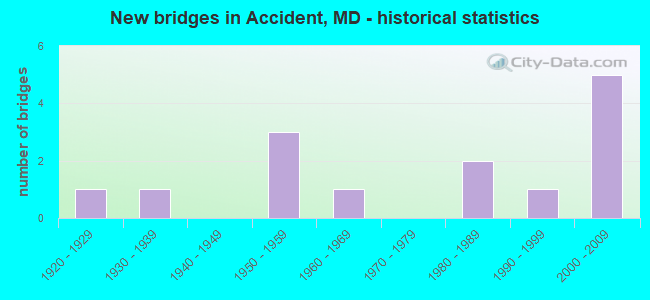
- New bridges - historical statistics
- 11920-1929
- 11930-1939
- 31950-1959
- 11960-1969
- 21980-1989
- 11990-1999
- 52000-2009

- Reconstructed bridges - Historical Statistics
- 11980-1989
- 01990-1999
- 02000-2009
- 12010-2019


- Bridge Condition - Deck
- 50.0%Good
- 50.0%Satisfactory

- Bridge Condition - Superstructure
- 9.1%Very good
- 45.5%Good
- 27.3%Satisfactory
- 18.2%Fair

- Bridge Condition - Substructure
- 9.1%Very good
- 54.5%Good
- 27.3%Satisfactory
- 9.1%Fair

- Bridge Condition - Channel
- 7.7%Very good
- 15.4%Good
- 46.2%Satisfactory
- 23.1%Fair
- 7.7%Poor
Find on map >> Show street view
Structure Number: 10000011002002, Location: .07 MILE NORTH OF MD 826P (Lat: 39.606253, Lng: -79.334236), Route carried "on" structure: US 219, Year Built: 1950, Status: Open, Structure Length: 1.03m (3.38ft), Average Daily Traffic: 3,900 (year 2013), Truck Traffic: 8%, Average Future Daily Traffic: 5,998 (year 2026), Design Load: H 20, Features Intersected: SOUTH BRANCH BEAR CREEK
Minimum Vertical Clearance: 30+ m (98+ ft), Kilometerpoint: 46.835, Lanes on structure: 2, Base Highway Network: Yes, Owner: State Highway Agency, Approaching Roadway Width: 12.8m (42.0ft), Skew: 4 degrees, Material/Design: Concrete, Design/Construction: Culvert, Length of Maximum Span: 4.9m (16.1ft)
Condition: Channel: Good, Culverts: Satisfactory, Operating Rating: 47.6 metric tons, Method Used To Determine Operating Rating: Load Factor (LF), Inventory Rating: 28.1 metric tons, Method Used To Determine Inventory Rating: Load Factor (LF), Structural Evaluation: Equal to present minimum criteria, Waterway Adequacy: Meets minimum limits, Approach Roadway Alignment: Equal to present desirable criteria, Designated Inspection Frequency: Every 24 months, Inspection Date: July 2021
Find on map >> Show street view
Structure Number: 10000011003002, Location: .44 MILE NORTH OF MD 826P (Lat: 39.611353, Lng: -79.332508), Route carried "on" structure: US 219, Year Built: 1950, Status: Open, Structure Length: 0.77m (2.53ft), Average Daily Traffic: 3,900 (year 2013), Truck Traffic: 8%, Average Future Daily Traffic: 5,998 (year 2026), Design Load: H 20, Features Intersected: SOUTH BRANCH BEAR CREEK
Minimum Vertical Clearance: 30+ m (98+ ft), Kilometerpoint: 47.433, Lanes on structure: 2, Base Highway Network: Yes, Owner: State Highway Agency, Approaching Roadway Width: 11.0m (36.1ft), Skew: 4 degrees, Material/Design: Concrete, Design/Construction: Culvert, Length of Maximum Span: 7.6m (24.9ft)
Condition: Channel: Fair, Culverts: Satisfactory, Operating Rating: 58.5 metric tons, Method Used To Determine Operating Rating: Load Factor (LF), Inventory Rating: 34.9 metric tons, Method Used To Determine Inventory Rating: Load Factor (LF), Structural Evaluation: Equal to present minimum criteria, Waterway Adequacy: Equal to present desirable criteria, Approach Roadway Alignment: Equal to present desirable criteria, Designated Inspection Frequency: Every 24 months, Inspection Date: July 2021
Find on map >> Show street view
Structure Number: 10000011003701, Location: .78 MILE NORTH OF US 219C (Lat: 39.651611, Lng: -79.300333), Route carried "on" structure: US 219, Year Built: 2000, Status: Open, Structure Length: 8.78m (28.81ft), Average Daily Traffic: 4,402 (year 2009), Truck Traffic: 14%, Average Future Daily Traffic: 4,972 (year 2026), Design Load: HS 25 or greater, Features Intersected: BEAR CR/FISH HATCHERY RD
Minimum Vertical Clearance: 30+ m (98+ ft), Kilometerpoint: 52.856, Lanes on structure: 2, Lanes under structure: 2, Base Highway Network: Yes, Owner: State Highway Agency, Approaching Roadway Width: 12.2m (40.0ft), Material/Design: Steel continuous, Design/Construction: Stringer/Multi-beam, Number Of Spans In Main Unit: 2, Length of Maximum Span: 45.1m (148.0ft), Curb or Sidewalk Widths: Left: 0.6m (2.0ft), Right: 0.6m (2.0ft), Curb-To-Curb Width: 12.2m (40.0ft), Out-to-Out Width: 13.4m (44.0ft)
Condition: Deck: Good, Superstructure: Good, Substructure: Good, Channel: Very good, Operating Rating: 77.1 metric tons, Method Used To Determine Operating Rating: Load Factor (LF), Inventory Rating: 46.3 metric tons, Method Used To Determine Inventory Rating: Load Factor (LF), Structural Evaluation: Better than present minimum criteria, Deck Geometry: Equal to present minimum criteria, Underclear: Meets minimum limits, Waterway Adequacy: Superior to present desirable criteria, Approach Roadway Alignment: Equal to present minimum criteria, Designated Inspection Frequency: Every 24 months, Inspection Date: July 2021, Deck Structure Type: Concrete Cast-file-Place, Wearing Surface/Protective System: Wearing Surface: Monolithic Concrete, Deck Protection: Epoxy Coated Reinforcing
Find on map >> Show street view
Structure Number: 200000G-008501, Location: 0.17 MI SE WALNUT ST (Lat: 39.660806, Lng: -79.396306), Route carried "on" structure: County highway 277, Year Built: 1921, Status: Open, Structure Length: 1.89m (6.20ft), Average Daily Traffic: 2,345 (year 2019), Truck Traffic: 5%, Average Future Daily Traffic: 2,865 (year 2039), Features Intersected: BEAR CREEK, Facility Carried by Structure: ACCIDENT BEAR CREE
Minimum Vertical Clearance: 30+ m (98+ ft), Kilometerpoint: 10.459, Lanes on structure: 2, Owner: County Highway Agency, Approaching Roadway Width: 6.1m (20.0ft), Material/Design: Concrete, Design/Construction: Arch - Deck, Number Of Spans In Main Unit: 1, Length of Maximum Span: 18.6m (61.0ft), Curb-To-Curb Width: 7.6m (24.9ft), Out-to-Out Width: 8.0m (26.2ft)
Condition: Superstructure: Fair, Substructure: Fair, Channel: Poor, Operating Rating: 32.7 metric tons, Method Used To Determine Operating Rating: Field evaluation and documented engineering judgment, Inventory Rating: 32.7 metric tons, Method Used To Determine Inventory Rating: Field evaluation and documented engineering judgment, Structural Evaluation: Somewhat better than minimum adequacy, Deck Geometry: High priority of replacement, Waterway Adequacy: Somewhat better than minimum adequacy, Approach Roadway Alignment: Equal to present minimum criteria, Length Of Structure Improvement: 3.66m (12.01ft), Designated Inspection Frequency: Every 24 months, Inspection Date: September 2021, Bridge Improvement Cost: $32,000, Total Project Cost: $32,000, Wearing Surface/Protective System: Wearing Surface: Bituminous
Find on map >> Show street view
Structure Number: 200000G-008601, Location: 0.01 MI S ACC FRNDVLLE RD (Lat: 39.655917, Lng: -79.390500), Route carried "on" structure: County highway 52, Year Built: 2002, Status: Open, Structure Length: 2.88m (9.45ft), Average Daily Traffic: 120 (year 2021), Truck Traffic: 5%, Average Future Daily Traffic: 140 (year 2041), Design Load: HS 20, Features Intersected: BEAR CREEK, Facility Carried by Structure: ACCIDENT FRIENDSVI
Minimum Vertical Clearance: 30+ m (98+ ft), Kilometerpoint: 0.016, Lanes on structure: 1, Owner: County Highway Agency, Approaching Roadway Width: 6.1m (20.0ft), Material/Design: Steel, Design/Construction: Truss - Thru, Number Of Spans In Main Unit: 1, Length of Maximum Span: 27.4m (89.9ft), Curb-To-Curb Width: 4.2m (13.8ft), Out-to-Out Width: 5.0m (16.4ft)
Condition: Deck: Satisfactory, Superstructure: Satisfactory, Substructure: Good, Channel: Good, Operating Rating: 39.0 metric tons, Method Used To Determine Operating Rating: Load Factor (LF), Inventory Rating: 23.6 metric tons, Method Used To Determine Inventory Rating: Load Factor (LF), Structural Evaluation: Equal to present minimum criteria, Deck Geometry: High priority of replacement, Waterway Adequacy: Meets minimum limits, Approach Roadway Alignment: High priority of corrective action, Length Of Structure Improvement: 2.80m (9.19ft), Designated Inspection Frequency: Every 24 months, Critical Feature Inspection Frequency: Every 24 months, Inspection Date: September 2021, Critical Feature Inspection Date: September 2021, Bridge Improvement Cost: $506,000, Roadway Improvement Cost: $20,000, Total Project Cost: $526,000, Deck Structure Type: Steel plate, Wearing Surface/Protective System: Wearing Surface: Other
Find on map >> Show street view
Structure Number: 200000G-008701, Location: 0.43 MI SE ACC BEAR CR RD (Lat: 39.652889, Lng: -79.384667), Route carried "on" structure: County highway 52, Year Built: 1984, Status: Posted for load, Structure Length: 1.95m (6.40ft), Average Daily Traffic: 146 (year 2021), Truck Traffic: 5%, Average Future Daily Traffic: 180 (year 2041), Features Intersected: SOUTH BRANCH OF BEAR CRE, Facility Carried by Structure: ACCIDENT-FRIENDSVI
Minimum Vertical Clearance: 30+ m (98+ ft), Kilometerpoint: 0.692, Lanes on structure: 2, Owner: County Highway Agency, Approaching Roadway Width: 4.9m (16.1ft), Material/Design: Steel, Design/Construction: Stringer/Multi-beam, Number Of Spans In Main Unit: 1, Length of Maximum Span: 17.7m (58.1ft), Curb-To-Curb Width: 5.5m (18.0ft), Out-to-Out Width: 6.0m (19.7ft)
Condition: Deck: Satisfactory, Superstructure: Fair, Substructure: Satisfactory, Channel: Fair, Operating Rating: 65.3 metric tons, Method Used To Determine Operating Rating: Load Factor (LF), Inventory Rating: 39.0 metric tons, Method Used To Determine Inventory Rating: Load Factor (LF), Structural Evaluation: Somewhat better than minimum adequacy, Deck Geometry: High priority of corrective action, Waterway Adequacy: Better than present minimum criteria, Approach Roadway Alignment: Equal to present minimum criteria, Length Of Structure Improvement: 2.13m (6.99ft), Designated Inspection Frequency: Every 24 months, Inspection Date: September 2021, Bridge Improvement Cost: $25,000, Roadway Improvement Cost: $25,000, Total Project Cost: $50,000, Deck Structure Type: Concrete Precast Panels, Wearing Surface/Protective System: Wearing Surface: Monolithic Concrete
Find on map >> Show street view
Structure Number: 200000G-008801, Location: 0.1 MI SW ACC BEAR CR RD (Lat: 39.655778, Lng: -79.338611), Route carried "on" structure: County highway 33, Year Built: 1935, Year Reconstructed: 1994, Status: Open, Structure Length: 1.28m (4.20ft), Average Daily Traffic: 27 (year 2021), Truck Traffic: 5%, Average Future Daily Traffic: 35 (year 2041), Features Intersected: BEAR CREEK, Facility Carried by Structure: ARTHUR DEVINE ROAD
Minimum Vertical Clearance: 30+ m (98+ ft), Kilometerpoint: 0.161, Lanes on structure: 1, Owner: County Highway Agency, Approaching Roadway Width: 3.7m (12.1ft), Material/Design: Prestressed concrete, Design/Construction: Box Beam or Girders - Multiple, Number Of Spans In Main Unit: 1, Length of Maximum Span: 11.0m (36.1ft), Curb-To-Curb Width: 3.7m (12.1ft), Out-to-Out Width: 3.7m (12.1ft)
Condition: Deck: Satisfactory, Superstructure: Satisfactory, Substructure: Satisfactory, Channel: Fair, Operating Rating: 32.7 metric tons, Method Used To Determine Operating Rating: Field evaluation and documented engineering judgment, Inventory Rating: 32.7 metric tons, Method Used To Determine Inventory Rating: Field evaluation and documented engineering judgment, Structural Evaluation: Equal to present minimum criteria, Deck Geometry: Meets minimum limits, Waterway Adequacy: Equal to present minimum criteria, Approach Roadway Alignment: Equal to present minimum criteria, Length Of Structure Improvement: 1.40m (4.59ft), Designated Inspection Frequency: Every 24 months, Inspection Date: November 2021, Bridge Improvement Cost: $31,000, Roadway Improvement Cost: $1,000, Total Project Cost: $32,000, Deck Structure Type: Other, Wearing Surface/Protective System: Wearing Surface: Monolithic Concrete
Find on map >> Show street view
Structure Number: 200000G-009001, Location: SOUTH OF US 40 (Lat: 39.600197, Lng: -79.250911), Route carried "on" structure: County highway 167, Year Built: 1988, Status: Posted for load, Structure Length: 1.04m (3.41ft), Average Daily Traffic: 100 (year 2021), Truck Traffic: 5%, Average Future Daily Traffic: 125 (year 2041), Features Intersected: NORTH BRANCH CASSELMAN R, Facility Carried by Structure: ORENDORF ROAD
Minimum Vertical Clearance: 30+ m (98+ ft), Kilometerpoint: 1.223, Lanes on structure: 2, Owner: County Highway Agency, Approaching Roadway Width: 7.3m (24.0ft), Material/Design: Steel, Design/Construction: Stringer/Multi-beam, Number Of Spans In Main Unit: 1, Length of Maximum Span: 9.1m (29.9ft), Curb-To-Curb Width: 6.2m (20.3ft), Out-to-Out Width: 6.6m (21.7ft)
Condition: Deck: Satisfactory, Superstructure: Satisfactory, Substructure: Good, Channel: Satisfactory, Operating Rating: 58.0 metric tons, Method Used To Determine Operating Rating: Load Factor (LF), Inventory Rating: 34.9 metric tons, Method Used To Determine Inventory Rating: Load Factor (LF), Structural Evaluation: Equal to present minimum criteria, Deck Geometry: Somewhat better than minimum adequacy, Waterway Adequacy: Equal to present desirable criteria, Approach Roadway Alignment: Equal to present minimum criteria, Length Of Structure Improvement: 3.35m (10.99ft), Designated Inspection Frequency: Every 24 months, Inspection Date: September 2021, Bridge Improvement Cost: $34,000, Total Project Cost: $34,000, Deck Structure Type: Concrete Precast Panels, Wearing Surface/Protective System: Wearing Surface: Bituminous
Find on map >> Show street view
Structure Number: 200000G-009101, Location: 0.67 MI NW OF MD RTE 495 (Lat: 39.608750, Lng: -79.231639), Route carried "on" structure: County highway 391, Year Built: 2006, Status: Open, Structure Length: 1.01m (3.31ft), Average Daily Traffic: 93 (year 2021), Truck Traffic: 5%, Average Future Daily Traffic: 113 (year 2041), Design Load: HS 25 or greater, Features Intersected: N. BRANCH OF CASSELMAN R, Facility Carried by Structure: LEGEER ROAD
Minimum Vertical Clearance: 30+ m (98+ ft), Kilometerpoint: 1.078, Lanes on structure: 2, Owner: County Highway Agency, Approaching Roadway Width: 7.3m (24.0ft), Material/Design: Steel, Design/Construction: Stringer/Multi-beam, Number Of Spans In Main Unit: 1, Length of Maximum Span: 9.1m (29.9ft), Curb-To-Curb Width: 7.3m (24.0ft), Out-to-Out Width: 7.5m (24.6ft)
Condition: Deck: Good, Superstructure: Good, Substructure: Good, Channel: Satisfactory, Inventory Rating: 55.3 metric tons, Method Used To Determine Inventory Rating: Load Factor (LF), Structural Evaluation: Better than present minimum criteria, Deck Geometry: Equal to present minimum criteria, Waterway Adequacy: Better than present minimum criteria, Approach Roadway Alignment: Meets minimum limits, Designated Inspection Frequency: Every 24 months, Inspection Date: October 2021, Deck Structure Type: Corrugated Steel, Wearing Surface/Protective System: Wearing Surface: Bituminous
Find on map >> Show street view
Structure Number: 200000G-009401, Location: 0.06 MI S RABBIT HOLLOW (Lat: 39.647361, Lng: -79.286167), Route carried "on" structure: County highway 179, Year Built: 2006, Status: Open, Structure Length: 0.79m (2.59ft), Average Daily Traffic: 65 (year 2021), Truck Traffic: 5%, Average Future Daily Traffic: 80 (year 2041), Design Load: HS 25 or greater, Features Intersected: BEAR CREEK, Facility Carried by Structure: FISH HATCHERY ROAD
Minimum Vertical Clearance: 30+ m (98+ ft), Kilometerpoint: 0.853, Lanes on structure: 2, Owner: County Highway Agency, Approaching Roadway Width: 7.3m (24.0ft), Material/Design: Steel, Design/Construction: Stringer/Multi-beam, Number Of Spans In Main Unit: 1, Length of Maximum Span: 7.0m (23.0ft), Curb-To-Curb Width: 6.1m (20.0ft), Out-to-Out Width: 6.2m (20.3ft)
Condition: Deck: Good, Superstructure: Good, Substructure: Good, Channel: Satisfactory, Operating Rating: 78.9 metric tons, Method Used To Determine Operating Rating: Load Factor (LF), Inventory Rating: 47.2 metric tons, Method Used To Determine Inventory Rating: Load Factor (LF), Structural Evaluation: Better than present minimum criteria, Deck Geometry: Somewhat better than minimum adequacy, Waterway Adequacy: Better than present minimum criteria, Approach Roadway Alignment: Equal to present minimum criteria, Length Of Structure Improvement: 0.79m (2.59ft), Designated Inspection Frequency: Every 24 months, Inspection Date: October 2021, Deck Structure Type: Corrugated Steel, Wearing Surface/Protective System: Wearing Surface: Bituminous
Find on map >> Show street view
Structure Number: 200000G-009501, Location: 0.1 MI W OF PUD MILLER RD (Lat: 39.649786, Lng: -79.293961), Route carried "on" structure: County highway 179, Year Built: 2007, Status: Open, Structure Length: 0.77m (2.53ft), Average Daily Traffic: 65 (year 2021), Truck Traffic: 5%, Average Future Daily Traffic: 80 (year 2041), Design Load: HS 25 or greater, Features Intersected: BEAR CREEK, Facility Carried by Structure: FISH HATCHERY ROAD
Minimum Vertical Clearance: 30+ m (98+ ft), Kilometerpoint: 1.030, Lanes on structure: 2, Owner: County Highway Agency, Approaching Roadway Width: 6.4m (21.0ft), Material/Design: Steel, Design/Construction: Stringer/Multi-beam, Number Of Spans In Main Unit: 1, Length of Maximum Span: 7.0m (23.0ft), Curb-To-Curb Width: 6.1m (20.0ft), Out-to-Out Width: 6.2m (20.3ft)
Condition: Deck: Good, Superstructure: Good, Substructure: Good, Channel: Satisfactory, Operating Rating: 78.0 metric tons, Method Used To Determine Operating Rating: Load Factor (LF), Inventory Rating: 46.7 metric tons, Method Used To Determine Inventory Rating: Load Factor (LF), Structural Evaluation: Better than present minimum criteria, Deck Geometry: Somewhat better than minimum adequacy, Waterway Adequacy: Equal to present desirable criteria, Approach Roadway Alignment: High priority of corrective action, Length Of Structure Improvement: 0.76m (2.49ft), Designated Inspection Frequency: Every 24 months, Inspection Date: October 2021, Deck Structure Type: Corrugated Steel, Wearing Surface/Protective System: Wearing Surface: Bituminous
Find on map >> Show street view
Structure Number: 200000G-009701, Location: 0.13 MI NW OF US 219 (Lat: 39.651944, Lng: -79.302306), Route carried "on" structure: County highway 277, Year Built: 1990, Status: Open, Structure Length: 1.80m (5.91ft), Average Daily Traffic: 725 (year 2019), Truck Traffic: 5%, Average Future Daily Traffic: 885 (year 2039), Design Load: H 20, Features Intersected: BEAR CREEK, Facility Carried by Structure: ACCIDENT-BEAR CREE
Minimum Vertical Clearance: 30+ m (98+ ft), Kilometerpoint: 1.384, Lanes on structure: 2, Owner: County Highway Agency, Approaching Roadway Width: 7.6m (24.9ft), Material/Design: Steel, Design/Construction: Stringer/Multi-beam, Number Of Spans In Main Unit: 1, Length of Maximum Span: 16.8m (55.1ft), Curb-To-Curb Width: 7.7m (25.3ft), Out-to-Out Width: 8.3m (27.2ft)
Condition: Deck: Satisfactory, Superstructure: Good, Substructure: Satisfactory, Channel: Satisfactory, Inventory Rating: 55.3 metric tons, Method Used To Determine Inventory Rating: Load Factor (LF), Structural Evaluation: Equal to present minimum criteria, Deck Geometry: Meets minimum limits, Waterway Adequacy: Equal to present desirable criteria, Approach Roadway Alignment: Equal to present minimum criteria, Length Of Structure Improvement: 1.80m (5.91ft), Designated Inspection Frequency: Every 24 months, Inspection Date: October 2021, Deck Structure Type: Concrete Cast-file-Place, Wearing Surface/Protective System: Wearing Surface: Monolithic Concrete
Find on map >> Show street view
Structure Number: 200000G-010401, Location: 0.7 MI. WEST MD. RTE 495 (Lat: 39.631922, Lng: -79.224086), Route carried "on" structure: County highway 385, Year Built: 1956, Year Reconstructed: 2016, Status: Open, Structure Length: 1.77m (5.81ft), Average Daily Traffic: 663 (year 2020), Truck Traffic: 5%, Average Future Daily Traffic: 793 (year 2040), Features Intersected: NORTH BRANCH CASSELMAN R, Facility Carried by Structure: DUNG HILL ROAD
Minimum Vertical Clearance: 30+ m (98+ ft), Kilometerpoint: 1.126, Lanes on structure: 2, Owner: County Highway Agency, Approaching Roadway Width: 9.1m (29.9ft), Material/Design: Steel, Design/Construction: Stringer/Multi-beam, Number Of Spans In Main Unit: 1, Length of Maximum Span: 16.8m (55.1ft), Curb-To-Curb Width: 9.1m (29.9ft), Out-to-Out Width: 9.1m (29.9ft)
Condition: Deck: Good, Superstructure: Very good, Substructure: Very good, Channel: Satisfactory, Operating Rating: 40.5 metric tons, Method Used To Determine Operating Rating: Load and Resistance Factor Rating (LRFR) rating reported by rating factor(RF) method using HL-93 loadings, Inventory Rating: 31.1 metric tons, Method Used To Determine Inventory Rating: Load and Resistance Factor Rating (LRFR) rating reported by rating factor(RF) method using HL-93 loadings, Structural Evaluation: Better than present minimum criteria, Deck Geometry: Equal to present minimum criteria, Waterway Adequacy: Equal to present desirable criteria, Approach Roadway Alignment: Equal to present desirable criteria, Designated Inspection Frequency: Every 24 months, Inspection Date: November 2020, Deck Structure Type: Concrete Cast-file-Place, Wearing Surface/Protective System: Wearing Surface: Bituminous
Find on map >> Show street view
Structure Number: 10000011003701, Location: 0.77 MI N OF US 219C (Lat: 39.651611, Lng: -79.300333), Route carried "under" structure: County highway 179, Year Built: 1962, Structure Length: 0. m, Features Intersected: BEAR CK,FISH HATCHERY RD, Facility Carried by Structure: US 219
Minimum Vertical Clearance: 5.49m (18.01ft), Kilometerpoint: 1.512, Lanes on structure: 2, Lanes under structure: 2, Material/Design: Steel continuous, Design/Construction: Box Beam or Girders - Multiple, Length of Maximum Span: 21.0m (68.9ft)