West Indianapolis neighborhood in Indianapolis, Indiana (IN), 46221, 46222, 46241 detailed profile
Settings
X


Business Search - 14 Million verified businesses
Area: 5.394 square miles
Population: 17,692
Population density:
| West Indianapolis: | 3,280 people per square mile |
| Indianapolis: | 2,425 people per square mile |

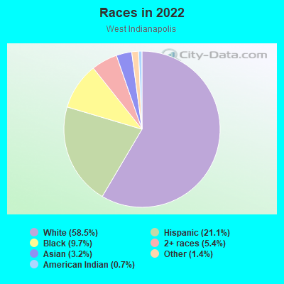
- 11,71658.5%White
- 4,21621.1%Hispanic or Latino
- 1,9399.7%Black
- 1,0875.4%Two or more races
- 6483.2%Asian
- 2771.4%Some other race
- 1410.7%American Indian
Distribution of median household income
![Distribution of median household income]()
- 439Less than $10,000
- 848$10,000 to $19,999
- 1,181$20,000 to $29,999
- 1,594$30,000 to $39,999
- 527$40,000 to $49,999
- 398$50,000 to $59,999
- 948$60,000 to $74,999
- 829$75,000 to $99,999
- 778$100,000 to $124,999
- 586$125,000 to $149,999
- 385$150,000 to $199,999
- 242$200,000 or more

Distribution of owner-occupied house/condo value
![Distribution of owner-occupied house/condo value]()
- 2,167Less than $50,000
- 3,515$50,000 to $99,999
- 711$100,000 to $149,999
- 904$150,000 to $199,999
- 1,117$200,000 to $249,999
- 251$300,000 to $399,999
- 208$400,000 to $499,999
- 432$500,000 to $749,999
- 102$750,000 to $999,999

Distribution of rent paid by renters
![Distribution of rent paid by renters]()
- 394$300 to $399
- 1,183$400 to $499
- 1,439$500 to $599
- 669$600 to $699
- 771$700 to $799
- 396$800 to $899
- 591$900 to $999
- 246$1,000 to $1,249
- 668$1,250 to $1,499
- 74$1,500 to $1,999

Median rent in 2022:
| West Indianapolis: | $702 |
| Indianapolis: | $846 |
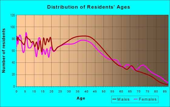
| Males: | 9,205 |
| Females: | 8,487 |
Males:
| This neighborhood: | 35.8 years |
| Whole city: | 32.9 years |
| This neighborhood: | 37.6 years |
| Whole city: | 35.4 years |
Average household size:
| West Indianapolis: | 5.0 people |
| Indianapolis: | 2.3 people |
Percentage of family households:
| West Indianapolis: | 49.3% |
| Indianapolis: | 42.9% |
| Here: | 34.2% |
| Indianapolis: | 37.4% |
Percentage of married-couple families with children (among all households):
| West Indianapolis: | 18.8% |
| Indianapolis: | 26.5% |
Percentage of single-mother households (among all households):
| West Indianapolis: | 17.4% |
| Indianapolis: | 12.9% |
Percentage of never married males 15 years old and over:
Percentage of never married females 15 years old and over:
| West Indianapolis: | 21.1% |
| Indianapolis: | 19.9% |
Percentage of never married females 15 years old and over:
| West Indianapolis: | 15.0% |
| city: | 19.2% |
Percentage of people that speak English not well or not at all:
| West Indianapolis: | 6.3% |
| Indianapolis: | 4.2% |
Percentage of people born in this state:
Percentage of people born in another U.S. state:
Percentage of native residents but born outside the U.S.:
Percentage of foreign born residents:
| Here: | 62.8% |
| Indianapolis: | 63.1% |
Percentage of people born in another U.S. state:
| West Indianapolis: | 18.5% |
| Indianapolis: | 23.6% |
Percentage of native residents but born outside the U.S.:
| Here: | 3.0% |
| city: | 1.1% |
Percentage of foreign born residents:
| Here: | 15.7% |
| Indianapolis: | 12.2% |
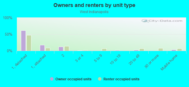
Owner-occupied
Renter-occupied

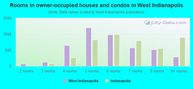
- Rooms in owner-occupied houses and condos in West Indianapolis
- 01 room
- 772 rooms
- 1333 rooms
- 6514 rooms
- 1,2035 rooms
- 9836 rooms
- 5787 rooms
- 5198 rooms
- 2889+ rooms
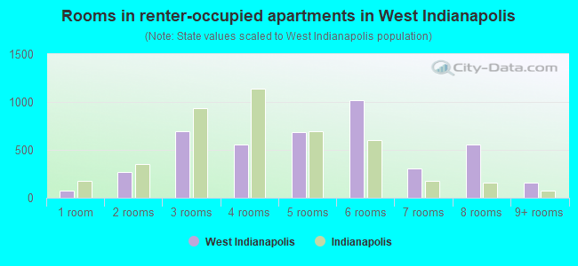
- Rooms in renter-occupied apartments in West Indianapolis
- 711 room
- 2672 rooms
- 6943 rooms
- 5564 rooms
- 6865 rooms
- 1,0146 rooms
- 3037 rooms
- 5538 rooms
- 1549+ rooms
Owner-occupied
Renter-occupied
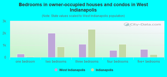
- Bedrooms in owner-occupied houses and condos in West Indianapolis
- 0no bedroom
- 2711 bedroom
- 1,9912 bedrooms
- 1,0783 bedrooms
- 5694 bedrooms
- 6675+ bedrooms
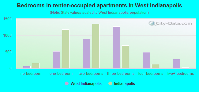
- Bedrooms in renter-occupied apartments in West Indianapolis
- 71no bedroom
- 5221 bedroom
- 8952 bedrooms
- 1,2723 bedrooms
- 4934 bedrooms
- 2865+ bedrooms
Average number of cars or other vehicles available in houses/condos:
Average number of cars or other vehicles available in apartments:
| This neighborhood: | 2.0 |
| Indianapolis: | 2.0 |
Average number of cars or other vehicles available in apartments:
| Here: | 1.5 |
| city: | 1.2 |
Percentage of units with a mortgage:
| West Indianapolis: | 55.2% |
| Indianapolis: | 68.8% |
Average estimated value of detached houses in 2022 (75.7% of all units):
| West Indianapolis: | $110,586 |
| Indiana: | $257,916 |
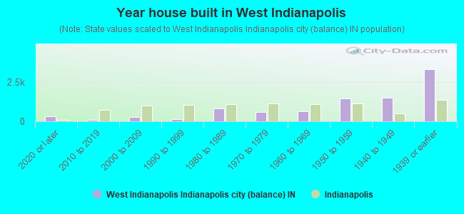
- Year house built in West Indianapolis
- 3392020 or later
- 1122010 to 2019
- 2852000 to 2009
- 1341990 to 1999
- 8321980 to 1989
- 6061970 to 1979
- 6481960 to 1969
- 1,4281950 to 1959
- 1,4761940 to 1949
- 3,2871939 or earlier
City-data.com crime index for city in 2020 (higher means more crime):
| City: | 465.4 |
| U.S. average: | 219.5 |
Travel time to work (commute)
![Travel time to work (commute)]()
- 99Less than 5 minutes
- 2905 to 9 minutes
- 86410 to 14 minutes
- 85415 to 19 minutes
- 84120 to 24 minutes
- 38725 to 29 minutes
- 1,29030 to 34 minutes
- 19735 to 39 minutes
- 14140 to 44 minutes
- 38645 to 59 minutes
- 11760 to 89 minutes
- 11390 or more minutes

Means of transportation to work
![Means of transportation to work]()
- 81.0%7,241Drove a car alone
- 11.9%1,061Carpooled
- 6.3%566Bus
- 4.7%419Taxi
- 9.2%821Motorcycle
- 1.8%162Bicycle
- 8.6%768Walked
- 5.9%524Other means
- 5.4%483Worked at home

Time leaving home to go to work
![Time leaving home to go to work]()
- 30212:00 a.m. to 4:59 a.m.
- 2265:00 a.m. to 5:29 a.m.
- 1935:30 a.m. to 5:59 a.m.
- 7446:00 a.m. to 6:29 a.m.
- 3896:30 a.m. to 6:59 a.m.
- 7367:00 a.m. to 7:29 a.m.
- 8397:30 a.m. to 7:59 a.m.
- 3788:00 a.m. to 8:29 a.m.
- 3508:30 a.m. to 8:59 a.m.
- 2539:00 a.m. to 9:59 a.m.
- 5510:00 a.m. to 10:59 a.m.
- 12911:00 a.m. to 11:59 a.m.
- 34012:00 p.m. to 3:59 p.m.
- 3804:00 p.m. to 11:59 p.m.

Occupations of males:
- Percentage of males in management occupations (except farmers):
Here: 7.5% city: 10.3%
- Percentage of males in business and financial operations occupations:
Here: 2.9% city: 5.4%
- Percentage of males in computer and mathematical occupations:
Here: 3.0% city: 4.6%
- Percentage of males in architecture and engineering occupations:
Here: 2.8% city: 2.6%
- Percentage of males in legal occupations:
Here: 2.8% city: 1.4%
- Percentage of males in arts, design, entertainment, sports, and media occupations:
Here: 1.4% city: 1.9%
- Percentage of males in service occupations:
Here: 15.6% city: 12.5%
- Percentage of males in sales and office occupations:
Here: 11.8% city: 15.6%
- Percentage of males in farming, fishing, and forestry occupations:
Here: 2.6% city: 0.3%
- Percentage of males in construction, extraction, and maintenance occupations:
Here: 19.0% city: 7.9%
- Percentage of males in production occupations:
Here: 10.1% city: 9.0%
- Percentage of males in transportation occupations:
Here: 11.2% city: 6.4%
- Percentage of males in material moving occupations:
Here: 4.0% city: 9.4%
Occupations of females:
- Percentage of females in management occupations (except farmers):
Here: 7.5% city: 8.6%
- Percentage of females in business and financial operations occupations:
Here: 2.2% city: 6.9%
- Percentage of females in education, training, and library occupations:
Here: 4.9% city: 7.5%
- Percentage of females in arts, design, entertainment, sports, and media occupations:
Here: 1.8% city: 2.1%
- Percentage of females in healthcare practitioners and technical occupations:
Here: 1.7% city: 10.8%
- Percentage of females in service occupations:
Here: 30.5% city: 18.5%
- Percentage of females in sales and office occupations:
Here: 27.2% city: 26.4%
- Percentage of females in production occupations:
Here: 9.8% city: 4.5%
- Percentage of females in transportation occupations:
Here: 2.8% city: 1.2%
- Percentage of females in material moving occupations:
Here: 9.6% city: 4.9%
Percentage of people 16-64 in Armed Forces:
| West Indianapolis: | 0.1% |
| Indianapolis: | 0.1% |
Education in this neighborhood (subdivision or community):
- Percentage of people 3 years and older in K-12 schools:
West Indianapolis: 25.1% Indianapolis: 17.3%
- Percentage of people 3 years and older in undergraduate colleges:
West Indianapolis: 7.1% Indianapolis: 4.5%
- Percentage of people 3 years and older in grad. or professional schools:
West Indianapolis: 8.3% Indianapolis: 1.9%
- Percentage of students K-12 enrolled in private schools:
West Indianapolis: 109.6% Indianapolis: 14.8%
Percentage of population below poverty level:
| West Indianapolis: | 24.6% |
| Indianapolis: | 15.9% |
Median year owner moved in (as recorded in 2022):
| West Indianapolis: | 2004 |
| Indianapolis: | 2012 |
Percentage of married-couple families with both working:
| West Indianapolis: | 124.1% |
| Indianapolis: | 72.1% |
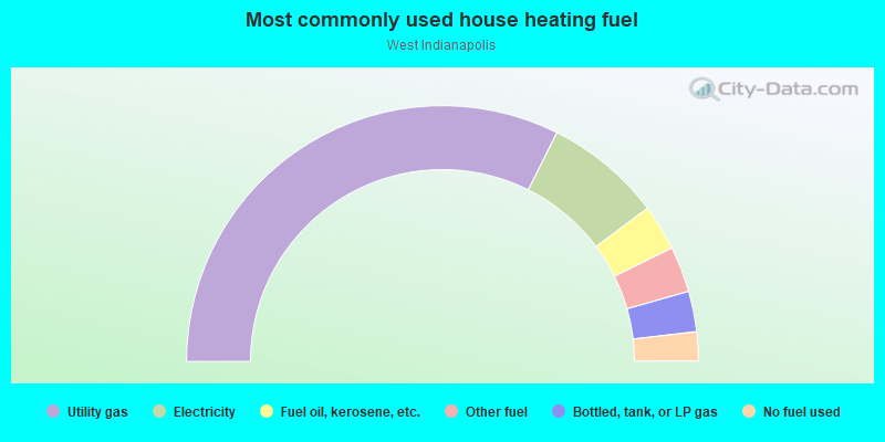
- 64.7%Utility gas
- 14.8%Electricity
- 5.8%Fuel oil, kerosene, etc.
- 5.8%Other fuel
- 5.1%Bottled, tank, or LP gas
- 3.7%No fuel used
Limited-access highways (interstate or state) in this neighborhood:
I- 70
Length: 6.61 miles
Directions: E-W, SW-NE
Directions: E-W, SW-NE
Highways in this neighborhood:
Kentucky Ave (State Rd 67)
Length: 2.10 miles
Directions: N-S, SW-NE
Address range: 900 to 2199
Directions: N-S, SW-NE
Address range: 900 to 2199
US Hwy 40 (W Washington St)
Length: 0.28 miles
Direction: E-W
Address range: 3600 to 3755
Direction: E-W
Address range: 3600 to 3755
Roads and streets:
W Morris St
Length: 3.50 miles
Direction: E-W
Address range: 900 to 3664
Direction: E-W
Address range: 900 to 3664
Oliver Ave
Length: 2.76 miles
Directions: E-W, SW-NE
Address range: 881 to 3699
Directions: E-W, SW-NE
Address range: 881 to 3699
W Raymond St
Length: 2.47 miles
Directions: E-W, SW-NE
Address range: 600 to 3399
Directions: E-W, SW-NE
Address range: 600 to 3399
W Minnesota St
Length: 2.32 miles
Directions: E-W, SE-NW, SW-NE
Address range: 1500 to 3597
Directions: E-W, SE-NW, SW-NE
Address range: 1500 to 3597
W McCarty St
Length: 2.25 miles
Direction: E-W
Address range: 1000 to 3299
Direction: E-W
Address range: 1000 to 3299
S Harding St
Length: 1.84 miles
Directions: N-S, SW-NE
Address range: 186 to 2199
Directions: N-S, SW-NE
Address range: 186 to 2199
S White River Pkwy W Dr
Length: 1.74 miles
Directions: E-W, N-S, SE-NW, SW-NE
Address range: 134 to 2199
Directions: E-W, N-S, SE-NW, SW-NE
Address range: 134 to 2199
W Ray St
Length: 1.67 miles
Directions: E-W, SW-NE
Address range: 800 to 2899
Directions: E-W, SW-NE
Address range: 800 to 2899
S Belmont Ave
Length: 1.66 miles
Direction: N-S
Address range: 457 to 2118
Direction: N-S
Address range: 457 to 2118
S Tibbs Ave
Length: 1.56 miles
Directions: N-S, SE-NW
Address range: 600 to 2199
Directions: N-S, SE-NW
Address range: 600 to 2199
W Miller St
Length: 1.46 miles
Directions: E-W, SE-NW
Address range: 1400 to 3499
Directions: E-W, SE-NW
Address range: 1400 to 3499
Howard St
Length: 1.44 miles
Direction: E-W
Address range: 1400 to 3499
Direction: E-W
Address range: 1400 to 3499
S Pershing Ave
Length: 1.27 miles
Direction: N-S
Address range: 700 to 2099
Direction: N-S
Address range: 700 to 2099
S Reisner St
Length: 1.11 miles
Directions: E-W, N-S, SE-NW, SW-NE
Address range: 600 to 1799
Directions: E-W, N-S, SE-NW, SW-NE
Address range: 600 to 1799
S Warman Ave
Length: 1.10 miles
Direction: N-S
Address range: 192 to 2199
Direction: N-S
Address range: 192 to 2199
W Wilkins St
Length: 0.97 miles
Direction: E-W
Address range: 1600 to 2899
Direction: E-W
Address range: 1600 to 2899
W Lambert St
Length: 0.91 miles
Direction: E-W
Address range: 1701 to 2599
Direction: E-W
Address range: 1701 to 2599
S Sheffield Ave
Length: 0.86 miles
Directions: N-S, SE-NW
Address range: 700 to 1599
Directions: N-S, SE-NW
Address range: 700 to 1599
Kappes St
Length: 0.83 miles
Directions: E-W, N-S
Address range: 600 to 1599
Directions: E-W, N-S
Address range: 600 to 1599
Division St
Length: 0.82 miles
Directions: N-S, SW-NE
Address range: 300 to 1199
Directions: N-S, SW-NE
Address range: 300 to 1199
Blaine Ave
Length: 0.82 miles
Directions: E-W, N-S, SE-NW
Address range: 1000 to 1799
Directions: E-W, N-S, SE-NW
Address range: 1000 to 1799
S Richland St
Length: 0.79 miles
Directions: N-S, SE-NW
Address range: 600 to 1599
Directions: N-S, SE-NW
Address range: 600 to 1599
Drover St
Length: 0.76 miles
Direction: N-S
Address range: 500 to 1599
Direction: N-S
Address range: 500 to 1599
River Ave
Length: 0.73 miles
Directions: N-S, SW-NE
Address range: 600 to 1199
Directions: N-S, SW-NE
Address range: 600 to 1199
Bertha St
Length: 0.71 miles
Direction: E-W
Address range: 2600 to 3399
Direction: E-W
Address range: 2600 to 3399
Hiatt St
Length: 0.68 miles
Direction: N-S
Address range: 600 to 1599
Direction: N-S
Address range: 600 to 1599
Shepard St
Length: 0.67 miles
Direction: N-S
Address range: 600 to 1599
Direction: N-S
Address range: 600 to 1599
Kelley St
Length: 0.67 miles
Direction: E-W
Direction: E-W
W Henry St
Length: 0.65 miles
Direction: E-W
Address range: 1300 to 3699
Direction: E-W
Address range: 1300 to 3699
Lee St
Length: 0.64 miles
Direction: N-S
Address range: 1100 to 1599
Direction: N-S
Address range: 1100 to 1599
S Somerset Ave
Length: 0.62 miles
Directions: E-W, N-S, SE-NW, SW-NE
Address range: 400 to 1199
Directions: E-W, N-S, SE-NW, SW-NE
Address range: 400 to 1199
S Holmes Ave
Length: 0.57 miles
Direction: N-S
Address range: 192 to 1099
Direction: N-S
Address range: 192 to 1099
S Addison St
Length: 0.56 miles
Direction: N-S
Address range: 200 to 1099
Direction: N-S
Address range: 200 to 1099
Lambert St
Length: 0.56 miles
Direction: E-W
Address range: 1500 to 3599
Direction: E-W
Address range: 1500 to 3599
W Wyoming St
Length: 0.50 miles
Direction: E-W
Address range: 1700 to 2899
Direction: E-W
Address range: 1700 to 2899
S Moreland Ave
Length: 0.48 miles
Direction: N-S
Address range: 1200 to 1799
Direction: N-S
Address range: 1200 to 1799
Birch Ave
Length: 0.44 miles
Directions: N-S, SW-NE
Address range: 500 to 899
Directions: N-S, SW-NE
Address range: 500 to 899
Standard Ave
Length: 0.43 miles
Direction: E-W
Address range: 1200 to 2899
Direction: E-W
Address range: 1200 to 2899
York St
Length: 0.43 miles
Direction: SE-NW
Address range: 1001 to 1499
Direction: SE-NW
Address range: 1001 to 1499
Nordyke Ave
Length: 0.42 miles
Directions: E-W, N-S, SW-NE
Address range: 1200 to 1499
Directions: E-W, N-S, SW-NE
Address range: 1200 to 1499
Arbor Ave
Length: 0.40 miles
Direction: N-S
Address range: 400 to 999
Direction: N-S
Address range: 400 to 999
S Tremont St
Length: 0.39 miles
Direction: N-S
Address range: 700 to 1199
Direction: N-S
Address range: 700 to 1199
S Harris Ave
Length: 0.38 miles
Direction: N-S
Address range: 101 to 599
Direction: N-S
Address range: 101 to 599
Morgan St
Length: 0.38 miles
Direction: E-W
Address range: 1700 to 2399
Direction: E-W
Address range: 1700 to 2399
S Centennial St
Length: 0.37 miles
Direction: N-S
Address range: 1200 to 1799
Direction: N-S
Address range: 1200 to 1799
Coffey St
Length: 0.34 miles
Direction: N-S
Address range: 500 to 999
Direction: N-S
Address range: 500 to 999
Westview Dr
Length: 0.33 miles
Direction: E-W
Address range: 1800 to 2099
Direction: E-W
Address range: 1800 to 2099
Ida St
Length: 0.32 miles
Direction: E-W
Address range: 2600 to 2999
Direction: E-W
Address range: 2600 to 2999
Victoria St
Length: 0.32 miles
Direction: E-W
Address range: 2600 to 2999
Direction: E-W
Address range: 2600 to 2999
S Mount St
Length: 0.32 miles
Direction: N-S
Address range: 192 to 1099
Direction: N-S
Address range: 192 to 1099
Delmar Ave
Length: 0.31 miles
Direction: E-W
Address range: 3400 to 3499
Direction: E-W
Address range: 3400 to 3499
Bridge St
Length: 0.30 miles
Direction: N-S
Address range: 1000 to 1499
Direction: N-S
Address range: 1000 to 1499
S Belleview Pl
Length: 0.30 miles
Direction: N-S
Address range: 700 to 1099
Direction: N-S
Address range: 700 to 1099
Conrad Ave
Length: 0.29 miles
Direction: E-W
Address range: 2100 to 2399
Direction: E-W
Address range: 2100 to 2399
Warren Ave
Length: 0.29 miles
Direction: N-S
Address range: 500 to 999
Direction: N-S
Address range: 500 to 999
Marion Ave
Length: 0.29 miles
Direction: N-S
Address range: 500 to 999
Direction: N-S
Address range: 500 to 999
Haines Ave
Length: 0.29 miles
Direction: E-W
Address range: 2001 to 2399
Direction: E-W
Address range: 2001 to 2399
S Alton Ave
Length: 0.28 miles
Directions: N-S, SE-NW
Address range: 1100 to 1499
Directions: N-S, SE-NW
Address range: 1100 to 1499
S Livingston Ave
Length: 0.27 miles
Direction: N-S
Address range: 400 to 599
Direction: N-S
Address range: 400 to 599
Silver Ave
Length: 0.27 miles
Direction: SW-NE
Address range: 1230 to 1499
Direction: SW-NE
Address range: 1230 to 1499
Holly Ave
Length: 0.26 miles
Directions: N-S, SW-NE
Address range: 500 to 699
Directions: N-S, SW-NE
Address range: 500 to 699
Hancock St (Hancock Ave)
Length: 0.26 miles
Direction: N-S
Address range: 194 to 899
Direction: N-S
Address range: 194 to 899
S Berwick Ave
Length: 0.25 miles
Direction: N-S
Address range: 1100 to 1499
Direction: N-S
Address range: 1100 to 1499
Barrett Ave
Length: 0.25 miles
Direction: E-W
Address range: 2100 to 2399
Direction: E-W
Address range: 2100 to 2399
Bedford St
Length: 0.25 miles
Direction: N-S
Address range: 1200 to 1399
Direction: N-S
Address range: 1200 to 1399
S Luett Ave
Length: 0.25 miles
Direction: N-S
Address range: 400 to 599
Direction: N-S
Address range: 400 to 599
S Goodlet Ave
Length: 0.24 miles
Direction: N-S
Address range: 1500 to 1799
Direction: N-S
Address range: 1500 to 1799
Chase St
Length: 0.21 miles
Direction: N-S
Address range: 500 to 999
Direction: N-S
Address range: 500 to 999
W Old Raymond St
Length: 0.21 miles
Direction: E-W
Address range: 2020 to 2099
Direction: E-W
Address range: 2020 to 2099
Thornberry St
Length: 0.20 miles
Directions: E-W, SW-NE
Address range: 2100 to 2299
Directions: E-W, SW-NE
Address range: 2100 to 2299
Morton Ave
Length: 0.19 miles
Direction: E-W
Address range: 2100 to 2399
Direction: E-W
Address range: 2100 to 2399
Martha St
Length: 0.19 miles
Direction: E-W
Address range: 2100 to 2299
Direction: E-W
Address range: 2100 to 2299
S White River Parkway West Dr
Length: 0.17 miles
Direction: N-S
Address range: 600 to 999
Direction: N-S
Address range: 600 to 999
Corrill St
Length: 0.17 miles
Direction: N-S
Address range: 200 to 899
Direction: N-S
Address range: 200 to 899
Wisconsin St
Length: 0.16 miles
Direction: E-W
Address range: 3500 to 3599
Direction: E-W
Address range: 3500 to 3599
Kansas St
Length: 0.16 miles
Direction: E-W
Address range: 3400 to 3499
Direction: E-W
Address range: 3400 to 3499
S Concord St
Length: 0.13 miles
Direction: N-S
Address range: 1500 to 1699
Direction: N-S
Address range: 1500 to 1699
W Alley 575 S
Length: 0.13 miles
Direction: E-W
Direction: E-W
S Rochester Ave
Length: 0.11 miles
Direction: N-S
Address range: 600 to 799
Direction: N-S
Address range: 600 to 799
Gillette St
Length: 0.11 miles
Direction: E-W
Address range: 1300 to 1399
Direction: E-W
Address range: 1300 to 1399
W Alley 1225 S
Length: 0.09 miles
Direction: E-W
Direction: E-W
S Belt St
Length: 0.08 miles
Direction: SE-NW
Address range: 1370 to 1499
Direction: SE-NW
Address range: 1370 to 1499
S Alley 1325 W
Length: 0.08 miles
Direction: N-S
Direction: N-S
Sadie St
Length: 0.08 miles
Direction: N-S
Address range: 800 to 899
Direction: N-S
Address range: 800 to 899
Bolivar Ave
Length: 0.08 miles
Direction: N-S
Address range: 1200 to 1299
Direction: N-S
Address range: 1200 to 1299
Wyoming St
Length: 0.07 miles
Direction: E-W
Direction: E-W
W Kelly St
Length: 0.07 miles
Direction: E-W
Address range: 3536 to 3599
Direction: E-W
Address range: 3536 to 3599
Stock St
Length: 0.07 miles
Directions: E-W, SE-NW
Address range: 1350 to 1499
Directions: E-W, SE-NW
Address range: 1350 to 1499
Fay St
Length: 0.07 miles
Direction: E-W
Address range: 1500 to 1599
Direction: E-W
Address range: 1500 to 1599
Tremont St
Length: 0.07 miles
Direction: N-S
Address range: 1200 to 1299
Direction: N-S
Address range: 1200 to 1299
Vandalia Ave
Length: 0.06 miles
Direction: E-W
Address range: 2800 to 2899
Direction: E-W
Address range: 2800 to 2899
Minnesota Way
Length: 0.06 miles
Directions: E-W, SE-NW
Directions: E-W, SE-NW
Tip St
Length: 0.05 miles
Direction: N-S
Address range: 800 to 899
Direction: N-S
Address range: 800 to 899
W Alley 435 S
Length: 0.04 miles
Direction: E-W
Direction: E-W
S Alley 1550 W
Length: 0.03 miles
Direction: N-S
Direction: N-S
Railroad features:
Csx RR & Norfolk Southern Rlwy (Penn Central RR)
Length: 12.90 miles
Directions: E-W, N-S, SE-NW, SW-NE
Directions: E-W, N-S, SE-NW, SW-NE
Penn Central RR (Csx RR)
Length: 2.04 miles
Directions: E-W, N-S, SE-NW, SW-NE
Directions: E-W, N-S, SE-NW, SW-NE
Baltimore and Ohio RR
Length: 1.39 miles
Directions: E-W, SW-NE
Directions: E-W, SW-NE
Csx RR & Norfolk Southern Rlwy
Length: 0.54 miles
Directions: E-W, N-S
Directions: E-W, N-S
Norfolk and Western Rlwy
Length: 0.03 miles
Direction: E-W
Direction: E-W
Other features:
Big Eagle Crk
Length: 2.66 miles
Directions: E-W, N-S, SE-NW, SW-NE
Directions: E-W, N-S, SE-NW, SW-NE