The East Side (Wadsworth E.) neighborhood in Wadsworth, Ohio (OH), 44230, 44281 detailed profile
Settings
X


Business Search - 14 Million verified businesses
Area: 8.712 square miles
Population: 13,683
Population density:
| The East Side (Wadsworth E.): | 1,571 people per square mile |
| Wadsworth: | 2,534 people per square mile |

- 12,93490.1%White
- 5894.1%Black
- 3882.7%Asian
- 3042.1%Hispanic or Latino
- 1391.0%Two or more races
- 60.04%American Indian

Median household income in 2022:
| The East Side (Wadsworth E.): | $82,677 |
| Wadsworth: | $72,325 |
Distribution of median household income
![Distribution of median household income]()
- 127Less than $10,000
- 1,505$10,000 to $19,999
- 1,712$20,000 to $29,999
- 1,080$30,000 to $39,999
- 643$40,000 to $49,999
- 504$50,000 to $59,999
- 515$60,000 to $74,999
- 1,069$75,000 to $99,999
- 654$100,000 to $124,999
- 322$125,000 to $149,999
- 501$150,000 to $199,999
- 580$200,000 or more

Distribution of owner-occupied house/condo value
![Distribution of owner-occupied house/condo value]()
- 400Less than $50,000
- 2,396$50,000 to $99,999
- 886$100,000 to $149,999
- 1,196$150,000 to $199,999
- 995$200,000 to $249,999
- 976$250,000 to $299,999
- 551$300,000 to $399,999
- 264$400,000 to $499,999
- 129$500,000 to $749,999
- 60$750,000 to $999,999
- 45$1,000,000 or more

Distribution of rent paid by renters
![Distribution of rent paid by renters]()
- 883$200 to $299
- 150$300 to $399
- 1,241$400 to $499
- 879$500 to $599
- 4,315$600 to $699
- 1,582$700 to $799
- 296$800 to $899
- 148$900 to $999
- 351$1,000 to $1,249
- 181$1,250 to $1,499
- 276$1,500 to $1,999
- 852$2,000 or more

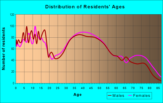
| Males: | 6,600 |
| Females: | 7,083 |
Males:
| This neighborhood: | 40.9 years |
| Whole city: | 37.0 years |
| This neighborhood: | 44.5 years |
| Whole city: | 40.4 years |
Average household size:
| The East Side (Wadsworth E.): | 4.2 people |
| Wadsworth: | 2.4 people |
Percentage of family households:
| The East Side (Wadsworth E.): | 49.7% |
| Wadsworth: | 45.6% |
| Here: | 54.2% |
| Wadsworth: | 49.2% |
Percentage of married-couple families with children (among all households):
| The East Side (Wadsworth E.): | 27.3% |
| Wadsworth: | 30.7% |
Percentage of single-mother households (among all households):
| The East Side (Wadsworth E.): | 8.6% |
| Wadsworth: | 8.5% |
Percentage of never married males 15 years old and over:
Percentage of never married females 15 years old and over:
| The East Side (Wadsworth E.): | 15.1% |
| Wadsworth: | 15.5% |
Percentage of never married females 15 years old and over:
| The East Side (Wadsworth E.): | 16.4% |
| city: | 16.2% |
Percentage of people that speak English not well or not at all:
| The East Side (Wadsworth E.): | 0.0% |
| Wadsworth: | 0.1% |
Percentage of people born in this state:
Percentage of people born in another U.S. state:
Percentage of native residents but born outside the U.S.:
Percentage of foreign born residents:
| Here: | 82.1% |
| Wadsworth: | 81.5% |
Percentage of people born in another U.S. state:
| The East Side (Wadsworth E.): | 15.5% |
| Wadsworth: | 16.2% |
Percentage of native residents but born outside the U.S.:
| Here: | 0.2% |
| city: | 0.3% |
Percentage of foreign born residents:
| Here: | 2.2% |
| Wadsworth: | 2.0% |

Owner-occupied
Renter-occupied


- Rooms in owner-occupied houses and condos in The East Side <
> - 761 room
- 02 rooms
- 3623 rooms
- 3314 rooms
- 5095 rooms
- 9406 rooms
- 8327 rooms
- 5418 rooms
- 1,1649+ rooms

- Rooms in renter-occupied apartments in The East Side <
> - 2681 room
- 2942 rooms
- 7193 rooms
- 9984 rooms
- 2265 rooms
- 1436 rooms
- 2277 rooms
- 2088 rooms
- 8519+ rooms
Owner-occupied
Renter-occupied

- Bedrooms in owner-occupied houses and condos in The East Side <
> - 76no bedroom
- 121 bedroom
- 5512 bedrooms
- 1,8673 bedrooms
- 1,6524 bedrooms
- 3195+ bedrooms

- Bedrooms in renter-occupied apartments in The East Side <
> - 356no bedroom
- 6901 bedroom
- 1,3382 bedrooms
- 1923 bedrooms
- 8164 bedrooms
- 55+ bedrooms
Average number of cars or other vehicles available in houses/condos:
Average number of cars or other vehicles available in apartments:
| This neighborhood: | 1.7 |
| Wadsworth: | 2.2 |
Average number of cars or other vehicles available in apartments:
| Here: | |
| city: |
Percentage of units with a mortgage:
| The East Side (Wadsworth E.): | 69.2% |
| Wadsworth: | 69.0% |
Average estimated value of detached houses in 2022 (78.4% of all units):
| The East Side (Wadsworth E.): | $209,211 |
| Ohio: | $254,366 |

- Year house built in The East Side <
> - 02020 or later
- 5062010 to 2019
- 9662000 to 2009
- 5861990 to 1999
- 4541980 to 1989
- 9371970 to 1979
- 4591960 to 1969
- 8251950 to 1959
- 2271940 to 1949
- 1,2371939 or earlier

City-data.com crime index for city in 2020 (higher means more crime):
| City: | 90.1 |
| U.S. average: | 219.5 |
Travel time to work (commute)
![Travel time to work (commute)]()
- 219Less than 5 minutes
- 7505 to 9 minutes
- 78410 to 14 minutes
- 88415 to 19 minutes
- 1,07620 to 24 minutes
- 54125 to 29 minutes
- 77230 to 34 minutes
- 40535 to 39 minutes
- 23140 to 44 minutes
- 26445 to 59 minutes
- 22760 to 89 minutes
- 7490 or more minutes

Means of transportation to work
![Means of transportation to work]()
- 82.8%5,978Drove a car alone
- 4.3%308Carpooled
- 0.9%65Bus
- 0.4%30Motorcycle
- 0.7%50Bicycle
- 9.4%682Walked
- 1.9%138Other means
- 11.8%853Worked at home

Time leaving home to go to work
![Time leaving home to go to work]()
- 47312:00 a.m. to 4:59 a.m.
- 705:00 a.m. to 5:29 a.m.
- 1945:30 a.m. to 5:59 a.m.
- 5526:00 a.m. to 6:29 a.m.
- 6996:30 a.m. to 6:59 a.m.
- 7947:00 a.m. to 7:29 a.m.
- 6497:30 a.m. to 7:59 a.m.
- 6328:00 a.m. to 8:29 a.m.
- 4408:30 a.m. to 8:59 a.m.
- 2439:00 a.m. to 9:59 a.m.
- 10910:00 a.m. to 10:59 a.m.
- 9411:00 a.m. to 11:59 a.m.
- 57012:00 p.m. to 3:59 p.m.
- 6564:00 p.m. to 11:59 p.m.

Occupations of males:
- Percentage of males in management occupations (except farmers):
Here: 12.3% city: 13.1%
- Percentage of males in business and financial operations occupations:
Here: 4.5% city: 3.8%
- Percentage of males in computer and mathematical occupations:
Here: 5.7% city: 4.9%
- Percentage of males in architecture and engineering occupations:
Here: 5.8% city: 6.8%
- Percentage of males in life, physical, and social science occupations:
Here: 1.8% city: 2.3%
- Percentage of males in education, training, and library occupations:
Here: 2.6% city: 3.5%
- Percentage of males in arts, design, entertainment, sports, and media occupations:
Here: 1.2% city: 1.5%
- Percentage of males in healthcare practitioners and technical occupations:
Here: 5.6% city: 4.1%
- Percentage of males in service occupations:
Here: 10.7% city: 12.3%
- Percentage of males in sales and office occupations:
Here: 15.1% city: 17.2%
- Percentage of males in construction, extraction, and maintenance occupations:
Here: 6.4% city: 6.0%
- Percentage of males in production occupations:
Here: 7.6% city: 6.6%
- Percentage of males in transportation occupations:
Here: 4.8% city: 3.5%
- Percentage of males in material moving occupations:
Here: 6.4% city: 6.1%
Occupations of females:
- Percentage of females in management occupations (except farmers):
Here: 13.6% city: 9.7%
- Percentage of females in business and financial operations occupations:
Here: 5.6% city: 4.0%
- Percentage of females in computer and mathematical occupations:
Here: 3.6% city: 2.6%
- Percentage of females in community and social services occupations:
Here: 3.1% city: 2.4%
- Percentage of females in education, training, and library occupations:
Here: 12.2% city: 16.0%
- Percentage of females in arts, design, entertainment, sports, and media occupations:
Here: 2.9% city: 2.2%
- Percentage of females in healthcare practitioners and technical occupations:
Here: 9.9% city: 14.2%
- Percentage of females in service occupations:
Here: 16.7% city: 14.8%
- Percentage of females in sales and office occupations:
Here: 20.5% city: 22.7%
- Percentage of females in production occupations:
Here: 2.1% city: 2.5%
- Percentage of females in transportation occupations:
Here: 2.7% city: 1.7%
- Percentage of females in material moving occupations:
Here: 3.6% city: 4.0%
Percentage of people 16-64 in Armed Forces:
| The East Side (Wadsworth E.): | 0.0% |
| Wadsworth: | 0.0% |
Education in this neighborhood (subdivision or community):
- Percentage of people 3 years and older in K-12 schools:
The East Side (Wadsworth E.): 21.2% Wadsworth: 16.3%
- Percentage of people 3 years and older in undergraduate colleges:
The East Side (Wadsworth E.): 5.0% Wadsworth: 4.2%
- Percentage of people 3 years and older in grad. or professional schools:
The East Side (Wadsworth E.): 3.3% Wadsworth: 1.6%
- Percentage of students K-12 enrolled in private schools:
The East Side (Wadsworth E.): 70.1% Wadsworth: 7.4%
Percentage of population below poverty level:
| The East Side (Wadsworth E.): | 7.3% |
| Wadsworth: | 8.7% |
Median year owner moved in (as recorded in 2022):
| The East Side (Wadsworth E.): | 2009 |
| Wadsworth: | 2009 |
Percentage of married-couple families with both working:
| The East Side (Wadsworth E.): | 74.1% |
| Wadsworth: | 77.8% |

- 69.9%Utility gas
- 13.7%Electricity
- 5.7%Other fuel
- 4.9%No fuel used
- 2.3%Bottled, tank, or LP gas
- 1.8%Fuel oil, kerosene, etc.
- 1.7%Wood
Limited-access highways (interstate or state) in this neighborhood:
US Hwy 224 (I- 76)
Length: 2.81 miles
Directions: E-W, SE-NW
Directions: E-W, SE-NW
Highways in this neighborhood:
State Rte 261 (Akron Rd)
Length: 3.01 miles
Direction: E-W
Address range: 134 to 899
Direction: E-W
Address range: 134 to 899
State Rte 94 (High St)
Length: 0.13 miles
Direction: N-S
Address range: 350 to 414
Direction: N-S
Address range: 350 to 414
Roads and streets:
Johnson Rd
Length: 3.33 miles
Directions: E-W, SE-NW, SW-NE
Address range: 1 to 998
Directions: E-W, SE-NW, SW-NE
Address range: 1 to 998
Wall Rd (Twp Rd 145)
Length: 2.84 miles
Directions: E-W, N-S, SE-NW
Address range: 1 to 1049
Directions: E-W, N-S, SE-NW
Address range: 1 to 1049
Broad St (Greenwich Rd)
Length: 2.62 miles
Direction: E-W
Address range: 150 to 1084
Direction: E-W
Address range: 150 to 1084
Co Hwy 59 (Silvercreek Rd)
Length: 2.55 miles
Direction: N-S
Address range: 100 to 10499
Direction: N-S
Address range: 100 to 10499
Eastern Rd (Co Hwy 150, Twp Rd 150)
Length: 2.22 miles
Direction: E-W
Address range: 2 to 1092
Direction: E-W
Address range: 2 to 1092
Length: 1.72 miles
Directions: E-W, N-S, SE-NW
Address range: 1 to 8975
Directions: E-W, N-S, SE-NW
Address range: 1 to 8975
Highland Ave
Length: 1.41 miles
Directions: E-W, N-S, SE-NW
Address range: 101 to 835
Directions: E-W, N-S, SE-NW
Address range: 101 to 835
Farr Ave
Length: 1.19 miles
Direction: E-W
Address range: 100 to 699
Direction: E-W
Address range: 100 to 699
Twp Rd 192 (Durling Dr)
Length: 1.14 miles
Directions: N-S, SE-NW
Address range: 121 to 512
Directions: N-S, SE-NW
Address range: 121 to 512
Crestwood Ave
Length: 1.12 miles
Directions: E-W, N-S, SE-NW, SW-NE
Address range: 252 to 834
Directions: E-W, N-S, SE-NW, SW-NE
Address range: 252 to 834
Woodland Ave
Length: 1.11 miles
Directions: N-S, SE-NW
Address range: 253 to 835
Directions: N-S, SE-NW
Address range: 253 to 835
E Bergey St
Length: 0.96 miles
Directions: E-W, N-S, SE-NW, SW-NE
Address range: 180 to 599
Directions: E-W, N-S, SE-NW, SW-NE
Address range: 180 to 599
Silvercrest Rd (Twp Rd 143)
Length: 0.93 miles
Directions: E-W, SE-NW
Address range: 400 to 692
Directions: E-W, SE-NW
Address range: 400 to 692
Summit St
Length: 0.92 miles
Directions: N-S, SE-NW
Address range: 100 to 519
Directions: N-S, SE-NW
Address range: 100 to 519
Red Rock Dr
Length: 0.89 miles
Directions: E-W, N-S, SE-NW, SW-NE
Address range: 300 to 739
Directions: E-W, N-S, SE-NW, SW-NE
Address range: 300 to 739
Longbrook Dr
Length: 0.86 miles
Directions: E-W, SE-NW, SW-NE
Directions: E-W, SE-NW, SW-NE
Williams Reserve Blvd
Length: 0.85 miles
Directions: E-W, N-S, SE-NW
Directions: E-W, N-S, SE-NW
Briarthorn Crescent Dr
Length: 0.82 miles
Directions: E-W, N-S, SE-NW, SW-NE
Directions: E-W, N-S, SE-NW, SW-NE
N Lyman St
Length: 0.74 miles
Direction: N-S
Address range: 100 to 468
Direction: N-S
Address range: 100 to 468
Meadowcreek Dr
Length: 0.73 miles
Directions: E-W, N-S, SE-NW, SW-NE
Directions: E-W, N-S, SE-NW, SW-NE
S Medina Line Rd (Co Hwy 2, County Line Rd)
Length: 0.70 miles
Direction: N-S
Address range: 3406 to 3829
Direction: N-S
Address range: 3406 to 3829
Brook Rd
Length: 0.68 miles
Direction: E-W
Address range: 843 to 999
Direction: E-W
Address range: 843 to 999
3rd St
Length: 0.66 miles
Direction: N-S
Address range: 100 to 410
Direction: N-S
Address range: 100 to 410
Water St
Length: 0.64 miles
Directions: E-W, N-S
Address range: 156 to 399
Directions: E-W, N-S
Address range: 156 to 399
High Point Dr
Length: 0.63 miles
Direction: N-S
Address range: 100 to 449
Direction: N-S
Address range: 100 to 449
Twp Rd 235 (Wilson Rd)
Length: 0.63 miles
Direction: N-S
Address range: 1 to 349
Direction: N-S
Address range: 1 to 349
East St
Length: 0.62 miles
Direction: N-S
Address range: 100 to 443
Direction: N-S
Address range: 100 to 443
Archwood Rd
Length: 0.61 miles
Directions: E-W, N-S, SE-NW, SW-NE
Address range: 800 to 909
Directions: E-W, N-S, SE-NW, SW-NE
Address range: 800 to 909
Kings Cross Dr
Length: 0.60 miles
Directions: E-W, N-S, SE-NW
Address range: 800 to 923
Directions: E-W, N-S, SE-NW
Address range: 800 to 923
Oak St
Length: 0.60 miles
Direction: E-W
Address range: 316 to 599
Direction: E-W
Address range: 316 to 599
Chestnut St
Length: 0.59 miles
Direction: E-W
Address range: 163 to 377
Direction: E-W
Address range: 163 to 377
1st St
Length: 0.59 miles
Directions: N-S, SE-NW
Address range: 112 to 399
Directions: N-S, SE-NW
Address range: 112 to 399
Woodcrest Dr
Length: 0.58 miles
Directions: E-W, N-S, SE-NW, SW-NE
Address range: 412 to 799
Directions: E-W, N-S, SE-NW, SW-NE
Address range: 412 to 799
Sparrow Way
Length: 0.58 miles
Direction: N-S
Address range: 600 to 799
Direction: N-S
Address range: 600 to 799
Queens Gate Way
Length: 0.56 miles
Directions: N-S, SW-NE
Directions: N-S, SW-NE
Madison Trl (Twp Hwy 791)
Length: 0.54 miles
Directions: E-W, SW-NE
Directions: E-W, SW-NE
Twp Hwy 213 (Homestead Dr, Homestead Rd)
Length: 0.53 miles
Direction: N-S
Address range: 9800 to 10099
Direction: N-S
Address range: 9800 to 10099
Dohner Dr
Length: 0.53 miles
Directions: E-W, N-S, SE-NW, SW-NE
Address range: 306 to 599
Directions: E-W, N-S, SE-NW, SW-NE
Address range: 306 to 599
Twp Hwy 190 (Rischel Rd)
Length: 0.52 miles
Directions: N-S, SW-NE
Address range: 10200 to 10499
Directions: N-S, SW-NE
Address range: 10200 to 10499
S Medina Line Rd (Medina Line Rd)
Length: 0.50 miles
Direction: N-S
Address range: 5008 to 5337
Direction: N-S
Address range: 5008 to 5337
South Blvd
Length: 0.49 miles
Directions: E-W, SE-NW
Address range: 414 to 468
Directions: E-W, SE-NW
Address range: 414 to 468
Oakcrest Dr
Length: 0.47 miles
Directions: E-W, N-S, SW-NE
Address range: 544 to 799
Directions: E-W, N-S, SW-NE
Address range: 544 to 799
S Lyman St
Length: 0.47 miles
Direction: N-S
Address range: 100 to 343
Direction: N-S
Address range: 100 to 343
Hillcrest Dr
Length: 0.45 miles
Directions: E-W, SE-NW
Address range: 600 to 809
Directions: E-W, SE-NW
Address range: 600 to 809
Red Rose Dr
Length: 0.44 miles
Directions: E-W, N-S, SE-NW
Directions: E-W, N-S, SE-NW
Baird Ave
Length: 0.44 miles
Direction: N-S
Address range: 114 to 330
Direction: N-S
Address range: 114 to 330
Thicket Trl (Twp Hwy 790)
Length: 0.43 miles
Directions: N-S, SW-NE
Directions: N-S, SW-NE
E Walnut St
Length: 0.43 miles
Direction: E-W
Address range: 179 to 343
Direction: E-W
Address range: 179 to 343
E Boyer St
Length: 0.42 miles
Direction: E-W
Address range: 122 to 278
Direction: E-W
Address range: 122 to 278
Fairview Ave
Length: 0.41 miles
Directions: E-W, N-S, SW-NE
Address range: 36 to 246
Directions: E-W, N-S, SW-NE
Address range: 36 to 246
Twp Rd 238 (Mills Rd)
Length: 0.41 miles
Direction: E-W
Address range: 844 to 999
Direction: E-W
Address range: 844 to 999
Pheasant Run
Length: 0.41 miles
Directions: E-W, N-S, SW-NE
Address range: 200 to 499
Directions: E-W, N-S, SW-NE
Address range: 200 to 499
Mc Entee Dr
Length: 0.40 miles
Directions: E-W, N-S, SE-NW, SW-NE
Address range: 432 to 586
Directions: E-W, N-S, SE-NW, SW-NE
Address range: 432 to 586
Twp Rd 385 (Eastview Ave)
Length: 0.40 miles
Directions: E-W, N-S, SW-NE
Address range: 663 to 875
Directions: E-W, N-S, SW-NE
Address range: 663 to 875
E Good Ave
Length: 0.40 miles
Directions: E-W, N-S, SE-NW, SW-NE
Address range: 116 to 270
Directions: E-W, N-S, SE-NW, SW-NE
Address range: 116 to 270
Twp Hwy 248 (Weaverville Rd)
Length: 0.39 miles
Directions: E-W, N-S
Address range: 113 to 142
Directions: E-W, N-S
Address range: 113 to 142
Tanglewood Trl
Length: 0.39 miles
Directions: E-W, N-S, SE-NW
Address range: 165 to 339
Directions: E-W, N-S, SE-NW
Address range: 165 to 339
E Prospect St
Length: 0.39 miles
Direction: E-W
Address range: 131 to 179
Direction: E-W
Address range: 131 to 179
Twp Hwy 752 (Silver Fox Dr)
Length: 0.38 miles
Direction: E-W
Direction: E-W
Park St
Length: 0.38 miles
Direction: E-W
Address range: 112 to 249
Direction: E-W
Address range: 112 to 249
Olympic Way
Length: 0.38 miles
Directions: N-S, SW-NE
Address range: 600 to 610
Directions: N-S, SW-NE
Address range: 600 to 610
Allen Dr
Length: 0.37 miles
Directions: N-S, SE-NW
Address range: 363 to 530
Directions: N-S, SE-NW
Address range: 363 to 530
Wintergreen Dr
Length: 0.34 miles
Directions: N-S, SE-NW
Address range: 370 to 559
Directions: N-S, SE-NW
Address range: 370 to 559
Brouse Dr
Length: 0.34 miles
Direction: E-W
Address range: 144 to 252
Direction: E-W
Address range: 144 to 252
Twp Rd 288 (Beech Dr)
Length: 0.34 miles
Directions: E-W, N-S, SE-NW
Address range: 9943 to 10044
Directions: E-W, N-S, SE-NW
Address range: 9943 to 10044
Meadow Dr
Length: 0.34 miles
Direction: N-S
Address range: 418 to 555
Direction: N-S
Address range: 418 to 555
Twp Hwy 699 (Chardoney Dr)
Length: 0.33 miles
Directions: E-W, N-S, SW-NE
Directions: E-W, N-S, SW-NE
Southbay Dr
Length: 0.33 miles
Directions: E-W, SE-NW
Directions: E-W, SE-NW
Bent Creek Dr
Length: 0.31 miles
Directions: E-W, N-S, SE-NW, SW-NE
Address range: 600 to 799
Directions: E-W, N-S, SE-NW, SW-NE
Address range: 600 to 799
Ohio Ave
Length: 0.31 miles
Directions: E-W, N-S, SE-NW
Address range: 117 to 243
Directions: E-W, N-S, SE-NW
Address range: 117 to 243
Twp Hwy 344 (Ruth Dr)
Length: 0.31 miles
Directions: N-S, SW-NE
Address range: 10066 to 10182
Directions: N-S, SW-NE
Address range: 10066 to 10182
Tamarac Trl
Length: 0.31 miles
Directions: E-W, N-S, SE-NW, SW-NE
Address range: 600 to 749
Directions: E-W, N-S, SE-NW, SW-NE
Address range: 600 to 749
Royal Woods Dr
Length: 0.31 miles
Directions: E-W, SW-NE
Address range: 538 to 655
Directions: E-W, SW-NE
Address range: 538 to 655
Twp Rd 386 (Beechwood Dr)
Length: 0.30 miles
Direction: E-W
Address range: 142 to 248
Direction: E-W
Address range: 142 to 248
Springdale Ave
Length: 0.29 miles
Direction: E-W
Address range: 400 to 514
Direction: E-W
Address range: 400 to 514
Bear Run (Twp Hwy 753)
Length: 0.29 miles
Direction: N-S
Direction: N-S
Silvermeadow Dr
Length: 0.29 miles
Direction: N-S
Direction: N-S
Fairlawn Ave
Length: 0.28 miles
Direction: N-S
Address range: 101 to 216
Direction: N-S
Address range: 101 to 216
Southpark Dr
Length: 0.28 miles
Directions: E-W, N-S, SE-NW
Address range: 137 to 299
Directions: E-W, N-S, SE-NW
Address range: 137 to 299
Arcadia Rd
Length: 0.28 miles
Direction: E-W
Direction: E-W
Twp Hwy 289 (Dale Dr)
Length: 0.28 miles
Directions: N-S, SW-NE
Address range: 10000 to 10199
Directions: N-S, SW-NE
Address range: 10000 to 10199
Falk Ave
Length: 0.28 miles
Direction: E-W
Address range: 248 to 270
Direction: E-W
Address range: 248 to 270
Takacs Dr
Length: 0.27 miles
Directions: E-W, N-S, SE-NW
Address range: 160 to 199
Directions: E-W, N-S, SE-NW
Address range: 160 to 199
Hillside Dr
Length: 0.26 miles
Direction: E-W
Address range: 100 to 299
Direction: E-W
Address range: 100 to 299
Ashbrook Dr
Length: 0.26 miles
Direction: E-W
Address range: 51 to 799
Direction: E-W
Address range: 51 to 799
School Dr
Length: 0.26 miles
Direction: E-W
Address range: 500 to 599
Direction: E-W
Address range: 500 to 599
Northpark Dr
Length: 0.26 miles
Directions: E-W, N-S, SW-NE
Address range: 145 to 299
Directions: E-W, N-S, SW-NE
Address range: 145 to 299
Twp Hwy 698 (Questa Ct)
Length: 0.25 miles
Directions: E-W, N-S, SE-NW, SW-NE
Directions: E-W, N-S, SE-NW, SW-NE
Whitestone Cir
Length: 0.25 miles
Directions: E-W, SW-NE
Address range: 431 to 518
Directions: E-W, SW-NE
Address range: 431 to 518
2nd St
Length: 0.25 miles
Direction: N-S
Address range: 100 to 199
Direction: N-S
Address range: 100 to 199
Leeds Gate
Length: 0.24 miles
Directions: E-W, N-S, SW-NE
Address range: 500 to 599
Directions: E-W, N-S, SW-NE
Address range: 500 to 599
Twp Hwy 791
Length: 0.24 miles
Directions: E-W, SW-NE
Directions: E-W, SW-NE
Twp Hwy 699
Length: 0.24 miles
Directions: E-W, SE-NW
Directions: E-W, SE-NW
Windfall Ln
Length: 0.23 miles
Directions: E-W, N-S, SE-NW, SW-NE
Address range: 258 to 336
Directions: E-W, N-S, SE-NW, SW-NE
Address range: 258 to 336
Woodlawn Ave
Length: 0.23 miles
Directions: E-W, SW-NE
Address range: 428 to 499
Directions: E-W, SW-NE
Address range: 428 to 499
Brookwood Rd
Length: 0.22 miles
Direction: N-S
Address range: 218 to 323
Direction: N-S
Address range: 218 to 323
Duane Ln
Length: 0.22 miles
Direction: E-W
Direction: E-W
Twp Hwy 287 (Fay Dr)
Length: 0.22 miles
Direction: N-S
Address range: 9940 to 10047
Direction: N-S
Address range: 9940 to 10047
Bird St
Length: 0.21 miles
Direction: N-S
Address range: 433 to 614
Direction: N-S
Address range: 433 to 614
Shannon Dr
Length: 0.21 miles
Directions: E-W, N-S, SE-NW, SW-NE
Address range: 300 to 499
Directions: E-W, N-S, SE-NW, SW-NE
Address range: 300 to 499
Elm St
Length: 0.21 miles
Direction: E-W
Address range: 314 to 371
Direction: E-W
Address range: 314 to 371
Portage St
Length: 0.21 miles
Direction: E-W
Address range: 315 to 372
Direction: E-W
Address range: 315 to 372
Twp Hwy 660 (Nelson Ct)
Length: 0.21 miles
Directions: N-S, SW-NE
Directions: N-S, SW-NE
Gordon Ave
Length: 0.21 miles
Direction: N-S
Address range: 101 to 204
Direction: N-S
Address range: 101 to 204
Overlook Ave
Length: 0.21 miles
Direction: N-S
Address range: 100 to 207
Direction: N-S
Address range: 100 to 207
Fernwood Ave
Length: 0.21 miles
Direction: E-W
Address range: 400 to 469
Direction: E-W
Address range: 400 to 469
Ardmore Ave
Length: 0.21 miles
Direction: E-W
Direction: E-W
Twp Hwy 262 (Peggy Dr)
Length: 0.21 miles
Directions: E-W, SW-NE
Address range: 1000 to 1099
Directions: E-W, SW-NE
Address range: 1000 to 1099
Grant Allen Way
Length: 0.20 miles
Direction: N-S
Direction: N-S
Twp Rd 286 (Maple Dr)
Length: 0.20 miles
Directions: E-W, SW-NE
Address range: 1000 to 1099
Directions: E-W, SW-NE
Address range: 1000 to 1099
Oakwood Ave
Length: 0.20 miles
Direction: E-W
Address range: 400 to 468
Direction: E-W
Address range: 400 to 468
Yonkers Rd
Length: 0.18 miles
Direction: E-W
Direction: E-W
Devonwood Dr
Length: 0.18 miles
Directions: E-W, SE-NW
Directions: E-W, SE-NW
Hall Dr
Length: 0.18 miles
Direction: E-W
Address range: 155 to 199
Direction: E-W
Address range: 155 to 199
Sally Cir
Length: 0.18 miles
Directions: E-W, N-S, SE-NW, SW-NE
Address range: 500 to 699
Directions: E-W, N-S, SE-NW, SW-NE
Address range: 500 to 699
Humbolt Ave
Length: 0.18 miles
Direction: N-S
Address range: 100 to 199
Direction: N-S
Address range: 100 to 199
Whippoorwill Ln
Length: 0.18 miles
Direction: N-S
Address range: 600 to 799
Direction: N-S
Address range: 600 to 799
Idlebrook Dr
Length: 0.17 miles
Directions: E-W, N-S, SE-NW, SW-NE
Directions: E-W, N-S, SE-NW, SW-NE
Barkwood Dr
Length: 0.17 miles
Directions: E-W, N-S, SE-NW, SW-NE
Directions: E-W, N-S, SE-NW, SW-NE
Park Ct
Length: 0.17 miles
Directions: E-W, SW-NE
Address range: 166 to 205
Directions: E-W, SW-NE
Address range: 166 to 205
Menwa Apartment
Length: 0.16 miles
Directions: E-W, N-S, SE-NW, SW-NE
Directions: E-W, N-S, SE-NW, SW-NE
S Medina Line Rd
Length: 0.15 miles
Direction: N-S
Address range: 5124 to 5399
Direction: N-S
Address range: 5124 to 5399
Glendale Dr
Length: 0.14 miles
Direction: E-W
Direction: E-W
Fixler Dr
Length: 0.14 miles
Directions: E-W, SE-NW
Address range: 600 to 636
Directions: E-W, SE-NW
Address range: 600 to 636
Treeview Dr
Length: 0.14 miles
Direction: N-S
Address range: 390 to 451
Direction: N-S
Address range: 390 to 451
Songbird Path
Length: 0.14 miles
Direction: E-W
Address range: 300 to 399
Direction: E-W
Address range: 300 to 399
Morningview Ridge Cir
Length: 0.14 miles
Direction: N-S
Direction: N-S
Pine St
Length: 0.14 miles
Direction: E-W
Address range: 161 to 209
Direction: E-W
Address range: 161 to 209
Winding Way
Length: 0.14 miles
Directions: E-W, SW-NE
Address range: 380 to 458
Directions: E-W, SW-NE
Address range: 380 to 458
Robin Dr
Length: 0.13 miles
Direction: E-W
Address range: 768 to 799
Direction: E-W
Address range: 768 to 799
Forest Ln
Length: 0.13 miles
Directions: N-S, SE-NW
Address range: 391 to 477
Directions: N-S, SE-NW
Address range: 391 to 477
E North St
Length: 0.13 miles
Direction: E-W
Address range: 101 to 144
Direction: E-W
Address range: 101 to 144
Auble St
Length: 0.13 miles
Directions: N-S, SE-NW
Directions: N-S, SE-NW
Kristy Ct
Length: 0.12 miles
Direction: E-W
Direction: E-W
Clearview Cir
Length: 0.12 miles
Directions: E-W, SE-NW
Directions: E-W, SE-NW
Quail Lk Cir
Length: 0.12 miles
Direction: N-S
Direction: N-S
Ardale Ave
Length: 0.11 miles
Direction: E-W
Address range: 400 to 599
Direction: E-W
Address range: 400 to 599
Lucas Ct
Length: 0.11 miles
Direction: E-W
Address range: 116 to 146
Direction: E-W
Address range: 116 to 146
Castle Haven Way
Length: 0.11 miles
Direction: N-S
Direction: N-S
Highland Pl
Length: 0.11 miles
Direction: E-W
Direction: E-W
Ry Rd
Length: 0.10 miles
Direction: E-W
Direction: E-W
Wintercreek Cir
Length: 0.10 miles
Direction: SW-NE
Direction: SW-NE
Creekview Cir
Length: 0.10 miles
Directions: N-S, SW-NE
Directions: N-S, SW-NE
Wood St
Length: 0.10 miles
Direction: E-W
Address range: 451 to 477
Direction: E-W
Address range: 451 to 477
White Rose Cir
Length: 0.10 miles
Direction: E-W
Direction: E-W
Kaylee Dr
Length: 0.09 miles
Direction: N-S
Direction: N-S
Coledonia Dr
Length: 0.09 miles
Direction: E-W
Address range: 400 to 599
Direction: E-W
Address range: 400 to 599
Bobsway Rd
Length: 0.09 miles
Direction: N-S
Direction: N-S
Deercrest Dr
Length: 0.09 miles
Direction: E-W
Address range: 600 to 799
Direction: E-W
Address range: 600 to 799
Whitebark Cir
Length: 0.08 miles
Directions: N-S, SE-NW
Address range: 446 to 487
Directions: N-S, SE-NW
Address range: 446 to 487
Fieldcrest Dr
Length: 0.08 miles
Directions: E-W, SE-NW, SW-NE
Directions: E-W, SE-NW, SW-NE
Householder Cir
Length: 0.07 miles
Direction: N-S
Address range: 500 to 599
Direction: N-S
Address range: 500 to 599
Charles Ct
Length: 0.07 miles
Direction: E-W
Address range: 514 to 542
Direction: E-W
Address range: 514 to 542
Pheasant Knoll Cir
Length: 0.07 miles
Directions: N-S, SW-NE
Address range: 400 to 499
Directions: N-S, SW-NE
Address range: 400 to 499
Hartman St
Length: 0.07 miles
Direction: N-S
Direction: N-S
Barlett St
Length: 0.07 miles
Direction: N-S
Direction: N-S
Reams Ct
Length: 0.07 miles
Direction: N-S
Address range: 123 to 129
Direction: N-S
Address range: 123 to 129
S Blvd
Length: 0.07 miles
Direction: SE-NW
Direction: SE-NW
Northbay Dr
Length: 0.06 miles
Directions: E-W, N-S, SW-NE
Directions: E-W, N-S, SW-NE
Sunnyside Dr
Length: 0.06 miles
Direction: N-S
Address range: 600 to 699
Direction: N-S
Address range: 600 to 699
Kovack Cove
Length: 0.06 miles
Directions: E-W, N-S
Address range: 600 to 699
Directions: E-W, N-S
Address range: 600 to 699
Kingswood Ct
Length: 0.06 miles
Direction: E-W
Direction: E-W
Bridge St
Length: 0.05 miles
Direction: E-W
Direction: E-W
Bay Hill
Length: 0.05 miles
Direction: N-S
Direction: N-S
Oakmont Dr
Length: 0.05 miles
Direction: E-W
Direction: E-W
Trl End
Length: 0.04 miles
Direction: SE-NW
Address range: 500 to 599
Direction: SE-NW
Address range: 500 to 599
Cedar Cir
Length: 0.04 miles
Direction: N-S
Address range: 500 to 599
Direction: N-S
Address range: 500 to 599
Blackstone Cir
Length: 0.04 miles
Directions: E-W, N-S, SE-NW
Directions: E-W, N-S, SE-NW
Heron Bay
Length: 0.04 miles
Direction: E-W
Direction: E-W
Co Hwy 127
Length: 0.04 miles
Direction: SE-NW
Address range: 8492 to 8515
Direction: SE-NW
Address range: 8492 to 8515
Breezewood Cir
Length: 0.04 miles
Direction: SE-NW
Direction: SE-NW
Billys Ln
Length: 0.03 miles
Direction: E-W
Direction: E-W
Delton Ln
Length: 0.03 miles
Direction: N-S
Address range: 300 to 399
Direction: N-S
Address range: 300 to 399
Queen Ann's Pl
Length: 0.03 miles
Direction: N-S
Address range: 500 to 599
Direction: N-S
Address range: 500 to 599
Auburn Oaks Dr
Length: 0.03 miles
Direction: N-S
Direction: N-S
Tanbark Ln
Length: 0.03 miles
Direction: N-S
Address range: 300 to 399
Direction: N-S
Address range: 300 to 399
Railroad features:
Conrail RR
Length: 1.40 miles
Directions: E-W, SE-NW, SW-NE
Directions: E-W, SE-NW, SW-NE
Akron Barberton Cluster Railway Company
Length: 0.50 miles
Directions: N-S, SE-NW
Directions: N-S, SE-NW
Other features:
Silver Crk
Length: 1.91 miles
Directions: E-W, N-S, SE-NW
Directions: E-W, N-S, SE-NW
Mill Crk
Length: 0.76 miles
Directions: E-W, N-S, SE-NW, SW-NE
Directions: E-W, N-S, SE-NW, SW-NE
Roads and streets:
County Line Rd (Co Hwy 2, S Medina Line Rd)
Length: 0.70 miles
Direction: N-S
Address range: 3406 to 3829
Direction: N-S
Address range: 3406 to 3829
S Medina Line Rd (Medina Line Rd)
Length: 0.50 miles
Direction: N-S
Address range: 5008 to 5337
Direction: N-S
Address range: 5008 to 5337
S Medina Line Rd
Length: 0.15 miles
Direction: N-S
Address range: 5124 to 5399
Direction: N-S
Address range: 5124 to 5399
S Medina Line Rd (Co Hwy 2)
Length: 0.02 miles
Direction: N-S
Address range: 3394 to 3499
Direction: N-S
Address range: 3394 to 3499