Roselawn neighborhood in Cincinnati, Ohio (OH), 45216, 45237 detailed profile
Settings
X

Business Search - 14 Million verified businesses
Area: 1.391 square miles
Population: 6,341
Population density:
| Roselawn: | 4,557 people per square mile |
| Cincinnati: | 3,970 people per square mile |

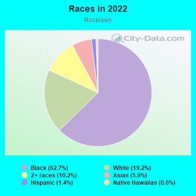
- 4,53162.7%Black
- 1,38719.2%White
- 74010.2%Two or more races
- 4235.9%Asian
- 981.4%Hispanic or Latino
- 460.6%Native Hawaiian and Other
Pacific Islander - 20.03%Some other race
Distribution of median household income
![Distribution of median household income]()
- 315Less than $10,000
- 665$10,000 to $19,999
- 306$20,000 to $29,999
- 338$30,000 to $39,999
- 432$40,000 to $49,999
- 277$50,000 to $59,999
- 131$60,000 to $74,999
- 221$75,000 to $99,999
- 136$100,000 to $124,999
- 109$125,000 to $149,999
- 125$150,000 to $199,999
- 76$200,000 or more

Distribution of owner-occupied house/condo value
![Distribution of owner-occupied house/condo value]()
- 316Less than $50,000
- 483$50,000 to $99,999
- 256$100,000 to $149,999
- 682$150,000 to $199,999
- 58$200,000 to $249,999
- 79$250,000 to $299,999
- 99$300,000 to $399,999
- 130$400,000 to $499,999
- 136$500,000 to $749,999
- 10$750,000 to $999,999
- 18$1,000,000 or more

Distribution of rent paid by renters
![Distribution of rent paid by renters]()
- 36Less than $100
- 324$200 to $299
- 549$300 to $399
- 364$400 to $499
- 297$500 to $599
- 281$600 to $699
- 1,112$700 to $799
- 298$800 to $899
- 296$900 to $999
- 255$1,000 to $1,249
- 168$1,250 to $1,499
- 36$1,500 to $1,999
- 22$2,000 or more

| Males: | 2,429 |
| Females: | 3,911 |
Males:
| This neighborhood: | 36.9 years |
| Whole city: | 32.7 years |
| This neighborhood: | 39.6 years |
| Whole city: | 34.2 years |
Average household size:
| Roselawn: | 5.3 people |
| Cincinnati: | 23.0 people |
Percentage of family households:
| Roselawn: | 50.3% |
| Cincinnati: | 33.3% |
| Here: | 22.7% |
| Cincinnati: | 23.1% |
Percentage of married-couple families with children (among all households):
| Roselawn: | 16.0% |
| Cincinnati: | 22.2% |
Percentage of single-mother households (among all households):
| Roselawn: | 25.3% |
| Cincinnati: | 22.0% |
Percentage of never married males 15 years old and over:
Percentage of never married females 15 years old and over:
| Roselawn: | 20.1% |
| Cincinnati: | 27.2% |
Percentage of never married females 15 years old and over:
| Roselawn: | 29.8% |
| city: | 29.6% |
Percentage of people that speak English not well or not at all:
| Roselawn: | 0.3% |
| Cincinnati: | 1.5% |
Percentage of people born in this state:
Percentage of people born in another U.S. state:
Percentage of native residents but born outside the U.S.:
Percentage of foreign born residents:
| Here: | 71.9% |
| Cincinnati: | 69.3% |
Percentage of people born in another U.S. state:
| Roselawn: | 22.3% |
| Cincinnati: | 23.5% |
Percentage of native residents but born outside the U.S.:
| Here: | 2.3% |
| city: | 1.0% |
Percentage of foreign born residents:
| Here: | 3.6% |
| Cincinnati: | 6.2% |
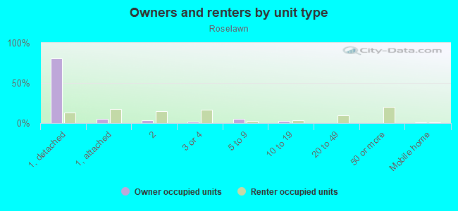
Owner-occupied
Renter-occupied

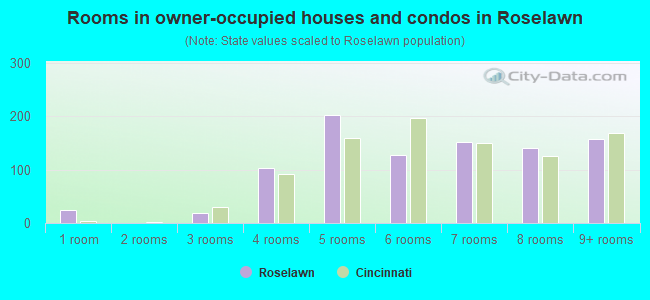
- Rooms in owner-occupied houses and condos in Roselawn
- 241 room
- 02 rooms
- 193 rooms
- 1034 rooms
- 2025 rooms
- 1276 rooms
- 1517 rooms
- 1418 rooms
- 1589+ rooms
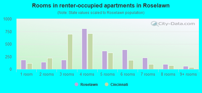
- Rooms in renter-occupied apartments in Roselawn
- 1881 room
- 1422 rooms
- 1883 rooms
- 8084 rooms
- 3635 rooms
- 3916 rooms
- 2287 rooms
- 998 rooms
- 609+ rooms
Owner-occupied
Renter-occupied
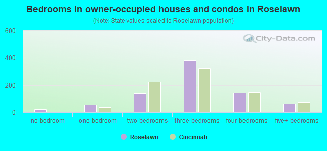
- Bedrooms in owner-occupied houses and condos in Roselawn
- 24no bedroom
- 561 bedroom
- 1422 bedrooms
- 3823 bedrooms
- 1454 bedrooms
- 645+ bedrooms
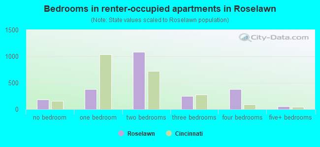
- Bedrooms in renter-occupied apartments in Roselawn
- 188no bedroom
- 3781 bedroom
- 1,0822 bedrooms
- 2523 bedrooms
- 3804 bedrooms
- 605+ bedrooms
Average number of cars or other vehicles available in houses/condos:
Average number of cars or other vehicles available in apartments:
| This neighborhood: | 2.1 |
| Cincinnati: | 1.9 |
Average number of cars or other vehicles available in apartments:
| Here: | 1.4 |
| city: | 1.0 |
Percentage of units with a mortgage:
| Roselawn: | 65.0% |
| Cincinnati: | 67.8% |
Average estimated value of detached houses in 2022 (38.5% of all units):
| Roselawn: | $98,690 |
| Ohio: | $254,366 |
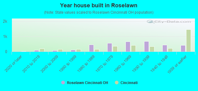
- Year house built in Roselawn
- 02020 or later
- 1002010 to 2019
- 772000 to 2009
- 1161990 to 1999
- 4631980 to 1989
- 5531970 to 1979
- 6571960 to 1969
- 6841950 to 1959
- 4411940 to 1949
- 4171939 or earlier
City-data.com crime index for city in 2020 (higher means more crime):
| City: | 490.1 |
| U.S. average: | 219.5 |
Travel time to work (commute)
![Travel time to work (commute)]()
- 136Less than 5 minutes
- 965 to 9 minutes
- 34410 to 14 minutes
- 46715 to 19 minutes
- 1,14920 to 24 minutes
- 19525 to 29 minutes
- 44730 to 34 minutes
- 11935 to 39 minutes
- 2140 to 44 minutes
- 9045 to 59 minutes
- 6560 to 89 minutes
- 19790 or more minutes

Means of transportation to work
![Means of transportation to work]()
- 79.2%2,351Drove a car alone
- 11.6%343Carpooled
- 6.6%195Bus
- 3.3%97Bicycle
- 1.9%55Walked
- 6.8%202Other means
- 3.2%94Worked at home

Time leaving home to go to work
![Time leaving home to go to work]()
- 3712:00 a.m. to 4:59 a.m.
- 735:00 a.m. to 5:29 a.m.
- 1335:30 a.m. to 5:59 a.m.
- 2306:00 a.m. to 6:29 a.m.
- 1486:30 a.m. to 6:59 a.m.
- 2957:00 a.m. to 7:29 a.m.
- 2537:30 a.m. to 7:59 a.m.
- 2898:00 a.m. to 8:29 a.m.
- 808:30 a.m. to 8:59 a.m.
- 3479:00 a.m. to 9:59 a.m.
- 13410:00 a.m. to 10:59 a.m.
- 7711:00 a.m. to 11:59 a.m.
- 45812:00 p.m. to 3:59 p.m.
- 4344:00 p.m. to 11:59 p.m.

Occupations of males:
- Percentage of males in management occupations (except farmers):
Here: 1.7% city: 11.2%
- Percentage of males in business and financial operations occupations:
Here: 13.8% city: 7.3%
- Percentage of males in computer and mathematical occupations:
Here: 5.5% city: 5.4%
- Percentage of males in community and social services occupations:
Here: 5.8% city: 1.8%
- Percentage of males in education, training, and library occupations:
Here: 4.2% city: 4.4%
- Percentage of males in arts, design, entertainment, sports, and media occupations:
Here: 3.3% city: 2.9%
- Percentage of males in healthcare practitioners and technical occupations:
Here: 1.8% city: 3.6%
- Percentage of males in service occupations:
Here: 28.1% city: 14.1%
- Percentage of males in sales and office occupations:
Here: 9.7% city: 15.7%
- Percentage of males in production occupations:
Here: 6.3% city: 6.1%
- Percentage of males in transportation occupations:
Here: 1.0% city: 4.4%
- Percentage of males in material moving occupations:
Here: 13.4% city: 8.4%
Occupations of females:
- Percentage of females in management occupations (except farmers):
Here: 4.9% city: 9.5%
- Percentage of females in business and financial operations occupations:
Here: 3.6% city: 6.1%
- Percentage of females in education, training, and library occupations:
Here: 1.7% city: 8.4%
- Percentage of females in healthcare practitioners and technical occupations:
Here: 1.8% city: 10.6%
- Percentage of females in service occupations:
Here: 45.0% city: 20.8%
- Percentage of females in sales and office occupations:
Here: 30.1% city: 23.8%
- Percentage of females in production occupations:
Here: 9.8% city: 4.0%
- Percentage of females in transportation occupations:
Here: 1.9% city: 1.4%
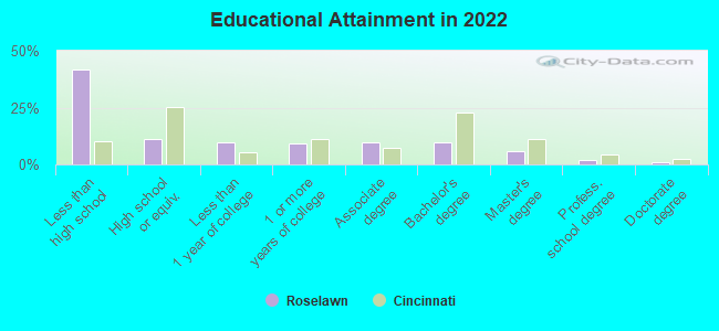
Education in this neighborhood (subdivision or community):
- Percentage of people 3 years and older in K-12 schools:
Roselawn: 32.0% Cincinnati: 15.0%
- Percentage of people 3 years and older in undergraduate colleges:
Roselawn: 4.1% Cincinnati: 10.0%
- Percentage of people 3 years and older in grad. or professional schools:
Roselawn: 0.8% Cincinnati: 3.0%
- Percentage of students K-12 enrolled in private schools:
Roselawn: 47.4% Cincinnati: 25.7%
Percentage of population below poverty level:
| Roselawn: | 35.0% |
| Cincinnati: | 26.6% |
Median year owner moved in (as recorded in 2022):
| Roselawn: | 2002 |
| Cincinnati: | 2011 |
Percentage of married-couple families with both working:
| Roselawn: | 124.5% |
| Cincinnati: | 77.0% |
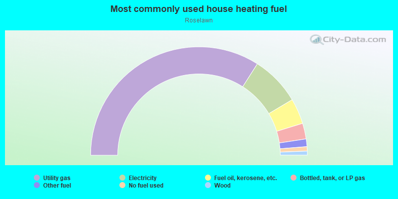
- 68.1%Utility gas
- 14.8%Electricity
- 7.6%Fuel oil, kerosene, etc.
- 4.7%Bottled, tank, or LP gas
- 2.3%Other fuel
- 1.3%No fuel used
- 1.2%Wood
Limited-access highways (interstate or state) in this neighborhood:
I- 75
Length: 0.39 miles
Direction: SW-NE
Direction: SW-NE
Highways in this neighborhood:
US Hwy 42 (Reading Rd)
Length: 1.48 miles
Direction: SW-NE
Address range: 7100 to 8146
Direction: SW-NE
Address range: 7100 to 8146
State Rte 126 (Ronald Reagan Cross County Hwy)
Length: 1.34 miles
Directions: E-W, SW-NE
Directions: E-W, SW-NE
State Rte 561 (Seymour Ave)
Length: 0.35 miles
Directions: E-W, SE-NW
Address range: 1600 to 1799
Directions: E-W, SE-NW
Address range: 1600 to 1799
State Rte 4 (Paddock Rd)
Length: 0.11 miles
Direction: N-S
Direction: N-S
Roads and streets:
Summit Rd
Length: 1.79 miles
Directions: E-W, SW-NE
Address range: 1100 to 1899
Directions: E-W, SW-NE
Address range: 1100 to 1899
Section Rd
Length: 1.15 miles
Directions: E-W, SE-NW
Address range: 1200 to 2099
Directions: E-W, SE-NW
Address range: 1200 to 2099
Greenland Pl
Length: 0.82 miles
Directions: N-S, SW-NE
Address range: 7500 to 7999
Directions: N-S, SW-NE
Address range: 7500 to 7999
Eastlawn Dr
Length: 0.57 miles
Directions: N-S, SE-NW, SW-NE
Address range: 7000 to 7399
Directions: N-S, SE-NW, SW-NE
Address range: 7000 to 7399
Stillwell Rd
Length: 0.54 miles
Direction: N-S
Address range: 7700 to 8199
Direction: N-S
Address range: 7700 to 8199
Losantiville Ave
Length: 0.54 miles
Direction: E-W
Address range: 1700 to 1952
Direction: E-W
Address range: 1700 to 1952
Shenandoah Ave
Length: 0.50 miles
Direction: E-W
Address range: 1400 to 1699
Direction: E-W
Address range: 1400 to 1699
Crest Hill Ave
Length: 0.46 miles
Direction: E-W
Address range: 1500 to 1899
Direction: E-W
Address range: 1500 to 1899
Reinhold Dr
Length: 0.42 miles
Directions: N-S, SW-NE
Address range: 7500 to 7799
Directions: N-S, SW-NE
Address range: 7500 to 7799
Brookcrest Dr
Length: 0.37 miles
Directions: N-S, SW-NE
Address range: 7200 to 7399
Directions: N-S, SW-NE
Address range: 7200 to 7399
Kenova Ave
Length: 0.37 miles
Directions: E-W, SE-NW
Address range: 1400 to 1599
Directions: E-W, SE-NW
Address range: 1400 to 1599
Northwood Dr
Length: 0.36 miles
Direction: E-W
Address range: 1500 to 1699
Direction: E-W
Address range: 1500 to 1699
Elm Shade Ave
Length: 0.34 miles
Direction: N-S
Address range: 7200 to 7455
Direction: N-S
Address range: 7200 to 7455
Sunnybrook Dr
Length: 0.34 miles
Directions: E-W, SE-NW
Address range: 1 to 1899
Directions: E-W, SE-NW
Address range: 1 to 1899
Corvallis Ave
Length: 0.32 miles
Direction: E-W
Address range: 1400 to 1599
Direction: E-W
Address range: 1400 to 1599
Scottwood Ave
Length: 0.32 miles
Directions: N-S, SW-NE
Address range: 7200 to 7399
Directions: N-S, SW-NE
Address range: 7200 to 7399
Parkdale Ave
Length: 0.32 miles
Directions: N-S, SW-NE
Address range: 7200 to 7499
Directions: N-S, SW-NE
Address range: 7200 to 7499
Woodland Ave
Length: 0.32 miles
Directions: E-W, SE-NW
Address range: 1200 to 1499
Directions: E-W, SE-NW
Address range: 1200 to 1499
Newbedford Ave
Length: 0.31 miles
Direction: N-S
Address range: 7700 to 7899
Direction: N-S
Address range: 7700 to 7899
Edgemont Rd
Length: 0.30 miles
Directions: E-W, N-S, SW-NE
Address range: 7400 to 7699
Directions: E-W, N-S, SW-NE
Address range: 7400 to 7699
Beaverton Ave
Length: 0.30 miles
Direction: E-W
Address range: 1400 to 1599
Direction: E-W
Address range: 1400 to 1599
Ross Ave
Length: 0.29 miles
Directions: E-W, N-S, SW-NE
Address range: 7400 to 7599
Directions: E-W, N-S, SW-NE
Address range: 7400 to 7599
Production Dr
Length: 0.28 miles
Directions: E-W, N-S, SE-NW
Address range: 7600 to 7699
Directions: E-W, N-S, SE-NW
Address range: 7600 to 7699
Summit East Ct
Length: 0.27 miles
Directions: E-W, N-S, SE-NW, SW-NE
Address range: 1 to 199
Directions: E-W, N-S, SE-NW, SW-NE
Address range: 1 to 199
Glen Orchard Dr
Length: 0.26 miles
Direction: N-S
Address range: 7800 to 7999
Direction: N-S
Address range: 7800 to 7999
Lakeland Ave
Length: 0.26 miles
Direction: E-W
Address range: 1400 to 1599
Direction: E-W
Address range: 1400 to 1599
Debonair Ct
Length: 0.26 miles
Directions: E-W, N-S, SE-NW
Address range: 8000 to 8199
Directions: E-W, N-S, SE-NW
Address range: 8000 to 8199
Larchwood Pl
Length: 0.24 miles
Direction: E-W
Address range: 1800 to 1899
Direction: E-W
Address range: 1800 to 1899
Miramar Ct
Length: 0.24 miles
Direction: E-W
Address range: 1500 to 1699
Direction: E-W
Address range: 1500 to 1699
Robinwood Ave
Length: 0.24 miles
Direction: E-W
Address range: 1400 to 1599
Direction: E-W
Address range: 1400 to 1599
Greenbriar Pl
Length: 0.22 miles
Direction: E-W
Address range: 1800 to 1899
Direction: E-W
Address range: 1800 to 1899
Castleton Pl
Length: 0.20 miles
Direction: N-S
Address range: 7500 to 7699
Direction: N-S
Address range: 7500 to 7699
Glendon Pl
Length: 0.19 miles
Directions: E-W, SE-NW
Address range: 1800 to 1899
Directions: E-W, SE-NW
Address range: 1800 to 1899
Blackstone Pl
Length: 0.17 miles
Direction: E-W
Address range: 1800 to 1899
Direction: E-W
Address range: 1800 to 1899
McClure Ave
Length: 0.17 miles
Directions: E-W, SE-NW
Address range: 1200 to 1399
Directions: E-W, SE-NW
Address range: 1200 to 1399
Dawn Rd
Length: 0.16 miles
Direction: N-S
Address range: 7800 to 7899
Direction: N-S
Address range: 7800 to 7899
Bluefield Pl
Length: 0.16 miles
Direction: E-W
Address range: 1800 to 1899
Direction: E-W
Address range: 1800 to 1899
Rosecliff Ave
Length: 0.16 miles
Direction: E-W
Address range: 1600 to 1699
Direction: E-W
Address range: 1600 to 1699
Wynnewood Ln
Length: 0.16 miles
Direction: E-W
Address range: 1800 to 1899
Direction: E-W
Address range: 1800 to 1899
Abbie Pl
Length: 0.15 miles
Direction: N-S
Address range: 7500 to 7599
Direction: N-S
Address range: 7500 to 7599
Sunfield Dr
Length: 0.15 miles
Direction: N-S
Address range: 7800 to 7999
Direction: N-S
Address range: 7800 to 7999
Lewis Dr
Length: 0.14 miles
Direction: E-W
Direction: E-W
Yorkshire Pl
Length: 0.13 miles
Direction: N-S
Address range: 7600 to 7699
Direction: N-S
Address range: 7600 to 7699
Stonybrook Dr
Length: 0.12 miles
Direction: E-W
Address range: 1700 to 1799
Direction: E-W
Address range: 1700 to 1799
Colmar Ln
Length: 0.12 miles
Direction: E-W
Address range: 1800 to 1899
Direction: E-W
Address range: 1800 to 1899
Amberlawn Ave
Length: 0.11 miles
Direction: E-W
Address range: 1800 to 1899
Direction: E-W
Address range: 1800 to 1899
Hartland Dr
Length: 0.10 miles
Direction: E-W
Direction: E-W
Shona Dr
Length: 0.08 miles
Directions: N-S, SW-NE
Address range: 7100 to 7199
Directions: N-S, SW-NE
Address range: 7100 to 7199
Sparkle Dr
Length: 0.08 miles
Direction: E-W
Address range: 1600 to 1699
Direction: E-W
Address range: 1600 to 1699
Pelham Pl
Length: 0.08 miles
Direction: E-W
Address range: 1600 to 1699
Direction: E-W
Address range: 1600 to 1699
Hurley Ave
Length: 0.07 miles
Directions: N-S, SE-NW
Address range: 1501 to 1599
Directions: N-S, SE-NW
Address range: 1501 to 1599
Don Rich Ct
Length: 0.07 miles
Direction: E-W
Address range: 1600 to 1699
Direction: E-W
Address range: 1600 to 1699
Griffin Dr
Length: 0.05 miles
Direction: N-S
Address range: 7500 to 7599
Direction: N-S
Address range: 7500 to 7599
Crestlawn Ave
Length: 0.04 miles
Direction: E-W
Direction: E-W
Elmshade Ave
Length: 0.03 miles
Direction: N-S
Direction: N-S
Railroad features:
Conrail RR
Length: 0.52 miles
Direction: SW-NE
Direction: SW-NE
Other features:
Mill Crk
Length: 1.06 miles
Directions: E-W, N-S, SW-NE
Directions: E-W, N-S, SW-NE