Riverside neighborhood in Rome, Georgia (GA), 30161, 30165 detailed profile
Settings
X


Business Search - 14 Million verified businesses
Area: 3.260 square miles
Population: 3,002
Population density:
| Riverside: | 921 people per square mile |
| Rome: | 1,280 people per square mile |

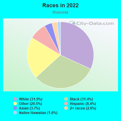
- 1,29831.9%White
- 1,27731.4%Black
- 83420.5%Some other race
- 3418.4%Hispanic or Latino
- 1493.7%Asian
- 1042.6%Two or more races
- 641.6%Native Hawaiian and Other
Pacific Islander
Median household income in 2022:
| Riverside: | $75,067 |
| Rome: | $48,512 |
Distribution of median household income
![Distribution of median household income]()
- 368Less than $10,000
- 380$10,000 to $19,999
- 208$20,000 to $29,999
- 127$30,000 to $39,999
- 318$40,000 to $49,999
- 98$50,000 to $59,999
- 74$60,000 to $74,999
- 90$75,000 to $99,999
- 48$100,000 to $124,999
- 43$125,000 to $149,999
- 47$150,000 to $199,999
- 159$200,000 or more

Distribution of owner-occupied house/condo value
![Distribution of owner-occupied house/condo value]()
- 434Less than $50,000
- 510$50,000 to $99,999
- 62$100,000 to $149,999
- 147$150,000 to $199,999
- 70$200,000 to $249,999
- 44$250,000 to $299,999
- 50$300,000 to $399,999
- 30$400,000 to $499,999
- 154$500,000 to $749,999
- 10$750,000 to $999,999
- 15$1,000,000 or more

Distribution of rent paid by renters
![Distribution of rent paid by renters]()
- 295Less than $100
- 734$100 to $199
- 1,397$200 to $299
- 1,023$300 to $399
- 552$400 to $499
- 344$500 to $599
- 175$600 to $699
- 260$700 to $799
- 80$800 to $899
- 55$900 to $999
- 322$1,000 to $1,249
- 112$1,250 to $1,499
- 179$1,500 to $1,999
- 50$2,000 or more

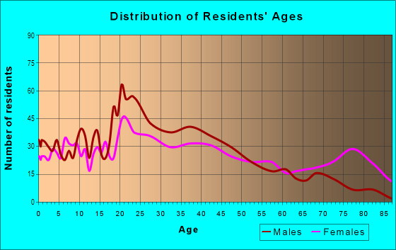
| Males: | 1,350 |
| Females: | 1,652 |
Males:
| This neighborhood: | 40.4 years |
| Whole city: | 36.1 years |
| This neighborhood: | 42.8 years |
| Whole city: | 37.9 years |
Average household size:
| Riverside: | 6.2 people |
| Rome: | 2.5 people |
Percentage of family households:
| Riverside: | 29.2% |
| Rome: | 45.4% |
| Here: | 11.6% |
| Rome: | 36.6% |
Percentage of married-couple families with children (among all households):
| Riverside: | 9.7% |
| Rome: | 22.4% |
Percentage of single-mother households (among all households):
| Riverside: | 52.0% |
| Rome: | 15.0% |
Percentage of never married males 15 years old and over:
Percentage of never married females 15 years old and over:
| Riverside: | 25.4% |
| Rome: | 19.0% |
Percentage of never married females 15 years old and over:
| Riverside: | 25.1% |
| city: | 20.3% |
Percentage of people that speak English not well or not at all:
| Riverside: | 2.0% |
| Rome: | 5.6% |
Percentage of people born in this state:
Percentage of people born in another U.S. state:
Percentage of native residents but born outside the U.S.:
Percentage of foreign born residents:
| Here: | 75.5% |
| Rome: | 66.1% |
Percentage of people born in another U.S. state:
| Riverside: | 20.3% |
| Rome: | 20.8% |
Percentage of native residents but born outside the U.S.:
| Here: | 0.6% |
| city: | 0.6% |
Percentage of foreign born residents:
| Here: | 3.6% |
| Rome: | 12.4% |
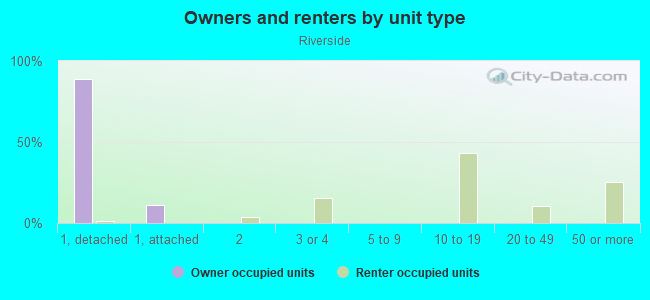
Owner-occupied
Renter-occupied

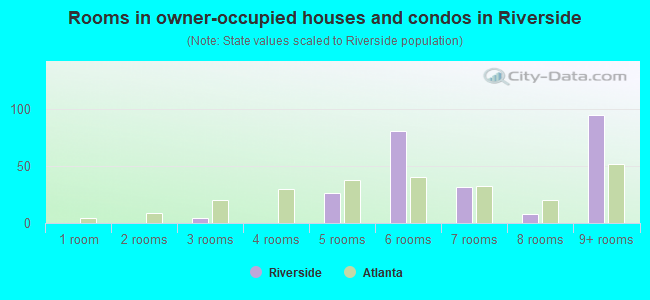
- Rooms in owner-occupied houses and condos in Riverside
- 01 room
- 22 rooms
- 323 rooms
- 334 rooms
- 825 rooms
- 1756 rooms
- 387 rooms
- 358 rooms
- 959+ rooms
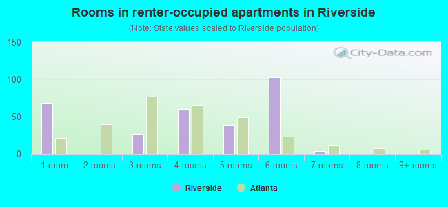
- Rooms in renter-occupied apartments in Riverside
- 6961 room
- 2552 rooms
- 2683 rooms
- 2154 rooms
- 1815 rooms
- 836 rooms
- 1757 rooms
- 1828 rooms
- 69+ rooms
Owner-occupied
Renter-occupied
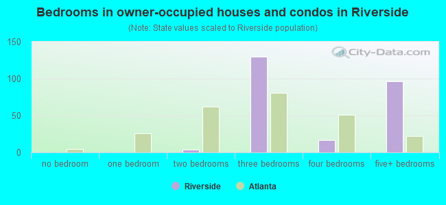
- Bedrooms in owner-occupied houses and condos in Riverside
- 0no bedroom
- 251 bedroom
- 1132 bedrooms
- 1803 bedrooms
- 274 bedrooms
- 1525+ bedrooms
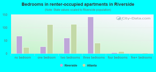
- Bedrooms in renter-occupied apartments in Riverside
- 696no bedroom
- 4391 bedroom
- 2542 bedrooms
- 2453 bedrooms
- 2804 bedrooms
- 05+ bedrooms
Average number of cars or other vehicles available in houses/condos:
Average number of cars or other vehicles available in apartments:
| This neighborhood: | 2.1 |
| Rome: | 2.1 |
Average number of cars or other vehicles available in apartments:
| Here: | 0.9 |
| city: | 1.0 |
Percentage of units with a mortgage:
| Riverside: | 52.9% |
| Rome: | 54.9% |
Average estimated value of detached houses in 2022 (40.2% of all units):
| Riverside: | $234,050 |
| Georgia: | $376,364 |
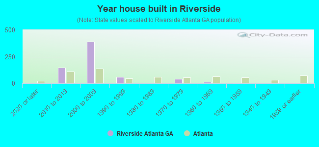
- Year house built in Riverside
- 132020 or later
- 4602010 to 2019
- 2392000 to 2009
- 1451990 to 1999
- 2211980 to 1989
- 3041970 to 1979
- 1211960 to 1969
- 2411950 to 1959
- 2121940 to 1949
- 4351939 or earlier
City-data.com crime index for city in 2020 (higher means more crime):
| City: | 213.7 |
| U.S. average: | 219.5 |
Travel time to work (commute)
![Travel time to work (commute)]()
- 111Less than 5 minutes
- 2035 to 9 minutes
- 28410 to 14 minutes
- 25815 to 19 minutes
- 8720 to 24 minutes
- 2625 to 29 minutes
- 20530 to 34 minutes
- 5835 to 39 minutes
- 3040 to 44 minutes
- 8045 to 59 minutes
- 2860 to 89 minutes
- 12590 or more minutes

Means of transportation to work
![Means of transportation to work]()
- 76.1%820Drove a car alone
- 4.8%52Carpooled
- 1.7%18Bus
- 0.2%2Ferryboat
- 0.6%6Taxi
- 0.6%7Bicycle
- 28.1%303Walked
- 10.2%110Other means
- 5.8%63Worked at home

Time leaving home to go to work
![Time leaving home to go to work]()
- 5812:00 a.m. to 4:59 a.m.
- 455:00 a.m. to 5:29 a.m.
- 905:30 a.m. to 5:59 a.m.
- 396:00 a.m. to 6:29 a.m.
- 806:30 a.m. to 6:59 a.m.
- 1767:00 a.m. to 7:29 a.m.
- 3137:30 a.m. to 7:59 a.m.
- 1358:00 a.m. to 8:29 a.m.
- 868:30 a.m. to 8:59 a.m.
- 269:00 a.m. to 9:59 a.m.
- 8710:00 a.m. to 10:59 a.m.
- 911:00 a.m. to 11:59 a.m.
- 11412:00 p.m. to 3:59 p.m.
- 1734:00 p.m. to 11:59 p.m.

Occupations of males:
- Percentage of males in management occupations (except farmers):
Here: 14.5% city: 10.2%
- Percentage of males in business and financial operations occupations:
Here: 2.5% city: 2.8%
- Percentage of males in computer and mathematical occupations:
Here: 2.5% city: 1.8%
- Percentage of males in architecture and engineering occupations:
Here: 4.1% city: 1.8%
- Percentage of males in education, training, and library occupations:
Here: 6.0% city: 4.0%
- Percentage of males in arts, design, entertainment, sports, and media occupations:
Here: 2.1% city: 2.7%
- Percentage of males in healthcare practitioners and technical occupations:
Here: 2.0% city: 4.1%
- Percentage of males in service occupations:
Here: 19.6% city: 18.0%
- Percentage of males in sales and office occupations:
Here: 14.7% city: 11.4%
- Percentage of males in construction, extraction, and maintenance occupations:
Here: 6.1% city: 10.3%
- Percentage of males in production occupations:
Here: 11.4% city: 15.0%
- Percentage of males in material moving occupations:
Here: 5.0% city: 5.6%
Occupations of females:
- Percentage of females in management occupations (except farmers):
Here: 4.5% city: 3.3%
- Percentage of females in business and financial operations occupations:
Here: 3.7% city: 5.1%
- Percentage of females in life, physical, and social science occupations:
Here: 1.0% city: 0.5%
- Percentage of females in community and social services occupations:
Here: 8.5% city: 3.5%
- Percentage of females in education, training, and library occupations:
Here: 2.3% city: 9.2%
- Percentage of females in healthcare practitioners and technical occupations:
Here: 6.7% city: 10.6%
- Percentage of females in service occupations:
Here: 42.9% city: 26.4%
- Percentage of females in sales and office occupations:
Here: 18.1% city: 23.6%
- Percentage of females in production occupations:
Here: 11.4% city: 9.7%
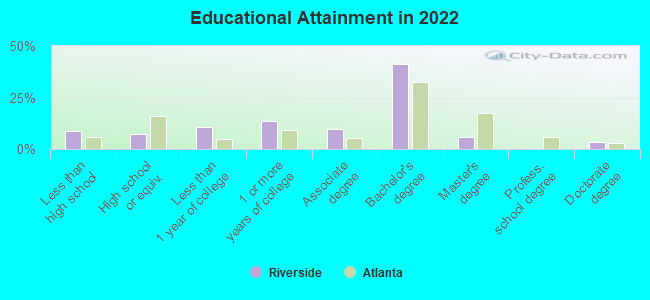
Education in this neighborhood (subdivision or community):
- Percentage of people 3 years and older in K-12 schools:
Riverside: 26.1% Rome: 18.8%
- Percentage of people 3 years and older in undergraduate colleges:
Riverside: 7.9% Rome: 4.7%
- Percentage of people 3 years and older in grad. or professional schools:
Riverside: 11.2% Rome: 1.0%
- Percentage of students K-12 enrolled in private schools:
Riverside: 64.5% Rome: 14.1%
Percentage of population below poverty level:
| Riverside: | 33.1% |
| Rome: | 22.2% |
Median year owner moved in (as recorded in 2022):
| Riverside: | 2008 |
| Rome: | 2008 |
Percentage of married-couple families with both working:
| Riverside: | 106.2% |
| Rome: | 68.1% |
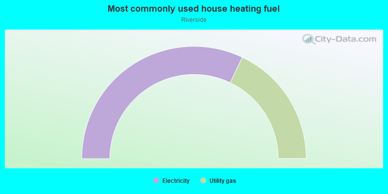
- 47.8%Electricity
- 34.7%Utility gas
- 5.3%Other fuel
- 5.1%No fuel used
- 3.7%Bottled, tank, or LP gas
- 2.3%Wood
- 1.1%Solar energy
Highways in this neighborhood:
State Loop 1 (E Rome Byp)
Length: 2.40 miles
Directions: E-W, SE-NW
Directions: E-W, SE-NW
New Calhoun Hwy NE (State Rte 53)
Length: 1.87 miles
Directions: N-S, SW-NE
Address range: 101 to 199
Directions: N-S, SW-NE
Address range: 101 to 199
State Rte 53 (N Broad St)
Length: 1.62 miles
Directions: N-S, SW-NE
Address range: 1000 to 2511
Directions: N-S, SW-NE
Address range: 1000 to 2511
State Rte 1 (US Hwy 27, Martha Berry Hwy)
Length: 1.41 miles
Directions: N-S, SE-NW
Address range: 700 to 1899
Directions: N-S, SE-NW
Address range: 700 to 1899
State Loop 1 (Veterans Memorial Pkwy NE)
Length: 1.32 miles
Directions: E-W, SW-NE
Address range: 1000 to 1020
Directions: E-W, SW-NE
Address range: 1000 to 1020
State Rte 1 (State Rte 20, US Hwy 27, Turner McCall Blvd)
Length: 1.23 miles
Directions: E-W, N-S, SE-NW
Address range: 300 to 1801
Directions: E-W, N-S, SE-NW
Address range: 300 to 1801
State Rte 293 (Martin Luther King Jr Blvd)
Length: 0.33 miles
Directions: E-W, SW-NE
Directions: E-W, SW-NE
State Rte 53 (N Broad St NE)
Length: 0.24 miles
Direction: SW-NE
Address range: 2300 to 2507
Direction: SW-NE
Address range: 2300 to 2507
State Loop 1 (Veterans Memorial Hwy NE)
Length: 0.06 miles
Directions: E-W, SW-NE
Directions: E-W, SW-NE
Roads and streets:
Calhoun Ave
Length: 1.45 miles
Directions: E-W, SW-NE
Address range: 4 to 1549
Directions: E-W, SW-NE
Address range: 4 to 1549
Bells Ferry Rd NE
Length: 0.98 miles
Directions: N-S, SW-NE
Address range: 1 to 99
Directions: N-S, SW-NE
Address range: 1 to 99
Ross St NE (W Ross St)
Length: 0.88 miles
Directions: N-S, SE-NW, SW-NE
Address range: 1 to 355
Directions: N-S, SE-NW, SW-NE
Address range: 1 to 355
Vaughn Rd
Length: 0.87 miles
Directions: E-W, N-S, SE-NW, SW-NE
Address range: 1 to 299
Directions: E-W, N-S, SE-NW, SW-NE
Address range: 1 to 299
Dogwood Dr
Length: 0.87 miles
Directions: E-W, N-S, SE-NW, SW-NE
Address range: 1 to 99
Directions: E-W, N-S, SE-NW, SW-NE
Address range: 1 to 99
Calhoun Hwy NE (Calhoun Rd NE)
Length: 0.71 miles
Directions: E-W, SW-NE
Address range: 1528 to 1847
Directions: E-W, SW-NE
Address range: 1528 to 1847
Stansbury St
Length: 0.63 miles
Directions: E-W, N-S, SE-NW, SW-NE
Address range: 1 to 199
Directions: E-W, N-S, SE-NW, SW-NE
Address range: 1 to 199
Gibbons St
Length: 0.63 miles
Directions: N-S, SW-NE
Address range: 1 to 199
Directions: N-S, SW-NE
Address range: 1 to 199
Riverside Pkwy NE
Length: 0.61 miles
Direction: N-S
Address range: 400 to 487
Direction: N-S
Address range: 400 to 487
North Ave
Length: 0.58 miles
Direction: SE-NW
Address range: 201 to 599
Direction: SE-NW
Address range: 201 to 599
Tolbert St
Length: 0.57 miles
Directions: N-S, SE-NW, SW-NE
Address range: 200 to 499
Directions: N-S, SE-NW, SW-NE
Address range: 200 to 499
Reservoir St
Length: 0.55 miles
Directions: E-W, N-S, SE-NW, SW-NE
Address range: 1 to 399
Directions: E-W, N-S, SE-NW, SW-NE
Address range: 1 to 399
Reece St
Length: 0.54 miles
Directions: N-S, SW-NE
Address range: 1 to 599
Directions: N-S, SW-NE
Address range: 1 to 599
Rudy St
Length: 0.52 miles
Directions: N-S, SW-NE
Address range: 1 to 399
Directions: N-S, SW-NE
Address range: 1 to 399
Ave B
Length: 0.50 miles
Direction: N-S
Address range: 700 to 1399
Direction: N-S
Address range: 700 to 1399
Southern St
Length: 0.50 miles
Directions: E-W, SW-NE
Address range: 2000 to 2299
Directions: E-W, SW-NE
Address range: 2000 to 2299
N 5th Ave
Length: 0.50 miles
Directions: N-S, SE-NW
Address range: 700 to 1399
Directions: N-S, SE-NW
Address range: 700 to 1399
Woodward St
Length: 0.47 miles
Directions: N-S, SE-NW, SW-NE
Address range: 100 to 499
Directions: N-S, SE-NW, SW-NE
Address range: 100 to 499
W 10th St
Length: 0.46 miles
Direction: E-W
Address range: 300 to 699
Direction: E-W
Address range: 300 to 699
W 11th St
Length: 0.46 miles
Directions: E-W, SW-NE
Address range: 200 to 699
Directions: E-W, SW-NE
Address range: 200 to 699
Burton Rd NE
Length: 0.42 miles
Directions: E-W, N-S, SE-NW, SW-NE
Address range: 1 to 199
Directions: E-W, N-S, SE-NW, SW-NE
Address range: 1 to 199
Ave A
Length: 0.39 miles
Directions: N-S, SE-NW
Address range: 700 to 1199
Directions: N-S, SE-NW
Address range: 700 to 1199
Reynolds St
Length: 0.38 miles
Directions: N-S, SW-NE
Address range: 100 to 399
Directions: N-S, SW-NE
Address range: 100 to 399
W 12th St
Length: 0.36 miles
Direction: E-W
Address range: 500 to 699
Direction: E-W
Address range: 500 to 699
W 9th St
Length: 0.36 miles
Direction: E-W
Address range: 300 to 699
Direction: E-W
Address range: 300 to 699
Forsyth St
Length: 0.36 miles
Direction: SW-NE
Address range: 1 to 499
Direction: SW-NE
Address range: 1 to 499
Howell St
Length: 0.34 miles
Directions: E-W, SW-NE
Address range: 1 to 399
Directions: E-W, SW-NE
Address range: 1 to 399
Pine St
Length: 0.34 miles
Directions: N-S, SW-NE
Address range: 1 to 399
Directions: N-S, SW-NE
Address range: 1 to 399
King Bee Cir
Length: 0.33 miles
Directions: E-W, N-S, SE-NW, SW-NE
Address range: 1 to 198
Directions: E-W, N-S, SE-NW, SW-NE
Address range: 1 to 198
Couper St
Length: 0.33 miles
Direction: SW-NE
Address range: 1 to 399
Direction: SW-NE
Address range: 1 to 399
Civic Center Dr
Length: 0.33 miles
Directions: E-W, N-S, SE-NW, SW-NE
Address range: 400 to 499
Directions: E-W, N-S, SE-NW, SW-NE
Address range: 400 to 499
W Callahan St
Length: 0.33 miles
Directions: E-W, SE-NW
Address range: 1 to 299
Directions: E-W, SE-NW
Address range: 1 to 299
W 13th St
Length: 0.32 miles
Direction: E-W
Address range: 500 to 599
Direction: E-W
Address range: 500 to 599
Harvey St
Length: 0.32 miles
Direction: E-W
Address range: 1 to 199
Direction: E-W
Address range: 1 to 199
Kingston Ave NE
Length: 0.32 miles
Direction: E-W
Address range: 1 to 199
Direction: E-W
Address range: 1 to 199
Clervue Cir NE
Length: 0.31 miles
Directions: E-W, N-S, SE-NW, SW-NE
Address range: 4 to 99
Directions: E-W, N-S, SE-NW, SW-NE
Address range: 4 to 99
Wright St
Length: 0.30 miles
Directions: E-W, SE-NW
Address range: 1 to 398
Directions: E-W, SE-NW
Address range: 1 to 398
Euclid Ave
Length: 0.30 miles
Direction: SE-NW
Address range: 1 to 499
Direction: SE-NW
Address range: 1 to 499
Smith St
Length: 0.29 miles
Directions: N-S, SW-NE
Address range: 1 to 299
Directions: N-S, SW-NE
Address range: 1 to 299
Reservation St
Length: 0.28 miles
Directions: E-W, N-S, SE-NW, SW-NE
Address range: 1 to 299
Directions: E-W, N-S, SE-NW, SW-NE
Address range: 1 to 299
W 8th St
Length: 0.28 miles
Direction: E-W
Address range: 300 to 699
Direction: E-W
Address range: 300 to 699
Bell View Dr NE
Length: 0.27 miles
Directions: E-W, N-S, SE-NW, SW-NE
Address range: 1 to 99
Directions: E-W, N-S, SE-NW, SW-NE
Address range: 1 to 99
Camp St
Length: 0.26 miles
Directions: E-W, SW-NE
Address range: 1 to 399
Directions: E-W, SW-NE
Address range: 1 to 399
Reservior St
Length: 0.25 miles
Direction: E-W
Direction: E-W
Roseway Cir
Length: 0.25 miles
Directions: E-W, N-S, SE-NW, SW-NE
Address range: 1 to 199
Directions: E-W, N-S, SE-NW, SW-NE
Address range: 1 to 199
Jackson St
Length: 0.24 miles
Directions: N-S, SE-NW
Address range: 1 to 199
Directions: N-S, SE-NW
Address range: 1 to 199
Superba Ave
Length: 0.23 miles
Direction: SE-NW
Address range: 400 to 599
Direction: SE-NW
Address range: 400 to 599
Davis St
Length: 0.23 miles
Directions: E-W, SE-NW
Address range: 1 to 20
Directions: E-W, SE-NW
Address range: 1 to 20
Ross St
Length: 0.23 miles
Directions: E-W, N-S, SE-NW, SW-NE
Directions: E-W, N-S, SE-NW, SW-NE
Cybertyme Ln
Length: 0.22 miles
Directions: E-W, SE-NW, SW-NE
Directions: E-W, SE-NW, SW-NE
Lindberg Dr
Length: 0.22 miles
Directions: E-W, N-S, SE-NW, SW-NE
Address range: 1 to 99
Directions: E-W, N-S, SE-NW, SW-NE
Address range: 1 to 99
Palmore St
Length: 0.21 miles
Direction: N-S
Address range: 1 to 99
Direction: N-S
Address range: 1 to 99
Heard St
Length: 0.20 miles
Directions: N-S, SW-NE
Address range: 1 to 99
Directions: N-S, SW-NE
Address range: 1 to 99
Duke St
Length: 0.20 miles
Directions: E-W, SE-NW
Address range: 1 to 99
Directions: E-W, SE-NW
Address range: 1 to 99
Superba Ave NE
Length: 0.20 miles
Direction: SE-NW
Address range: 100 to 399
Direction: SE-NW
Address range: 100 to 399
Broad St
Length: 0.19 miles
Direction: E-W
Address range: 900 to 1005
Direction: E-W
Address range: 900 to 1005
Stevens St
Length: 0.19 miles
Direction: SE-NW
Address range: 1 to 99
Direction: SE-NW
Address range: 1 to 99
Cooperage St NE
Length: 0.19 miles
Direction: SE-NW
Direction: SE-NW
Evans St
Length: 0.19 miles
Direction: SE-NW
Address range: 1 to 299
Direction: SE-NW
Address range: 1 to 299
Dale St
Length: 0.18 miles
Directions: E-W, N-S, SE-NW, SW-NE
Address range: 1 to 199
Directions: E-W, N-S, SE-NW, SW-NE
Address range: 1 to 199
Russell St
Length: 0.17 miles
Direction: SE-NW
Address range: 1 to 99
Direction: SE-NW
Address range: 1 to 99
Foster Ave NE
Length: 0.16 miles
Directions: E-W, N-S, SE-NW, SW-NE
Address range: 1 to 99
Directions: E-W, N-S, SE-NW, SW-NE
Address range: 1 to 99
E Callahan St
Length: 0.16 miles
Direction: SE-NW
Address range: 1 to 199
Direction: SE-NW
Address range: 1 to 199
Dwinell St
Length: 0.16 miles
Directions: E-W, N-S, SW-NE
Address range: 1 to 15
Directions: E-W, N-S, SW-NE
Address range: 1 to 15
Rainbow Cir NE
Length: 0.15 miles
Directions: E-W, N-S, SE-NW, SW-NE
Address range: 1 to 99
Directions: E-W, N-S, SE-NW, SW-NE
Address range: 1 to 99
Whatley St
Length: 0.15 miles
Directions: E-W, SE-NW
Address range: 1 to 99
Directions: E-W, SE-NW
Address range: 1 to 99
Chester Ave
Length: 0.15 miles
Directions: N-S, SE-NW
Address range: 1 to 99
Directions: N-S, SE-NW
Address range: 1 to 99
W 1st St
Length: 0.15 miles
Direction: E-W
Address range: 900 to 999
Direction: E-W
Address range: 900 to 999
Copeland St
Length: 0.15 miles
Direction: SW-NE
Address range: 1 to 99
Direction: SW-NE
Address range: 1 to 99
Burnett St
Length: 0.14 miles
Direction: SE-NW
Address range: 1 to 199
Direction: SE-NW
Address range: 1 to 199
Middle St
Length: 0.13 miles
Direction: N-S
Address range: 1 to 99
Direction: N-S
Address range: 1 to 99
Watters St
Length: 0.13 miles
Directions: E-W, N-S, SW-NE
Directions: E-W, N-S, SW-NE
Merriam St
Length: 0.13 miles
Directions: E-W, N-S, SE-NW, SW-NE
Address range: 1 to 99
Directions: E-W, N-S, SE-NW, SW-NE
Address range: 1 to 99
4th Ave
Length: 0.13 miles
Direction: N-S
Address range: 700 to 799
Direction: N-S
Address range: 700 to 799
Keelway Dr
Length: 0.12 miles
Direction: N-S
Address range: 700 to 899
Direction: N-S
Address range: 700 to 899
Earl Ln
Length: 0.12 miles
Direction: SW-NE
Address range: 100 to 199
Direction: SW-NE
Address range: 100 to 199
Anderson St NE
Length: 0.11 miles
Direction: SE-NW
Address range: 1 to 199
Direction: SE-NW
Address range: 1 to 199
Oostanaula Dr
Length: 0.10 miles
Direction: E-W
Address range: 100 to 205
Direction: E-W
Address range: 100 to 205
Henry St
Length: 0.09 miles
Directions: E-W, SW-NE
Directions: E-W, SW-NE
Berrien St
Length: 0.09 miles
Directions: E-W, SW-NE
Address range: 1 to 99
Directions: E-W, SW-NE
Address range: 1 to 99
Mc Donald St
Length: 0.09 miles
Directions: E-W, SW-NE
Address range: 501 to 699
Directions: E-W, SW-NE
Address range: 501 to 699
Link St
Length: 0.09 miles
Direction: SW-NE
Address range: 700 to 799
Direction: SW-NE
Address range: 700 to 799
Ragan St
Length: 0.08 miles
Direction: E-W
Direction: E-W
Hunter St
Length: 0.08 miles
Directions: E-W, SE-NW
Address range: 1 to 99
Directions: E-W, SE-NW
Address range: 1 to 99
Arthur Ln
Length: 0.07 miles
Directions: N-S, SW-NE
Directions: N-S, SW-NE
Gardner Dr
Length: 0.07 miles
Directions: E-W, N-S, SE-NW
Address range: 1 to 99
Directions: E-W, N-S, SE-NW
Address range: 1 to 99
Perkins St
Length: 0.06 miles
Direction: SE-NW
Direction: SE-NW
Huran St
Length: 0.06 miles
Direction: SE-NW
Direction: SE-NW
Bale St
Length: 0.06 miles
Direction: E-W
Direction: E-W
Maxwell Ln
Length: 0.05 miles
Direction: N-S
Direction: N-S
Griffin St
Length: 0.05 miles
Direction: E-W
Address range: 1 to 199
Direction: E-W
Address range: 1 to 199
Alford St
Length: 0.05 miles
Directions: E-W, SW-NE
Address range: 1 to 99
Directions: E-W, SW-NE
Address range: 1 to 99
Jackson Hill Dr
Length: 0.05 miles
Direction: SE-NW
Address range: 1 to 99
Direction: SE-NW
Address range: 1 to 99
Reservoir Dr
Length: 0.04 miles
Directions: N-S, SW-NE
Directions: N-S, SW-NE
Dodd St
Length: 0.04 miles
Direction: SE-NW
Direction: SE-NW
Clervue Cir
Length: 0.04 miles
Direction: SE-NW
Address range: 1 to 99
Direction: SE-NW
Address range: 1 to 99
Opportunity Dr
Length: 0.03 miles
Direction: E-W
Direction: E-W
Railroad features:
Southern Rlwy
Length: 4.91 miles
Directions: E-W, N-S, SE-NW, SW-NE
Directions: E-W, N-S, SE-NW, SW-NE
Norfolk Southern Corporation RR
Length: 1.46 miles
Directions: E-W, SW-NE
Directions: E-W, SW-NE
Other features:
Burwell Crk
Length: 1.46 miles
Directions: E-W, N-S, SE-NW, SW-NE
Directions: E-W, N-S, SE-NW, SW-NE
Little Dry Crk
Length: 0.06 miles
Directions: E-W, SE-NW
Directions: E-W, SE-NW