Riverside neighborhood in Cleveland, Ohio (OH), 44135, 44142 detailed profile
Settings
X


Business Search - 14 Million verified businesses
Area: 4.931 square miles
Population: 66,855
Population density:
| Riverside: | 13,559 people per square mile |
| Cleveland: | 4,662 people per square mile |

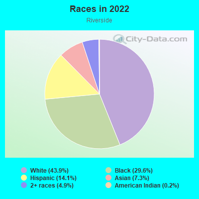
- 29,76243.9%White
- 20,07229.6%Black
- 9,57414.1%Hispanic or Latino
- 4,9367.3%Asian
- 3,3204.9%Two or more races
- 1070.2%American Indian
Distribution of median household income
![Distribution of median household income]()
- 8,492Less than $10,000
- 5,488$10,000 to $19,999
- 2,956$20,000 to $29,999
- 2,271$30,000 to $39,999
- 2,386$40,000 to $49,999
- 1,013$50,000 to $59,999
- 1,727$60,000 to $74,999
- 4,521$75,000 to $99,999
- 3,190$100,000 to $124,999
- 2,263$125,000 to $149,999
- 775$150,000 to $199,999
- 397$200,000 or more

Distribution of owner-occupied house/condo value
![Distribution of owner-occupied house/condo value]()
- 2,269Less than $50,000
- 6,397$50,000 to $99,999
- 7,031$100,000 to $149,999
- 1,970$150,000 to $199,999
- 1,786$200,000 to $249,999
- 1,180$250,000 to $299,999
- 39$300,000 to $399,999
- 287$400,000 to $499,999
- 491$500,000 to $749,999
- 54$750,000 to $999,999
- 88$1,000,000 or more

Distribution of rent paid by renters
![Distribution of rent paid by renters]()
- 1,929Less than $100
- 16,133$100 to $199
- 1,423$200 to $299
- 7,499$300 to $399
- 1,521$400 to $499
- 7,805$500 to $599
- 1,488$600 to $699
- 763$700 to $799
- 1,193$800 to $899
- 740$900 to $999
- 943$1,000 to $1,249
- 689$1,250 to $1,499
- 58$1,500 to $1,999

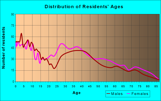
| Males: | 30,935 |
| Females: | 35,920 |
Males:
| This neighborhood: | |
| Whole city: |
| This neighborhood: | |
| Whole city: |
Percentage of family households:
| Riverside: | 44.6% |
| Cleveland: | 32.3% |
| Here: | 22.1% |
| Cleveland: | 18.6% |
Percentage of married-couple families with children (among all households):
| Riverside: | 11.3% |
| Cleveland: | 10.0% |
Percentage of single-mother households (among all households):
| Riverside: | 23.4% |
| Cleveland: | 30.3% |
Percentage of never married males 15 years old and over:
Percentage of never married females 15 years old and over:
| Riverside: | 26.8% |
| Cleveland: | 27.7% |
Percentage of never married females 15 years old and over:
| Riverside: | 25.5% |
| city: | 26.3% |
Percentage of people that speak English not well or not at all:
| Riverside: | 2.6% |
| Cleveland: | 2.7% |
Percentage of people born in this state:
Percentage of people born in another U.S. state:
Percentage of native residents but born outside the U.S.:
Percentage of foreign born residents:
| Here: | 76.1% |
| Cleveland: | 71.5% |
Percentage of people born in another U.S. state:
| Riverside: | 12.5% |
| Cleveland: | 17.9% |
Percentage of native residents but born outside the U.S.:
| Here: | 3.2% |
| city: | 4.3% |
Percentage of foreign born residents:
| Here: | 8.1% |
| Cleveland: | 6.3% |
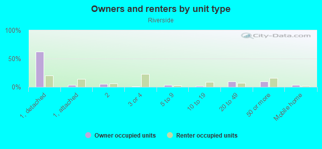
Owner-occupied
Renter-occupied

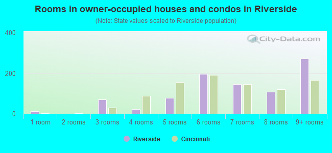
- Rooms in owner-occupied houses and condos in Riverside
- 01 room
- 3302 rooms
- 7753 rooms
- 1,8164 rooms
- 4,2035 rooms
- 4,2056 rooms
- 2,4327 rooms
- 1,5688 rooms
- 1,9689+ rooms
- Rooms in renter-occupied apartments in Riverside
- 321 room
- 4632 rooms
- 3,1893 rooms
- 5,3044 rooms
- 3,3295 rooms
- 2,6406 rooms
- 8507 rooms
- 1,1448 rooms
- 4009+ rooms
Owner-occupied
Renter-occupied
- Bedrooms in owner-occupied houses and condos in Riverside
- 0no bedroom
- 3561 bedroom
- 3,2572 bedrooms
- 9,3373 bedrooms
- 2,4324 bedrooms
- 6095+ bedrooms
- Bedrooms in renter-occupied apartments in Riverside
- 32no bedroom
- 2,4771 bedroom
- 5,9852 bedrooms
- 4,0393 bedrooms
- 1,7244 bedrooms
- 1,7445+ bedrooms
Average number of cars or other vehicles available in houses/condos:
Average number of cars or other vehicles available in apartments:
| This neighborhood: | |
| Cleveland: |
Average number of cars or other vehicles available in apartments:
| Here: | |
| city: |
Percentage of units with a mortgage:
| Riverside: | 61.0% |
| Cleveland: | 50.7% |
- Year house built in Riverside
- 3,7642020 or later
- 3,0422010 to 2019
- 1,0882000 to 2009
- 1,3201990 to 1999
- 1,4661980 to 1989
- 2,3521970 to 1979
- 4,3921960 to 1969
- 7,0661950 to 1959
- 3,5461940 to 1949
- 5,8831939 or earlier
City-data.com crime index for city in 2020 (higher means more crime):
| City: | 735.3 |
| U.S. average: | 219.5 |
Travel time to work (commute)
![Travel time to work (commute)]()
- 454Less than 5 minutes
- 2955 to 9 minutes
- 38910 to 14 minutes
- 65015 to 19 minutes
- 45420 to 24 minutes
- 21725 to 29 minutes
- 34130 to 34 minutes
- 6035 to 39 minutes
- 5540 to 44 minutes
- 1,33545 to 59 minutes
- 11960 to 89 minutes
- 5090 or more minutes

Means of transportation to work
![Means of transportation to work]()
- 72.9%19,378Drove a car alone
- 22.0%5,858Carpooled
- 4.6%1,216Bus
- 0.3%68Subway or elevated rail
- 0.2%53Long-distance train or commuter rail
- 0.2%41Taxi
- 0.4%110Bicycle
- 0.3%85Walked
- 0.2%53Other means
- 7.0%1,854Worked at home

Time leaving home to go to work
![Time leaving home to go to work]()
- 15312:00 a.m. to 4:59 a.m.
- 2565:00 a.m. to 5:29 a.m.
- 1275:30 a.m. to 5:59 a.m.
- 1156:00 a.m. to 6:29 a.m.
- 1216:30 a.m. to 6:59 a.m.
- 5707:00 a.m. to 7:29 a.m.
- 2417:30 a.m. to 7:59 a.m.
- 2978:00 a.m. to 8:29 a.m.
- 988:30 a.m. to 8:59 a.m.
- 2439:00 a.m. to 9:59 a.m.
- 2510:00 a.m. to 10:59 a.m.
- 11011:00 a.m. to 11:59 a.m.
- 20712:00 p.m. to 3:59 p.m.
- 7424:00 p.m. to 11:59 p.m.

Occupations of males:
- Percentage of males in management occupations (except farmers):
Here: 7.7% city: 7.3%
- Percentage of males in business and financial operations occupations:
Here: 6.6% city: 4.6%
- Percentage of males in computer and mathematical occupations:
Here: 1.8% city: 3.6%
- Percentage of males in life, physical, and social science occupations:
Here: 1.1% city: 1.2%
- Percentage of males in community and social services occupations:
Here: 2.6% city: 1.4%
- Percentage of males in service occupations:
Here: 22.8% city: 20.2%
- Percentage of males in sales and office occupations:
Here: 14.0% city: 14.2%
- Percentage of males in construction, extraction, and maintenance occupations:
Here: 4.8% city: 6.7%
- Percentage of males in production occupations:
Here: 12.1% city: 10.8%
- Percentage of males in transportation occupations:
Here: 4.6% city: 5.8%
- Percentage of males in material moving occupations:
Here: 10.5% city: 9.1%
Occupations of females:
- Percentage of females in management occupations (except farmers):
Here: 7.0% city: 6.9%
- Percentage of females in business and financial operations occupations:
Here: 6.0% city: 5.8%
- Percentage of females in computer and mathematical occupations:
Here: 1.6% city: 1.6%
- Percentage of females in community and social services occupations:
Here: 3.8% city: 2.8%
- Percentage of females in education, training, and library occupations:
Here: 2.9% city: 5.8%
- Percentage of females in healthcare practitioners and technical occupations:
Here: 10.5% city: 9.3%
- Percentage of females in service occupations:
Here: 11.5% city: 26.3%
- Percentage of females in sales and office occupations:
Here: 44.8% city: 27.0%
- Percentage of females in production occupations:
Here: 4.4% city: 5.0%
- Percentage of females in material moving occupations:
Here: 3.4% city: 2.6%
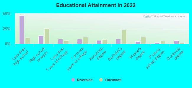
Education in this neighborhood (subdivision or community):
- Percentage of people 3 years and older in K-12 schools:
Riverside: 38.0% Cleveland: 15.5%
- Percentage of people 3 years and older in undergraduate colleges:
Riverside: 7.4% Cleveland: 5.1%
- Percentage of people 3 years and older in grad. or professional schools:
Riverside: 2.0% Cleveland: 1.7%
- Percentage of students K-12 enrolled in private schools:
Riverside: 83.7% Cleveland: 22.4%
Percentage of population below poverty level:
| Riverside: | 35.5% |
| Cleveland: | 31.8% |
Percentage of married-couple families with both working:
| Riverside: | 182.1% |
| Cleveland: | 72.0% |
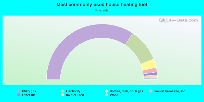
- 79.4%Utility gas
- 11.5%Other fuel
- 3.2%Electricity
- 3.1%Bottled, tank, or LP gas
- 1.5%No fuel used
- 1.3%Fuel oil, kerosene, etc.
Limited-access highways (interstate or state) in this neighborhood:
Outerbelt South Fwy (I- 480)
Length: 2.22 miles
Directions: E-W, SE-NW
Directions: E-W, SE-NW
I- 71
Length: 0.82 miles
Direction: SW-NE
Direction: SW-NE
Highways in this neighborhood:
Brookpark Rd (State Rte 17)
Length: 1.84 miles
Direction: E-W
Address range: 18018 to 20599
Direction: E-W
Address range: 18018 to 20599
Rocky River Dr (State Rte 237)
Length: 1.49 miles
Directions: N-S, SE-NW, SW-NE
Address range: 4466 to 4997
Directions: N-S, SE-NW, SW-NE
Address range: 4466 to 4997
Berea Fwy (State Rte 237)
Length: 1.35 miles
Directions: N-S, SW-NE
Directions: N-S, SW-NE
Roads and streets:
Parkmount Ave
Length: 1.68 miles
Directions: E-W, N-S, SE-NW, SW-NE
Address range: 17400 to 19999
Directions: E-W, N-S, SE-NW, SW-NE
Address range: 17400 to 19999
Grayton Rd
Length: 1.42 miles
Directions: N-S, SE-NW, SW-NE
Address range: 4550 to 6273
Directions: N-S, SE-NW, SW-NE
Address range: 4550 to 6273
Aerospace Pkwy
Length: 1.31 miles
Directions: E-W, SW-NE
Address range: 22468 to 22999
Directions: E-W, SW-NE
Address range: 22468 to 22999
Ixcenter Dr
Length: 1.26 miles
Directions: E-W, N-S, SE-NW
Directions: E-W, N-S, SE-NW
Midvale Ave
Length: 1.23 miles
Direction: E-W
Address range: 17600 to 20299
Direction: E-W
Address range: 17600 to 20299
Fairville Ave
Length: 1.02 miles
Direction: E-W
Address range: 17400 to 19199
Direction: E-W
Address range: 17400 to 19199
Forestwood Ave
Length: 0.86 miles
Directions: E-W, SE-NW, SW-NE
Address range: 18300 to 19811
Directions: E-W, SE-NW, SW-NE
Address range: 18300 to 19811
Flamingo Ave
Length: 0.85 miles
Directions: E-W, SE-NW
Address range: 17400 to 18799
Directions: E-W, SE-NW
Address range: 17400 to 18799
Ponciana Ave
Length: 0.84 miles
Direction: E-W
Address range: 17400 to 18799
Direction: E-W
Address range: 17400 to 18799
Maplewood Ave
Length: 0.79 miles
Direction: E-W
Address range: 18500 to 19799
Direction: E-W
Address range: 18500 to 19799
Homeway Rd
Length: 0.72 miles
Directions: E-W, N-S, SE-NW
Address range: 18300 to 19399
Directions: E-W, N-S, SE-NW
Address range: 18300 to 19399
Ferncliffe Ave
Length: 0.52 miles
Direction: E-W
Address range: 18200 to 18999
Direction: E-W
Address range: 18200 to 18999
Springdale Ave
Length: 0.51 miles
Direction: E-W
Address range: 18500 to 19199
Direction: E-W
Address range: 18500 to 19199
Cleveland Pkwy
Length: 0.48 miles
Direction: E-W
Address range: 17800 to 18399
Direction: E-W
Address range: 17800 to 18399
Rockland Ave
Length: 0.48 miles
Direction: E-W
Address range: 18200 to 18999
Direction: E-W
Address range: 18200 to 18999
Brysdale Ave
Length: 0.47 miles
Direction: E-W
Address range: 17600 to 18399
Direction: E-W
Address range: 17600 to 18399
W 185th St
Length: 0.46 miles
Direction: N-S
Address range: 4458 to 4799
Direction: N-S
Address range: 4458 to 4799
W 192nd St
Length: 0.40 miles
Direction: N-S
Address range: 4533 to 4851
Direction: N-S
Address range: 4533 to 4851
Glenshire Ave
Length: 0.34 miles
Direction: E-W
Address range: 17400 to 17999
Direction: E-W
Address range: 17400 to 17999
Postal Rd
Length: 0.33 miles
Directions: E-W, SW-NE
Directions: E-W, SW-NE
W 190th St
Length: 0.33 miles
Directions: E-W, N-S, SE-NW
Address range: 4500 to 4799
Directions: E-W, N-S, SE-NW
Address range: 4500 to 4799
Grayton (Old Grayton Rd)
Length: 0.33 miles
Direction: SW-NE
Address range: 4800 to 4999
Direction: SW-NE
Address range: 4800 to 4999
Hipple Ave
Length: 0.32 miles
Directions: E-W, SW-NE
Address range: 19200 to 19699
Directions: E-W, SW-NE
Address range: 19200 to 19699
W 198th St
Length: 0.30 miles
Directions: E-W, N-S, SW-NE
Address range: 4700 to 4999
Directions: E-W, N-S, SW-NE
Address range: 4700 to 4999
Cargo Rd
Length: 0.29 miles
Direction: SW-NE
Address range: 5800 to 6199
Direction: SW-NE
Address range: 5800 to 6199
Cyclone Dr
Length: 0.26 miles
Direction: E-W
Address range: 19300 to 19599
Direction: E-W
Address range: 19300 to 19599
Apelt Ave (Apelt Dr)
Length: 0.22 miles
Direction: E-W
Address range: 19100 to 19499
Direction: E-W
Address range: 19100 to 19499
W 180th St
Length: 0.22 miles
Direction: N-S
Address range: 4550 to 4899
Direction: N-S
Address range: 4550 to 4899
Hillside Rd
Length: 0.21 miles
Direction: E-W
Address range: 20300 to 20999
Direction: E-W
Address range: 20300 to 20999
Martha Rd
Length: 0.21 miles
Directions: E-W, SW-NE
Address range: 16800 to 17399
Directions: E-W, SW-NE
Address range: 16800 to 17399
Weyburne Ave
Length: 0.20 miles
Directions: E-W, SW-NE
Address range: 19300 to 19799
Directions: E-W, SW-NE
Address range: 19300 to 19799
Cedar Point Rd
Length: 0.19 miles
Direction: SE-NW
Address range: 22000 to 22099
Direction: SE-NW
Address range: 22000 to 22099
W 194th St
Length: 0.19 miles
Direction: N-S
Address range: 4500 to 4599
Direction: N-S
Address range: 4500 to 4599
W 188th St
Length: 0.18 miles
Direction: N-S
Address range: 4700 to 4851
Direction: N-S
Address range: 4700 to 4851
W 174th St
Length: 0.16 miles
Direction: N-S
Address range: 4430 to 4651
Direction: N-S
Address range: 4430 to 4651
W 193rd St
Length: 0.16 miles
Direction: N-S
Address range: 4500 to 4699
Direction: N-S
Address range: 4500 to 4699
W 191st St
Length: 0.15 miles
Directions: N-S, SE-NW, SW-NE
Address range: 4461 to 4499
Directions: N-S, SE-NW, SW-NE
Address range: 4461 to 4499
Harwell Rd
Length: 0.14 miles
Directions: N-S, SW-NE
Address range: 4730 to 17712
Directions: N-S, SW-NE
Address range: 4730 to 17712
Emerald Ct SW
Length: 0.13 miles
Directions: E-W, N-S
Address range: 4900 to 4999
Directions: E-W, N-S
Address range: 4900 to 4999
Kilson Ave
Length: 0.12 miles
Direction: E-W
Address range: 19300 to 19445
Direction: E-W
Address range: 19300 to 19445
W 177th St
Length: 0.11 miles
Direction: N-S
Address range: 4450 to 4569
Direction: N-S
Address range: 4450 to 4569
W 202nd St
Length: 0.10 miles
Directions: N-S, SE-NW
Address range: 4700 to 20116
Directions: N-S, SE-NW
Address range: 4700 to 20116
W 183rd St
Length: 0.06 miles
Direction: N-S
Address range: 4600 to 4753
Direction: N-S
Address range: 4600 to 4753
Puritas Park Dr
Length: 0.06 miles
Directions: N-S, SE-NW
Address range: 4500 to 4599
Directions: N-S, SE-NW
Address range: 4500 to 4599
W 196th St
Length: 0.06 miles
Directions: N-S, SE-NW
Address range: 4600 to 4885
Directions: N-S, SE-NW
Address range: 4600 to 4885
Big Met Pl
Length: 0.05 miles
Direction: N-S
Address range: 4500 to 4599
Direction: N-S
Address range: 4500 to 4599
Little Met Pl
Length: 0.05 miles
Direction: N-S
Address range: 4500 to 4599
Direction: N-S
Address range: 4500 to 4599
W 197th St
Length: 0.05 miles
Direction: N-S
Address range: 4600 to 4799
Direction: N-S
Address range: 4600 to 4799
W 195th St
Length: 0.02 miles
Direction: N-S
Direction: N-S
Railroad features:
Csx RR (Conrail RR)
Length: 0.39 miles
Direction: E-W
Direction: E-W
Other features:
Abram Crk
Length: 2.33 miles
Directions: E-W, N-S, SE-NW, SW-NE
Directions: E-W, N-S, SE-NW, SW-NE
Rocky Riv
Length: 0.22 miles
Directions: E-W, N-S
Directions: E-W, N-S