Orange Mound neighborhood in Memphis, Tennessee (TN), 38111, 38114 detailed profile
Settings
X

Business Search - 14 Million verified businesses
Area: 1.310 square miles
Population: 5,242
Population density:
| Orange Mound: | 4,001 people per square mile |
| Memphis: | 2,223 people per square mile |

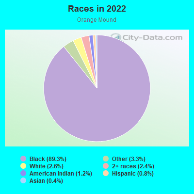
- 5,07489.3%Black
- 1853.3%Some other race
- 1502.6%White
- 1392.4%Two or more races
- 661.2%American Indian
- 470.8%Hispanic or Latino
- 230.4%Asian
Distribution of median household income
![Distribution of median household income]()
- 463Less than $10,000
- 455$10,000 to $19,999
- 591$20,000 to $29,999
- 485$30,000 to $39,999
- 366$40,000 to $49,999
- 118$50,000 to $59,999
- 424$60,000 to $74,999
- 191$75,000 to $99,999
- 121$100,000 to $124,999
- 76$125,000 to $149,999
- 64$150,000 to $199,999
- 140$200,000 or more

Distribution of owner-occupied house/condo value
![Distribution of owner-occupied house/condo value]()
- 1,009Less than $50,000
- 897$50,000 to $99,999
- 270$100,000 to $149,999
- 348$150,000 to $199,999
- 230$200,000 to $249,999
- 274$250,000 to $299,999
- 176$300,000 to $399,999
- 57$400,000 to $499,999
- 103$500,000 to $749,999
- 305$750,000 to $999,999
- 416$1,000,000 or more

Distribution of rent paid by renters
![Distribution of rent paid by renters]()
- 436$100 to $199
- 190$200 to $299
- 614$300 to $399
- 465$400 to $499
- 451$500 to $599
- 515$600 to $699
- 923$700 to $799
- 129$800 to $899
- 103$900 to $999
- 296$1,000 to $1,249
- 188$1,250 to $1,499
- 77$2,000 or more

Median rent in 2022:
| Orange Mound: | $530 |
| Memphis: | $817 |
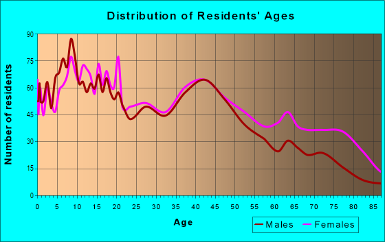
| Males: | 2,557 |
| Females: | 2,684 |
Males:
| This neighborhood: | 39.2 years |
| Whole city: | 33.4 years |
| This neighborhood: | 43.6 years |
| Whole city: | 36.2 years |
Average household size:
| Orange Mound: | 2.3 people |
| Memphis: | 2.4 people |
Percentage of family households:
| Orange Mound: | 36.6% |
| Memphis: | 40.8% |
| Here: | 21.3% |
| Memphis: | 26.4% |
Percentage of married-couple families with children (among all households):
| Orange Mound: | 5.9% |
| Memphis: | 15.4% |
Percentage of single-mother households (among all households):
| Orange Mound: | 27.5% |
| Memphis: | 21.2% |
Percentage of never married males 15 years old and over:
Percentage of never married females 15 years old and over:
| Orange Mound: | 27.5% |
| Memphis: | 24.0% |
Percentage of never married females 15 years old and over:
| Orange Mound: | 28.0% |
| city: | 24.7% |
Percentage of people that speak English not well or not at all:
| Orange Mound: | 0.0% |
| Memphis: | 2.3% |
Percentage of people born in this state:
Percentage of people born in another U.S. state:
Percentage of native residents but born outside the U.S.:
Percentage of foreign born residents:
| Here: | 75.8% |
| Memphis: | 64.2% |
Percentage of people born in another U.S. state:
| Orange Mound: | 23.8% |
| Memphis: | 27.8% |
Percentage of native residents but born outside the U.S.:
| Here: | 0.4% |
| city: | 0.7% |
Percentage of foreign born residents:
| Here: | 0.4% |
| Memphis: | 7.2% |
Owner-occupied
Renter-occupied

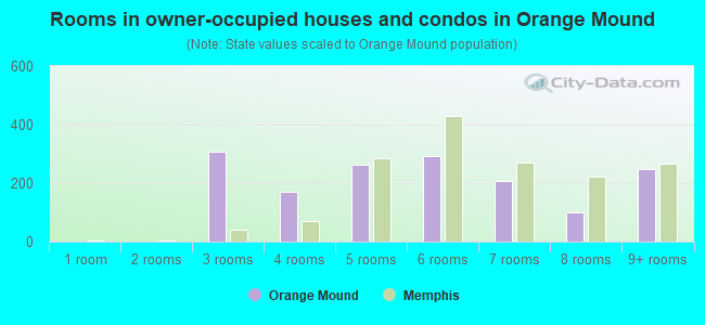
- Rooms in owner-occupied houses and condos in Orange Mound
- 01 room
- 02 rooms
- 3083 rooms
- 1714 rooms
- 2635 rooms
- 2916 rooms
- 2067 rooms
- 1018 rooms
- 2479+ rooms
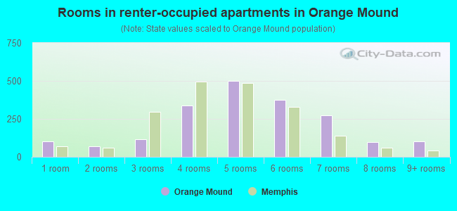
- Rooms in renter-occupied apartments in Orange Mound
- 1041 room
- 702 rooms
- 1183 rooms
- 3384 rooms
- 5015 rooms
- 3776 rooms
- 2737 rooms
- 958 rooms
- 1029+ rooms
Owner-occupied
Renter-occupied
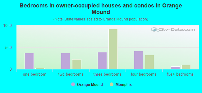
- Bedrooms in owner-occupied houses and condos in Orange Mound
- 0no bedroom
- 3661 bedroom
- 3702 bedrooms
- 3893 bedrooms
- 4194 bedrooms
- 635+ bedrooms
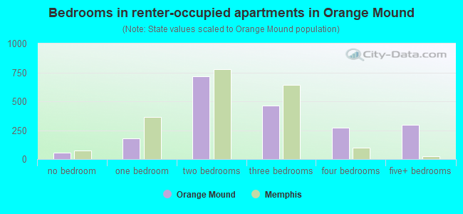
- Bedrooms in renter-occupied apartments in Orange Mound
- 58no bedroom
- 1821 bedroom
- 7182 bedrooms
- 4633 bedrooms
- 2704 bedrooms
- 2995+ bedrooms
Average number of cars or other vehicles available in houses/condos:
Average number of cars or other vehicles available in apartments:
| This neighborhood: | 1.6 |
| Memphis: | 1.9 |
Average number of cars or other vehicles available in apartments:
| Here: | 1.2 |
| city: | 1.3 |
Percentage of units with a mortgage:
| Orange Mound: | 43.1% |
| Memphis: | 58.8% |
Average estimated value of detached houses in 2022 (71.3% of all units):
| Orange Mound: | $93,174 |
| Memphis: | $212,707 |
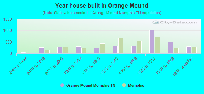
- Year house built in Orange Mound
- 362020 or later
- 2632010 to 2019
- 2722000 to 2009
- 3021990 to 1999
- 2401980 to 1989
- 3181970 to 1979
- 3311960 to 1969
- 1,0371950 to 1959
- 4991940 to 1949
- 3051939 or earlier
City-data.com crime index for city in 2020 (higher means more crime):
| City: | 897.5 |
| U.S. average: | 219.5 |
Travel time to work (commute)
![Travel time to work (commute)]()
- 17Less than 5 minutes
- 2005 to 9 minutes
- 28310 to 14 minutes
- 43215 to 19 minutes
- 60320 to 24 minutes
- 8225 to 29 minutes
- 23830 to 34 minutes
- 3935 to 39 minutes
- 2340 to 44 minutes
- 11545 to 59 minutes
- 1560 to 89 minutes
- 14590 or more minutes

Means of transportation to work
![Means of transportation to work]()
- 70.6%1,414Drove a car alone
- 19.0%381Carpooled
- 11.8%236Bus
- 0.3%6Taxi
- 1.9%38Bicycle
- 3.8%76Walked
- 15.1%303Other means
- 7.8%156Worked at home

Time leaving home to go to work
![Time leaving home to go to work]()
- 13012:00 a.m. to 4:59 a.m.
- 395:00 a.m. to 5:29 a.m.
- 495:30 a.m. to 5:59 a.m.
- 806:00 a.m. to 6:29 a.m.
- 2036:30 a.m. to 6:59 a.m.
- 1787:00 a.m. to 7:29 a.m.
- 1817:30 a.m. to 7:59 a.m.
- 2298:00 a.m. to 8:29 a.m.
- 1078:30 a.m. to 8:59 a.m.
- 749:00 a.m. to 9:59 a.m.
- 23010:00 a.m. to 10:59 a.m.
- 11511:00 a.m. to 11:59 a.m.
- 40512:00 p.m. to 3:59 p.m.
- 2124:00 p.m. to 11:59 p.m.

Occupations of males:
- Percentage of males in management occupations (except farmers):
Here: 2.9% city: 8.6%
- Percentage of males in legal occupations:
Here: 1.8% city: 1.1%
- Percentage of males in service occupations:
Here: 24.5% city: 15.9%
- Percentage of males in sales and office occupations:
Here: 24.3% city: 15.1%
- Percentage of males in construction, extraction, and maintenance occupations:
Here: 1.9% city: 8.1%
- Percentage of males in production occupations:
Here: 11.4% city: 7.6%
- Percentage of males in transportation occupations:
Here: 4.1% city: 7.7%
- Percentage of males in material moving occupations:
Here: 25.8% city: 13.5%
Occupations of females:
- Percentage of females in management occupations (except farmers):
Here: 11.2% city: 8.0%
- Percentage of females in education, training, and library occupations:
Here: 8.1% city: 7.8%
- Percentage of females in healthcare practitioners and technical occupations:
Here: 1.9% city: 7.9%
- Percentage of females in service occupations:
Here: 20.5% city: 20.2%
- Percentage of females in sales and office occupations:
Here: 31.5% city: 28.5%
- Percentage of females in transportation occupations:
Here: 3.6% city: 1.6%
- Percentage of females in material moving occupations:
Here: 21.8% city: 7.8%
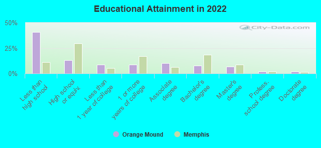
Education in this neighborhood (subdivision or community):
- Percentage of people 3 years and older in K-12 schools:
Orange Mound: 25.4% Memphis: 18.0%
- Percentage of people 3 years and older in undergraduate colleges:
Orange Mound: 13.2% Memphis: 3.5%
- Percentage of people 3 years and older in grad. or professional schools:
Orange Mound: 3.2% Memphis: 2.2%
- Percentage of students K-12 enrolled in private schools:
Orange Mound: 50.0% Memphis: 10.3%
Percentage of population below poverty level:
| Orange Mound: | 31.4% |
| Memphis: | 21.4% |
Percentage of married-couple families with both working:
| Orange Mound: | 232.9% |
| Memphis: | 70.5% |
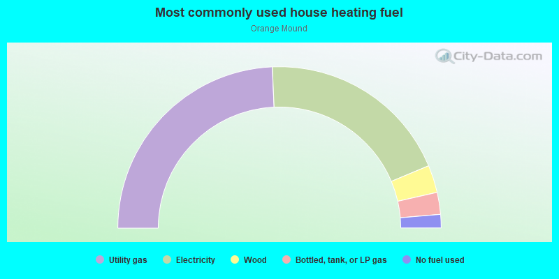
- 48.6%Utility gas
- 38.8%Electricity
- 5.5%Wood
- 4.4%Bottled, tank, or LP gas
- 2.7%No fuel used
Highways in this neighborhood:
State Hwy 4 (US Hwy 78, Lamar Ave)
Length: 0.40 miles
Directions: E-W, SE-NW
Address range: 2208 to 2649
Directions: E-W, SE-NW
Address range: 2208 to 2649
State Hwy 277 (Airways Blvd)
Length: 0.39 miles
Directions: N-S, SE-NW, SW-NE
Address range: 1230 to 1440
Directions: N-S, SE-NW, SW-NE
Address range: 1230 to 1440
Roads and streets:
Park Ave
Length: 1.71 miles
Directions: E-W, SW-NE
Address range: 2200 to 2961
Directions: E-W, SW-NE
Address range: 2200 to 2961
Buntyn St
Length: 1.66 miles
Directions: N-S, SE-NW
Address range: 230 to 1632
Directions: N-S, SE-NW
Address range: 230 to 1632
Douglass Ave
Length: 1.51 miles
Direction: E-W
Address range: 2286 to 2967
Direction: E-W
Address range: 2286 to 2967
Carnes Ave
Length: 1.37 miles
Directions: E-W, SW-NE
Address range: 2333 to 2959
Directions: E-W, SW-NE
Address range: 2333 to 2959
Spottswood Ave
Length: 1.20 miles
Directions: E-W, SE-NW
Address range: 2435 to 2955
Directions: E-W, SE-NW
Address range: 2435 to 2955
Pendleton St
Length: 1.19 miles
Direction: N-S
Address range: 623 to 1746
Direction: N-S
Address range: 623 to 1746
Boston St
Length: 1.15 miles
Directions: N-S, SW-NE
Address range: 293 to 1050
Directions: N-S, SW-NE
Address range: 293 to 1050
Deadrick Ave
Length: 1.03 miles
Directions: E-W, SW-NE
Address range: 2340 to 2798
Directions: E-W, SW-NE
Address range: 2340 to 2798
David St
Length: 0.95 miles
Directions: E-W, N-S, SE-NW
Address range: 700 to 1709
Directions: E-W, N-S, SE-NW
Address range: 700 to 1709
Hamilton St
Length: 0.94 miles
Directions: N-S, SE-NW
Address range: 647 to 1626
Directions: N-S, SE-NW
Address range: 647 to 1626
Baltimore St
Length: 0.90 miles
Directions: N-S, SE-NW
Address range: 463 to 1632
Directions: N-S, SE-NW
Address range: 463 to 1632
Cella St
Length: 0.79 miles
Directions: E-W, N-S, SE-NW
Address range: 700 to 1606
Directions: E-W, N-S, SE-NW
Address range: 700 to 1606
Marianna St
Length: 0.73 miles
Direction: N-S
Address range: 625 to 1633
Direction: N-S
Address range: 625 to 1633
Select Ave
Length: 0.72 miles
Direction: E-W
Address range: 2372 to 2799
Direction: E-W
Address range: 2372 to 2799
Marechalneil St
Length: 0.65 miles
Direction: N-S
Address range: 647 to 1478
Direction: N-S
Address range: 647 to 1478
Supreme Ave
Length: 0.63 miles
Directions: E-W, SE-NW
Address range: 2320 to 2799
Directions: E-W, SE-NW
Address range: 2320 to 2799
Josephine St
Length: 0.60 miles
Directions: N-S, SW-NE
Address range: 613 to 886
Directions: N-S, SW-NE
Address range: 613 to 886
Dallas St
Length: 0.58 miles
Directions: N-S, SW-NE
Address range: 700 to 1635
Directions: N-S, SW-NE
Address range: 700 to 1635
Barron Ave
Length: 0.56 miles
Directions: E-W, SW-NE
Address range: 2525 to 2779
Directions: E-W, SW-NE
Address range: 2525 to 2779
Grand St
Length: 0.55 miles
Direction: N-S
Address range: 700 to 1462
Direction: N-S
Address range: 700 to 1462
Waverly Ave
Length: 0.53 miles
Directions: E-W, SE-NW
Address range: 2695 to 2898
Directions: E-W, SE-NW
Address range: 2695 to 2898
Brooklyn Ave
Length: 0.49 miles
Directions: E-W, SE-NW
Address range: 2277 to 2499
Directions: E-W, SE-NW
Address range: 2277 to 2499
Goodwyn St
Length: 0.47 miles
Direction: N-S
Address range: 612 to 899
Direction: N-S
Address range: 612 to 899
Enterprise Ave
Length: 0.45 miles
Direction: E-W
Address range: 2290 to 2799
Direction: E-W
Address range: 2290 to 2799
Hanley St
Length: 0.41 miles
Direction: N-S
Address range: 647 to 878
Direction: N-S
Address range: 647 to 878
Fizer Rd
Length: 0.39 miles
Direction: E-W
Address range: 2600 to 2777
Direction: E-W
Address range: 2600 to 2777
Inez St
Length: 0.38 miles
Direction: N-S
Address range: 672 to 899
Direction: N-S
Address range: 672 to 899
Saratoga Ave
Length: 0.37 miles
Direction: E-W
Address range: 2320 to 2499
Direction: E-W
Address range: 2320 to 2499
S Hollywood St
Length: 0.36 miles
Direction: N-S
Address range: 422 to 603
Direction: N-S
Address range: 422 to 603
Zanone Ave
Length: 0.35 miles
Direction: E-W
Address range: 2321 to 2499
Direction: E-W
Address range: 2321 to 2499
Cable Ave
Length: 0.35 miles
Direction: E-W
Address range: 2295 to 2499
Direction: E-W
Address range: 2295 to 2499
Haynes St
Length: 0.35 miles
Directions: N-S, SE-NW, SW-NE
Address range: 625 to 884
Directions: N-S, SE-NW, SW-NE
Address range: 625 to 884
Midland Ave
Length: 0.31 miles
Direction: E-W
Address range: 2565 to 2707
Direction: E-W
Address range: 2565 to 2707
Felix Ave
Length: 0.30 miles
Direction: E-W
Address range: 2576 to 2707
Direction: E-W
Address range: 2576 to 2707
Southern Ave
Length: 0.30 miles
Direction: E-W
Address range: 2578 to 2707
Direction: E-W
Address range: 2578 to 2707
Belt Line St
Length: 0.29 miles
Direction: N-S
Address range: 439 to 613
Direction: N-S
Address range: 439 to 613
Hilton St
Length: 0.27 miles
Direction: N-S
Address range: 721 to 866
Direction: N-S
Address range: 721 to 866
Hugenot St
Length: 0.27 miles
Direction: N-S
Address range: 1471 to 1626
Direction: N-S
Address range: 1471 to 1626
Laurel St
Length: 0.25 miles
Direction: N-S
Address range: 733 to 886
Direction: N-S
Address range: 733 to 886
Ethel St
Length: 0.24 miles
Direction: N-S
Address range: 874 to 1465
Direction: N-S
Address range: 874 to 1465
Tunstall St
Length: 0.24 miles
Direction: N-S
Address range: 877 to 1476
Direction: N-S
Address range: 877 to 1476
Keating St
Length: 0.24 miles
Direction: N-S
Address range: 874 to 1478
Direction: N-S
Address range: 874 to 1478
Raymond St
Length: 0.24 miles
Direction: N-S
Address range: 877 to 1435
Direction: N-S
Address range: 877 to 1435
Kent St
Length: 0.22 miles
Direction: N-S
Address range: 619 to 761
Direction: N-S
Address range: 619 to 761
Hodges St
Length: 0.21 miles
Direction: N-S
Address range: 294 to 450
Direction: N-S
Address range: 294 to 450
Choctaw Ave
Length: 0.18 miles
Direction: E-W
Address range: 2813 to 2918
Direction: E-W
Address range: 2813 to 2918
Bey St
Length: 0.16 miles
Direction: N-S
Address range: 700 to 799
Direction: N-S
Address range: 700 to 799
Sample St
Length: 0.14 miles
Direction: N-S
Address range: 1283 to 1382
Direction: N-S
Address range: 1283 to 1382
Maywood St
Length: 0.14 miles
Direction: N-S
Address range: 789 to 886
Direction: N-S
Address range: 789 to 886
Milton Ave
Length: 0.14 miles
Directions: E-W, SW-NE
Address range: 2649 to 2999
Directions: E-W, SW-NE
Address range: 2649 to 2999
Central Ter
Length: 0.14 miles
Directions: E-W, N-S, SE-NW, SW-NE
Address range: 2654 to 2705
Directions: E-W, N-S, SE-NW, SW-NE
Address range: 2654 to 2705
Bruce St
Length: 0.13 miles
Direction: N-S
Address range: 1262 to 1366
Direction: N-S
Address range: 1262 to 1366
Young Ave
Length: 0.13 miles
Direction: E-W
Address range: 2565 to 2641
Direction: E-W
Address range: 2565 to 2641
Walker Ave
Length: 0.13 miles
Direction: E-W
Address range: 2565 to 2638
Direction: E-W
Address range: 2565 to 2638
Central Ave
Length: 0.11 miles
Direction: SE-NW
Address range: 2668 to 2699
Direction: SE-NW
Address range: 2668 to 2699
Whittington St
Length: 0.11 miles
Direction: N-S
Address range: 648 to 726
Direction: N-S
Address range: 648 to 726
Mound St
Length: 0.11 miles
Direction: N-S
Address range: 649 to 723
Direction: N-S
Address range: 649 to 723
S Trezevant St
Length: 0.10 miles
Directions: N-S, SW-NE
Address range: 1200 to 1489
Directions: N-S, SW-NE
Address range: 1200 to 1489
E Brentwood Cir
Length: 0.09 miles
Directions: N-S, SW-NE
Address range: 600 to 799
Directions: N-S, SW-NE
Address range: 600 to 799
W Brentwood Cir
Length: 0.08 miles
Direction: N-S
Address range: 600 to 799
Direction: N-S
Address range: 600 to 799
Spottswood Ct
Length: 0.08 miles
Direction: N-S
Address range: 2600 to 2883
Direction: N-S
Address range: 2600 to 2883
Belt Line Cove
Length: 0.08 miles
Direction: E-W
Address range: 2590 to 2629
Direction: E-W
Address range: 2590 to 2629
S Brentwood Cir
Length: 0.08 miles
Directions: E-W, N-S, SE-NW, SW-NE
Address range: 2815 to 2867
Directions: E-W, N-S, SE-NW, SW-NE
Address range: 2815 to 2867
Progress Ave
Length: 0.07 miles
Direction: E-W
Address range: 2320 to 2374
Direction: E-W
Address range: 2320 to 2374
Thurman St
Length: 0.07 miles
Direction: N-S
Direction: N-S
Lombardy Pl
Length: 0.07 miles
Directions: E-W, SW-NE
Address range: 200 to 299
Directions: E-W, SW-NE
Address range: 200 to 299
Lamar Cove
Length: 0.06 miles
Direction: N-S
Address range: 1480 to 1550
Direction: N-S
Address range: 1480 to 1550
Lombardy Ave
Length: 0.05 miles
Direction: E-W
Address range: 2670 to 2709
Direction: E-W
Address range: 2670 to 2709
Lamar Cir
Length: 0.04 miles
Direction: E-W
Address range: 2299 to 2463
Direction: E-W
Address range: 2299 to 2463
Railroad features:
Southern Rlwy
Length: 3.03 miles
Direction: E-W
Direction: E-W
Illinois Central RR
Length: 0.26 miles
Direction: SW-NE
Direction: SW-NE
Other features:
Cypress Crk
Length: 0.50 miles
Directions: N-S, SW-NE
Directions: N-S, SW-NE
Belt Line Br
Length: 0.48 miles
Directions: E-W, SW-NE
Directions: E-W, SW-NE