Oakwood Beach neighborhood in Staten Island, New York (NY), 10306 detailed profile
Settings
X


Business Search - 14 Million verified businesses
Area: 1.025 square miles
Population: 17,353
Population density:
| Oakwood Beach: | 16,929 people per square mile |
| Staten Island: | 7,588 people per square mile |

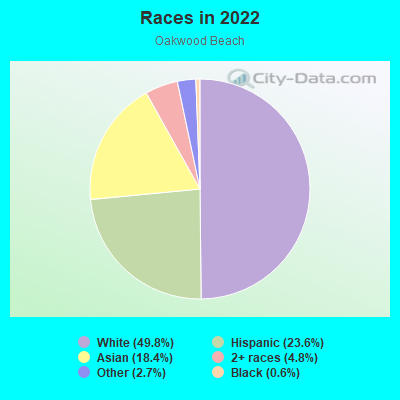
- 8,81649.8%White
- 4,18423.6%Hispanic or Latino
- 3,25118.4%Asian
- 8544.8%Two or more races
- 4842.7%Some other race
- 1150.6%Black
Median household income in 2022:
| Oakwood Beach: | $89,521 |
| New York: | $79,557 |
Distribution of median household income
![Distribution of median household income]()
- 187Less than $10,000
- 274$10,000 to $19,999
- 233$20,000 to $29,999
- 309$30,000 to $39,999
- 276$40,000 to $49,999
- 374$50,000 to $59,999
- 879$60,000 to $74,999
- 839$75,000 to $99,999
- 514$100,000 to $124,999
- 193$125,000 to $149,999
- 639$150,000 to $199,999
- 1,003$200,000 or more

Distribution of owner-occupied house/condo value
![Distribution of owner-occupied house/condo value]()
- 66Less than $50,000
- 50$50,000 to $99,999
- 139$150,000 to $199,999
- 80$200,000 to $249,999
- 77$250,000 to $299,999
- 437$300,000 to $399,999
- 470$400,000 to $499,999
- 2,508$500,000 to $749,999
- 289$750,000 to $999,999
- 288$1,000,000 or more

Distribution of rent paid by renters
![Distribution of rent paid by renters]()
- 46$200 to $299
- 60$300 to $399
- 192$600 to $699
- 525$700 to $799
- 391$800 to $899
- 620$900 to $999
- 541$1,000 to $1,249
- 185$1,250 to $1,499
- 192$1,500 to $1,999
- 1,095$2,000 or more

Median rent in 2022:
| Oakwood Beach: | $1,474 |
| New York: | $1,354 |
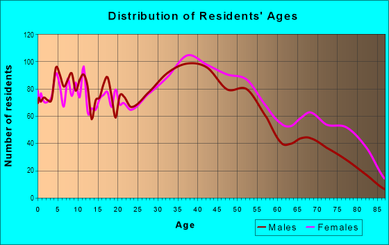
| Males: | 8,902 |
| Females: | 8,451 |
| Males: | 41.5 years |
| Females: | 39.1 years |
Average household size:
| Oakwood Beach: | 19.5 people |
| New York: | 2.5 people |
Percentage of family households:
| Oakwood Beach: | 56.9% |
| New York: | 41.3% |
| Here: | 52.5% |
| New York: | 42.3% |
Percentage of married-couple families with children (among all households):
| Oakwood Beach: | 20.0% |
| New York: | 57.0% |
Percentage of single-mother households (among all households):
| Oakwood Beach: | 11.6% |
| New York: | 9.3% |
Percentage of never married males 15 years old and over:
Percentage of never married females 15 years old and over:
| Oakwood Beach: | 16.1% |
| New York: | 19.8% |
Percentage of never married females 15 years old and over:
| Oakwood Beach: | 15.5% |
| New York: | 18.9% |
Percentage of people that speak English not well or not at all:
| Oakwood Beach: | 16.6% |
| New York: | 6.8% |
Percentage of people born in this state:
Percentage of people born in another U.S. state:
Percentage of native residents but born outside the U.S.:
Percentage of foreign born residents:
| Here: | 57.9% |
| New York: | 62.5% |
Percentage of people born in another U.S. state:
| Oakwood Beach: | 1.6% |
| New York: | 12.2% |
Percentage of native residents but born outside the U.S.:
| Here: | 0.7% |
| New York: | 2.6% |
Percentage of foreign born residents:
| Here: | 39.8% |
| New York: | 22.7% |
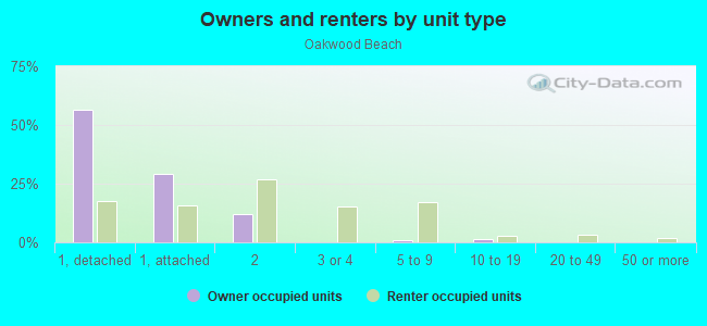
Owner-occupied
Renter-occupied

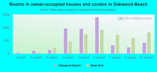
- Rooms in owner-occupied houses and condos in Oakwood Beach
- 421 room
- 1212 rooms
- 1483 rooms
- 9854 rooms
- 9635 rooms
- 1,4056 rooms
- 3367 rooms
- 2538 rooms
- 4229+ rooms
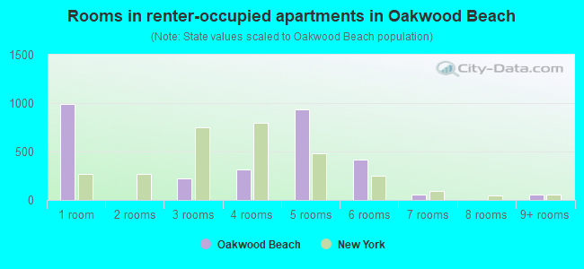
- Rooms in renter-occupied apartments in Oakwood Beach
- 9951 room
- 02 rooms
- 2243 rooms
- 3154 rooms
- 9355 rooms
- 4186 rooms
- 607 rooms
- 08 rooms
- 609+ rooms
Owner-occupied
Renter-occupied
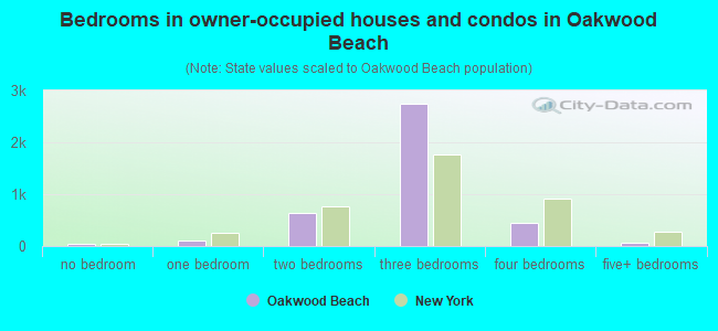
- Bedrooms in owner-occupied houses and condos in Oakwood Beach
- 42no bedroom
- 1011 bedroom
- 6342 bedrooms
- 2,7393 bedrooms
- 4464 bedrooms
- 685+ bedrooms
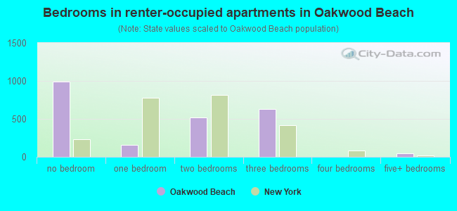
- Bedrooms in renter-occupied apartments in Oakwood Beach
- 995no bedroom
- 1531 bedroom
- 5152 bedrooms
- 6313 bedrooms
- 04 bedrooms
- 505+ bedrooms
Average number of cars or other vehicles available in houses/condos:
Average number of cars or other vehicles available in apartments:
| This neighborhood: | 2.9 |
| New York: | 1.7 |
Average number of cars or other vehicles available in apartments:
| Here: | 2.1 |
| New York: | 0.7 |
Percentage of units with a mortgage:
| Oakwood Beach: | 57.4% |
| New York: | 58.3% |
Housing prices:
- Average estimated value of detached houses in 2022 (51.1% of all units):
Oakwood Beach: $595,637 New York: $476,719
- Average estimated value of townhouses or other attached units in 2022 (28.7% of all units):
This neighborhood: $529,117 New York: $699,270
- Average estimated value of housing units in 2-unit structures in 2022 (20.3% of all units):
This neighborhood: $685,198 New York: $713,077
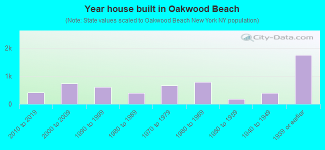
- Year house built in Oakwood Beach
- 02020 or later
- 4052010 to 2019
- 7412000 to 2009
- 6071990 to 1999
- 3881980 to 1989
- 6691970 to 1979
- 7821960 to 1969
- 1731950 to 1959
- 3941940 to 1949
- 1,7511939 or earlier
Travel time to work (commute)
![Travel time to work (commute)]()
- 146Less than 5 minutes
- 2445 to 9 minutes
- 7410 to 14 minutes
- 73515 to 19 minutes
- 1,72020 to 24 minutes
- 72625 to 29 minutes
- 3,09130 to 34 minutes
- 32335 to 39 minutes
- 82540 to 44 minutes
- 1,17445 to 59 minutes
- 3,83260 to 89 minutes
- 1,09590 or more minutes

Means of transportation to work
![Means of transportation to work]()
- 53.0%4,417Drove a car alone
- 4.9%406Carpooled
- 28.9%2,414Bus
- 6.8%571Subway or elevated rail
- 0.7%55Long-distance train or commuter rail
- 1.3%105Ferryboat
- 4.7%390Taxi
- 5.1%424Walked
- 0.8%70Other means
- 9.3%773Worked at home

Time leaving home to go to work
![Time leaving home to go to work]()
- 49112:00 a.m. to 4:59 a.m.
- 6875:00 a.m. to 5:29 a.m.
- 3765:30 a.m. to 5:59 a.m.
- 7566:00 a.m. to 6:29 a.m.
- 1,3326:30 a.m. to 6:59 a.m.
- 2,4307:00 a.m. to 7:29 a.m.
- 1,6917:30 a.m. to 7:59 a.m.
- 1,1878:00 a.m. to 8:29 a.m.
- 1,6978:30 a.m. to 8:59 a.m.
- 4599:00 a.m. to 9:59 a.m.
- 50210:00 a.m. to 10:59 a.m.
- 5711:00 a.m. to 11:59 a.m.
- 2,01812:00 p.m. to 3:59 p.m.
- 1,3124:00 p.m. to 11:59 p.m.

Occupations of males:
- Percentage of males in management occupations (except farmers):
Here: 8.7% New York: 11.9%
- Percentage of males in computer and mathematical occupations:
Here: 5.6% New York: 4.6%
- Percentage of males in education, training, and library occupations:
Here: 1.4% New York: 4.2%
- Percentage of males in service occupations:
Here: 29.4% New York: 16.9%
- Percentage of males in sales and office occupations:
Here: 16.4% New York: 15.2%
- Percentage of males in construction, extraction, and maintenance occupations:
Here: 9.5% New York: 8.2%
- Percentage of males in production occupations:
Here: 7.3% New York: 4.6%
- Percentage of males in transportation occupations:
Here: 6.1% New York: 6.7%
- Percentage of males in material moving occupations:
Here: 4.4% New York: 3.7%
Occupations of females:
- Percentage of females in management occupations (except farmers):
Here: 6.0% New York: 9.8%
- Percentage of females in business and financial operations occupations:
Here: 3.7% New York: 6.5%
- Percentage of females in computer and mathematical occupations:
Here: 3.8% New York: 1.6%
- Percentage of females in life, physical, and social science occupations:
Here: 2.7% New York: 1.1%
- Percentage of females in community and social services occupations:
Here: 4.9% New York: 3.1%
- Percentage of females in legal occupations:
Here: 1.2% New York: 1.9%
- Percentage of females in education, training, and library occupations:
Here: 8.0% New York: 11.3%
- Percentage of females in healthcare practitioners and technical occupations:
Here: 22.7% New York: 9.7%
- Percentage of females in service occupations:
Here: 20.1% New York: 21.4%
- Percentage of females in sales and office occupations:
Here: 24.2% New York: 24.9%
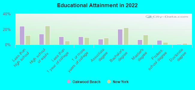
Education in this neighborhood (subdivision or community):
- Percentage of people 3 years and older in K-12 schools:
Oakwood Beach: 18.8% New York: 15.4%
- Percentage of people 3 years and older in undergraduate colleges:
Oakwood Beach: 5.7% New York: 5.3%
- Percentage of people 3 years and older in grad. or professional schools:
Oakwood Beach: 1.2% New York: 1.8%
- Percentage of students K-12 enrolled in private schools:
Oakwood Beach: 25.9% New York: 15.5%
Percentage of population below poverty level:
| Oakwood Beach: | 6.5% |
| New York: | 14.3% |
Median year owner moved in (as recorded in 2022):
Median year renter moved in (as recorded in 2022):
| Oakwood Beach: | 2003 |
| New York: | 2007 |
Median year renter moved in (as recorded in 2022):
| Oakwood Beach: | 2014 |
| New York: | 2018 |
Percentage of married-couple families with both working:
| Oakwood Beach: | 68.5% |
| New York: | 72.1% |
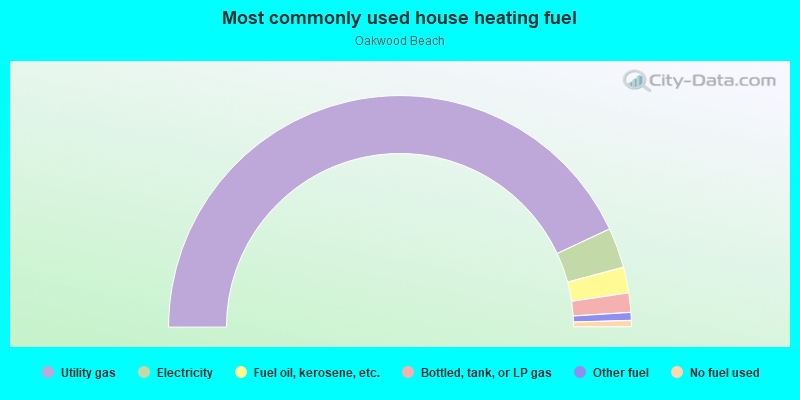
- 86.1%Utility gas
- 5.6%Electricity
- 3.6%Fuel oil, kerosene, etc.
- 2.7%Bottled, tank, or LP gas
- 1.1%Other fuel
- 0.9%No fuel used
Roads and streets:
Mill Rd
Length: 1.36 miles
Directions: E-W, N-S, SW-NE
Address range: 1 to 698
Directions: E-W, N-S, SW-NE
Address range: 1 to 698
New Dorp Ln
Length: 0.85 miles
Direction: SE-NW
Address range: 437 to 699
Direction: SE-NW
Address range: 437 to 699
Milton Ave
Length: 0.81 miles
Direction: SW-NE
Address range: 1 to 399
Direction: SW-NE
Address range: 1 to 399
Roma Ave
Length: 0.79 miles
Direction: SW-NE
Address range: 1 to 320
Direction: SW-NE
Address range: 1 to 320
Finley Ave
Length: 0.78 miles
Directions: SE-NW, SW-NE
Address range: 1 to 351
Directions: SE-NW, SW-NE
Address range: 1 to 351
Falcon Ave
Length: 0.76 miles
Direction: SW-NE
Address range: 419 to 599
Direction: SW-NE
Address range: 419 to 599
Hett Ave
Length: 0.71 miles
Direction: SW-NE
Address range: 1 to 399
Direction: SW-NE
Address range: 1 to 399
Tysens Ln
Length: 0.67 miles
Direction: SE-NW
Address range: 590 to 892
Direction: SE-NW
Address range: 590 to 892
Weed Ave
Length: 0.66 miles
Direction: SW-NE
Address range: 1 to 312
Direction: SW-NE
Address range: 1 to 312
Ebbitts St
Length: 0.65 miles
Direction: SE-NW
Address range: 1 to 217
Direction: SE-NW
Address range: 1 to 217
Titus Ave
Length: 0.59 miles
Direction: SW-NE
Address range: 1 to 279
Direction: SW-NE
Address range: 1 to 279
Cuba Ave
Length: 0.59 miles
Direction: SW-NE
Address range: 1 to 265
Direction: SW-NE
Address range: 1 to 265
Lynn St
Length: 0.58 miles
Direction: SW-NE
Address range: 400 to 580
Direction: SW-NE
Address range: 400 to 580
Cedar Grove Ave
Length: 0.52 miles
Direction: SW-NE
Address range: 1 to 641
Direction: SW-NE
Address range: 1 to 641
Amherst Ave
Length: 0.52 miles
Direction: SW-NE
Address range: 400 to 549
Direction: SW-NE
Address range: 400 to 549
Riga St
Length: 0.50 miles
Direction: SW-NE
Address range: 400 to 639
Direction: SW-NE
Address range: 400 to 639
Fox Ln
Length: 0.50 miles
Direction: SE-NW
Address range: 63 to 249
Direction: SE-NW
Address range: 63 to 249
Isabella Ave
Length: 0.49 miles
Direction: SE-NW
Address range: 309 to 462
Direction: SE-NW
Address range: 309 to 462
Foxbeach Ave
Length: 0.48 miles
Direction: SE-NW
Address range: 27 to 199
Direction: SE-NW
Address range: 27 to 199
Fairbanks Ave
Length: 0.47 miles
Direction: SE-NW
Address range: 305 to 504
Direction: SE-NW
Address range: 305 to 504
Promenade Ave
Length: 0.47 miles
Direction: SE-NW
Address range: 1 to 499
Direction: SE-NW
Address range: 1 to 499
Tarlton St
Length: 0.46 miles
Direction: SE-NW
Address range: 1 to 123
Direction: SE-NW
Address range: 1 to 123
Manila Ave
Length: 0.45 miles
Direction: SW-NE
Address range: 75 to 180
Direction: SW-NE
Address range: 75 to 180
Kissam Ave
Length: 0.44 miles
Direction: SE-NW
Address range: 1 to 157
Direction: SE-NW
Address range: 1 to 157
Brook Ave
Length: 0.42 miles
Directions: N-S, SE-NW, SW-NE
Address range: 24 to 168
Directions: N-S, SE-NW, SW-NE
Address range: 24 to 168
Winham Ave
Length: 0.41 miles
Direction: SW-NE
Address range: 1 to 199
Direction: SW-NE
Address range: 1 to 199
Aviston St
Length: 0.39 miles
Direction: SE-NW
Address range: 1 to 169
Direction: SE-NW
Address range: 1 to 169
Pelican Cir
Length: 0.38 miles
Directions: N-S, SE-NW, SW-NE
Address range: 18 to 140
Directions: N-S, SE-NW, SW-NE
Address range: 18 to 140
Guyon Ave
Length: 0.38 miles
Direction: SE-NW
Address range: 306 to 434
Direction: SE-NW
Address range: 306 to 434
Tarrytown Ave
Length: 0.37 miles
Direction: SW-NE
Address range: 400 to 599
Direction: SW-NE
Address range: 400 to 599
Oak Ave
Length: 0.35 miles
Directions: E-W, SE-NW
Address range: 375 to 548
Directions: E-W, SE-NW
Address range: 375 to 548
Adelaide Ave
Length: 0.35 miles
Directions: E-W, SE-NW
Address range: 300 to 499
Directions: E-W, SE-NW
Address range: 300 to 499
Marine Way
Length: 0.34 miles
Direction: SE-NW
Address range: 29 to 175
Direction: SE-NW
Address range: 29 to 175
Medina St
Length: 0.32 miles
Direction: SW-NE
Address range: 400 to 529
Direction: SW-NE
Address range: 400 to 529
Cedar Grove Ave Exd
Length: 0.30 miles
Direction: SW-NE
Direction: SW-NE
Isernia Ave
Length: 0.29 miles
Directions: E-W, SE-NW
Address range: 1 to 271
Directions: E-W, SE-NW
Address range: 1 to 271
Dugdale St
Length: 0.28 miles
Direction: SE-NW
Address range: 1 to 164
Direction: SE-NW
Address range: 1 to 164
Pendale St
Length: 0.23 miles
Direction: SW-NE
Address range: 560 to 581
Direction: SW-NE
Address range: 560 to 581
Eva Ave
Length: 0.20 miles
Direction: SE-NW
Address range: 1 to 99
Direction: SE-NW
Address range: 1 to 99
Dustan St
Length: 0.20 miles
Direction: SW-NE
Address range: 1 to 99
Direction: SW-NE
Address range: 1 to 99
Grayson St
Length: 0.20 miles
Direction: SW-NE
Address range: 1 to 98
Direction: SW-NE
Address range: 1 to 98
Roberts Dr
Length: 0.20 miles
Direction: SE-NW
Address range: 1 to 79
Direction: SE-NW
Address range: 1 to 79
Garibaldi Ave
Length: 0.18 miles
Direction: SE-NW
Address range: 1 to 76
Direction: SE-NW
Address range: 1 to 76
Peter Ave
Length: 0.18 miles
Direction: SE-NW
Address range: 316 to 398
Direction: SE-NW
Address range: 316 to 398
Beacon Pl
Length: 0.18 miles
Direction: SE-NW
Address range: 1 to 75
Direction: SE-NW
Address range: 1 to 75
Penn Ave
Length: 0.18 miles
Direction: SE-NW
Address range: 301 to 382
Direction: SE-NW
Address range: 301 to 382
Waterside St
Length: 0.16 miles
Direction: SE-NW
Address range: 1 to 60
Direction: SE-NW
Address range: 1 to 60
Navesink Pl
Length: 0.16 miles
Direction: SE-NW
Address range: 1 to 99
Direction: SE-NW
Address range: 1 to 99
Wavecrest St
Length: 0.16 miles
Direction: SE-NW
Address range: 1 to 68
Direction: SE-NW
Address range: 1 to 68
Neptune St
Length: 0.16 miles
Direction: SE-NW
Address range: 1 to 66
Direction: SE-NW
Address range: 1 to 66
Seafoam St
Length: 0.16 miles
Direction: SE-NW
Address range: 1 to 73
Direction: SE-NW
Address range: 1 to 73
Herman St (Maple Ter)
Length: 0.16 miles
Direction: SE-NW
Address range: 1 to 99
Direction: SE-NW
Address range: 1 to 99
Milbank Rd
Length: 0.16 miles
Direction: SE-NW
Address range: 1 to 72
Direction: SE-NW
Address range: 1 to 72
Center Pl
Length: 0.16 miles
Direction: SE-NW
Address range: 1 to 66
Direction: SE-NW
Address range: 1 to 66
Topping St
Length: 0.16 miles
Direction: SE-NW
Address range: 1 to 69
Direction: SE-NW
Address range: 1 to 69
Stoneham St
Length: 0.15 miles
Direction: SW-NE
Address range: 400 to 500
Direction: SW-NE
Address range: 400 to 500
Chesterton Ave
Length: 0.15 miles
Direction: SE-NW
Address range: 300 to 379
Direction: SE-NW
Address range: 300 to 379
Delwit Ave
Length: 0.14 miles
Direction: SW-NE
Address range: 15 to 58
Direction: SW-NE
Address range: 15 to 58
Cedar Grove Ct
Length: 0.14 miles
Direction: SE-NW
Address range: 1 to 199
Direction: SE-NW
Address range: 1 to 199
Ina St
Length: 0.13 miles
Direction: SE-NW
Address range: 1 to 52
Direction: SE-NW
Address range: 1 to 52
Clayboard St
Length: 0.12 miles
Direction: SE-NW
Address range: 1 to 49
Direction: SE-NW
Address range: 1 to 49
Celtic Pl
Length: 0.12 miles
Direction: SE-NW
Address range: 2 to 22
Direction: SE-NW
Address range: 2 to 22
Montreal Ave
Length: 0.12 miles
Direction: SE-NW
Address range: 390 to 449
Direction: SE-NW
Address range: 390 to 449
Manila Pl
Length: 0.11 miles
Direction: SW-NE
Address range: 1 to 76
Direction: SW-NE
Address range: 1 to 76
Primrose Pl
Length: 0.11 miles
Direction: SW-NE
Address range: 1 to 47
Direction: SW-NE
Address range: 1 to 47
Malone Ave
Length: 0.10 miles
Direction: SE-NW
Address range: 191 to 239
Direction: SE-NW
Address range: 191 to 239
Hylan Blvd
Length: 0.09 miles
Direction: E-W
Address range: 3069 to 3108
Direction: E-W
Address range: 3069 to 3108
Merkel Pl
Length: 0.08 miles
Direction: SW-NE
Address range: 1 to 599
Direction: SW-NE
Address range: 1 to 599
Michelle Ln
Length: 0.07 miles
Directions: SE-NW, SW-NE
Address range: 1 to 46
Directions: SE-NW, SW-NE
Address range: 1 to 46
Diaz Pl
Length: 0.07 miles
Direction: SE-NW
Address range: 1 to 100
Direction: SE-NW
Address range: 1 to 100
Malden Pl
Length: 0.07 miles
Direction: SE-NW
Address range: 280 to 301
Direction: SE-NW
Address range: 280 to 301
Barry Ct
Length: 0.06 miles
Directions: N-S, SE-NW
Address range: 1 to 99
Directions: N-S, SE-NW
Address range: 1 to 99
8 St (8th St)
Length: 0.06 miles
Direction: SW-NE
Direction: SW-NE
Mill Ln
Length: 0.03 miles
Direction: SW-NE
Address range: 1 to 99
Direction: SW-NE
Address range: 1 to 99
Windmill Ct
Length: 0.03 miles
Direction: SE-NW
Address range: 1 to 99
Direction: SE-NW
Address range: 1 to 99
Foss Ave
Length: 0.03 miles
Direction: SW-NE
Address range: 1 to 99
Direction: SW-NE
Address range: 1 to 99
Jennifer Ln
Length: 0.03 miles
Direction: SE-NW
Direction: SE-NW
Boehm Pl
Length: 0.01 miles
Direction: E-W
Direction: E-W