Loudonville (Loudinville) neighborhood in Loudonville, Ohio (OH), 44842, 44864 detailed profile
Settings
X


Business Search - 14 Million verified businesses
Area: 22.982 square miles
Population: 2,600
Population density:
| Loudonville (Loudinville): | 113 people per square mile |
| Loudonville: | 1,166 people per square mile |

- 2,39781.6%White
- 35212.0%Hispanic or Latino
- 1043.5%Two or more races
- 401.4%Asian
- 220.7%American Indian
- 150.5%Black
- 50.2%Some other race
- 20.07%Native Hawaiian and Other
Pacific Islander

Median household income in 2022:
| Loudonville (Loudinville): | $67,337 |
| Loudonville: | $51,557 |
Distribution of median household income
![Distribution of median household income]()
- 44Less than $10,000
- 54$10,000 to $19,999
- 169$20,000 to $29,999
- 230$30,000 to $39,999
- 118$40,000 to $49,999
- 101$50,000 to $59,999
- 85$60,000 to $74,999
- 155$75,000 to $99,999
- 119$100,000 to $124,999
- 48$125,000 to $149,999
- 30$150,000 to $199,999
- 35$200,000 or more

Distribution of owner-occupied house/condo value
![Distribution of owner-occupied house/condo value]()
- 228Less than $50,000
- 313$50,000 to $99,999
- 241$100,000 to $149,999
- 122$150,000 to $199,999
- 122$200,000 to $249,999
- 50$250,000 to $299,999
- 52$300,000 to $399,999
- 13$400,000 to $499,999
- 26$500,000 to $749,999
- 15$750,000 to $999,999
- 17$1,000,000 or more

Distribution of rent paid by renters
![Distribution of rent paid by renters]()
- 29Less than $100
- 58$100 to $199
- 1,831$200 to $299
- 109$300 to $399
- 145$400 to $499
- 98$500 to $599
- 284$600 to $699
- 46$700 to $799
- 29$800 to $899
- 32$900 to $999
- 11$1,000 to $1,249
- 202$2,000 or more

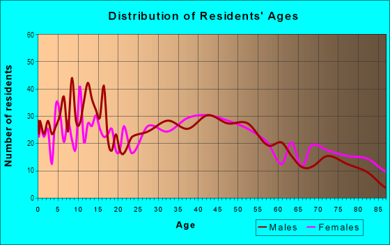
| Males: | 1,380 |
| Females: | 1,219 |
Males:
| This neighborhood: | 41.6 years |
| Whole city: | 33.9 years |
| This neighborhood: | 48.0 years |
| Whole city: | 48.7 years |
Average household size:
| Loudonville (Loudinville): | 2.5 people |
| Loudonville: | 2.5 people |
Percentage of family households:
| Loudonville (Loudinville): | 42.9% |
| Loudonville: | 39.5% |
| Here: | 49.0% |
| Loudonville: | 42.5% |
Percentage of married-couple families with children (among all households):
| Loudonville (Loudinville): | 26.8% |
| Loudonville: | 22.9% |
Percentage of single-mother households (among all households):
| Loudonville (Loudinville): | 13.3% |
| Loudonville: | 12.6% |
Percentage of never married males 15 years old and over:
Percentage of never married females 15 years old and over:
| Loudonville (Loudinville): | 16.9% |
| Loudonville: | 17.0% |
Percentage of never married females 15 years old and over:
| Loudonville (Loudinville): | 13.4% |
| village: | 16.1% |
Percentage of people that speak English not well or not at all:
| Loudonville (Loudinville): | 0.0% |
| Loudonville: | 0.0% |
Percentage of people born in this state:
Percentage of people born in another U.S. state:
Percentage of native residents but born outside the U.S.:
Percentage of foreign born residents:
| Here: | 84.1% |
| Loudonville: | 84.9% |
Percentage of people born in another U.S. state:
| Loudonville (Loudinville): | 15.0% |
| Loudonville: | 14.3% |
Percentage of native residents but born outside the U.S.:
| Here: | 0.7% |
| village: | 0.2% |
Percentage of foreign born residents:
| Here: | 0.5% |
| Loudonville: | 0.7% |

Owner-occupied
Renter-occupied


- Rooms in owner-occupied houses and condos in Loudonville <
> - 381 room
- 82 rooms
- 233 rooms
- 524 rooms
- 1175 rooms
- 1586 rooms
- 917 rooms
- 988 rooms
- 1639+ rooms

- Rooms in renter-occupied apartments in Loudonville <
> - 1841 room
- 112 rooms
- 1053 rooms
- 774 rooms
- 1195 rooms
- 536 rooms
- 1207 rooms
- 388 rooms
- 209+ rooms
Owner-occupied
Renter-occupied

- Bedrooms in owner-occupied houses and condos in Loudonville <
> - 38no bedroom
- 181 bedroom
- 1252 bedrooms
- 4013 bedrooms
- 924 bedrooms
- 875+ bedrooms

- Bedrooms in renter-occupied apartments in Loudonville <
> - 184no bedroom
- 681 bedroom
- 1032 bedrooms
- 853 bedrooms
- 1064 bedrooms
- 45+ bedrooms
Average number of cars or other vehicles available in houses/condos:
Average number of cars or other vehicles available in apartments:
| This neighborhood: | 2.3 |
| Loudonville: | 2.1 |
Average number of cars or other vehicles available in apartments:
| Here: | 1.4 |
| village: | 1.2 |
Percentage of units with a mortgage:
| Loudonville (Loudinville): | 55.0% |
| Loudonville: | 56.8% |
Housing prices:
- Average estimated value of detached houses in 2022 (77.9% of all units):
Loudonville (Loudinville): $214,887 Ohio: $254,366
- Average estimated value of mobile home in 2022 (6.0% of all units):
Loudonville (Loudinville): $36,565 Ohio: $62,719

- Year house built in Loudonville <
> - 42020 or later
- 222010 to 2019
- 1442000 to 2009
- 1401990 to 1999
- 481980 to 1989
- 1271970 to 1979
- 1491960 to 1969
- 1601950 to 1959
- 1301940 to 1949
- 3301939 or earlier

City-data.com crime index for village in 2020 (higher means more crime):
| City: | 104.8 |
| U.S. average: | 219.5 |
Travel time to work (commute)
![Travel time to work (commute)]()
- 90Less than 5 minutes
- 2065 to 9 minutes
- 9710 to 14 minutes
- 16015 to 19 minutes
- 14220 to 24 minutes
- 15125 to 29 minutes
- 15830 to 34 minutes
- 3835 to 39 minutes
- 2440 to 44 minutes
- 6645 to 59 minutes
- 4160 to 89 minutes
- 2090 or more minutes

Means of transportation to work
![Means of transportation to work]()
- 70.8%828Drove a car alone
- 19.2%225Carpooled
- 0.5%6Bus
- 0.5%6Subway or elevated rail
- 3.7%43Taxi
- 4.8%56Motorcycle
- 0.1%1Bicycle
- 9.8%115Walked
- 3.8%45Other means
- 4.3%50Worked at home

Time leaving home to go to work
![Time leaving home to go to work]()
- 5412:00 a.m. to 4:59 a.m.
- 885:00 a.m. to 5:29 a.m.
- 1515:30 a.m. to 5:59 a.m.
- 1306:00 a.m. to 6:29 a.m.
- 1256:30 a.m. to 6:59 a.m.
- 1247:00 a.m. to 7:29 a.m.
- 1317:30 a.m. to 7:59 a.m.
- 1028:00 a.m. to 8:29 a.m.
- 608:30 a.m. to 8:59 a.m.
- 369:00 a.m. to 9:59 a.m.
- 2510:00 a.m. to 10:59 a.m.
- 711:00 a.m. to 11:59 a.m.
- 14012:00 p.m. to 3:59 p.m.
- 494:00 p.m. to 11:59 p.m.

Occupations of males:
- Percentage of males in management occupations (except farmers):
Here: 5.8% village: 7.2%
- Percentage of males in business and financial operations occupations:
Here: 4.7% village: 2.3%
- Percentage of males in architecture and engineering occupations:
Here: 1.9% village: 1.7%
- Percentage of males in service occupations:
Here: 12.8% village: 10.7%
- Percentage of males in sales and office occupations:
Here: 18.7% village: 21.8%
- Percentage of males in farming, fishing, and forestry occupations:
Here: 1.3% village: 0.0%
- Percentage of males in construction, extraction, and maintenance occupations:
Here: 9.7% village: 6.3%
- Percentage of males in production occupations:
Here: 18.6% village: 18.1%
- Percentage of males in transportation occupations:
Here: 4.5% village: 5.6%
- Percentage of males in material moving occupations:
Here: 10.5% village: 12.2%
Occupations of females:
- Percentage of females in management occupations (except farmers):
Here: 3.2% village: 4.0%
- Percentage of females in business and financial operations occupations:
Here: 1.0% village: 0.6%
- Percentage of females in computer and mathematical occupations:
Here: 1.7% village: 0.0%
- Percentage of females in architecture and engineering occupations:
Here: 2.8% village: 2.6%
- Percentage of females in community and social services occupations:
Here: 1.2% village: 1.1%
- Percentage of females in education, training, and library occupations:
Here: 8.2% village: 5.9%
- Percentage of females in healthcare practitioners and technical occupations:
Here: 5.6% village: 5.5%
- Percentage of females in service occupations:
Here: 29.6% village: 33.9%
- Percentage of females in sales and office occupations:
Here: 21.4% village: 24.2%
- Percentage of females in production occupations:
Here: 13.0% village: 8.2%
- Percentage of females in material moving occupations:
Here: 9.3% village: 10.2%
Education in this neighborhood (subdivision or community):
- Percentage of people 3 years and older in K-12 schools:
Loudonville (Loudinville): 26.2% Loudonville: 18.9%
- Percentage of people 3 years and older in undergraduate colleges:
Loudonville (Loudinville): 3.4% Loudonville: 2.6%
- Percentage of people 3 years and older in grad. or professional schools:
Loudonville (Loudinville): 1.6% Loudonville: 0.6%
- Percentage of students K-12 enrolled in private schools:
Loudonville (Loudinville): 19.4% Loudonville: 2.3%
Percentage of population below poverty level:
| Loudonville (Loudinville): | 11.2% |
| Loudonville: | 15.4% |
Median year owner moved in (as recorded in 2022):
| Loudonville (Loudinville): | 2003 |
| Loudonville: | 2005 |
Percentage of married-couple families with both working:
| Loudonville (Loudinville): | 75.6% |
| Loudonville: | 49.3% |

- 43.6%Utility gas
- 20.9%Bottled, tank, or LP gas
- 18.6%Electricity
- 9.5%Wood
- 3.2%Other fuel
- 2.8%Fuel oil, kerosene, etc.
- 1.1%No fuel used
Limited-access highways (interstate or state) in this neighborhood:
Hagan Dr
Length: 0.06 miles
Direction: N-S
Direction: N-S
Highways in this neighborhood:
State Rte 3
Length: 2.25 miles
Directions: N-S, SW-NE
Address range: 3002 to 3183
Directions: N-S, SW-NE
Address range: 3002 to 3183
State Rte 60
Length: 1.96 miles
Directions: N-S, SE-NW, SW-NE
Address range: 2684 to 2899
Directions: N-S, SE-NW, SW-NE
Address range: 2684 to 2899
State Rte 39
Length: 1.65 miles
Directions: E-W, SE-NW
Address range: 608 to 727
Directions: E-W, SE-NW
Address range: 608 to 727
State Rte 97
Length: 0.97 miles
Directions: E-W, N-S, SW-NE
Address range: 781 to 830
Directions: E-W, N-S, SW-NE
Address range: 781 to 830
E Main St (State Rte 39, State Rte 60)
Length: 0.88 miles
Direction: E-W
Address range: 101 to 1151
Direction: E-W
Address range: 101 to 1151
State Rte 39 (N Mount Vernon Ave)
Length: 0.76 miles
Directions: N-S, SE-NW
Address range: 100 to 901
Directions: N-S, SE-NW
Address range: 100 to 901
State Rte 3 (N Union St, State Rte 60)
Length: 0.70 miles
Direction: N-S
Address range: 100 to 999
Direction: N-S
Address range: 100 to 999
State Rte 3 (S Market St)
Length: 0.62 miles
Directions: N-S, SW-NE
Address range: 100 to 999
Directions: N-S, SW-NE
Address range: 100 to 999
State Rte 3 (Wooster Rd)
Length: 0.48 miles
Directions: E-W, SW-NE
Address range: 500 to 1199
Directions: E-W, SW-NE
Address range: 500 to 1199
Roads and streets:
Co Hwy 3175
Length: 3.44 miles
Directions: E-W, N-S, SE-NW, SW-NE
Address range: 3039 to 3299
Directions: E-W, N-S, SE-NW, SW-NE
Address range: 3039 to 3299
Co Rd 529
Length: 2.37 miles
Directions: E-W, N-S, SE-NW
Address range: 800 to 3199
Directions: E-W, N-S, SE-NW
Address range: 800 to 3199
Twp Rd 3075
Length: 1.93 miles
Directions: E-W, N-S, SE-NW
Address range: 500 to 697
Directions: E-W, N-S, SE-NW
Address range: 500 to 697
Co Rd 3a (S Mount Vernon Ave)
Length: 1.42 miles
Directions: N-S, SW-NE
Address range: 100 to 3099
Directions: N-S, SW-NE
Address range: 100 to 3099
Co Hwy 2920
Length: 1.34 miles
Direction: E-W
Address range: 600 to 791
Direction: E-W
Address range: 600 to 791
Twp Hwy 2724
Length: 1.33 miles
Directions: E-W, N-S, SW-NE
Address range: 572 to 697
Directions: E-W, N-S, SW-NE
Address range: 572 to 697
Co Rd 775
Length: 1.30 miles
Directions: E-W, SE-NW
Address range: 2782 to 2866
Directions: E-W, SE-NW
Address range: 2782 to 2866
Mill Rd (Co Hwy 775)
Length: 1.24 miles
Directions: N-S, SE-NW
Address range: 706 to 2899
Directions: N-S, SE-NW
Address range: 706 to 2899
Co Rd 687
Length: 1.21 miles
Directions: E-W, N-S, SE-NW
Address range: 2669 to 8050
Directions: E-W, N-S, SE-NW
Address range: 2669 to 8050
Twp Hwy 2850 (Twp Rd 2850)
Length: 1.18 miles
Directions: E-W, N-S, SE-NW
Address range: 600 to 699
Directions: E-W, N-S, SE-NW
Address range: 600 to 699
W Main St
Length: 1.12 miles
Direction: E-W
Address range: 100 to 899
Direction: E-W
Address range: 100 to 899
Twp Rd 3132
Length: 1.07 miles
Directions: E-W, N-S, SW-NE
Directions: E-W, N-S, SW-NE
Park Pl
Length: 1.05 miles
Directions: E-W, N-S, SE-NW
Address range: 100 to 599
Directions: E-W, N-S, SE-NW
Address range: 100 to 599
Co Hwy 3175 (Wally Rd)
Length: 1.01 miles
Directions: E-W, N-S, SE-NW, SW-NE
Address range: 132 to 3033
Directions: E-W, N-S, SE-NW, SW-NE
Address range: 132 to 3033
Twp Hwy 2744
Length: 0.93 miles
Directions: E-W, SW-NE
Address range: 700 to 799
Directions: E-W, SW-NE
Address range: 700 to 799
Twp Rd 3050
Length: 0.70 miles
Directions: E-W, SE-NW
Address range: 500 to 599
Directions: E-W, SE-NW
Address range: 500 to 599
N Spring St
Length: 0.69 miles
Directions: E-W, N-S, SE-NW
Address range: 100 to 899
Directions: E-W, N-S, SE-NW
Address range: 100 to 899
E Campbell St
Length: 0.67 miles
Directions: E-W, N-S, SW-NE
Address range: 100 to 799
Directions: E-W, N-S, SW-NE
Address range: 100 to 799
E Washington St
Length: 0.63 miles
Direction: E-W
Address range: 100 to 699
Direction: E-W
Address range: 100 to 699
N Market St
Length: 0.63 miles
Direction: N-S
Address range: 100 to 799
Direction: N-S
Address range: 100 to 799
Fuller Rd (Twp Hwy 3044)
Length: 0.60 miles
Directions: E-W, SW-NE
Address range: 664 to 799
Directions: E-W, SW-NE
Address range: 664 to 799
Twp Hwy 2802 (Twp Rd 2802)
Length: 0.60 miles
Directions: E-W, N-S, SW-NE
Address range: 502 to 535
Directions: E-W, N-S, SW-NE
Address range: 502 to 535
Twp Rd 709
Length: 0.59 miles
Direction: N-S
Address range: 2900 to 2998
Direction: N-S
Address range: 2900 to 2998
Campus Dr
Length: 0.57 miles
Directions: E-W, N-S, SE-NW, SW-NE
Directions: E-W, N-S, SE-NW, SW-NE
Twp Hwy 759
Length: 0.55 miles
Directions: E-W, N-S, SE-NW
Address range: 2900 to 2999
Directions: E-W, N-S, SE-NW
Address range: 2900 to 2999
N Water St
Length: 0.55 miles
Directions: N-S, SE-NW, SW-NE
Address range: 100 to 799
Directions: N-S, SE-NW, SW-NE
Address range: 100 to 799
Loudon Ave
Length: 0.51 miles
Directions: E-W, SW-NE
Address range: 101 to 398
Directions: E-W, SW-NE
Address range: 101 to 398
E Haskell St
Length: 0.43 miles
Direction: E-W
Address range: 154 to 499
Direction: E-W
Address range: 154 to 499
E Pendleton St
Length: 0.43 miles
Directions: E-W, SW-NE
Address range: 100 to 499
Directions: E-W, SW-NE
Address range: 100 to 499
E Bustle St
Length: 0.43 miles
Direction: E-W
Address range: 100 to 440
Direction: E-W
Address range: 100 to 440
Co Rd 457
Length: 0.43 miles
Direction: N-S
Address range: 2646 to 2699
Direction: N-S
Address range: 2646 to 2699
Tannehill Rd (Twp Rd 2850)
Length: 0.42 miles
Direction: E-W
Address range: 701 to 999
Direction: E-W
Address range: 701 to 999
W Campbell St
Length: 0.42 miles
Directions: E-W, N-S, SE-NW, SW-NE
Address range: 100 to 499
Directions: E-W, N-S, SE-NW, SW-NE
Address range: 100 to 499
Twp Rd 659 (N View Dr, Northview Hgts Rd)
Length: 0.41 miles
Directions: E-W, N-S, SE-NW
Address range: 100 to 2999
Directions: E-W, N-S, SE-NW
Address range: 100 to 2999
Brentwood Dr
Length: 0.39 miles
Directions: N-S, SE-NW
Address range: 100 to 299
Directions: N-S, SE-NW
Address range: 100 to 299
S Water St
Length: 0.39 miles
Directions: N-S, SE-NW
Address range: 100 to 527
Directions: N-S, SE-NW
Address range: 100 to 527
N Adams St
Length: 0.35 miles
Directions: E-W, N-S, SE-NW
Address range: 100 to 499
Directions: E-W, N-S, SE-NW
Address range: 100 to 499
N Jefferson St
Length: 0.35 miles
Direction: N-S
Address range: 100 to 499
Direction: N-S
Address range: 100 to 499
N Wood St
Length: 0.34 miles
Direction: N-S
Address range: 101 to 444
Direction: N-S
Address range: 101 to 444
Riverside Dr
Length: 0.33 miles
Direction: N-S
Address range: 100 to 521
Direction: N-S
Address range: 100 to 521
Washington St
Length: 0.33 miles
Direction: E-W
Address range: 100 to 399
Direction: E-W
Address range: 100 to 399
Huffman Rd
Length: 0.33 miles
Directions: N-S, SE-NW
Address range: 100 to 445
Directions: N-S, SE-NW
Address range: 100 to 445
Birch Dr
Length: 0.32 miles
Directions: E-W, N-S, SE-NW, SW-NE
Address range: 101 to 726
Directions: E-W, N-S, SE-NW, SW-NE
Address range: 101 to 726
Pine Ave
Length: 0.30 miles
Direction: N-S
Address range: 100 to 179
Direction: N-S
Address range: 100 to 179
E Butler St
Length: 0.30 miles
Direction: E-W
Address range: 100 to 299
Direction: E-W
Address range: 100 to 299
N Pleasant Dr
Length: 0.29 miles
Directions: N-S, SW-NE
Address range: 100 to 399
Directions: N-S, SW-NE
Address range: 100 to 399
Middle Dr
Length: 0.29 miles
Direction: E-W
Address range: 100 to 799
Direction: E-W
Address range: 100 to 799
Kathryn Dr
Length: 0.28 miles
Direction: E-W
Address range: 722 to 816
Direction: E-W
Address range: 722 to 816
Snyder Dr
Length: 0.28 miles
Direction: N-S
Address range: 500 to 607
Direction: N-S
Address range: 500 to 607
S Jefferson St
Length: 0.27 miles
Directions: N-S, SE-NW
Address range: 100 to 299
Directions: N-S, SE-NW
Address range: 100 to 299
Jackson St
Length: 0.27 miles
Direction: E-W
Address range: 198 to 422
Direction: E-W
Address range: 198 to 422
S Wood St
Length: 0.25 miles
Direction: N-S
Address range: 112 to 341
Direction: N-S
Address range: 112 to 341
S Pleasant Dr
Length: 0.25 miles
Direction: N-S
Address range: 100 to 199
Direction: N-S
Address range: 100 to 199
Youngs Ter
Length: 0.24 miles
Directions: E-W, N-S, SE-NW
Address range: 303 to 603
Directions: E-W, N-S, SE-NW
Address range: 303 to 603
Vincent Dr
Length: 0.23 miles
Direction: N-S
Address range: 500 to 899
Direction: N-S
Address range: 500 to 899
W North Park Pl
Length: 0.23 miles
Directions: E-W, SE-NW
Address range: 100 to 119
Directions: E-W, SE-NW
Address range: 100 to 119
Butler St
Length: 0.23 miles
Direction: E-W
Address range: 100 to 299
Direction: E-W
Address range: 100 to 299
Humm Ave
Length: 0.22 miles
Direction: E-W
Direction: E-W
W Bustle St
Length: 0.22 miles
Directions: E-W, SE-NW
Address range: 100 to 299
Directions: E-W, SE-NW
Address range: 100 to 299
Lincoln Ct
Length: 0.22 miles
Direction: E-W
Direction: E-W
Valley View Dr
Length: 0.22 miles
Directions: N-S, SE-NW
Address range: 800 to 899
Directions: N-S, SE-NW
Address range: 800 to 899
Tanya Ter
Length: 0.22 miles
Directions: E-W, N-S, SE-NW, SW-NE
Address range: 467 to 999
Directions: E-W, N-S, SE-NW, SW-NE
Address range: 467 to 999
Twp Hwy 2812
Length: 0.21 miles
Directions: E-W, N-S, SE-NW
Address range: 2800 to 2832
Directions: E-W, N-S, SE-NW
Address range: 2800 to 2832
S Park Pl
Length: 0.19 miles
Direction: E-W
Address range: 522 to 576
Direction: E-W
Address range: 522 to 576
Rose Ct
Length: 0.18 miles
Directions: E-W, N-S, SE-NW
Address range: 400 to 422
Directions: E-W, N-S, SE-NW
Address range: 400 to 422
Walnut Ct
Length: 0.18 miles
Directions: E-W, N-S, SE-NW
Address range: 100 to 299
Directions: E-W, N-S, SE-NW
Address range: 100 to 299
Perry Ave
Length: 0.18 miles
Directions: E-W, N-S, SE-NW, SW-NE
Directions: E-W, N-S, SE-NW, SW-NE
Koch Dr E
Length: 0.17 miles
Directions: E-W, N-S, SW-NE
Directions: E-W, N-S, SW-NE
N Brentwood Dr
Length: 0.17 miles
Direction: N-S
Direction: N-S
Market St
Length: 0.17 miles
Direction: E-W
Direction: E-W
Pendleton St
Length: 0.17 miles
Direction: E-W
Address range: 100 to 317
Direction: E-W
Address range: 100 to 317
S Adams St
Length: 0.17 miles
Direction: N-S
Address range: 100 to 299
Direction: N-S
Address range: 100 to 299
E Burwell Ave
Length: 0.16 miles
Direction: E-W
Address range: 100 to 299
Direction: E-W
Address range: 100 to 299
W Burwell Ave
Length: 0.16 miles
Direction: E-W
Direction: E-W
Pennell Dr
Length: 0.15 miles
Direction: SE-NW
Address range: 700 to 920
Direction: SE-NW
Address range: 700 to 920
Twp Hwy 809
Length: 0.13 miles
Direction: N-S
Direction: N-S
Pearl Dr
Length: 0.12 miles
Directions: E-W, N-S, SE-NW
Address range: 700 to 1399
Directions: E-W, N-S, SE-NW
Address range: 700 to 1399
Hoyer Ct
Length: 0.12 miles
Direction: E-W
Address range: 301 to 407
Direction: E-W
Address range: 301 to 407
Baker Ct
Length: 0.12 miles
Direction: E-W
Address range: 301 to 335
Direction: E-W
Address range: 301 to 335
Highland Ct
Length: 0.11 miles
Direction: E-W
Address range: 301 to 327
Direction: E-W
Address range: 301 to 327
Overlook Dr
Length: 0.11 miles
Directions: N-S, SW-NE
Directions: N-S, SW-NE
Haskell St
Length: 0.11 miles
Direction: E-W
Direction: E-W
Iowa Dr
Length: 0.11 miles
Direction: E-W
Direction: E-W
Wally Brg
Length: 0.10 miles
Directions: N-S, SE-NW, SW-NE
Directions: N-S, SE-NW, SW-NE
Stone Meadow Cir
Length: 0.09 miles
Direction: E-W
Address range: 100 to 266
Direction: E-W
Address range: 100 to 266
Parson Ct
Length: 0.09 miles
Direction: N-S
Direction: N-S
S Union St
Length: 0.09 miles
Direction: N-S
Direction: N-S
S Spring St
Length: 0.09 miles
Directions: N-S, SE-NW
Address range: 100 to 199
Directions: N-S, SE-NW
Address range: 100 to 199
S Pine Ave
Length: 0.08 miles
Direction: N-S
Address range: 200 to 299
Direction: N-S
Address range: 200 to 299
Monroe St
Length: 0.08 miles
Direction: N-S
Address range: 200 to 314
Direction: N-S
Address range: 200 to 314
Bustle St
Length: 0.08 miles
Direction: E-W
Direction: E-W
Wales Dr
Length: 0.08 miles
Direction: N-S
Address range: 300 to 634
Direction: N-S
Address range: 300 to 634
Elma Ave
Length: 0.07 miles
Direction: N-S
Direction: N-S
Oak Dr
Length: 0.07 miles
Directions: N-S, SW-NE
Directions: N-S, SW-NE
T R 709
Length: 0.07 miles
Direction: N-S
Direction: N-S
Oak Ct
Length: 0.07 miles
Direction: N-S
Address range: 300 to 330
Direction: N-S
Address range: 300 to 330
Kettering Dr
Length: 0.07 miles
Direction: N-S
Direction: N-S
Smith Ave
Length: 0.06 miles
Direction: E-W
Direction: E-W
Campus Ave
Length: 0.06 miles
Direction: E-W
Address range: 401 to 421
Direction: E-W
Address range: 401 to 421
Hale Ave
Length: 0.06 miles
Direction: E-W
Direction: E-W
E North Park Pl
Length: 0.05 miles
Direction: E-W
Address range: 100 to 131
Direction: E-W
Address range: 100 to 131
E North St
Length: 0.05 miles
Directions: E-W, SW-NE
Directions: E-W, SW-NE
Twp Rd 749
Length: 0.05 miles
Direction: N-S
Address range: 2902 to 2921
Direction: N-S
Address range: 2902 to 2921
Welch Rd
Length: 0.04 miles
Direction: SE-NW
Direction: SE-NW
Phillips Ct
Length: 0.04 miles
Directions: E-W, SE-NW
Address range: 100 to 199
Directions: E-W, SE-NW
Address range: 100 to 199
West St
Length: 0.03 miles
Direction: N-S
Address range: 400 to 499
Direction: N-S
Address range: 400 to 499
Cherry
Length: 0.03 miles
Direction: N-S
Direction: N-S
Railroad features:
Pennsylvania Line
Length: 3.59 miles
Directions: E-W, SE-NW
Directions: E-W, SE-NW
Conrail RR
Length: 0.82 miles
Directions: E-W, SW-NE
Directions: E-W, SW-NE
Other features:
Black Fork Mohican Riv
Length: 2.72 miles
Directions: E-W, N-S, SE-NW, SW-NE
Directions: E-W, N-S, SE-NW, SW-NE
Big Run
Length: 1.28 miles
Directions: E-W, N-S, SE-NW, SW-NE
Directions: E-W, N-S, SE-NW, SW-NE
Other features:
Long Landing Strp
Length: 0.48 miles
Direction: E-W
Direction: E-W
Other features:
Clear Fork Mohican Riv
Length: 0.30 miles
Directions: E-W, N-S, SW-NE
Directions: E-W, N-S, SW-NE
Horsetail Run
Length: 0.03 miles
Direction: SW-NE
Direction: SW-NE
Highways in this neighborhood:
State Rte 3
Length: 2.37 miles
Directions: E-W, SW-NE
Address range: 15670 to 16699
Directions: E-W, SW-NE
Address range: 15670 to 16699
State Rte 60 (State Rte 60 Scn, State Hwy 39, State Rte 39)
Length: 2.24 miles
Directions: E-W, N-S, SE-NW
Address range: 15715 to 16499
Directions: E-W, N-S, SE-NW
Address range: 15715 to 16499
State Rte 60 Scn (State Rte 39, State Rte 60, State Hwy 39, E Main St)
Length: 0.39 miles
Direction: E-W
Address range: 900 to 1199
Direction: E-W
Address range: 900 to 1199
Roads and streets:
Twp Rd 457
Length: 2.57 miles
Directions: N-S, SE-NW, SW-NE
Address range: 7700 to 8899
Directions: N-S, SE-NW, SW-NE
Address range: 7700 to 8899
Twp Rd 458 (Twp Hwy 458)
Length: 1.89 miles
Directions: E-W, N-S, SE-NW
Address range: 15800 to 16700
Directions: E-W, N-S, SE-NW
Address range: 15800 to 16700
Twp Rd 451 (Twp Hwy 451)
Length: 1.80 miles
Directions: E-W, N-S, SE-NW, SW-NE
Address range: 6300 to 6735
Directions: E-W, N-S, SE-NW, SW-NE
Address range: 6300 to 6735
Twp Hwy 463 (Twp Rd 463)
Length: 1.65 miles
Directions: E-W, SE-NW
Address range: 15900 to 16399
Directions: E-W, SE-NW
Address range: 15900 to 16399
Twp Rd 455 (Twp Hwy 455)
Length: 1.59 miles
Directions: E-W, N-S, SW-NE
Address range: 7100 to 7799
Directions: E-W, N-S, SW-NE
Address range: 7100 to 7799
Twp Hwy 452 (Twp Rd 452)
Length: 1.53 miles
Directions: N-S, SE-NW
Address range: 6700 to 6999
Directions: N-S, SE-NW
Address range: 6700 to 6999
Twp Rd 454 (Twp Hwy 454)
Length: 1.41 miles
Directions: E-W, SW-NE
Address range: 16000 to 16299
Directions: E-W, SW-NE
Address range: 16000 to 16299
Twp Rd 462
Length: 1.39 miles
Direction: N-S
Address range: 7300 to 8299
Direction: N-S
Address range: 7300 to 8299
Twp Rd 459 (Twp Hwy 459)
Length: 1.28 miles
Directions: E-W, N-S, SE-NW, SW-NE
Address range: 8400 to 8899
Directions: E-W, N-S, SE-NW, SW-NE
Address range: 8400 to 8899
Co Hwy 230
Length: 0.76 miles
Directions: E-W, N-S, SE-NW, SW-NE
Address range: 6200 to 6499
Directions: E-W, N-S, SE-NW, SW-NE
Address range: 6200 to 6499
Co Hwy 23
Length: 0.68 miles
Direction: E-W
Address range: 16400 to 16499
Direction: E-W
Address range: 16400 to 16499
Co Hwy 385
Length: 0.55 miles
Directions: E-W, N-S, SE-NW, SW-NE
Address range: 15632 to 15698
Directions: E-W, N-S, SE-NW, SW-NE
Address range: 15632 to 15698
Twp Hwy 460 (Twp Rd 460)
Length: 0.51 miles
Direction: N-S
Address range: 8638 to 8683
Direction: N-S
Address range: 8638 to 8683
Twp Hwy 456
Length: 0.31 miles
Directions: N-S, SW-NE
Directions: N-S, SW-NE
Madison St
Length: 0.22 miles
Directions: N-S, SW-NE
Address range: 100 to 499
Directions: N-S, SW-NE
Address range: 100 to 499
Banks Ave
Length: 0.21 miles
Directions: N-S, SE-NW, SW-NE
Address range: 100 to 199
Directions: N-S, SE-NW, SW-NE
Address range: 100 to 199
Merillat Ct
Length: 0.21 miles
Directions: E-W, SE-NW
Address range: 1 to 199
Directions: E-W, SE-NW
Address range: 1 to 199
Railroad features:
Conrail RR
Length: 2.33 miles
Directions: E-W, SW-NE
Directions: E-W, SW-NE
Other features:
Plum Run
Length: 1.60 miles
Directions: E-W, N-S, SE-NW, SW-NE
Directions: E-W, N-S, SE-NW, SW-NE