Lane-Wooster neighborhood in Akron, Ohio (OH), 44307, 44320 detailed profile
Settings
X


Business Search - 14 Million verified businesses
Area: 1.751 square miles
Population: 9,979
Population density:
| Lane-Wooster: | 5,698 people per square mile |
| Akron: | 3,037 people per square mile |

- 7,66373.0%Black
- 1,60015.2%White
- 6846.5%Hispanic or Latino
- 2892.8%Two or more races
- 2142.0%Asian
- 380.4%Some other race
- 130.1%American Indian

Distribution of median household income
![Distribution of median household income]()
- 503Less than $10,000
- 1,546$10,000 to $19,999
- 591$20,000 to $29,999
- 654$30,000 to $39,999
- 1,169$40,000 to $49,999
- 468$50,000 to $59,999
- 394$60,000 to $74,999
- 235$75,000 to $99,999
- 224$100,000 to $124,999
- 136$125,000 to $149,999
- 66$150,000 to $199,999
- 228$200,000 or more

Distribution of owner-occupied house/condo value
![Distribution of owner-occupied house/condo value]()
- 847Less than $50,000
- 2,098$50,000 to $99,999
- 346$100,000 to $149,999
- 159$150,000 to $199,999
- 203$200,000 to $249,999
- 51$300,000 to $399,999
- 143$400,000 to $499,999

Distribution of rent paid by renters
![Distribution of rent paid by renters]()
- 163Less than $100
- 371$100 to $199
- 562$200 to $299
- 373$300 to $399
- 632$400 to $499
- 423$500 to $599
- 862$600 to $699
- 683$700 to $799
- 485$800 to $899
- 279$900 to $999
- 193$1,000 to $1,249
- 553$1,250 to $1,499
- 31$1,500 to $1,999
- 55$2,000 or more

Median rent in 2022:
| Lane-Wooster: | $717 |
| Akron: | $721 |
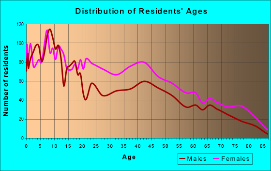
| Males: | 4,252 |
| Females: | 5,727 |
Males:
| This neighborhood: | 32.8 years |
| Whole city: | 34.8 years |
| This neighborhood: | 36.8 years |
| Whole city: | 38.2 years |
Average household size:
| Lane-Wooster: | 4.2 people |
| Akron: | 2.2 people |
Percentage of family households:
| Lane-Wooster: | 42.8% |
| Akron: | 39.9% |
| Here: | 15.1% |
| Akron: | 27.3% |
Percentage of married-couple families with children (among all households):
| Lane-Wooster: | 11.5% |
| Akron: | 16.8% |
Percentage of single-mother households (among all households):
| Lane-Wooster: | 36.1% |
| Akron: | 23.1% |
Percentage of never married males 15 years old and over:
Percentage of never married females 15 years old and over:
| Lane-Wooster: | 21.7% |
| Akron: | 23.2% |
Percentage of never married females 15 years old and over:
| Lane-Wooster: | 31.8% |
| city: | 22.0% |
Percentage of people that speak English not well or not at all:
| Lane-Wooster: | 0.5% |
| Akron: | 2.5% |
Percentage of people born in this state:
Percentage of people born in another U.S. state:
Percentage of native residents but born outside the U.S.:
Percentage of foreign born residents:
| Here: | 73.7% |
| Akron: | 76.3% |
Percentage of people born in another U.S. state:
| Lane-Wooster: | 22.6% |
| Akron: | 18.6% |
Percentage of native residents but born outside the U.S.:
| Here: | 1.7% |
| city: | 0.7% |
Percentage of foreign born residents:
| Here: | 3.1% |
| Akron: | 4.4% |

Owner-occupied
Renter-occupied


- Rooms in owner-occupied houses and condos in Lane-Wooster
- 01 room
- 02 rooms
- 2113 rooms
- 5834 rooms
- 4485 rooms
- 6576 rooms
- 7167 rooms
- 2228 rooms
- 1749+ rooms

- Rooms in renter-occupied apartments in Lane-Wooster
- 1571 room
- 1542 rooms
- 4123 rooms
- 7604 rooms
- 4965 rooms
- 4306 rooms
- 3607 rooms
- 3478 rooms
- 1289+ rooms
Owner-occupied
Renter-occupied

- Bedrooms in owner-occupied houses and condos in Lane-Wooster
- 0no bedroom
- 2241 bedroom
- 5002 bedrooms
- 1,3523 bedrooms
- 2644 bedrooms
- 1125+ bedrooms

- Bedrooms in renter-occupied apartments in Lane-Wooster
- 157no bedroom
- 4591 bedroom
- 1,0242 bedrooms
- 1,0053 bedrooms
- 3514 bedrooms
- 645+ bedrooms
Average number of cars or other vehicles available in houses/condos:
Average number of cars or other vehicles available in apartments:
| This neighborhood: | 1.4 |
| Akron: | 1.7 |
Average number of cars or other vehicles available in apartments:
| Here: | 1.2 |
| city: | 1.1 |
Percentage of units with a mortgage:
| Lane-Wooster: | 50.0% |
| Akron: | 55.4% |
Average estimated value of detached houses in 2022 (73.5% of all units):
| Lane-Wooster: | $71,190 |
| Ohio: | $254,366 |

- Year house built in Lane-Wooster
- 02020 or later
- 9262010 to 2019
- 8632000 to 2009
- 5861990 to 1999
- 2941980 to 1989
- 1821970 to 1979
- 4761960 to 1969
- 4861950 to 1959
- 3731940 to 1949
- 2,1511939 or earlier

City-data.com crime index for city in 2020 (higher means more crime):
| City: | 481.4 |
| U.S. average: | 219.5 |
Travel time to work (commute)
![Travel time to work (commute)]()
- 65Less than 5 minutes
- 3545 to 9 minutes
- 59910 to 14 minutes
- 53815 to 19 minutes
- 48820 to 24 minutes
- 27225 to 29 minutes
- 35730 to 34 minutes
- 17535 to 39 minutes
- 4640 to 44 minutes
- 50845 to 59 minutes
- 10860 to 89 minutes
- 4090 or more minutes

Means of transportation to work
![Means of transportation to work]()
- 77.9%3,090Drove a car alone
- 14.4%572Carpooled
- 8.0%318Bus
- 1.9%75Walked
- 2.4%94Other means
- 5.0%200Worked at home

Time leaving home to go to work
![Time leaving home to go to work]()
- 5512:00 a.m. to 4:59 a.m.
- 1425:00 a.m. to 5:29 a.m.
- 645:30 a.m. to 5:59 a.m.
- 3626:00 a.m. to 6:29 a.m.
- 2836:30 a.m. to 6:59 a.m.
- 3537:00 a.m. to 7:29 a.m.
- 3267:30 a.m. to 7:59 a.m.
- 3538:00 a.m. to 8:29 a.m.
- 2798:30 a.m. to 8:59 a.m.
- 1309:00 a.m. to 9:59 a.m.
- 25410:00 a.m. to 10:59 a.m.
- 20711:00 a.m. to 11:59 a.m.
- 47512:00 p.m. to 3:59 p.m.
- 3314:00 p.m. to 11:59 p.m.

Occupations of males:
- Percentage of males in management occupations (except farmers):
Here: 9.4% city: 7.7%
- Percentage of males in business and financial operations occupations:
Here: 4.3% city: 3.7%
- Percentage of males in life, physical, and social science occupations:
Here: 4.6% city: 1.2%
- Percentage of males in community and social services occupations:
Here: 1.7% city: 1.3%
- Percentage of males in education, training, and library occupations:
Here: 1.5% city: 2.7%
- Percentage of males in service occupations:
Here: 17.0% city: 17.1%
- Percentage of males in sales and office occupations:
Here: 22.5% city: 14.8%
- Percentage of males in construction, extraction, and maintenance occupations:
Here: 6.8% city: 7.5%
- Percentage of males in production occupations:
Here: 9.9% city: 13.5%
- Percentage of males in transportation occupations:
Here: 8.6% city: 5.5%
- Percentage of males in material moving occupations:
Here: 7.8% city: 9.4%
Occupations of females:
- Percentage of females in management occupations (except farmers):
Here: 8.4% city: 7.5%
- Percentage of females in business and financial operations occupations:
Here: 2.6% city: 4.5%
- Percentage of females in computer and mathematical occupations:
Here: 5.6% city: 1.2%
- Percentage of females in architecture and engineering occupations:
Here: 1.0% city: 0.4%
- Percentage of females in community and social services occupations:
Here: 11.1% city: 2.7%
- Percentage of females in education, training, and library occupations:
Here: 7.8% city: 6.7%
- Percentage of females in healthcare practitioners and technical occupations:
Here: 5.9% city: 8.2%
- Percentage of females in service occupations:
Here: 28.9% city: 26.6%
- Percentage of females in sales and office occupations:
Here: 21.4% city: 28.8%
- Percentage of females in production occupations:
Here: 3.2% city: 4.5%
- Percentage of females in material moving occupations:
Here: 3.8% city: 3.4%
Education in this neighborhood (subdivision or community):
- Percentage of people 3 years and older in K-12 schools:
Lane-Wooster: 31.6% Akron: 17.3%
- Percentage of people 3 years and older in undergraduate colleges:
Lane-Wooster: 6.4% Akron: 5.4%
- Percentage of people 3 years and older in grad. or professional schools:
Lane-Wooster: 2.0% Akron: 1.2%
- Percentage of students K-12 enrolled in private schools:
Lane-Wooster: 33.5% Akron: 11.4%
Percentage of population below poverty level:
| Lane-Wooster: | 32.9% |
| Akron: | 24.4% |
Median year renter moved in (as recorded in 2022):
| Lane-Wooster: | 2015 |
| Akron: | 2019 |
Percentage of married-couple families with both working:
| Lane-Wooster: | 201.3% |
| Akron: | 67.4% |

- 50.0%Utility gas
- 38.9%Electricity
- 4.3%Other fuel
- 3.3%No fuel used
- 1.9%Bottled, tank, or LP gas
- 1.7%Fuel oil, kerosene, etc.
Limited-access highways (interstate or state) in this neighborhood:
I- 76 (I- 77)
Length: 1.15 miles
Direction: E-W
Direction: E-W
Highways in this neighborhood:
State Rte 59 (Innerbelt, Martin Luther King Blvd)
Length: 2.87 miles
Directions: E-W, N-S, SW-NE
Directions: E-W, N-S, SW-NE
Vernon Odom Blvd (State Rte 261)
Length: 2.35 miles
Direction: E-W
Address range: 400 to 1386
Direction: E-W
Address range: 400 to 1386
Opportunity Pkwy (State Rte 261)
Length: 0.09 miles
Direction: E-W
Direction: E-W
Roads and streets:
Russell Ave
Length: 1.59 miles
Direction: E-W
Address range: 394 to 1099
Direction: E-W
Address range: 394 to 1099
East Ave
Length: 1.34 miles
Directions: N-S, SW-NE
Address range: 830 to 1476
Directions: N-S, SW-NE
Address range: 830 to 1476
W Thornton St
Length: 1.21 miles
Direction: E-W
Address range: 278 to 899
Direction: E-W
Address range: 278 to 899
Rhodes Ave
Length: 1.16 miles
Directions: N-S, SW-NE
Address range: 447 to 1069
Directions: N-S, SW-NE
Address range: 447 to 1069
Diagonal Rd
Length: 1.10 miles
Directions: E-W, SW-NE
Address range: 1081 to 1599
Directions: E-W, SW-NE
Address range: 1081 to 1599
Fess Ave
Length: 0.91 miles
Direction: E-W
Address range: 775 to 1156
Direction: E-W
Address range: 775 to 1156
Rand St
Length: 0.87 miles
Directions: E-W, N-S, SW-NE
Directions: E-W, N-S, SW-NE
Dart Ave
Length: 0.83 miles
Directions: N-S, SW-NE
Directions: N-S, SW-NE
Raymond St
Length: 0.81 miles
Directions: N-S, SE-NW
Address range: 622 to 1101
Directions: N-S, SE-NW
Address range: 622 to 1101
Bellevue Ave
Length: 0.76 miles
Direction: E-W
Address range: 590 to 899
Direction: E-W
Address range: 590 to 899
Easter Ave
Length: 0.76 miles
Direction: E-W
Address range: 500 to 899
Direction: E-W
Address range: 500 to 899
Longview Ave
Length: 0.74 miles
Directions: E-W, N-S, SE-NW, SW-NE
Address range: 639 to 960
Directions: E-W, N-S, SE-NW, SW-NE
Address range: 639 to 960
Howe St
Length: 0.73 miles
Direction: E-W
Address range: 339 to 649
Direction: E-W
Address range: 339 to 649
Bisson Ave
Length: 0.66 miles
Directions: E-W, SE-NW
Address range: 600 to 999
Directions: E-W, SE-NW
Address range: 600 to 999
Euclid Ave
Length: 0.63 miles
Direction: E-W
Address range: 561 to 799
Direction: E-W
Address range: 561 to 799
Superior Ave
Length: 0.62 miles
Directions: N-S, SE-NW
Address range: 1200 to 1579
Directions: N-S, SE-NW
Address range: 1200 to 1579
White Ave
Length: 0.49 miles
Directions: E-W, N-S, SE-NW
Address range: 1440 to 1699
Directions: E-W, N-S, SE-NW
Address range: 1440 to 1699
W Exchange St
Length: 0.49 miles
Direction: SE-NW
Address range: 287 to 498
Direction: SE-NW
Address range: 287 to 498
Manchester Rd
Length: 0.46 miles
Direction: N-S
Address range: 1138 to 1389
Direction: N-S
Address range: 1138 to 1389
Campbell St
Length: 0.45 miles
Directions: E-W, SW-NE
Address range: 340 to 519
Directions: E-W, SW-NE
Address range: 340 to 519
Sheridan Ave (Sheridan St)
Length: 0.44 miles
Directions: E-W, SE-NW
Address range: 780 to 960
Directions: E-W, SE-NW
Address range: 780 to 960
W Bartges St
Length: 0.43 miles
Direction: E-W
Address range: 351 to 499
Direction: E-W
Address range: 351 to 499
Biruta St
Length: 0.42 miles
Direction: E-W
Address range: 700 to 1059
Direction: E-W
Address range: 700 to 1059
Moon St
Length: 0.41 miles
Directions: N-S, SE-NW
Address range: 600 to 860
Directions: N-S, SE-NW
Address range: 600 to 860
la Croix Ave
Length: 0.40 miles
Direction: N-S
Address range: 976 to 1199
Direction: N-S
Address range: 976 to 1199
Rosamond Ave
Length: 0.38 miles
Direction: E-W
Address range: 754 to 1000
Direction: E-W
Address range: 754 to 1000
Blanche St
Length: 0.38 miles
Directions: E-W, N-S, SE-NW
Address range: 568 to 750
Directions: E-W, N-S, SE-NW
Address range: 568 to 750
Mallison Ave
Length: 0.38 miles
Directions: N-S, SE-NW
Address range: 601 to 851
Directions: N-S, SE-NW
Address range: 601 to 851
Douglas St
Length: 0.37 miles
Direction: N-S
Address range: 300 to 564
Direction: N-S
Address range: 300 to 564
Lane St
Length: 0.37 miles
Direction: N-S
Address range: 900 to 1199
Direction: N-S
Address range: 900 to 1199
Bishop St
Length: 0.36 miles
Directions: E-W, SW-NE
Address range: 300 to 549
Directions: E-W, SW-NE
Address range: 300 to 549
Nathan St
Length: 0.36 miles
Direction: N-S
Address range: 880 to 1072
Direction: N-S
Address range: 880 to 1072
Laurel Ave
Length: 0.35 miles
Direction: N-S
Address range: 900 to 1199
Direction: N-S
Address range: 900 to 1199
Snyder St
Length: 0.34 miles
Direction: N-S
Address range: 863 to 1070
Direction: N-S
Address range: 863 to 1070
Herman Ave
Length: 0.34 miles
Direction: N-S
Address range: 1100 to 1319
Direction: N-S
Address range: 1100 to 1319
Haynes St
Length: 0.34 miles
Directions: N-S, SE-NW
Address range: 865 to 1050
Directions: N-S, SE-NW
Address range: 865 to 1050
Bell St
Length: 0.33 miles
Directions: N-S, SW-NE
Address range: 300 to 530
Directions: N-S, SW-NE
Address range: 300 to 530
W Bowery St
Length: 0.33 miles
Direction: SW-NE
Address range: 824 to 999
Direction: SW-NE
Address range: 824 to 999
Pontiac Ave (Pontiac St)
Length: 0.33 miles
Directions: N-S, SW-NE
Address range: 1239 to 1499
Directions: N-S, SW-NE
Address range: 1239 to 1499
Winton Ave
Length: 0.32 miles
Directions: N-S, SE-NW
Address range: 1211 to 1399
Directions: N-S, SE-NW
Address range: 1211 to 1399
W Cedar St
Length: 0.31 miles
Direction: SE-NW
Address range: 294 to 499
Direction: SE-NW
Address range: 294 to 499
Fultz St
Length: 0.31 miles
Direction: E-W
Address range: 600 to 799
Direction: E-W
Address range: 600 to 799
Fern St
Length: 0.31 miles
Directions: N-S, SE-NW
Address range: 611 to 799
Directions: N-S, SE-NW
Address range: 611 to 799
Leonard St
Length: 0.30 miles
Direction: E-W
Address range: 600 to 899
Direction: E-W
Address range: 600 to 899
Dover Ave
Length: 0.30 miles
Direction: N-S
Address range: 1241 to 1399
Direction: N-S
Address range: 1241 to 1399
Diana Ave
Length: 0.29 miles
Direction: N-S
Address range: 800 to 1099
Direction: N-S
Address range: 800 to 1099
Berry Ave
Length: 0.29 miles
Direction: E-W
Address range: 340 to 451
Direction: E-W
Address range: 340 to 451
Moeller Ave
Length: 0.28 miles
Directions: E-W, N-S, SE-NW, SW-NE
Address range: 913 to 1047
Directions: E-W, N-S, SE-NW, SW-NE
Address range: 913 to 1047
Maxen Dr
Length: 0.27 miles
Directions: E-W, N-S, SE-NW
Address range: 1490 to 1686
Directions: E-W, N-S, SE-NW
Address range: 1490 to 1686
la Belle Ave
Length: 0.26 miles
Direction: E-W
Address range: 900 to 1099
Direction: E-W
Address range: 900 to 1099
Tyler St
Length: 0.26 miles
Directions: N-S, SE-NW
Address range: 1459 to 1599
Directions: N-S, SE-NW
Address range: 1459 to 1599
Belleflower Rd
Length: 0.26 miles
Directions: E-W, N-S, SW-NE
Address range: 1100 to 1299
Directions: E-W, N-S, SW-NE
Address range: 1100 to 1299
Andrew Ave (Andrew St)
Length: 0.26 miles
Direction: E-W
Address range: 900 to 1060
Direction: E-W
Address range: 900 to 1060
Mistletoe Rd
Length: 0.25 miles
Directions: E-W, SE-NW
Address range: 600 to 899
Directions: E-W, SE-NW
Address range: 600 to 899
Roslyn Ave
Length: 0.24 miles
Direction: N-S
Address range: 1353 to 1599
Direction: N-S
Address range: 1353 to 1599
Westerly Rd
Length: 0.23 miles
Directions: E-W, SE-NW, SW-NE
Directions: E-W, SE-NW, SW-NE
Zemil Ave
Length: 0.22 miles
Directions: N-S, SE-NW
Address range: 1600 to 1780
Directions: N-S, SE-NW
Address range: 1600 to 1780
Hartford Ave
Length: 0.21 miles
Direction: N-S
Address range: 1342 to 1499
Direction: N-S
Address range: 1342 to 1499
Cedar St
Length: 0.21 miles
Direction: SE-NW
Direction: SE-NW
Schumacher St (Schumacher Ave)
Length: 0.21 miles
Direction: N-S
Address range: 1000 to 1199
Direction: N-S
Address range: 1000 to 1199
Taylor St
Length: 0.21 miles
Direction: N-S
Address range: 1049 to 1170
Direction: N-S
Address range: 1049 to 1170
Roselle Ave
Length: 0.21 miles
Directions: E-W, SW-NE
Address range: 673 to 760
Directions: E-W, SW-NE
Address range: 673 to 760
Curl Ave
Length: 0.21 miles
Directions: E-W, N-S, SE-NW
Address range: 960 to 1039
Directions: E-W, N-S, SE-NW
Address range: 960 to 1039
Scheck St
Length: 0.20 miles
Directions: E-W, SE-NW
Address range: 419 to 511
Directions: E-W, SE-NW
Address range: 419 to 511
Parkdale Dr
Length: 0.20 miles
Directions: E-W, SE-NW
Address range: 500 to 579
Directions: E-W, SE-NW
Address range: 500 to 579
South St
Length: 0.19 miles
Direction: E-W
Address range: 472 to 529
Direction: E-W
Address range: 472 to 529
Courtland Ave
Length: 0.19 miles
Direction: E-W
Address range: 800 to 1175
Direction: E-W
Address range: 800 to 1175
Sunrise Dr
Length: 0.19 miles
Directions: N-S, SW-NE
Address range: 1200 to 1360
Directions: N-S, SW-NE
Address range: 1200 to 1360
Warner Ct
Length: 0.19 miles
Direction: E-W
Direction: E-W
Bristol Ter
Length: 0.18 miles
Directions: N-S, SW-NE
Address range: 1098 to 1199
Directions: N-S, SW-NE
Address range: 1098 to 1199
Washburn St (Washburn Ave)
Length: 0.17 miles
Direction: N-S
Address range: 1400 to 1571
Direction: N-S
Address range: 1400 to 1571
Rentar Ln
Length: 0.17 miles
Directions: N-S, SW-NE
Address range: 1200 to 1270
Directions: N-S, SW-NE
Address range: 1200 to 1270
Dorothy Ave
Length: 0.16 miles
Direction: E-W
Address range: 600 to 699
Direction: E-W
Address range: 600 to 699
Hardesty Blvd
Length: 0.16 miles
Direction: N-S
Address range: 1287 to 1499
Direction: N-S
Address range: 1287 to 1499
Ruth Ave
Length: 0.16 miles
Directions: N-S, SE-NW
Address range: 700 to 899
Directions: N-S, SE-NW
Address range: 700 to 899
Edgewood Ave
Length: 0.16 miles
Direction: N-S
Address range: 687 to 799
Direction: N-S
Address range: 687 to 799
Hite St
Length: 0.16 miles
Directions: E-W, N-S, SE-NW
Address range: 1290 to 1399
Directions: E-W, N-S, SE-NW
Address range: 1290 to 1399
Claudia Ave
Length: 0.15 miles
Direction: N-S
Address range: 1565 to 1653
Direction: N-S
Address range: 1565 to 1653
Norka St (Norka Ave)
Length: 0.15 miles
Direction: N-S
Address range: 1039 to 1160
Direction: N-S
Address range: 1039 to 1160
Manning Ave
Length: 0.15 miles
Directions: N-S, SE-NW
Address range: 1100 to 1199
Directions: N-S, SE-NW
Address range: 1100 to 1199
City View Dr (City View Ave)
Length: 0.14 miles
Direction: E-W
Address range: 690 to 799
Direction: E-W
Address range: 690 to 799
Albert Aly
Length: 0.14 miles
Direction: N-S
Address range: 913 to 1039
Direction: N-S
Address range: 913 to 1039
Harmon Ave
Length: 0.14 miles
Directions: N-S, SE-NW
Address range: 1200 to 1399
Directions: N-S, SE-NW
Address range: 1200 to 1399
Stevenson Pointe
Length: 0.14 miles
Directions: E-W, N-S, SE-NW, SW-NE
Directions: E-W, N-S, SE-NW, SW-NE
Leroy Ave
Length: 0.14 miles
Direction: N-S
Address range: 978 to 1050
Direction: N-S
Address range: 978 to 1050
Delba St
Length: 0.14 miles
Direction: N-S
Address range: 1575 to 1660
Direction: N-S
Address range: 1575 to 1660
Mercer Ave
Length: 0.13 miles
Directions: N-S, SE-NW
Address range: 1150 to 1299
Directions: N-S, SE-NW
Address range: 1150 to 1299
Hillcrest St
Length: 0.13 miles
Direction: N-S
Address range: 1368 to 1449
Direction: N-S
Address range: 1368 to 1449
Tressel Ave
Length: 0.13 miles
Direction: E-W
Address range: 943 to 999
Direction: E-W
Address range: 943 to 999
Tupelo Ave
Length: 0.13 miles
Direction: E-W
Address range: 890 to 999
Direction: E-W
Address range: 890 to 999
Raasch Ave
Length: 0.12 miles
Direction: SW-NE
Address range: 300 to 499
Direction: SW-NE
Address range: 300 to 499
Channelwood Cir
Length: 0.12 miles
Directions: E-W, N-S, SE-NW, SW-NE
Directions: E-W, N-S, SE-NW, SW-NE
Celina Ave
Length: 0.11 miles
Direction: N-S
Address range: 974 to 1046
Direction: N-S
Address range: 974 to 1046
Bonnie Brae Ave
Length: 0.10 miles
Direction: SW-NE
Address range: 300 to 399
Direction: SW-NE
Address range: 300 to 399
Blake Pl
Length: 0.10 miles
Directions: N-S, SE-NW
Address range: 1339 to 1399
Directions: N-S, SE-NW
Address range: 1339 to 1399
Gem Ave
Length: 0.10 miles
Direction: E-W
Address range: 688 to 739
Direction: E-W
Address range: 688 to 739
W Cedarwood St
Length: 0.10 miles
Direction: E-W
Address range: 447 to 499
Direction: E-W
Address range: 447 to 499
Everton Dr
Length: 0.09 miles
Directions: N-S, SE-NW
Address range: 1217 to 1265
Directions: N-S, SE-NW
Address range: 1217 to 1265
Arbutus Ct (Arbutus St)
Length: 0.09 miles
Direction: E-W
Address range: 639 to 699
Direction: E-W
Address range: 639 to 699
Ivy Ct
Length: 0.09 miles
Direction: E-W
Address range: 665 to 711
Direction: E-W
Address range: 665 to 711
Lillian St
Length: 0.09 miles
Direction: E-W
Address range: 300 to 419
Direction: E-W
Address range: 300 to 419
Keifer Ct
Length: 0.09 miles
Directions: E-W, N-S, SE-NW
Address range: 329 to 351
Directions: E-W, N-S, SE-NW
Address range: 329 to 351
Willow St
Length: 0.08 miles
Direction: SE-NW
Address range: 400 to 499
Direction: SE-NW
Address range: 400 to 499
Springhill Ter
Length: 0.08 miles
Direction: SE-NW
Address range: 700 to 750
Direction: SE-NW
Address range: 700 to 750
April Ct
Length: 0.08 miles
Direction: SW-NE
Address range: 2 to 66
Direction: SW-NE
Address range: 2 to 66
Bernice St
Length: 0.07 miles
Directions: N-S, SW-NE
Address range: 1400 to 1460
Directions: N-S, SW-NE
Address range: 1400 to 1460
Crestview Ave
Length: 0.07 miles
Direction: N-S
Address range: 1415 to 1459
Direction: N-S
Address range: 1415 to 1459
Mallison Ct
Length: 0.07 miles
Direction: E-W
Address range: 400 to 499
Direction: E-W
Address range: 400 to 499
Berry Ct
Length: 0.07 miles
Direction: N-S
Address range: 750 to 899
Direction: N-S
Address range: 750 to 899
Magennis Ave
Length: 0.06 miles
Directions: N-S, SE-NW
Address range: 900 to 999
Directions: N-S, SE-NW
Address range: 900 to 999
Krause Ct
Length: 0.06 miles
Directions: E-W, SE-NW
Address range: 638 to 780
Directions: E-W, SE-NW
Address range: 638 to 780
Portage Pl
Length: 0.06 miles
Direction: N-S
Direction: N-S
Monroe St
Length: 0.06 miles
Direction: E-W
Address range: 377 to 392
Direction: E-W
Address range: 377 to 392
Roulac Cir
Length: 0.06 miles
Directions: N-S, SE-NW
Address range: 1200 to 1299
Directions: N-S, SE-NW
Address range: 1200 to 1299
W Thornton St Exd
Length: 0.05 miles
Direction: E-W
Address range: 800 to 960
Direction: E-W
Address range: 800 to 960
Greenwood Ave
Length: 0.05 miles
Direction: N-S
Address range: 1426 to 1599
Direction: N-S
Address range: 1426 to 1599
Cedar Ct
Length: 0.05 miles
Direction: SW-NE
Address range: 370 to 499
Direction: SW-NE
Address range: 370 to 499
Rudd St
Length: 0.04 miles
Direction: N-S
Address range: 1514 to 1580
Direction: N-S
Address range: 1514 to 1580
Parsons Ct
Length: 0.04 miles
Direction: N-S
Address range: 839 to 860
Direction: N-S
Address range: 839 to 860
Rhoda Ct
Length: 0.04 miles
Direction: SW-NE
Address range: 1 to 35
Direction: SW-NE
Address range: 1 to 35
Abbott Ave
Length: 0.04 miles
Direction: N-S
Address range: 800 to 899
Direction: N-S
Address range: 800 to 899
Susan Ct
Length: 0.04 miles
Direction: SW-NE
Direction: SW-NE
Martin Pl
Length: 0.03 miles
Direction: N-S
Address range: 800 to 830
Direction: N-S
Address range: 800 to 830
Galat Way
Length: 0.03 miles
Direction: E-W
Address range: 900 to 933
Direction: E-W
Address range: 900 to 933
School St
Length: 0.03 miles
Direction: E-W
Address range: 669 to 701
Direction: E-W
Address range: 669 to 701
Innerbelt
Length: 0.02 miles
Direction: SW-NE
Direction: SW-NE
Other features:
Ohio Cnl
Length: 0.29 miles
Direction: SW-NE
Direction: SW-NE