Hartung (Hartung Section) neighborhood in Wyckoff, New Jersey (NJ), 07481 detailed profile
Settings
X


Business Search - 14 Million verified businesses
Area: 2.016 square miles
Population: 4,599
Population density:
| Hartung (Hartung Section): | 2,282 people per square mile |
| Wyckoff: | 2,522 people per square mile |

- 3,99283.1%White
- 4068.5%Hispanic or Latino
- 1994.1%Asian
- 1603.3%Two or more races
- 200.4%Some other race
- 130.3%American Indian
- 120.2%Black

Median household income in 2022:
| Hartung (Hartung Section): | $182,351 |
| New Jersey: | $96,346 |
Distribution of median household income
![Distribution of median household income]()
- 41Less than $10,000
- 123$10,000 to $19,999
- 101$20,000 to $29,999
- 185$30,000 to $39,999
- 107$40,000 to $49,999
- 73$50,000 to $59,999
- 67$60,000 to $74,999
- 86$75,000 to $99,999
- 187$100,000 to $124,999
- 172$125,000 to $149,999
- 286$150,000 to $199,999
- 674$200,000 or more

Distribution of owner-occupied house/condo value
![Distribution of owner-occupied house/condo value]()
- 382Less than $50,000
- 53$50,000 to $99,999
- 91$100,000 to $149,999
- 24$150,000 to $199,999
- 43$200,000 to $249,999
- 16$250,000 to $299,999
- 149$300,000 to $399,999
- 127$400,000 to $499,999
- 245$500,000 to $749,999
- 461$750,000 to $999,999
- 545$1,000,000 or more

Distribution of rent paid by renters
![Distribution of rent paid by renters]()
- 57Less than $100
- 35$700 to $799
- 22$800 to $899
- 18$900 to $999
- 121$1,000 to $1,249
- 73$1,250 to $1,499
- 131$1,500 to $1,999
- 317$2,000 or more

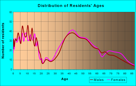
| Males: | 2,290 |
| Females: | 2,309 |
| Males: | 46.2 years |
| Females: | 49.7 years |
Average household size:
| Hartung (Hartung Section): | 7.2 people |
| New Jersey: | 2.6 people |
Percentage of family households:
| Hartung (Hartung Section): | 52.3% |
| New Jersey: | 47.0% |
| Here: | 65.0% |
| New Jersey: | 49.9% |
Percentage of married-couple families with children (among all households):
| Hartung (Hartung Section): | 33.1% |
| New Jersey: | 51.5% |
Percentage of single-mother households (among all households):
| Hartung (Hartung Section): | 1.6% |
| New Jersey: | 7.6% |
Percentage of never married males 15 years old and over:
Percentage of never married females 15 years old and over:
| Hartung (Hartung Section): | 11.2% |
| New Jersey: | 18.2% |
Percentage of never married females 15 years old and over:
| Hartung (Hartung Section): | 15.2% |
| New Jersey: | 16.6% |
Percentage of people that speak English not well or not at all:
| Hartung (Hartung Section): | 3.5% |
| New Jersey: | 6.5% |
Percentage of people born in this state:
Percentage of people born in another U.S. state:
Percentage of native residents but born outside the U.S.:
Percentage of foreign born residents:
| Here: | 57.3% |
| New Jersey: | 50.7% |
Percentage of people born in another U.S. state:
| Hartung (Hartung Section): | 29.6% |
| New Jersey: | 23.4% |
Percentage of native residents but born outside the U.S.:
| Here: | 1.2% |
| New Jersey: | 2.4% |
Percentage of foreign born residents:
| Here: | 11.9% |
| New Jersey: | 23.5% |

Owner-occupied
Renter-occupied


- Rooms in owner-occupied houses and condos in Hartung <
> - 01 room
- 42 rooms
- 2443 rooms
- 2874 rooms
- 695 rooms
- 1446 rooms
- 1967 rooms
- 3278 rooms
- 6129+ rooms

- Rooms in renter-occupied apartments in Hartung <
> - 701 room
- 312 rooms
- 803 rooms
- 854 rooms
- 1015 rooms
- 326 rooms
- 317 rooms
- 1078 rooms
- 449+ rooms
Owner-occupied
Renter-occupied

- Bedrooms in owner-occupied houses and condos in Hartung <
> - 14no bedroom
- 1911 bedroom
- 1442 bedrooms
- 3233 bedrooms
- 6584 bedrooms
- 2555+ bedrooms

- Bedrooms in renter-occupied apartments in Hartung <
> - 70no bedroom
- 1261 bedroom
- 562 bedrooms
- 933 bedrooms
- 864 bedrooms
- 555+ bedrooms
Average number of cars or other vehicles available in houses/condos:
Average number of cars or other vehicles available in apartments:
| This neighborhood: | 1.9 |
| New Jersey: | 2.0 |
Average number of cars or other vehicles available in apartments:
| Here: | |
| New Jersey: |
Percentage of units with a mortgage:
| Hartung (Hartung Section): | 58.9% |
| New Jersey: | 63.3% |
Average estimated value of detached houses in 2022 (77.6% of all units):
| Hartung (Hartung Section): | $863,725 |
| New Jersey: | $537,591 |

- Year house built in Hartung <
> - 642020 or later
- 832010 to 2019
- 1162000 to 2009
- 1771990 to 1999
- 2891980 to 1989
- 1511970 to 1979
- 4081960 to 1969
- 3471950 to 1959
- 671940 to 1949
- 2651939 or earlier

City-data.com crime index for place in 2020 (higher means more crime):
| City: | 31.0 |
| U.S. average: | 219.5 |
Travel time to work (commute)
![Travel time to work (commute)]()
- 76Less than 5 minutes
- 1075 to 9 minutes
- 17810 to 14 minutes
- 24515 to 19 minutes
- 22220 to 24 minutes
- 8325 to 29 minutes
- 15130 to 34 minutes
- 5135 to 39 minutes
- 7940 to 44 minutes
- 24845 to 59 minutes
- 15360 to 89 minutes
- 4190 or more minutes

Means of transportation to work
![Means of transportation to work]()
- 67.9%1,481Drove a car alone
- 3.6%79Carpooled
- 4.1%89Bus
- 4.2%91Subway or elevated rail
- 2.0%44Long-distance train or commuter rail
- 3.6%78Light rail, streetcar or trolley
- 5.6%122Ferryboat
- 4.6%101Walked
- 6.3%137Other means
- 20.4%444Worked at home

Time leaving home to go to work
![Time leaving home to go to work]()
- 5012:00 a.m. to 4:59 a.m.
- 305:00 a.m. to 5:29 a.m.
- 395:30 a.m. to 5:59 a.m.
- 1196:00 a.m. to 6:29 a.m.
- 1166:30 a.m. to 6:59 a.m.
- 2007:00 a.m. to 7:29 a.m.
- 1817:30 a.m. to 7:59 a.m.
- 3988:00 a.m. to 8:29 a.m.
- 1388:30 a.m. to 8:59 a.m.
- 2269:00 a.m. to 9:59 a.m.
- 4410:00 a.m. to 10:59 a.m.
- 3011:00 a.m. to 11:59 a.m.
- 4412:00 p.m. to 3:59 p.m.
- 194:00 p.m. to 11:59 p.m.

Occupations of males:
- Percentage of males in management occupations (except farmers):
Here: 21.1% New Jersey: 13.9%
- Percentage of males in business and financial operations occupations:
Here: 8.2% New Jersey: 6.9%
- Percentage of males in computer and mathematical occupations:
Here: 1.1% New Jersey: 6.5%
- Percentage of males in architecture and engineering occupations:
Here: 1.3% New Jersey: 3.1%
- Percentage of males in life, physical, and social science occupations:
Here: 1.6% New Jersey: 1.2%
- Percentage of males in community and social services occupations:
Here: 2.2% New Jersey: 1.1%
- Percentage of males in legal occupations:
Here: 9.4% New Jersey: 1.5%
- Percentage of males in education, training, and library occupations:
Here: 6.1% New Jersey: 3.6%
- Percentage of males in arts, design, entertainment, sports, and media occupations:
Here: 3.1% New Jersey: 2.0%
- Percentage of males in healthcare practitioners and technical occupations:
Here: 8.0% New Jersey: 3.2%
- Percentage of males in service occupations:
Here: 3.7% New Jersey: 12.9%
- Percentage of males in sales and office occupations:
Here: 25.0% New Jersey: 15.3%
- Percentage of males in construction, extraction, and maintenance occupations:
Here: 1.2% New Jersey: 8.1%
- Percentage of males in transportation occupations:
Here: 2.0% New Jersey: 6.5%
- Percentage of males in material moving occupations:
Here: 1.6% New Jersey: 4.7%
Occupations of females:
- Percentage of females in management occupations (except farmers):
Here: 11.8% New Jersey: 10.4%
- Percentage of females in business and financial operations occupations:
Here: 5.5% New Jersey: 7.3%
- Percentage of females in community and social services occupations:
Here: 1.1% New Jersey: 2.6%
- Percentage of females in legal occupations:
Here: 7.6% New Jersey: 1.6%
- Percentage of females in education, training, and library occupations:
Here: 16.5% New Jersey: 11.4%
- Percentage of females in arts, design, entertainment, sports, and media occupations:
Here: 1.5% New Jersey: 2.2%
- Percentage of females in healthcare practitioners and technical occupations:
Here: 11.5% New Jersey: 9.6%
- Percentage of females in service occupations:
Here: 15.2% New Jersey: 17.2%
- Percentage of females in sales and office occupations:
Here: 21.6% New Jersey: 26.7%
- Percentage of females in material moving occupations:
Here: 6.3% New Jersey: 2.4%
Education in this neighborhood (subdivision or community):
- Percentage of people 3 years and older in K-12 schools:
Hartung (Hartung Section): 23.0% New Jersey: 16.6%
- Percentage of people 3 years and older in undergraduate colleges:
Hartung (Hartung Section): 4.3% New Jersey: 4.9%
- Percentage of people 3 years and older in grad. or professional schools:
Hartung (Hartung Section): 3.0% New Jersey: 1.6%
- Percentage of students K-12 enrolled in private schools:
Hartung (Hartung Section): 34.2% New Jersey: 12.7%
Percentage of population below poverty level:
| Hartung (Hartung Section): | 1.6% |
| New Jersey: | 9.7% |
Median year owner moved in (as recorded in 2022):
| Hartung (Hartung Section): | 2003 |
| New Jersey: | 2008 |
Percentage of married-couple families with both working:
| Hartung (Hartung Section): | 80.9% |
| New Jersey: | 72.0% |

- 77.0%Utility gas
- 7.8%Wood
- 5.4%Electricity
- 4.7%Fuel oil, kerosene, etc.
- 3.4%Other fuel
- 1.7%Bottled, tank, or LP gas
Highways in this neighborhood:
State Rte 208
Length: 1.92 miles
Direction: SE-NW
Address range: 421 to 499
Direction: SE-NW
Address range: 421 to 499
Roads and streets:
Wyckoff Ave
Length: 2.90 miles
Directions: E-W, N-S, SE-NW, SW-NE
Address range: 290 to 821
Directions: E-W, N-S, SE-NW, SW-NE
Address range: 290 to 821
James Way
Length: 1.31 miles
Directions: E-W, N-S, SE-NW, SW-NE
Address range: 301 to 515
Directions: E-W, N-S, SE-NW, SW-NE
Address range: 301 to 515
William Way
Length: 1.03 miles
Directions: E-W, N-S, SE-NW, SW-NE
Address range: 300 to 499
Directions: E-W, N-S, SE-NW, SW-NE
Address range: 300 to 499
Franklin Ave
Length: 1.03 miles
Directions: E-W, SE-NW
Address range: 400 to 568
Directions: E-W, SE-NW
Address range: 400 to 568
Carlton Rd
Length: 0.98 miles
Directions: E-W, SW-NE
Address range: 400 to 544
Directions: E-W, SW-NE
Address range: 400 to 544
Clinton Ave
Length: 0.92 miles
Direction: E-W
Address range: 401 to 555
Direction: E-W
Address range: 401 to 555
Weymouth Dr
Length: 0.88 miles
Directions: E-W, N-S, SE-NW, SW-NE
Address range: 400 to 511
Directions: E-W, N-S, SE-NW, SW-NE
Address range: 400 to 511
Cedarhill Ave
Length: 0.75 miles
Directions: E-W, N-S, SW-NE
Address range: 400 to 525
Directions: E-W, N-S, SW-NE
Address range: 400 to 525
Helena Ave
Length: 0.73 miles
Directions: E-W, SE-NW
Address range: 500 to 598
Directions: E-W, SE-NW
Address range: 500 to 598
Hartung Dr
Length: 0.71 miles
Directions: E-W, N-S, SW-NE
Address range: 400 to 545
Directions: E-W, N-S, SW-NE
Address range: 400 to 545
Old Post Rd
Length: 0.68 miles
Directions: E-W, N-S, SW-NE
Address range: 451 to 598
Directions: E-W, N-S, SW-NE
Address range: 451 to 598
Woodbury Dr
Length: 0.62 miles
Directions: E-W, SE-NW
Address range: 400 to 474
Directions: E-W, SE-NW
Address range: 400 to 474
Russel Ave
Length: 0.57 miles
Directions: E-W, N-S, SE-NW, SW-NE
Address range: 400 to 486
Directions: E-W, N-S, SE-NW, SW-NE
Address range: 400 to 486
Fairfield Rd
Length: 0.53 miles
Directions: E-W, N-S, SE-NW
Address range: 442 to 499
Directions: E-W, N-S, SE-NW
Address range: 442 to 499
W Main St
Length: 0.51 miles
Direction: E-W
Address range: 400 to 504
Direction: E-W
Address range: 400 to 504
Oldwoods Rd
Length: 0.50 miles
Directions: E-W, N-S, SE-NW
Address range: 455 to 557
Directions: E-W, N-S, SE-NW
Address range: 455 to 557
Patton Pl
Length: 0.49 miles
Directions: E-W, N-S, SW-NE
Address range: 400 to 463
Directions: E-W, N-S, SW-NE
Address range: 400 to 463
Wellington Dr
Length: 0.49 miles
Directions: E-W, N-S, SE-NW
Address range: 496 to 559
Directions: E-W, N-S, SE-NW
Address range: 496 to 559
Lawlins Rd
Length: 0.48 miles
Directions: E-W, N-S, SE-NW, SW-NE
Address range: 610 to 698
Directions: E-W, N-S, SE-NW, SW-NE
Address range: 610 to 698
Ellis Pl
Length: 0.47 miles
Directions: E-W, N-S, SE-NW, SW-NE
Address range: 416 to 484
Directions: E-W, N-S, SE-NW, SW-NE
Address range: 416 to 484
Meer Ave
Length: 0.47 miles
Directions: N-S, SW-NE
Address range: 401 to 485
Directions: N-S, SW-NE
Address range: 401 to 485
Eder Ave
Length: 0.44 miles
Direction: E-W
Address range: 500 to 573
Direction: E-W
Address range: 500 to 573
George Pl
Length: 0.42 miles
Directions: E-W, SE-NW
Address range: 414 to 473
Directions: E-W, SE-NW
Address range: 414 to 473
Bromley Pl
Length: 0.41 miles
Directions: E-W, N-S, SE-NW, SW-NE
Address range: 400 to 499
Directions: E-W, N-S, SE-NW, SW-NE
Address range: 400 to 499
Miller Rd
Length: 0.40 miles
Directions: E-W, N-S, SE-NW
Address range: 527 to 591
Directions: E-W, N-S, SE-NW
Address range: 527 to 591
Overlook Dr (Overlook Rd)
Length: 0.40 miles
Directions: E-W, N-S, SE-NW, SW-NE
Address range: 526 to 610
Directions: E-W, N-S, SE-NW, SW-NE
Address range: 526 to 610
Covington Pl
Length: 0.39 miles
Directions: E-W, N-S, SE-NW
Address range: 495 to 568
Directions: E-W, N-S, SE-NW
Address range: 495 to 568
Spring Meadow Dr
Length: 0.38 miles
Directions: E-W, SE-NW
Directions: E-W, SE-NW
Wishing Well Rd
Length: 0.33 miles
Directions: E-W, N-S, SE-NW, SW-NE
Address range: 600 to 652
Directions: E-W, N-S, SE-NW, SW-NE
Address range: 600 to 652
Calvin Ct
Length: 0.31 miles
Directions: E-W, SE-NW
Address range: 300 to 347
Directions: E-W, SE-NW
Address range: 300 to 347
Victor Way
Length: 0.26 miles
Direction: SW-NE
Address range: 429 to 485
Direction: SW-NE
Address range: 429 to 485
Lake Rd
Length: 0.25 miles
Direction: E-W
Address range: 400 to 451
Direction: E-W
Address range: 400 to 451
Waverly Rd
Length: 0.25 miles
Direction: E-W
Address range: 500 to 542
Direction: E-W
Address range: 500 to 542
Quackenbush Ave
Length: 0.25 miles
Direction: N-S
Address range: 625 to 674
Direction: N-S
Address range: 625 to 674
Ackerson Ave
Length: 0.25 miles
Direction: E-W
Address range: 467 to 499
Direction: E-W
Address range: 467 to 499
Sturbridge Rd
Length: 0.24 miles
Directions: E-W, SE-NW, SW-NE
Address range: 345 to 374
Directions: E-W, SE-NW, SW-NE
Address range: 345 to 374
Snyder Rd
Length: 0.22 miles
Direction: SW-NE
Address range: 400 to 440
Direction: SW-NE
Address range: 400 to 440
Bohny Dr
Length: 0.22 miles
Direction: SE-NW
Address range: 300 to 337
Direction: SE-NW
Address range: 300 to 337
Chestnut St
Length: 0.22 miles
Directions: E-W, SE-NW, SW-NE
Address range: 531 to 567
Directions: E-W, SE-NW, SW-NE
Address range: 531 to 567
Farview Ave
Length: 0.22 miles
Directions: N-S, SW-NE
Address range: 520 to 538
Directions: N-S, SW-NE
Address range: 520 to 538
Oldwoods Rd E
Length: 0.22 miles
Directions: E-W, N-S, SE-NW, SW-NE
Directions: E-W, N-S, SE-NW, SW-NE
Drury Ln
Length: 0.21 miles
Direction: SW-NE
Address range: 400 to 441
Direction: SW-NE
Address range: 400 to 441
Poplar Ct
Length: 0.21 miles
Direction: E-W
Address range: 1 to 578
Direction: E-W
Address range: 1 to 578
Fairview Pl
Length: 0.20 miles
Direction: N-S
Address range: 617 to 656
Direction: N-S
Address range: 617 to 656
Berkeley Dr (Berkeley Way)
Length: 0.20 miles
Directions: N-S, SW-NE
Address range: 473 to 507
Directions: N-S, SW-NE
Address range: 473 to 507
Russell Ave
Length: 0.20 miles
Directions: E-W, N-S, SW-NE
Address range: 501 to 543
Directions: E-W, N-S, SW-NE
Address range: 501 to 543
Orchard Rd
Length: 0.19 miles
Direction: SE-NW
Address range: 332 to 371
Direction: SE-NW
Address range: 332 to 371
Sparrowbush Rd
Length: 0.19 miles
Direction: N-S
Address range: 551 to 599
Direction: N-S
Address range: 551 to 599
Maple Ave
Length: 0.19 miles
Directions: E-W, N-S
Address range: 631 to 654
Directions: E-W, N-S
Address range: 631 to 654
Cresthaven Rd
Length: 0.18 miles
Directions: N-S, SW-NE
Address range: 566 to 607
Directions: N-S, SW-NE
Address range: 566 to 607
Fairmont Rd
Length: 0.18 miles
Directions: N-S, SE-NW, SW-NE
Address range: 533 to 565
Directions: N-S, SE-NW, SW-NE
Address range: 533 to 565
Woodfield Rd
Length: 0.17 miles
Directions: N-S, SW-NE
Address range: 600 to 625
Directions: N-S, SW-NE
Address range: 600 to 625
Concord Pl
Length: 0.16 miles
Direction: N-S
Address range: 474 to 540
Direction: N-S
Address range: 474 to 540
Taunton Rd
Length: 0.16 miles
Direction: N-S
Address range: 530 to 564
Direction: N-S
Address range: 530 to 564
Kelly Ct
Length: 0.15 miles
Direction: E-W
Address range: 421 to 446
Direction: E-W
Address range: 421 to 446
Cornwall Ct
Length: 0.14 miles
Direction: E-W
Address range: 400 to 427
Direction: E-W
Address range: 400 to 427
William Way N
Length: 0.14 miles
Directions: N-S, SE-NW
Address range: 417 to 456
Directions: N-S, SE-NW
Address range: 417 to 456
Lawlins Park
Length: 0.13 miles
Directions: N-S, SW-NE
Address range: 10 to 210
Directions: N-S, SW-NE
Address range: 10 to 210
Obrien Ct
Length: 0.13 miles
Directions: E-W, SW-NE
Address range: 400 to 499
Directions: E-W, SW-NE
Address range: 400 to 499
Vance Ave
Length: 0.12 miles
Directions: N-S, SW-NE
Address range: 467 to 499
Directions: N-S, SW-NE
Address range: 467 to 499
Highland Ave
Length: 0.12 miles
Direction: E-W
Address range: 409 to 499
Direction: E-W
Address range: 409 to 499
Lee Ct
Length: 0.12 miles
Direction: E-W
Address range: 534 to 561
Direction: E-W
Address range: 534 to 561
Hamden Ct
Length: 0.12 miles
Direction: E-W
Address range: 412 to 438
Direction: E-W
Address range: 412 to 438
Hidden Valley Ct
Length: 0.12 miles
Directions: E-W, N-S, SE-NW
Directions: E-W, N-S, SE-NW
Buena Vista Way
Length: 0.11 miles
Direction: N-S
Address range: 590 to 613
Direction: N-S
Address range: 590 to 613
Florence Ave
Length: 0.11 miles
Direction: SW-NE
Address range: 454 to 480
Direction: SW-NE
Address range: 454 to 480
Mills Pl
Length: 0.11 miles
Direction: SE-NW
Address range: 300 to 334
Direction: SE-NW
Address range: 300 to 334
Aspen Ln
Length: 0.11 miles
Directions: E-W, N-S, SE-NW, SW-NE
Address range: 500 to 514
Directions: E-W, N-S, SE-NW, SW-NE
Address range: 500 to 514
Suzanette Pl
Length: 0.11 miles
Direction: E-W
Address range: 500 to 527
Direction: E-W
Address range: 500 to 527
Robin Pl
Length: 0.11 miles
Direction: N-S
Address range: 550 to 569
Direction: N-S
Address range: 550 to 569
Everett Ave
Length: 0.10 miles
Direction: N-S
Direction: N-S
Shelbourne Dr
Length: 0.10 miles
Direction: SE-NW
Direction: SE-NW
Lawrence Rd
Length: 0.10 miles
Direction: SE-NW
Direction: SE-NW
Barbara Ave
Length: 0.10 miles
Direction: SW-NE
Address range: 451 to 470
Direction: SW-NE
Address range: 451 to 470
Farview Ct
Length: 0.10 miles
Direction: E-W
Address range: 500 to 599
Direction: E-W
Address range: 500 to 599
S Woodfield Rd
Length: 0.10 miles
Directions: N-S, SW-NE
Address range: 574 to 599
Directions: N-S, SW-NE
Address range: 574 to 599
Evergreen Dr
Length: 0.09 miles
Direction: E-W
Direction: E-W
Burritt Pl
Length: 0.09 miles
Direction: E-W
Address range: 559 to 569
Direction: E-W
Address range: 559 to 569
Eisenhower Ct
Length: 0.09 miles
Directions: N-S, SW-NE
Address range: 479 to 499
Directions: N-S, SW-NE
Address range: 479 to 499
Paine Rd
Length: 0.09 miles
Direction: SW-NE
Address range: 483 to 499
Direction: SW-NE
Address range: 483 to 499
Booth Ct
Length: 0.08 miles
Direction: SW-NE
Address range: 484 to 499
Direction: SW-NE
Address range: 484 to 499
Hampshire Ct
Length: 0.08 miles
Directions: N-S, SE-NW, SW-NE
Address range: 372 to 399
Directions: N-S, SE-NW, SW-NE
Address range: 372 to 399
Parmley St
Length: 0.07 miles
Directions: E-W, N-S, SW-NE
Directions: E-W, N-S, SW-NE
Parmley Ave (Parmley St)
Length: 0.07 miles
Direction: E-W
Address range: 400 to 499
Direction: E-W
Address range: 400 to 499
Stony Brook Ln
Length: 0.07 miles
Direction: N-S
Address range: 500 to 516
Direction: N-S
Address range: 500 to 516
Mystic Ct
Length: 0.07 miles
Directions: SE-NW, SW-NE
Address range: 449 to 470
Directions: SE-NW, SW-NE
Address range: 449 to 470
Miller Ct
Length: 0.07 miles
Direction: E-W
Address range: 500 to 599
Direction: E-W
Address range: 500 to 599
Massey Ct
Length: 0.07 miles
Directions: N-S, SW-NE
Address range: 455 to 474
Directions: N-S, SW-NE
Address range: 455 to 474
Old Mill Ln
Length: 0.07 miles
Direction: SW-NE
Address range: 400 to 499
Direction: SW-NE
Address range: 400 to 499
Nydam Ln
Length: 0.06 miles
Direction: N-S
Address range: 1 to 7
Direction: N-S
Address range: 1 to 7
Domm Ct
Length: 0.06 miles
Direction: N-S
Address range: 800 to 822
Direction: N-S
Address range: 800 to 822
Charles Ave
Length: 0.05 miles
Direction: N-S
Direction: N-S
Godwin Ave
Length: 0.05 miles
Direction: N-S
Address range: 379 to 395
Direction: N-S
Address range: 379 to 395
Alex Ct
Length: 0.05 miles
Directions: N-S, SW-NE
Address range: 1 to 99
Directions: N-S, SW-NE
Address range: 1 to 99
Edwards St
Length: 0.05 miles
Direction: N-S
Direction: N-S
Pinewood Dr
Length: 0.04 miles
Direction: E-W
Address range: 363 to 374
Direction: E-W
Address range: 363 to 374
Frances Pl
Length: 0.04 miles
Direction: E-W
Direction: E-W
Suger Bush Ct
Length: 0.03 miles
Direction: SW-NE
Direction: SW-NE
Sugar Bush Ct
Length: 0.02 miles
Direction: SW-NE
Address range: 600 to 618
Direction: SW-NE
Address range: 600 to 618
Railroad features:
New York Susquehanna and Western Rlwy
Length: 1.01 miles
Direction: E-W
Direction: E-W
Other features:
Goffle Brk
Length: 1.17 miles
Directions: E-W, N-S, SE-NW, SW-NE
Directions: E-W, N-S, SE-NW, SW-NE
Hohokus Crk
Length: 1.08 miles
Directions: E-W, N-S, SE-NW, SW-NE
Directions: E-W, N-S, SE-NW, SW-NE
Deep Brk
Length: 0.60 miles
Directions: N-S, SE-NW, SW-NE
Directions: N-S, SE-NW, SW-NE
Spring Lake Brk
Length: 0.28 miles
Directions: N-S, SE-NW, SW-NE
Directions: N-S, SE-NW, SW-NE
Sicoma Br
Length: 0.21 miles
Directions: N-S, SE-NW, SW-NE
Directions: N-S, SE-NW, SW-NE