East Akron neighborhood in Akron, Ohio (OH), 44305, 44306 detailed profile
Settings
X


Business Search - 14 Million verified businesses
Area: 3.441 square miles
Population: 9,618
Population density:
| East Akron: | 2,795 people per square mile |
| Akron: | 3,037 people per square mile |

- 4,39033.7%Black
- 3,47126.7%White
- 1,2489.6%Some other race
- 1,1298.7%Asian
- 1,1218.6%Hispanic or Latino
- 8636.6%Two or more races
- 7165.5%Native Hawaiian and Other
Pacific Islander - 800.6%American Indian

Distribution of median household income
![Distribution of median household income]()
- 444Less than $10,000
- 939$10,000 to $19,999
- 740$20,000 to $29,999
- 762$30,000 to $39,999
- 857$40,000 to $49,999
- 427$50,000 to $59,999
- 570$60,000 to $74,999
- 458$75,000 to $99,999
- 393$100,000 to $124,999
- 78$125,000 to $149,999
- 504$150,000 to $199,999
- 28$200,000 or more

Distribution of owner-occupied house/condo value
![Distribution of owner-occupied house/condo value]()
- 2,598Less than $50,000
- 2,307$50,000 to $99,999
- 482$100,000 to $149,999
- 280$150,000 to $199,999
- 210$200,000 to $249,999
- 77$250,000 to $299,999
- 42$300,000 to $399,999
- 637$500,000 to $749,999
- 15$750,000 to $999,999

Distribution of rent paid by renters
![Distribution of rent paid by renters]()
- 390Less than $100
- 547$100 to $199
- 438$200 to $299
- 504$300 to $399
- 775$400 to $499
- 649$500 to $599
- 580$600 to $699
- 951$700 to $799
- 787$800 to $899
- 43$900 to $999
- 259$1,000 to $1,249
- 135$1,250 to $1,499
- 42$1,500 to $1,999

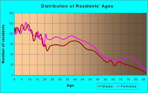
| Males: | 4,591 |
| Females: | 5,026 |
Males:
| This neighborhood: | 37.7 years |
| Whole city: | 34.8 years |
| This neighborhood: | 41.1 years |
| Whole city: | 38.2 years |
Average household size:
| East Akron: | 4.5 people |
| Akron: | 2.2 people |
Percentage of family households:
| East Akron: | 38.1% |
| Akron: | 39.9% |
| Here: | 23.5% |
| Akron: | 27.3% |
Percentage of married-couple families with children (among all households):
| East Akron: | 20.3% |
| Akron: | 16.8% |
Percentage of single-mother households (among all households):
| East Akron: | 24.7% |
| Akron: | 23.1% |
Percentage of never married males 15 years old and over:
Percentage of never married females 15 years old and over:
| East Akron: | 20.7% |
| Akron: | 23.2% |
Percentage of never married females 15 years old and over:
| East Akron: | 26.5% |
| city: | 22.0% |
Percentage of people that speak English not well or not at all:
| East Akron: | 1.3% |
| Akron: | 2.5% |
Percentage of people born in this state:
Percentage of people born in another U.S. state:
Percentage of native residents but born outside the U.S.:
Percentage of foreign born residents:
| Here: | 83.0% |
| Akron: | 76.3% |
Percentage of people born in another U.S. state:
| East Akron: | 13.8% |
| Akron: | 18.6% |
Percentage of native residents but born outside the U.S.:
| Here: | 0.5% |
| city: | 0.7% |
Percentage of foreign born residents:
| Here: | 3.8% |
| Akron: | 4.4% |

Owner-occupied
Renter-occupied


- Rooms in owner-occupied houses and condos in East Akron
- 6371 room
- 5582 rooms
- 7843 rooms
- 3244 rooms
- 7405 rooms
- 4936 rooms
- 3867 rooms
- 2028 rooms
- 2709+ rooms

- Rooms in renter-occupied apartments in East Akron
- 2,0561 room
- 1242 rooms
- 1683 rooms
- 8954 rooms
- 8665 rooms
- 3956 rooms
- 4947 rooms
- 2278 rooms
- 2329+ rooms
Owner-occupied
Renter-occupied

- Bedrooms in owner-occupied houses and condos in East Akron
- 637no bedroom
- 4921 bedroom
- 7322 bedrooms
- 1,2383 bedrooms
- 2344 bedrooms
- 2655+ bedrooms

- Bedrooms in renter-occupied apartments in East Akron
- 2,056no bedroom
- 3771 bedroom
- 1,0972 bedrooms
- 8173 bedrooms
- 2364 bedrooms
- 5065+ bedrooms
Average number of cars or other vehicles available in houses/condos:
Average number of cars or other vehicles available in apartments:
| This neighborhood: | 1.5 |
| Akron: | 1.7 |
Average number of cars or other vehicles available in apartments:
| Here: | 1.0 |
| city: | 1.1 |
Percentage of units with a mortgage:
| East Akron: | 45.5% |
| Akron: | 55.4% |
Average estimated value of detached houses in 2022 (69.0% of all units):
| East Akron: | $86,582 |
| Ohio: | $254,366 |

- Year house built in East Akron
- 152020 or later
- 2552010 to 2019
- 1942000 to 2009
- 8261990 to 1999
- 2461980 to 1989
- 7251970 to 1979
- 7361960 to 1969
- 8501950 to 1959
- 7071940 to 1949
- 1,6351939 or earlier

City-data.com crime index for city in 2020 (higher means more crime):
| City: | 481.4 |
| U.S. average: | 219.5 |
Travel time to work (commute)
![Travel time to work (commute)]()
- 72Less than 5 minutes
- 3775 to 9 minutes
- 1,17810 to 14 minutes
- 90415 to 19 minutes
- 58520 to 24 minutes
- 33525 to 29 minutes
- 46530 to 34 minutes
- 15135 to 39 minutes
- 10140 to 44 minutes
- 40945 to 59 minutes
- 10560 to 89 minutes
- 13590 or more minutes

Means of transportation to work
![Means of transportation to work]()
- 69.0%2,545Drove a car alone
- 25.8%952Carpooled
- 11.0%404Bus
- 3.0%110Bicycle
- 6.4%237Walked
- 4.0%146Other means
- 17.7%654Worked at home

Time leaving home to go to work
![Time leaving home to go to work]()
- 42712:00 a.m. to 4:59 a.m.
- 905:00 a.m. to 5:29 a.m.
- 4255:30 a.m. to 5:59 a.m.
- 3096:00 a.m. to 6:29 a.m.
- 3356:30 a.m. to 6:59 a.m.
- 4127:00 a.m. to 7:29 a.m.
- 3867:30 a.m. to 7:59 a.m.
- 3378:00 a.m. to 8:29 a.m.
- 2228:30 a.m. to 8:59 a.m.
- 2779:00 a.m. to 9:59 a.m.
- 9010:00 a.m. to 10:59 a.m.
- 10211:00 a.m. to 11:59 a.m.
- 44112:00 p.m. to 3:59 p.m.
- 5854:00 p.m. to 11:59 p.m.

Occupations of males:
- Percentage of males in management occupations (except farmers):
Here: 2.4% city: 7.7%
- Percentage of males in business and financial operations occupations:
Here: 2.3% city: 3.7%
- Percentage of males in computer and mathematical occupations:
Here: 1.3% city: 3.1%
- Percentage of males in community and social services occupations:
Here: 1.9% city: 1.3%
- Percentage of males in education, training, and library occupations:
Here: 2.8% city: 2.7%
- Percentage of males in service occupations:
Here: 12.5% city: 17.1%
- Percentage of males in sales and office occupations:
Here: 16.4% city: 14.8%
- Percentage of males in construction, extraction, and maintenance occupations:
Here: 11.2% city: 7.5%
- Percentage of males in production occupations:
Here: 17.7% city: 13.5%
- Percentage of males in transportation occupations:
Here: 9.9% city: 5.5%
- Percentage of males in material moving occupations:
Here: 12.5% city: 9.4%
Occupations of females:
- Percentage of females in management occupations (except farmers):
Here: 5.4% city: 7.5%
- Percentage of females in business and financial operations occupations:
Here: 4.1% city: 4.5%
- Percentage of females in computer and mathematical occupations:
Here: 1.4% city: 1.2%
- Percentage of females in community and social services occupations:
Here: 1.3% city: 2.7%
- Percentage of females in education, training, and library occupations:
Here: 1.6% city: 6.7%
- Percentage of females in healthcare practitioners and technical occupations:
Here: 10.3% city: 8.2%
- Percentage of females in service occupations:
Here: 36.8% city: 26.6%
- Percentage of females in sales and office occupations:
Here: 25.3% city: 28.8%
- Percentage of females in production occupations:
Here: 5.1% city: 4.5%
- Percentage of females in transportation occupations:
Here: 2.5% city: 1.6%
- Percentage of females in material moving occupations:
Here: 4.6% city: 3.4%
Percentage of people 16-64 in Armed Forces:
| East Akron: | 0.1% |
| Akron: | 0.1% |
Education in this neighborhood (subdivision or community):
- Percentage of people 3 years and older in K-12 schools:
East Akron: 35.1% Akron: 17.3%
- Percentage of people 3 years and older in undergraduate colleges:
East Akron: 4.9% Akron: 5.4%
- Percentage of people 3 years and older in grad. or professional schools:
East Akron: 5.6% Akron: 1.2%
- Percentage of students K-12 enrolled in private schools:
East Akron: 49.7% Akron: 11.4%
Percentage of population below poverty level:
| East Akron: | 23.8% |
| Akron: | 24.4% |
Median year owner moved in (as recorded in 2022):
| East Akron: | 2001 |
| Akron: | 2008 |
Percentage of married-couple families with both working:
| East Akron: | 166.1% |
| Akron: | 67.4% |

- 74.4%Utility gas
- 12.0%Electricity
- 4.2%No fuel used
- 3.6%Other fuel
- 2.4%Bottled, tank, or LP gas
- 2.4%Wood
- 1.0%Fuel oil, kerosene, etc.
Limited-access highways (interstate or state) in this neighborhood:
I- 76
Length: 4.54 miles
Direction: E-W
Direction: E-W
I- 77
Length: 1.39 miles
Direction: N-S
Direction: N-S
Highways in this neighborhood:
Triplett Blvd (State Rte 764)
Length: 1.21 miles
Direction: E-W
Address range: 1069 to 1572
Direction: E-W
Address range: 1069 to 1572
State Rte 18 (E Market St)
Length: 1.18 miles
Directions: E-W, SE-NW
Address range: 1606 to 2079
Directions: E-W, SE-NW
Address range: 1606 to 2079
Massillon Rd (State Rte 241)
Length: 0.32 miles
Direction: N-S
Address range: 1 to 169
Direction: N-S
Address range: 1 to 169
Roads and streets:
E Archwood Ave
Length: 2.40 miles
Direction: E-W
Address range: 616 to 1599
Direction: E-W
Address range: 616 to 1599
Kelly Ave
Length: 2.16 miles
Direction: N-S
Address range: 133 to 1571
Direction: N-S
Address range: 133 to 1571
S Arlington St
Length: 1.73 miles
Direction: N-S
Address range: 276 to 1553
Direction: N-S
Address range: 276 to 1553
McKinley Ave
Length: 1.43 miles
Direction: E-W
Address range: 663 to 1299
Direction: E-W
Address range: 663 to 1299
5th Ave
Length: 1.32 miles
Direction: E-W
Address range: 820 to 1399
Direction: E-W
Address range: 820 to 1399
Inman St
Length: 1.31 miles
Direction: N-S
Address range: 461 to 1155
Direction: N-S
Address range: 461 to 1155
Wyley Ave
Length: 1.28 miles
Direction: E-W
Address range: 813 to 1340
Direction: E-W
Address range: 813 to 1340
S Seiberling St (Seiberling St)
Length: 1.26 miles
Directions: E-W, N-S, SE-NW, SW-NE
Address range: 23 to 622
Directions: E-W, N-S, SE-NW, SW-NE
Address range: 23 to 622
Englewood Ave
Length: 1.14 miles
Directions: E-W, N-S, SE-NW, SW-NE
Address range: 1389 to 2040
Directions: E-W, N-S, SE-NW, SW-NE
Address range: 1389 to 2040
Lovers Ln
Length: 1.00 miles
Direction: E-W
Address range: 655 to 1046
Direction: E-W
Address range: 655 to 1046
Cole Ave
Length: 1.00 miles
Direction: E-W
Address range: 654 to 1029
Direction: E-W
Address range: 654 to 1029
Ardella Ave
Length: 0.99 miles
Direction: N-S
Address range: 449 to 979
Direction: N-S
Address range: 449 to 979
Hammel St
Length: 0.96 miles
Direction: N-S
Address range: 621 to 1158
Direction: N-S
Address range: 621 to 1158
Clifford Ave
Length: 0.95 miles
Direction: E-W
Address range: 635 to 999
Direction: E-W
Address range: 635 to 999
Merton Ave
Length: 0.93 miles
Direction: N-S
Address range: 579 to 1099
Direction: N-S
Address range: 579 to 1099
Coventry St
Length: 0.90 miles
Directions: N-S, SE-NW, SW-NE
Address range: 790 to 1268
Directions: N-S, SE-NW, SW-NE
Address range: 790 to 1268
E Crosier St
Length: 0.84 miles
Directions: E-W, SW-NE
Address range: 695 to 1050
Directions: E-W, SW-NE
Address range: 695 to 1050
Chittenden St
Length: 0.83 miles
Direction: N-S
Address range: 260 to 720
Direction: N-S
Address range: 260 to 720
Baird St
Length: 0.81 miles
Direction: E-W
Address range: 719 to 1050
Direction: E-W
Address range: 719 to 1050
Austin Ave
Length: 0.80 miles
Direction: E-W
Address range: 1044 to 1360
Direction: E-W
Address range: 1044 to 1360
Bertha Ave
Length: 0.79 miles
Direction: N-S
Address range: 559 to 1059
Direction: N-S
Address range: 559 to 1059
7th Ave
Length: 0.76 miles
Directions: E-W, SE-NW, SW-NE
Address range: 1030 to 1369
Directions: E-W, SE-NW, SW-NE
Address range: 1030 to 1369
Talbot Ave
Length: 0.75 miles
Directions: N-S, SE-NW
Address range: 279 to 710
Directions: N-S, SE-NW
Address range: 279 to 710
Eva Ave
Length: 0.75 miles
Direction: E-W
Address range: 630 to 1020
Direction: E-W
Address range: 630 to 1020
Georgia Ave
Length: 0.73 miles
Direction: E-W
Address range: 1027 to 1316
Direction: E-W
Address range: 1027 to 1316
S Martha Ave
Length: 0.67 miles
Direction: SE-NW
Address range: 37 to 370
Direction: SE-NW
Address range: 37 to 370
Welton Ave
Length: 0.65 miles
Direction: E-W
Address range: 1017 to 1270
Direction: E-W
Address range: 1017 to 1270
Forbes Ave
Length: 0.65 miles
Direction: E-W
Address range: 1000 to 1279
Direction: E-W
Address range: 1000 to 1279
Tech Way Dr
Length: 0.65 miles
Directions: E-W, N-S, SE-NW, SW-NE
Address range: 1300 to 1399
Directions: E-W, N-S, SE-NW, SW-NE
Address range: 1300 to 1399
Rosemary Blvd
Length: 0.65 miles
Direction: E-W
Address range: 979 to 1200
Direction: E-W
Address range: 979 to 1200
Fuller St
Length: 0.65 miles
Directions: E-W, N-S, SE-NW
Address range: 329 to 829
Directions: E-W, N-S, SE-NW
Address range: 329 to 829
Milton St
Length: 0.64 miles
Directions: E-W, N-S, SW-NE
Address range: 1080 to 1479
Directions: E-W, N-S, SW-NE
Address range: 1080 to 1479
Exeter Rd
Length: 0.62 miles
Direction: E-W
Address range: 1100 to 1295
Direction: E-W
Address range: 1100 to 1295
Minordy Pl
Length: 0.60 miles
Direction: N-S
Address range: 337 to 660
Direction: N-S
Address range: 337 to 660
Reed Ave
Length: 0.56 miles
Direction: E-W
Address range: 1026 to 1259
Direction: E-W
Address range: 1026 to 1259
Neville Ave
Length: 0.56 miles
Direction: E-W
Address range: 1031 to 1269
Direction: E-W
Address range: 1031 to 1269
Concord Ave
Length: 0.55 miles
Direction: E-W
Address range: 800 to 1029
Direction: E-W
Address range: 800 to 1029
Allendale Ave
Length: 0.54 miles
Direction: N-S
Address range: 900 to 1199
Direction: N-S
Address range: 900 to 1199
Ericsson Ave
Length: 0.54 miles
Directions: E-W, N-S, SW-NE
Address range: 1000 to 1238
Directions: E-W, N-S, SW-NE
Address range: 1000 to 1238
Sylvan Ave
Length: 0.52 miles
Direction: N-S
Address range: 659 to 929
Direction: N-S
Address range: 659 to 929
Joy Ave
Length: 0.52 miles
Directions: E-W, N-S, SE-NW
Address range: 1039 to 1219
Directions: E-W, N-S, SE-NW
Address range: 1039 to 1219
Hudson Ave
Length: 0.51 miles
Direction: N-S
Address range: 449 to 779
Direction: N-S
Address range: 449 to 779
Hunt St
Length: 0.51 miles
Direction: E-W
Address range: 799 to 1000
Direction: E-W
Address range: 799 to 1000
Bittaker St
Length: 0.50 miles
Directions: E-W, SE-NW
Address range: 1090 to 1299
Directions: E-W, SE-NW
Address range: 1090 to 1299
Baltimore Ave
Length: 0.50 miles
Direction: N-S
Address range: 477 to 1099
Direction: N-S
Address range: 477 to 1099
Whitney Ave
Length: 0.48 miles
Direction: N-S
Address range: 395 to 659
Direction: N-S
Address range: 395 to 659
Winans Ave
Length: 0.44 miles
Direction: N-S
Address range: 439 to 699
Direction: N-S
Address range: 439 to 699
Delos St
Length: 0.44 miles
Directions: E-W, SE-NW
Address range: 1089 to 1270
Directions: E-W, SE-NW
Address range: 1089 to 1270
Elbon Ave
Length: 0.42 miles
Direction: N-S
Address range: 400 to 730
Direction: N-S
Address range: 400 to 730
Lindsay Ave
Length: 0.42 miles
Directions: E-W, SE-NW
Address range: 1079 to 1259
Directions: E-W, SE-NW
Address range: 1079 to 1259
Virginia Ave
Length: 0.41 miles
Direction: N-S
Address range: 650 to 939
Direction: N-S
Address range: 650 to 939
6th Ave
Length: 0.41 miles
Direction: E-W
Address range: 1023 to 1316
Direction: E-W
Address range: 1023 to 1316
Staeger St
Length: 0.40 miles
Direction: N-S
Address range: 719 to 979
Direction: N-S
Address range: 719 to 979
Van Everett Ave
Length: 0.40 miles
Direction: N-S
Address range: 499 to 720
Direction: N-S
Address range: 499 to 720
Roscoe Ave
Length: 0.39 miles
Direction: N-S
Address range: 590 to 810
Direction: N-S
Address range: 590 to 810
Clement St
Length: 0.39 miles
Direction: N-S
Address range: 860 to 1079
Direction: N-S
Address range: 860 to 1079
Anderson Ave
Length: 0.36 miles
Direction: N-S
Address range: 487 to 809
Direction: N-S
Address range: 487 to 809
Duane Ave
Length: 0.32 miles
Direction: E-W
Address range: 1149 to 1280
Direction: E-W
Address range: 1149 to 1280
Weeks St
Length: 0.32 miles
Direction: N-S
Address range: 329 to 809
Direction: N-S
Address range: 329 to 809
Clark St
Length: 0.31 miles
Direction: E-W
Address range: 829 to 954
Direction: E-W
Address range: 829 to 954
Hart St
Length: 0.31 miles
Direction: N-S
Address range: 1293 to 1499
Direction: N-S
Address range: 1293 to 1499
Lumiere St
Length: 0.31 miles
Direction: E-W
Direction: E-W
Corice St
Length: 0.31 miles
Direction: E-W
Address range: 663 to 799
Direction: E-W
Address range: 663 to 799
Morgan Ave
Length: 0.30 miles
Direction: E-W
Address range: 668 to 799
Direction: E-W
Address range: 668 to 799
Kipling St
Length: 0.30 miles
Direction: E-W
Address range: 668 to 799
Direction: E-W
Address range: 668 to 799
Lafollette St
Length: 0.29 miles
Direction: E-W
Address range: 650 to 799
Direction: E-W
Address range: 650 to 799
Jenkins Blvd
Length: 0.29 miles
Directions: E-W, SW-NE
Address range: 1020 to 1140
Directions: E-W, SW-NE
Address range: 1020 to 1140
Edge St
Length: 0.28 miles
Directions: E-W, SW-NE
Address range: 800 to 999
Directions: E-W, SW-NE
Address range: 800 to 999
Alexander St
Length: 0.27 miles
Direction: N-S
Address range: 400 to 550
Direction: N-S
Address range: 400 to 550
Erskine Ave
Length: 0.26 miles
Direction: N-S
Address range: 889 to 1029
Direction: N-S
Address range: 889 to 1029
Spencer Ave
Length: 0.24 miles
Direction: E-W
Address range: 1559 to 1700
Direction: E-W
Address range: 1559 to 1700
Toby Ter
Length: 0.24 miles
Directions: SE-NW, SW-NE
Address range: 1000 to 1093
Directions: SE-NW, SW-NE
Address range: 1000 to 1093
Dahlgren Dr
Length: 0.24 miles
Directions: N-S, SE-NW
Address range: 1300 to 1439
Directions: N-S, SE-NW
Address range: 1300 to 1439
Bulger St
Length: 0.23 miles
Direction: N-S
Address range: 739 to 910
Direction: N-S
Address range: 739 to 910
Eugene St
Length: 0.22 miles
Direction: N-S
Address range: 700 to 839
Direction: N-S
Address range: 700 to 839
Santee Ave
Length: 0.22 miles
Direction: E-W
Address range: 1090 to 1180
Direction: E-W
Address range: 1090 to 1180
Stroman Ave
Length: 0.22 miles
Direction: E-W
Address range: 1000 to 1100
Direction: E-W
Address range: 1000 to 1100
Kromer Ave
Length: 0.22 miles
Direction: N-S
Address range: 779 to 899
Direction: N-S
Address range: 779 to 899
Robert St
Length: 0.22 miles
Direction: N-S
Address range: 300 to 499
Direction: N-S
Address range: 300 to 499
Lucy St
Length: 0.21 miles
Direction: N-S
Address range: 400 to 599
Direction: N-S
Address range: 400 to 599
Ravenswood St
Length: 0.21 miles
Direction: N-S
Address range: 719 to 839
Direction: N-S
Address range: 719 to 839
Homestead St
Length: 0.21 miles
Direction: N-S
Address range: 300 to 499
Direction: N-S
Address range: 300 to 499
Clara Ave
Length: 0.21 miles
Direction: E-W
Address range: 949 to 1020
Direction: E-W
Address range: 949 to 1020
Pardee Ave
Length: 0.21 miles
Direction: E-W
Address range: 954 to 1032
Direction: E-W
Address range: 954 to 1032
Huber St
Length: 0.21 miles
Direction: N-S
Address range: 800 to 929
Direction: N-S
Address range: 800 to 929
Landon Ave (Landon St)
Length: 0.20 miles
Direction: N-S
Address range: 619 to 730
Direction: N-S
Address range: 619 to 730
Eva Walk
Length: 0.20 miles
Direction: E-W
Address range: 690 to 799
Direction: E-W
Address range: 690 to 799
Brittain Rd
Length: 0.20 miles
Directions: E-W, N-S, SE-NW, SW-NE
Address range: 1 to 9
Directions: E-W, N-S, SE-NW, SW-NE
Address range: 1 to 9
Ada St
Length: 0.20 miles
Direction: N-S
Address range: 869 to 967
Direction: N-S
Address range: 869 to 967
Columbus Ave
Length: 0.20 miles
Direction: N-S
Address range: 655 to 759
Direction: N-S
Address range: 655 to 759
Chesapeake Dr
Length: 0.19 miles
Directions: E-W, N-S, SE-NW, SW-NE
Address range: 1000 to 1199
Directions: E-W, N-S, SE-NW, SW-NE
Address range: 1000 to 1199
Cumberland Dr
Length: 0.18 miles
Directions: E-W, N-S, SE-NW, SW-NE
Address range: 1000 to 1199
Directions: E-W, N-S, SE-NW, SW-NE
Address range: 1000 to 1199
Settlement St
Length: 0.18 miles
Directions: N-S, SE-NW, SW-NE
Address range: 255 to 320
Directions: N-S, SE-NW, SW-NE
Address range: 255 to 320
Wildon Ave
Length: 0.17 miles
Directions: E-W, SW-NE
Address range: 1469 to 1509
Directions: E-W, SW-NE
Address range: 1469 to 1509
Shakespeare Ave
Length: 0.17 miles
Direction: E-W
Address range: 1559 to 1630
Direction: E-W
Address range: 1559 to 1630
9th Ave
Length: 0.16 miles
Direction: E-W
Address range: 1316 to 1380
Direction: E-W
Address range: 1316 to 1380
Richmond St
Length: 0.16 miles
Direction: E-W
Address range: 880 to 949
Direction: E-W
Address range: 880 to 949
League St
Length: 0.16 miles
Directions: E-W, N-S, SE-NW
Address range: 1400 to 1480
Directions: E-W, N-S, SE-NW
Address range: 1400 to 1480
Twain Ave
Length: 0.15 miles
Direction: E-W
Address range: 1500 to 1899
Direction: E-W
Address range: 1500 to 1899
Darwin Ave
Length: 0.15 miles
Direction: E-W
Address range: 1559 to 1630
Direction: E-W
Address range: 1559 to 1630
4th Ave
Length: 0.15 miles
Direction: E-W
Address range: 1090 to 1199
Direction: E-W
Address range: 1090 to 1199
Druid Walk
Length: 0.15 miles
Direction: E-W
Address range: 690 to 799
Direction: E-W
Address range: 690 to 799
Arden Pl
Length: 0.15 miles
Direction: N-S
Address range: 579 to 660
Direction: N-S
Address range: 579 to 660
Ray St
Length: 0.15 miles
Direction: E-W
Address range: 1030 to 1099
Direction: E-W
Address range: 1030 to 1099
Alicia Walk
Length: 0.14 miles
Direction: E-W
Address range: 690 to 799
Direction: E-W
Address range: 690 to 799
8th Ave
Length: 0.14 miles
Direction: E-W
Address range: 1300 to 1370
Direction: E-W
Address range: 1300 to 1370
Becker Ln
Length: 0.14 miles
Direction: SW-NE
Address range: 1000 to 1199
Direction: SW-NE
Address range: 1000 to 1199
Fremont Ave
Length: 0.14 miles
Direction: N-S
Address range: 59 to 129
Direction: N-S
Address range: 59 to 129
Colette Dr
Length: 0.14 miles
Direction: E-W
Address range: 700 to 799
Direction: E-W
Address range: 700 to 799
Poe Ave
Length: 0.13 miles
Direction: E-W
Address range: 1569 to 1630
Direction: E-W
Address range: 1569 to 1630
Fenton St (Fenton Ave)
Length: 0.13 miles
Direction: E-W
Address range: 1800 to 1899
Direction: E-W
Address range: 1800 to 1899
Fernette Ave
Length: 0.13 miles
Direction: E-W
Address range: 1819 to 1870
Direction: E-W
Address range: 1819 to 1870
Craig St
Length: 0.13 miles
Direction: E-W
Address range: 700 to 799
Direction: E-W
Address range: 700 to 799
Spade Ave
Length: 0.13 miles
Direction: E-W
Address range: 1819 to 1870
Direction: E-W
Address range: 1819 to 1870
E Waterloo Rd
Length: 0.13 miles
Direction: E-W
Address range: 1000 to 1059
Direction: E-W
Address range: 1000 to 1059
Hobart Ave
Length: 0.12 miles
Direction: E-W
Address range: 1469 to 1514
Direction: E-W
Address range: 1469 to 1514
Wren Walk
Length: 0.12 miles
Direction: E-W
Address range: 690 to 799
Direction: E-W
Address range: 690 to 799
Rowe St
Length: 0.11 miles
Direction: N-S
Address range: 879 to 950
Direction: N-S
Address range: 879 to 950
Edmeyer Ct
Length: 0.11 miles
Directions: E-W, SW-NE
Address range: 1000 to 1199
Directions: E-W, SW-NE
Address range: 1000 to 1199
Salem Ave
Length: 0.11 miles
Direction: E-W
Address range: 1469 to 1499
Direction: E-W
Address range: 1469 to 1499
Gridley Ave (Gridley St)
Length: 0.11 miles
Direction: N-S
Address range: 601 to 668
Direction: N-S
Address range: 601 to 668
Maywood Ave
Length: 0.11 miles
Direction: E-W
Address range: 1000 to 1040
Direction: E-W
Address range: 1000 to 1040
Markle St
Length: 0.10 miles
Directions: E-W, SE-NW
Address range: 1300 to 1400
Directions: E-W, SE-NW
Address range: 1300 to 1400
Crane Walk
Length: 0.10 miles
Direction: E-W
Address range: 700 to 799
Direction: E-W
Address range: 700 to 799
Kelly Ct
Length: 0.10 miles
Direction: E-W
Address range: 100 to 124
Direction: E-W
Address range: 100 to 124
Tham Ave
Length: 0.09 miles
Direction: N-S
Address range: 700 to 790
Direction: N-S
Address range: 700 to 790
Martin Ave
Length: 0.09 miles
Directions: E-W, SE-NW
Address range: 301 to 1099
Directions: E-W, SE-NW
Address range: 301 to 1099
Willet St
Length: 0.08 miles
Direction: N-S
Address range: 471 to 520
Direction: N-S
Address range: 471 to 520
Catskill Dr
Length: 0.08 miles
Directions: E-W, N-S, SE-NW
Address range: 1055 to 1899
Directions: E-W, N-S, SE-NW
Address range: 1055 to 1899
Detroit St
Length: 0.07 miles
Direction: N-S
Address range: 1 to 99
Direction: N-S
Address range: 1 to 99
General St
Length: 0.07 miles
Direction: N-S
Address range: 60 to 81
Direction: N-S
Address range: 60 to 81
Coley Path
Length: 0.07 miles
Direction: N-S
Address range: 900 to 1099
Direction: N-S
Address range: 900 to 1099
Weehawken Pl
Length: 0.07 miles
Directions: E-W, N-S, SW-NE
Address range: 1000 to 1099
Directions: E-W, N-S, SW-NE
Address range: 1000 to 1099
Ak St 3
Length: 0.07 miles
Direction: E-W
Address range: 1000 to 1079
Direction: E-W
Address range: 1000 to 1079
Nada Ct
Length: 0.07 miles
Directions: E-W, SW-NE
Address range: 1000 to 1099
Directions: E-W, SW-NE
Address range: 1000 to 1099
Hilbish Ave
Length: 0.06 miles
Directions: N-S, SW-NE
Address range: 120 to 139
Directions: N-S, SW-NE
Address range: 120 to 139
Patapsco Pl
Length: 0.06 miles
Direction: E-W
Address range: 1100 to 1199
Direction: E-W
Address range: 1100 to 1199
Akers Ave
Length: 0.06 miles
Direction: N-S
Address range: 1 to 33
Direction: N-S
Address range: 1 to 33
Black St
Length: 0.06 miles
Directions: E-W, N-S, SE-NW
Address range: 480 to 500
Directions: E-W, N-S, SE-NW
Address range: 480 to 500
Cario Pl
Length: 0.06 miles
Direction: N-S
Direction: N-S
Tarson Ter
Length: 0.05 miles
Direction: E-W
Address range: 1100 to 1199
Direction: E-W
Address range: 1100 to 1199
Tecumseh Pl
Length: 0.05 miles
Direction: E-W
Address range: 1100 to 1199
Direction: E-W
Address range: 1100 to 1199
Cambridge Ave
Length: 0.04 miles
Directions: E-W, N-S, SE-NW, SW-NE
Address range: 39 to 70
Directions: E-W, N-S, SE-NW, SW-NE
Address range: 39 to 70
Darkow St
Length: 0.04 miles
Direction: N-S
Address range: 698 to 720
Direction: N-S
Address range: 698 to 720
Terrace Ct
Length: 0.04 miles
Direction: N-S
Address range: 689 to 775
Direction: N-S
Address range: 689 to 775
Miles Ave (Miles St)
Length: 0.04 miles
Direction: N-S
Address range: 267 to 299
Direction: N-S
Address range: 267 to 299
Cairo Pl
Length: 0.04 miles
Direction: E-W
Address range: 1100 to 1199
Direction: E-W
Address range: 1100 to 1199
Underwood Ave
Length: 0.04 miles
Direction: N-S
Address range: 600 to 699
Direction: N-S
Address range: 600 to 699
McCracken
Length: 0.04 miles
Direction: SE-NW
Direction: SE-NW
Keys Pl
Length: 0.03 miles
Directions: E-W, SE-NW
Address range: 1100 to 1199
Directions: E-W, SE-NW
Address range: 1100 to 1199
Underwood St
Length: 0.03 miles
Direction: N-S
Address range: 600 to 699
Direction: N-S
Address range: 600 to 699
Railroad features:
Akron and Barberton Belt RR
Length: 2.06 miles
Directions: E-W, N-S, SE-NW, SW-NE
Directions: E-W, N-S, SE-NW, SW-NE
Csx RR
Length: 1.38 miles
Directions: N-S, SE-NW
Directions: N-S, SE-NW
Other features:
Little Cuyahoga Riv
Length: 1.68 miles
Directions: E-W, N-S, SE-NW, SW-NE
Directions: E-W, N-S, SE-NW, SW-NE
Other features:
Haley Ditch
Length: 0.41 miles
Directions: N-S, SW-NE
Directions: N-S, SW-NE