Arthurtown (Arthur Towne) neighborhood in Columbia, South Carolina (SC), 29061, 29201, 29209 detailed profile
Settings
X


Business Search - 14 Million verified businesses
Area: 16.602 square miles
Population: 6,860
Population density:
| Arthurtown (Arthur Towne): | 413 people per square mile |
| Columbia: | 1,113 people per square mile |

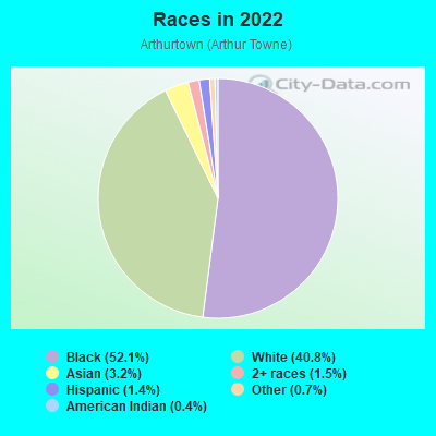
- 3,65752.1%Black
- 2,86340.8%White
- 2273.2%Asian
- 1041.5%Two or more races
- 951.4%Hispanic or Latino
- 500.7%Some other race
- 280.4%American Indian
Distribution of median household income
![Distribution of median household income]()
- 542Less than $10,000
- 313$10,000 to $19,999
- 406$20,000 to $29,999
- 310$30,000 to $39,999
- 216$40,000 to $49,999
- 276$50,000 to $59,999
- 148$60,000 to $74,999
- 197$75,000 to $99,999
- 219$100,000 to $124,999
- 128$125,000 to $149,999
- 34$150,000 to $199,999
- 42$200,000 or more

Distribution of owner-occupied house/condo value
![Distribution of owner-occupied house/condo value]()
- 1,241Less than $50,000
- 453$50,000 to $99,999
- 266$100,000 to $149,999
- 252$150,000 to $199,999
- 49$200,000 to $249,999
- 76$250,000 to $299,999
- 43$300,000 to $399,999
- 34$400,000 to $499,999
- 918$500,000 to $749,999
- 151$750,000 to $999,999
- 1,185$1,000,000 or more

Distribution of rent paid by renters
![Distribution of rent paid by renters]()
- 364Less than $100
- 11$100 to $199
- 262$200 to $299
- 124$300 to $399
- 409$400 to $499
- 456$500 to $599
- 456$600 to $699
- 551$700 to $799
- 393$800 to $899
- 243$900 to $999
- 84$1,000 to $1,249
- 66$1,250 to $1,499
- 175$1,500 to $1,999
- 839$2,000 or more

Median rent in 2022:
| Arthurtown (Arthur Towne): | $787 |
| Columbia: | $975 |
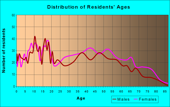
| Males: | 4,114 |
| Females: | 2,746 |
Males:
| This neighborhood: | 32.4 years |
| Whole city: | 27.5 years |
| This neighborhood: | 40.0 years |
| Whole city: | 29.3 years |
Average household size:
| Arthurtown (Arthur Towne): | 7.2 people |
| Columbia: | 2.1 people |
Percentage of family households:
| Arthurtown (Arthur Towne): | 18.1% |
| Columbia: | 35.2% |
| Here: | 14.7% |
| Columbia: | 27.5% |
Percentage of married-couple families with children (among all households):
| Arthurtown (Arthur Towne): | 11.7% |
| Columbia: | 23.7% |
Percentage of single-mother households (among all households):
| Arthurtown (Arthur Towne): | 58.5% |
| Columbia: | 12.1% |
Percentage of never married males 15 years old and over:
Percentage of never married females 15 years old and over:
| Arthurtown (Arthur Towne): | 50.1% |
| Columbia: | 31.8% |
Percentage of never married females 15 years old and over:
| Arthurtown (Arthur Towne): | 25.1% |
| city: | 26.3% |
Percentage of people that speak English not well or not at all:
| Arthurtown (Arthur Towne): | 0.0% |
| Columbia: | 0.6% |
Percentage of people born in this state:
Percentage of people born in another U.S. state:
Percentage of native residents but born outside the U.S.:
Percentage of foreign born residents:
| Here: | 66.7% |
| Columbia: | 53.1% |
Percentage of people born in another U.S. state:
| Arthurtown (Arthur Towne): | 28.6% |
| Columbia: | 40.1% |
Percentage of native residents but born outside the U.S.:
| Here: | 1.8% |
| city: | 2.2% |
Percentage of foreign born residents:
| Here: | 3.5% |
| Columbia: | 4.6% |
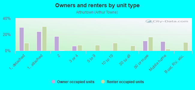
Owner-occupied
Renter-occupied

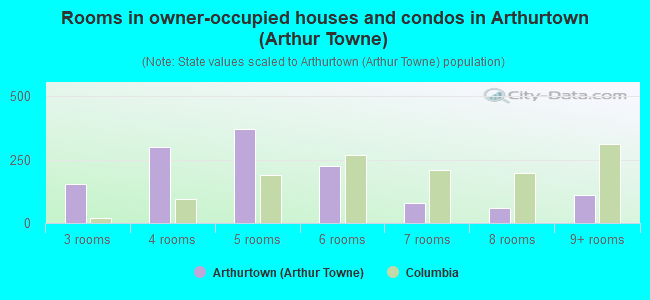
- Rooms in owner-occupied houses and condos in Arthurtown <
> - 01 room
- 02 rooms
- 1543 rooms
- 3004 rooms
- 3715 rooms
- 2266 rooms
- 797 rooms
- 588 rooms
- 1109+ rooms
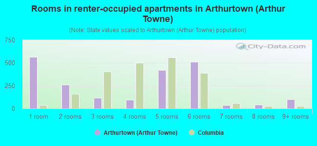
- Rooms in renter-occupied apartments in Arthurtown <
> - 5651 room
- 2612 rooms
- 1173 rooms
- 944 rooms
- 4215 rooms
- 5096 rooms
- 397 rooms
- 418 rooms
- 1039+ rooms
Owner-occupied
Renter-occupied
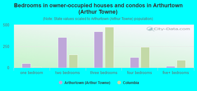
- Bedrooms in owner-occupied houses and condos in Arthurtown <
> - 0no bedroom
- 491 bedroom
- 3552 bedrooms
- 4233 bedrooms
- 1204 bedrooms
- 195+ bedrooms
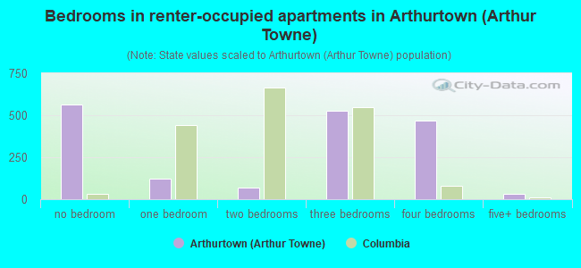
- Bedrooms in renter-occupied apartments in Arthurtown <
> - 565no bedroom
- 1221 bedroom
- 672 bedrooms
- 5263 bedrooms
- 4694 bedrooms
- 325+ bedrooms
Average number of cars or other vehicles available in houses/condos:
Average number of cars or other vehicles available in apartments:
| This neighborhood: | 1.5 |
| Columbia: | 1.8 |
Average number of cars or other vehicles available in apartments:
| Here: | 2.3 |
| city: | 1.3 |
Percentage of units with a mortgage:
| Arthurtown (Arthur Towne): | 44.4% |
| Columbia: | 67.5% |
Average estimated value of detached houses in 2022 (32.2% of all units):
| Arthurtown (Arthur Towne): | $120,936 |
| Columbia: | $305,357 |
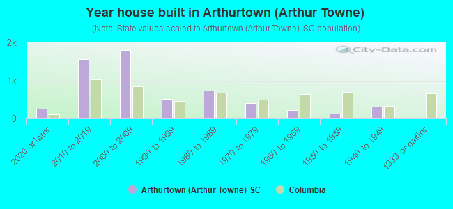
- Year house built in Arthurtown <
> - 2522020 or later
- 1,5672010 to 2019
- 1,7992000 to 2009
- 5071990 to 1999
- 7381980 to 1989
- 4021970 to 1979
- 2121960 to 1969
- 1331950 to 1959
- 3171940 to 1949
- 251939 or earlier
City-data.com crime index for city in 2020 (higher means more crime):
| City: | 446.0 |
| U.S. average: | 219.5 |
Travel time to work (commute)
![Travel time to work (commute)]()
- 47Less than 5 minutes
- 1515 to 9 minutes
- 20410 to 14 minutes
- 68815 to 19 minutes
- 51320 to 24 minutes
- 29125 to 29 minutes
- 50630 to 34 minutes
- 9535 to 39 minutes
- 1740 to 44 minutes
- 39345 to 59 minutes
- 4360 to 89 minutes
- 39290 or more minutes

Means of transportation to work
![Means of transportation to work]()
- 80.9%2,500Drove a car alone
- 11.8%364Carpooled
- 3.1%95Bus
- 5.5%170Motorcycle
- 10.9%338Bicycle
- 0.9%27Walked
- 3.8%118Other means
- 5.2%160Worked at home

Time leaving home to go to work
![Time leaving home to go to work]()
- 19612:00 a.m. to 4:59 a.m.
- 3115:00 a.m. to 5:29 a.m.
- 1515:30 a.m. to 5:59 a.m.
- 706:00 a.m. to 6:29 a.m.
- 2866:30 a.m. to 6:59 a.m.
- 2747:00 a.m. to 7:29 a.m.
- 2927:30 a.m. to 7:59 a.m.
- 1878:00 a.m. to 8:29 a.m.
- 298:30 a.m. to 8:59 a.m.
- 1059:00 a.m. to 9:59 a.m.
- 24610:00 a.m. to 10:59 a.m.
- 4511:00 a.m. to 11:59 a.m.
- 57012:00 p.m. to 3:59 p.m.
- 3914:00 p.m. to 11:59 p.m.

Occupations of males:
- Percentage of males in management occupations (except farmers):
Here: 7.2% city: 12.3%
- Percentage of males in business and financial operations occupations:
Here: 3.0% city: 4.6%
- Percentage of males in computer and mathematical occupations:
Here: 2.8% city: 3.7%
- Percentage of males in education, training, and library occupations:
Here: 5.8% city: 6.7%
- Percentage of males in healthcare practitioners and technical occupations:
Here: 8.8% city: 4.6%
- Percentage of males in service occupations:
Here: 27.1% city: 18.4%
- Percentage of males in sales and office occupations:
Here: 11.8% city: 16.6%
- Percentage of males in farming, fishing, and forestry occupations:
Here: 4.6% city: 0.7%
- Percentage of males in construction, extraction, and maintenance occupations:
Here: 6.5% city: 4.8%
- Percentage of males in production occupations:
Here: 2.0% city: 3.9%
- Percentage of males in transportation occupations:
Here: 3.7% city: 4.1%
- Percentage of males in material moving occupations:
Here: 6.2% city: 5.8%
Occupations of females:
- Percentage of females in community and social services occupations:
Here: 1.1% city: 2.6%
- Percentage of females in education, training, and library occupations:
Here: 4.0% city: 11.5%
- Percentage of females in healthcare practitioners and technical occupations:
Here: 19.4% city: 8.7%
- Percentage of females in service occupations:
Here: 34.7% city: 20.2%
- Percentage of females in sales and office occupations:
Here: 32.6% city: 26.9%
- Percentage of females in production occupations:
Here: 7.4% city: 3.3%
Percentage of people 16-64 in Armed Forces:
| Arthurtown (Arthur Towne): | 0.0% |
| Columbia: | 7.2% |
Education in this neighborhood (subdivision or community):
- Percentage of people 3 years and older in K-12 schools:
Arthurtown (Arthur Towne): 25.5% Columbia: 12.2%
- Percentage of people 3 years and older in undergraduate colleges:
Arthurtown (Arthur Towne): 39.2% Columbia: 16.2%
- Percentage of people 3 years and older in grad. or professional schools:
Arthurtown (Arthur Towne): 7.7% Columbia: 3.5%
- Percentage of students K-12 enrolled in private schools:
Arthurtown (Arthur Towne): 85.7% Columbia: 24.2%
Percentage of population below poverty level:
| Arthurtown (Arthur Towne): | 49.9% |
| Columbia: | 20.7% |
Median year owner moved in (as recorded in 2022):
| Arthurtown (Arthur Towne): | 2004 |
| Columbia: | 2013 |
Percentage of married-couple families with both working:
| Arthurtown (Arthur Towne): | 304.1% |
| Columbia: | 72.3% |
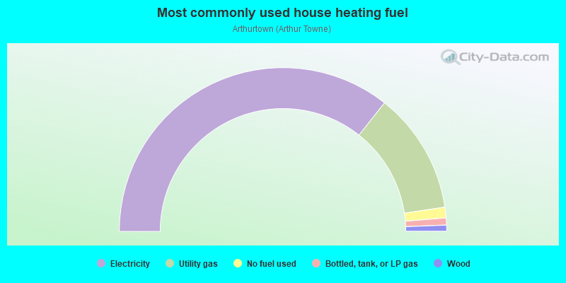
- 71.3%Electricity
- 24.0%Utility gas
- 2.1%No fuel used
- 1.4%Bottled, tank, or LP gas
- 1.2%Wood
Limited-access highways (interstate or state) in this neighborhood:
I- 77 (I- 326)
Length: 4.75 miles
Directions: E-W, SE-NW, SW-NE
Directions: E-W, SE-NW, SW-NE
Highways in this neighborhood:
State Hwy 768 (Pineview Rd)
Length: 0.45 miles
Directions: E-W, SW-NE
Address range: 1500 to 1799
Directions: E-W, SW-NE
Address range: 1500 to 1799
Roads and streets:
Bluff Rd
Length: 7.02 miles
Directions: E-W, N-S, SE-NW, SW-NE
Address range: 1701 to 4855
Directions: E-W, N-S, SE-NW, SW-NE
Address range: 1701 to 4855
Shop Rd
Length: 6.40 miles
Directions: E-W, SE-NW, SW-NE
Address range: 1000 to 2899
Directions: E-W, SE-NW, SW-NE
Address range: 1000 to 2899
State Rd S-40-51 (Whitehouse Rd)
Length: 2.33 miles
Directions: E-W, N-S, SE-NW, SW-NE
Address range: 750 to 1357
Directions: E-W, N-S, SE-NW, SW-NE
Address range: 750 to 1357
Andrews Rd
Length: 2.32 miles
Directions: E-W, N-S, SE-NW, SW-NE
Address range: 800 to 9001
Directions: E-W, N-S, SE-NW, SW-NE
Address range: 800 to 9001
Atlas Rd
Length: 2.00 miles
Direction: SW-NE
Address range: 1400 to 2815
Direction: SW-NE
Address range: 1400 to 2815
Harlem St
Length: 1.68 miles
Directions: N-S, SE-NW, SW-NE
Address range: 1700 to 2799
Directions: N-S, SE-NW, SW-NE
Address range: 1700 to 2799
S Beltline Blvd (S-40-538)
Length: 1.64 miles
Directions: E-W, N-S, SE-NW, SW-NE
Address range: 2000 to 5099
Directions: E-W, N-S, SE-NW, SW-NE
Address range: 2000 to 5099
Richard St
Length: 1.35 miles
Directions: E-W, N-S, SE-NW, SW-NE
Address range: 7500 to 8299
Directions: E-W, N-S, SE-NW, SW-NE
Address range: 7500 to 8299
Key Rd
Length: 1.28 miles
Directions: E-W, SE-NW, SW-NE
Address range: 1000 to 1601
Directions: E-W, SE-NW, SW-NE
Address range: 1000 to 1601
Rosewood Dr
Length: 1.24 miles
Directions: E-W, SW-NE
Address range: 600 to 1319
Directions: E-W, SW-NE
Address range: 600 to 1319
Zion Ave
Length: 1.14 miles
Directions: N-S, SE-NW, SW-NE
Address range: 1600 to 1999
Directions: N-S, SE-NW, SW-NE
Address range: 1600 to 1999
Pineview Dr
Length: 1.12 miles
Direction: SW-NE
Address range: 1000 to 1499
Direction: SW-NE
Address range: 1000 to 1499
Shop Rd Exd (Sc-768)
Length: 1.05 miles
Directions: E-W, SE-NW, SW-NE
Directions: E-W, SE-NW, SW-NE
I-77
Length: 0.99 miles
Direction: E-W
Direction: E-W
George Rogers Blvd
Length: 0.97 miles
Directions: N-S, SE-NW, SW-NE
Address range: 900 to 1199
Directions: N-S, SE-NW, SW-NE
Address range: 900 to 1199
Joe Frazier Ct
Length: 0.90 miles
Directions: N-S, SE-NW, SW-NE
Address range: 1900 to 2499
Directions: N-S, SE-NW, SW-NE
Address range: 1900 to 2499
Candlelite Dr
Length: 0.86 miles
Directions: E-W, N-S, SE-NW, SW-NE
Address range: 3900 to 4399
Directions: E-W, N-S, SE-NW, SW-NE
Address range: 3900 to 4399
Beckman Swamp Rd
Length: 0.70 miles
Directions: N-S, SW-NE
Directions: N-S, SW-NE
Idlewild Blvd
Length: 0.64 miles
Direction: SW-NE
Address range: 900 to 1199
Direction: SW-NE
Address range: 900 to 1199
The Boulevard
Length: 0.63 miles
Directions: E-W, SE-NW, SW-NE
Address range: 2600 to 2899
Directions: E-W, SE-NW, SW-NE
Address range: 2600 to 2899
Palmland Dr
Length: 0.61 miles
Directions: E-W, N-S, SW-NE
Address range: 2500 to 2648
Directions: E-W, N-S, SW-NE
Address range: 2500 to 2648
Abbott Rd
Length: 0.59 miles
Direction: SW-NE
Address range: 900 to 1299
Direction: SW-NE
Address range: 900 to 1299
State Rd S-40-585
Length: 0.57 miles
Direction: SW-NE
Direction: SW-NE
Barnes St
Length: 0.57 miles
Directions: E-W, N-S, SE-NW, SW-NE
Address range: 500 to 819
Directions: E-W, N-S, SE-NW, SW-NE
Address range: 500 to 819
Mauney St
Length: 0.56 miles
Direction: SW-NE
Address range: 700 to 799
Direction: SW-NE
Address range: 700 to 799
Smith St
Length: 0.56 miles
Directions: E-W, SE-NW, SW-NE
Address range: 1712 to 2050
Directions: E-W, SE-NW, SW-NE
Address range: 1712 to 2050
Childs St
Length: 0.54 miles
Directions: E-W, N-S, SE-NW, SW-NE
Address range: 500 to 830
Directions: E-W, N-S, SE-NW, SW-NE
Address range: 500 to 830
Windy Dr
Length: 0.53 miles
Direction: SW-NE
Address range: 2400 to 2706
Direction: SW-NE
Address range: 2400 to 2706
Old Dairy Dr
Length: 0.51 miles
Direction: E-W
Address range: 1300 to 1414
Direction: E-W
Address range: 1300 to 1414
Eastway Dr
Length: 0.51 miles
Directions: N-S, SW-NE
Address range: 2900 to 3099
Directions: N-S, SW-NE
Address range: 2900 to 3099
Reeder Point Dr
Length: 0.51 miles
Directions: E-W, SW-NE
Address range: 1 to 99
Directions: E-W, SW-NE
Address range: 1 to 99
Riley St
Length: 0.50 miles
Directions: E-W, N-S, SW-NE
Address range: 427 to 699
Directions: E-W, N-S, SW-NE
Address range: 427 to 699
Blair Rd
Length: 0.50 miles
Directions: E-W, SW-NE
Address range: 900 to 1199
Directions: E-W, SW-NE
Address range: 900 to 1199
Sugar Hill Ln
Length: 0.48 miles
Directions: E-W, SW-NE
Address range: 500 to 899
Directions: E-W, SW-NE
Address range: 500 to 899
The Blvd
Length: 0.45 miles
Direction: SW-NE
Direction: SW-NE
Brookwood Dr
Length: 0.44 miles
Directions: E-W, SW-NE
Address range: 800 to 999
Directions: E-W, SW-NE
Address range: 800 to 999
Shorecrest Dr
Length: 0.44 miles
Directions: E-W, SW-NE
Address range: 4100 to 4344
Directions: E-W, SW-NE
Address range: 4100 to 4344
Bates St
Length: 0.44 miles
Direction: SW-NE
Address range: 904 to 1199
Direction: SW-NE
Address range: 904 to 1199
Veterans Rd
Length: 0.44 miles
Directions: N-S, SE-NW
Address range: 1200 to 1399
Directions: N-S, SE-NW
Address range: 1200 to 1399
Frasier St
Length: 0.43 miles
Directions: N-S, SE-NW, SW-NE
Address range: 727 to 1099
Directions: N-S, SE-NW, SW-NE
Address range: 727 to 1099
Northeast Fwy
Length: 0.42 miles
Direction: SE-NW
Direction: SE-NW
Walcott St
Length: 0.42 miles
Directions: E-W, SW-NE
Address range: 1000 to 1299
Directions: E-W, SW-NE
Address range: 1000 to 1299
1st St S
Length: 0.41 miles
Direction: SW-NE
Direction: SW-NE
Hileah Dr
Length: 0.41 miles
Directions: E-W, N-S, SE-NW, SW-NE
Address range: 4100 to 4251
Directions: E-W, N-S, SE-NW, SW-NE
Address range: 4100 to 4251
Humane Ln
Length: 0.41 miles
Directions: E-W, N-S, SE-NW, SW-NE
Address range: 100 to 199
Directions: E-W, N-S, SE-NW, SW-NE
Address range: 100 to 199
Blaine St
Length: 0.39 miles
Direction: SW-NE
Address range: 1300 to 1699
Direction: SW-NE
Address range: 1300 to 1699
S Stadium Rd
Length: 0.37 miles
Direction: SW-NE
Address range: 900 to 999
Direction: SW-NE
Address range: 900 to 999
Winfield Rd
Length: 0.36 miles
Directions: N-S, SE-NW, SW-NE
Address range: 1400 to 1799
Directions: N-S, SE-NW, SW-NE
Address range: 1400 to 1799
Robney Dr
Length: 0.35 miles
Directions: E-W, SE-NW
Address range: 4500 to 4699
Directions: E-W, SE-NW
Address range: 4500 to 4699
Atlas Way
Length: 0.35 miles
Direction: SE-NW
Address range: 1000 to 1599
Direction: SE-NW
Address range: 1000 to 1599
S-40-1308 (A St)
Length: 0.33 miles
Directions: E-W, N-S, SE-NW, SW-NE
Address range: 1 to 9999
Directions: E-W, N-S, SE-NW, SW-NE
Address range: 1 to 9999
Winter Park Dr
Length: 0.32 miles
Directions: E-W, SE-NW
Address range: 4000 to 4142
Directions: E-W, SE-NW
Address range: 4000 to 4142
N Shorecrest Dr
Length: 0.32 miles
Direction: SW-NE
Address range: 1 to 199
Direction: SW-NE
Address range: 1 to 199
Garland St
Length: 0.32 miles
Directions: E-W, N-S, SE-NW
Address range: 700 to 905
Directions: E-W, N-S, SE-NW
Address range: 700 to 905
National Guard Rd
Length: 0.31 miles
Direction: SW-NE
Address range: 1 to 99
Direction: SW-NE
Address range: 1 to 99
Eden St
Length: 0.30 miles
Directions: N-S, SE-NW, SW-NE
Address range: 1200 to 1299
Directions: N-S, SE-NW, SW-NE
Address range: 1200 to 1299
Dunston St
Length: 0.30 miles
Directions: N-S, SW-NE
Address range: 1300 to 1526
Directions: N-S, SW-NE
Address range: 1300 to 1526
Mauney Ct
Length: 0.29 miles
Directions: N-S, SE-NW, SW-NE
Address range: 1 to 99
Directions: N-S, SE-NW, SW-NE
Address range: 1 to 99
Market Rd
Length: 0.29 miles
Directions: SE-NW, SW-NE
Address range: 1000 to 1099
Directions: SE-NW, SW-NE
Address range: 1000 to 1099
Joe Louis Dr
Length: 0.29 miles
Directions: N-S, SE-NW, SW-NE
Address range: 1000 to 1199
Directions: N-S, SE-NW, SW-NE
Address range: 1000 to 1199
Camino Ct
Length: 0.29 miles
Directions: E-W, N-S, SE-NW
Address range: 4200 to 4399
Directions: E-W, N-S, SE-NW
Address range: 4200 to 4399
Sparkman Dr
Length: 0.29 miles
Directions: E-W, SE-NW, SW-NE
Address range: 100 to 199
Directions: E-W, SE-NW, SW-NE
Address range: 100 to 199
Dell Dr
Length: 0.29 miles
Directions: N-S, SW-NE
Address range: 2900 to 3022
Directions: N-S, SW-NE
Address range: 2900 to 3022
Bluff Industrial Blvd
Length: 0.29 miles
Direction: SW-NE
Address range: 1115 to 1199
Direction: SW-NE
Address range: 1115 to 1199
Burdock Cir (S-40-2314)
Length: 0.28 miles
Directions: E-W, N-S, SE-NW, SW-NE
Address range: 1 to 116
Directions: E-W, N-S, SE-NW, SW-NE
Address range: 1 to 116
Tavineer Dr
Length: 0.27 miles
Directions: E-W, N-S, SE-NW
Address range: 4000 to 4199
Directions: E-W, N-S, SE-NW
Address range: 4000 to 4199
Surfwood Dr
Length: 0.27 miles
Direction: SE-NW
Address range: 4300 to 4399
Direction: SE-NW
Address range: 4300 to 4399
Corbett St
Length: 0.27 miles
Directions: E-W, SE-NW
Address range: 4500 to 4699
Directions: E-W, SE-NW
Address range: 4500 to 4699
2nd Ave
Length: 0.26 miles
Directions: SE-NW, SW-NE
Address range: 1000 to 1099
Directions: SE-NW, SW-NE
Address range: 1000 to 1099
Crestlite Dr
Length: 0.26 miles
Direction: SE-NW
Address range: 4300 to 4375
Direction: SE-NW
Address range: 4300 to 4375
Bombay Dr
Length: 0.26 miles
Direction: SW-NE
Address range: 1 to 299
Direction: SW-NE
Address range: 1 to 299
Aster St
Length: 0.26 miles
Directions: N-S, SE-NW, SW-NE
Address range: 1 to 221
Directions: N-S, SE-NW, SW-NE
Address range: 1 to 221
la Clair Dr
Length: 0.26 miles
Direction: SE-NW
Address range: 4300 to 4367
Direction: SE-NW
Address range: 4300 to 4367
Mellowood Dr
Length: 0.25 miles
Direction: SE-NW
Address range: 4300 to 4370
Direction: SE-NW
Address range: 4300 to 4370
Flamingo Dr
Length: 0.25 miles
Direction: SW-NE
Address range: 2500 to 2647
Direction: SW-NE
Address range: 2500 to 2647
Hemlock Rd
Length: 0.25 miles
Directions: SE-NW, SW-NE
Address range: 900 to 999
Directions: SE-NW, SW-NE
Address range: 900 to 999
Charter Ct
Length: 0.25 miles
Directions: E-W, N-S, SE-NW, SW-NE
Address range: 4297 to 4366
Directions: E-W, N-S, SE-NW, SW-NE
Address range: 4297 to 4366
Silo Ct
Length: 0.24 miles
Directions: E-W, SE-NW
Directions: E-W, SE-NW
Levintis Rd
Length: 0.24 miles
Direction: SW-NE
Address range: 100 to 199
Direction: SW-NE
Address range: 100 to 199
Sands St
Length: 0.24 miles
Direction: SW-NE
Address range: 1200 to 1299
Direction: SW-NE
Address range: 1200 to 1299
Berea Rd
Length: 0.24 miles
Direction: SW-NE
Address range: 1000 to 1199
Direction: SW-NE
Address range: 1000 to 1199
Metal Park Dr
Length: 0.24 miles
Directions: E-W, N-S, SE-NW
Address range: 100 to 199
Directions: E-W, N-S, SE-NW
Address range: 100 to 199
Aster Cir
Length: 0.23 miles
Directions: E-W, N-S, SE-NW, SW-NE
Address range: 80 to 315
Directions: E-W, N-S, SE-NW, SW-NE
Address range: 80 to 315
Medlin St
Length: 0.22 miles
Directions: E-W, SE-NW, SW-NE
Address range: 150 to 199
Directions: E-W, SE-NW, SW-NE
Address range: 150 to 199
Branning Dr
Length: 0.22 miles
Direction: SE-NW
Direction: SE-NW
1st Ave
Length: 0.21 miles
Direction: SE-NW
Address range: 1000 to 1099
Direction: SE-NW
Address range: 1000 to 1099
Avalon Dr
Length: 0.20 miles
Direction: SW-NE
Address range: 2700 to 2799
Direction: SW-NE
Address range: 2700 to 2799
Whitlock St
Length: 0.20 miles
Directions: E-W, SE-NW
Address range: 100 to 199
Directions: E-W, SE-NW
Address range: 100 to 199
Metro Ln (S-40-537)
Length: 0.20 miles
Direction: SE-NW
Direction: SE-NW
Sheraton Rd
Length: 0.20 miles
Directions: E-W, SE-NW
Address range: 4500 to 4699
Directions: E-W, SE-NW
Address range: 4500 to 4699
Vine St
Length: 0.20 miles
Directions: E-W, SE-NW
Address range: 700 to 899
Directions: E-W, SE-NW
Address range: 700 to 899
Tolliver St
Length: 0.19 miles
Directions: N-S, SW-NE
Address range: 1200 to 1299
Directions: N-S, SW-NE
Address range: 1200 to 1299
Duval St
Length: 0.19 miles
Direction: SE-NW
Address range: 700 to 899
Direction: SE-NW
Address range: 700 to 899
Oakdale St
Length: 0.18 miles
Direction: SE-NW
Address range: 700 to 899
Direction: SE-NW
Address range: 700 to 899
Dumont St
Length: 0.18 miles
Directions: N-S, SE-NW
Address range: 1 to 99
Directions: N-S, SE-NW
Address range: 1 to 99
Barlow Rd
Length: 0.18 miles
Direction: SW-NE
Direction: SW-NE
Northway Rd
Length: 0.17 miles
Direction: SW-NE
Address range: 100 to 199
Direction: SW-NE
Address range: 100 to 199
Basil Rd
Length: 0.16 miles
Direction: SW-NE
Address range: 1300 to 1499
Direction: SW-NE
Address range: 1300 to 1499
First St S
Length: 0.15 miles
Directions: E-W, SW-NE
Directions: E-W, SW-NE
Ramona St
Length: 0.15 miles
Direction: E-W
Address range: 7700 to 7913
Direction: E-W
Address range: 7700 to 7913
S Cutter's
Length: 0.15 miles
Directions: N-S, SW-NE
Directions: N-S, SW-NE
N Shorecrest Rd
Length: 0.15 miles
Directions: E-W, SW-NE
Directions: E-W, SW-NE
Going St
Length: 0.14 miles
Directions: SE-NW, SW-NE
Address range: 1000 to 1099
Directions: SE-NW, SW-NE
Address range: 1000 to 1099
Commerce Blvd
Length: 0.14 miles
Direction: SW-NE
Direction: SW-NE
Pasture Ln
Length: 0.13 miles
Direction: SW-NE
Address range: 1100 to 1199
Direction: SW-NE
Address range: 1100 to 1199
Acme St
Length: 0.13 miles
Directions: E-W, SE-NW
Address range: 2 to 99
Directions: E-W, SE-NW
Address range: 2 to 99
Wactor St
Length: 0.13 miles
Directions: E-W, SE-NW
Address range: 4500 to 4599
Directions: E-W, SE-NW
Address range: 4500 to 4599
Blaylock Rd
Length: 0.12 miles
Directions: N-S, SW-NE
Directions: N-S, SW-NE
Ehrlich St
Length: 0.10 miles
Direction: SW-NE
Address range: 1200 to 1299
Direction: SW-NE
Address range: 1200 to 1299
Simmons St
Length: 0.10 miles
Direction: SW-NE
Address range: 800 to 999
Direction: SW-NE
Address range: 800 to 999
Blakely Rd
Length: 0.09 miles
Direction: SW-NE
Address range: 100 to 199
Direction: SW-NE
Address range: 100 to 199
Brogdon St
Length: 0.09 miles
Directions: N-S, SW-NE
Address range: 5100 to 5199
Directions: N-S, SW-NE
Address range: 5100 to 5199
Bible Way
Length: 0.09 miles
Direction: SE-NW
Direction: SE-NW
Mary St
Length: 0.09 miles
Direction: SE-NW
Address range: 200 to 299
Direction: SE-NW
Address range: 200 to 299
Bill St
Length: 0.08 miles
Direction: SE-NW
Address range: 300 to 399
Direction: SE-NW
Address range: 300 to 399
Marathon Dr
Length: 0.08 miles
Direction: SW-NE
Address range: 2500 to 2522
Direction: SW-NE
Address range: 2500 to 2522
Frazier St
Length: 0.08 miles
Directions: E-W, SE-NW
Address range: 725 to 813
Directions: E-W, SE-NW
Address range: 725 to 813
Old Dairy Rd
Length: 0.07 miles
Direction: E-W
Direction: E-W
S-40-2356
Length: 0.06 miles
Direction: SE-NW
Direction: SE-NW
Hattie Gibson Rd
Length: 0.06 miles
Direction: SE-NW
Address range: 1800 to 1899
Direction: SE-NW
Address range: 1800 to 1899
Mickens Rd
Length: 0.04 miles
Direction: SW-NE
Direction: SW-NE
Robney Ct
Length: 0.03 miles
Direction: SW-NE
Address range: 4600 to 4699
Direction: SW-NE
Address range: 4600 to 4699
First Ave (S-40-1309)
Length: 0.02 miles
Direction: SE-NW
Direction: SE-NW
Merch Ct
Length: 0.02 miles
Direction: SE-NW
Address range: 1 to 12
Direction: SE-NW
Address range: 1 to 12
Riley Ct
Length: 0.02 miles
Direction: SE-NW
Address range: 1 to 99
Direction: SE-NW
Address range: 1 to 99
S-40-48 (Broad River Rd)
Length: 0.02 miles
Direction: E-W
Direction: E-W
Railroad features:
Southern Rlwy
Length: 9.75 miles
Directions: E-W, N-S, SE-NW, SW-NE
Directions: E-W, N-S, SE-NW, SW-NE
Csx RR
Length: 7.17 miles
Directions: E-W, N-S, SE-NW, SW-NE
Directions: E-W, N-S, SE-NW, SW-NE
Other features:
Gills Crk
Length: 7.95 miles
Directions: E-W, N-S, SE-NW, SW-NE
Directions: E-W, N-S, SE-NW, SW-NE
Reeder Point Br
Length: 0.72 miles
Directions: E-W, N-S, SW-NE
Directions: E-W, N-S, SW-NE
Black Lk
Length: 0.55 miles
Directions: E-W, N-S, SE-NW, SW-NE
Directions: E-W, N-S, SE-NW, SW-NE