Submit your own pictures of this town and show them to the world
Percentage of residents living in poverty in 2022: 9.7%
(8.8% for White Non-Hispanic residents, 33.3% for Hispanic or Latino residents, 12.8% for American Indian residents, 10.0% for two or more races residents)
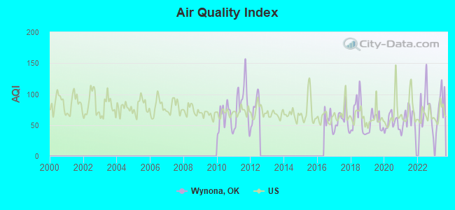
Air Quality Index (AQI) level in 2023 was 82.4. This is about average.
City:
82.4
U.S.:
72.6
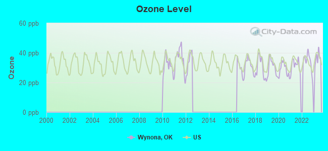
Ozone [ppb] level in 2023 was 35.9. This is about average.Closest monitor was 0.2 miles away from the city center.
City:
35.9
U.S.:
33.3
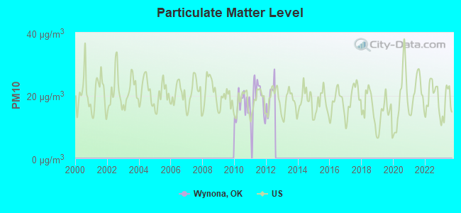
Particulate Matter (PM10) [µg/m3] level in 2012 was 20.0. This is about average.Closest monitor was 8.7 miles away from the city center.
City:
20.0
U.S.:
19.2
Tornado activity:
Wynona-area historical tornado activity is near Oklahoma state average. It is 151% greater than the overall U.S. average.
On 4/26/1991, a category F4 (max. wind speeds 207-260 mph) tornado 12.7 miles away from the Wynona town center injured 6 peopleand causedbetween $500,000 and $5,000,000 in damages.
On 6/8/1974, a category F4 tornado 16.7 miles away from the town center killed 14 peopleand injured 150 peopleand causedbetween $500,000 and $5,000,000 in damages.
Earthquake activity:
Wynona-area historical earthquake activity is significantly above Oklahoma state average. It is 843% greater than the overall U.S. average.
On 9/3/2016 at 12:02:44, a magnitude 5.8 (5.8 MW, Depth: 3.5 mi, Class: Moderate, Intensity: VI - VII) earthquake occurred 34.6 miles away from the city center On 11/6/2011 at 03:53:10, a magnitude 5.7 (5.7 MW, Depth: 3.2 mi) earthquake occurred 74.3 miles away from Wynona center On 11/7/2016 at 01:44:24, a magnitude 5.0 (5.0 MW, Depth: 2.8 mi) earthquake occurred 46.7 miles away from the city center On 11/12/2014 at 21:40:00, a magnitude 4.9 (4.9 MW, Depth: 2.5 mi, Class: Light, Intensity: IV - V) earthquake occurred 87.4 miles away from the city center On 2/13/2016 at 17:07:06, a magnitude 5.1 (5.1 MW, Depth: 5.2 mi) earthquake occurred 132.5 miles away from the city center On 11/5/2011 at 07:12:45, a magnitude 4.8 (4.8 MW, Depth: 1.9 mi) earthquake occurred 73.1 miles away from the city center Magnitude types: moment magnitude (MW)
Natural disasters:
The number of natural disasters in Osage County (35) is a lot greater than the US average (15). Major Disasters (Presidential) Declared: 25 Emergencies Declared: 5
Causes of natural disasters: Floods: 16, Storms: 16, Tornadoes: 11, Winter Storms: 10, Winds: 4, Fires: 3, Heavy Rains: 2, Ice Storms: 2, Hurricane: 1, Snowstorm: 1, Other: 1 (Note: some incidents may be assigned to more than one category).
Hospitals and medical centers near Wynona:
OSAGE HOME HEALTH (Home Health Center, about 9 miles away; PAWHUSKA, OK)
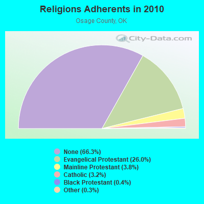
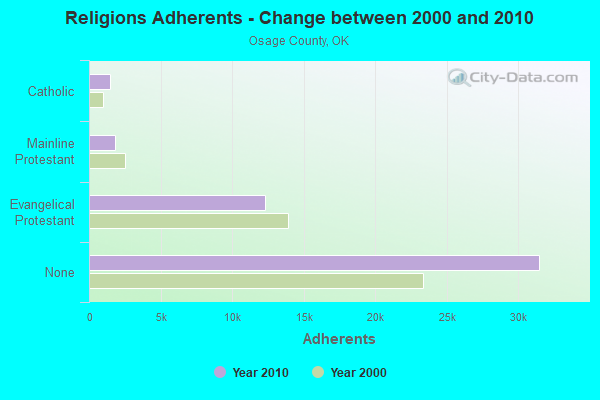
Religion statistics for Wynona, OK (based on Osage County data)
Religion
Adherents
Congregations
Evangelical Protestant
12,337
54
Mainline Protestant
1,783
15
Catholic
1,500
7
Black Protestant
209
2
Other
150
2
None
31,493
-
Source: Clifford Grammich, Kirk Hadaway, Richard Houseal, Dale E.Jones, Alexei Krindatch, Richie Stanley and Richard H.Taylor. 2012. 2010 U.S.Religion Census: Religious Congregations & Membership Study. Association of Statisticians of American Religious Bodies. Jones, Dale E., et al. 2002. Congregations and Membership in the United States 2000. Nashville, TN: Glenmary Research Center. Graphs represent county-level data
6.4 Km Nw (Lat: 36.613389 Lon: -96.416139), Type: Tower, Structure height: 86 m, Call Sign: WPLQ849, Assigned Frequencies: 157.740 MHz, Grant Date: 12/04/1997, Expiration Date: 12/04/2007, Cancellation Date: 04/08/2002, Certifier: David Higginbotham, Registrant: Blooston, Mordkofsky, Dickens, Duffy & Prendergast, 2120 L Street, N.W., Suite 300, Washington, DC 20037, Phone: (202) 659-0830, Fax: (202) 828-5568
FCC Registered Broadcast Land Mobile Towers:
2
2.1 Miles Ssw Of The City Of (Lat: 36.518056 Lon: -96.342222), Type: Tower, Structure height: 10 m, Overall height: 10.7 m, Call Sign: WPBZ383, Assigned Frequencies: 169.425 MHz, Grant Date: 01/10/2023, Expiration Date: 04/07/2033, Registrant: Oklahoma Climatological Survey, 120 David L. Boren Blvd, ; Suite 2900, Norman, OK 73072, Phone: (405) 325-2541, Fax: (405) 325-7282, Email:
Wynona, 4596 County Rd. 5770 (Lat: 36.597361 Lon: -96.392806), Type: Gtower, Structure height: 143.6 m, Call Sign: WPCM984, Licensee ID: L00268142, Assigned Frequencies: 855.012 MHz, 855.812 MHz, 856.812 MHz, 857.812 MHz, 859.337 MHz, Grant Date: 04/07/2023, Expiration Date: 06/21/2033, Registrant: American Electric Power Service Corporation
FCC Registered Microwave Towers:
3
Wynona, 7147 County Road 2350 (Lat: 36.532528 Lon: -96.325556), Type: Gtower, Structure height: 91.4 m, Overall height: 92.7 m, Call Sign: WQSY301, Assigned Frequencies: 11265.0 MHz, 11345.0 MHz, Grant Date: 11/07/2023, Expiration Date: 12/09/2033, Certifier: John E Monday, Registrant: At&t Services, Inc., 208 S Akard St, 20f, Dallas, TX 75202, Phone: (855) 699-7073, Email:
WYNONA, County Road 5045 (Lat: 36.519889 Lon: -96.345528), Type: Ltower, Structure height: 73.2 m, Overall height: 76.2 m, Call Sign: WQZD478, Assigned Frequencies: 6256.54 MHz, Grant Date: 04/12/2017, Expiration Date: 04/12/2027, Certifier: Steven T Campbell, Registrant: Wilkinson Barker Knauer, LLP, 1800 M Street Nw, Suite 800n, Washington, DC 20036, Phone: (202) 383-3420, Fax: (202) 783-5851, Email:
Wynona TS, 4596 County Rd. 5770 (Lat: 36.597361 Lon: -96.392806), Type: Gtower, Structure height: 143.6 m, Call Sign: WRQA917, Licensee ID: L00268142, Assigned Frequencies: 6785.00 MHz, 6785.00 MHz, 6785.00 MHz, 6785.00 MHz, Grant Date: 04/13/2022, Expiration Date: 04/13/2032, Certifier: Trish Mccabe, Registrant: American Electric Power Service Corporation
FCC Registered Amateur Radio Licenses:
2
Call Sign: K9KBH, Licensee ID: L01466541, Grant Date: 03/30/2019, Expiration Date: 05/13/2029, Registrant: Gerald R Roehrig, 109 W 7th St Po Box 85, Wynona, OK 74084
Call Sign: KC5FLC, Grant Date: 02/15/1994, Expiration Date: 02/15/2004, Cancellation Date: 02/16/2006, Registrant: Susan L Ikenberry, Wynona, OK 74084
FAA Registered Aircraft:
2
Aircraft: ROBINSON HELICOPTER R22 BETA (Category: Land, Seats: 2, Weight: Up to 12,499 Pounds), Engine: LYCOMING 0-320 SERIES (180 HP) (Reciprocating) N-Number: 22JU, N22JU, N-22JU, Serial Number: 2155, Year manufactured: 1992, Airworthiness Date: 06/11/1992, Certificate Issue Date: 11/15/2017 Registrant (Corporation): Pro-Drive Inc, 1072 County Road 5045, Wynona, OK 74084
Aircraft: MOONEY M20C (Category: Land, Seats: 4, Weight: Up to 12,499 Pounds, Speed: 127 mph), Engine: LYCOMING O&VO-360 SER (180 HP) (Reciprocating) N-Number: 6004Q, N6004Q, N-6004Q, Serial Number: 3224, Year manufactured: 1965, Certificate Issue Date: 12/09/1993 Registrant (Co-Owned): John T Spurling, 1072 County Road 5045, Wynona, OK 74084, Other Owners: Michelle M Spurling
Most common first names in Wynona, OK among deceased individuals
Name
Count
Lived (average)
John
10
76.0 years
William
7
79.1 years
James
6
75.0 years
George
5
63.8 years
Charles
4
76.5 years
Henry
4
80.0 years
Jack
4
80.8 years
Lillie
4
85.5 years
Mary
4
81.0 years
Ruby
4
64.3 years
Most common last names in Wynona, OK among deceased individuals
 Recent articles from our blog. Our writers, many of them Ph.D. graduates or candidates, create easy-to-read articles on a wide variety of topics.