Woodland, Tennessee
Submit your own pictures of this place and show them to the world
- OSM Map
- General Map
- Google Map
- MSN Map

| Males: 661 | |
| Females: 612 |
| Median resident age: | 37.5 years |
| Tennessee median age: | 35.9 years |
Zip code: 38012
| Woodland: | $54,204 |
| TN: | $65,254 |
Estimated per capita income in 2022: $23,339 (it was $12,914 in 2000)
Woodland CCD income, earnings, and wages data
Estimated median house or condo value in 2022: $142,147 (it was $65,800 in 2000)
| Woodland: | $142,147 |
| TN: | $284,800 |
Mean prices in 2022: all housing units: $190,898; detached houses: $205,534; townhouses or other attached units: $215,363; mobile homes: $76,810
Detailed information about poverty and poor residents in Woodland, TN


- 72555.0%White alone
- 56743.1%Black alone
- 120.9%Hispanic
- 80.6%Two or more races
- 30.2%American Indian alone
- 10.08%Asian alone
- 10.08%Other race alone

Races in Woodland detailed stats: ancestries, foreign born residents, place of birth
 Recent articles from our blog. Our writers, many of them Ph.D. graduates or candidates, create easy-to-read articles on a wide variety of topics.
Current Local Time: CST time zone
Elevation: 385 feet
Land area: 69.0 square miles.
Population density: 18 people per square mile (very low).

| Woodland CCD: | 0.5% ($333) |
| Tennessee: | 0.8% ($715) |
Nearest city with pop. 50,000+: Jackson, TN  (18.3 miles , pop. 59,643).
Nearest city with pop. 200,000+: Memphis, TN (56.2 miles , pop. 650,100).
Nearest city with pop. 1,000,000+: Chicago, IL (441.9 miles , pop. 2,896,016).
Nearest cities:
), ), ), ), )Latitude: 35.55 N, Longitude: 89.13 W
Area code: 615


| Here: | 4.0% |
| Tennessee: | 3.0% |

- Health care (11.1%)
- Agriculture, forestry, fishing & hunting (10.9%)
- Plastics & rubber products (8.0%)
- Construction (7.7%)
- Machinery (5.6%)
- Accommodation & food services (5.6%)
- Repair & maintenance (3.6%)

- Agriculture, forestry, fishing & hunting (16.4%)
- Construction (13.8%)
- Plastics & rubber products (9.5%)
- Machinery (6.9%)
- Paper (6.2%)
- Repair & maintenance (5.6%)
- Accommodation & food services (5.3%)

- Health care (24.9%)
- Personal & laundry services (7.3%)
- Plastics & rubber products (6.1%)
- Accommodation & food services (6.1%)
- Warehousing & storage (4.5%)
- Social assistance (4.5%)
- Agriculture, forestry, fishing & hunting (4.1%)

- Other production occupations, including supervisors (8.7%)
- Agricultural workers, including supervisors (5.8%)
- Assemblers and fabricators (4.7%)
- Other office and administrative support workers, including supervisors (4.6%)
- Driver/sales workers and truck drivers (4.6%)
- Farmers and farm managers (3.8%)
- Laborers and material movers, hand (3.6%)

- Agricultural workers, including supervisors (10.5%)
- Other production occupations, including supervisors (9.5%)
- Driver/sales workers and truck drivers (8.2%)
- Farmers and farm managers (6.9%)
- Assemblers and fabricators (4.9%)
- Metal workers and plastic workers (4.6%)
- Drafters, engineering, and mapping technicians (4.3%)

- Nursing, psychiatric, and home health aides (7.8%)
- Other office and administrative support workers, including supervisors (7.8%)
- Other production occupations, including supervisors (7.8%)
- Personal appearance workers (7.3%)
- Health technologists and technicians (7.3%)
- Cooks and food preparation workers (6.1%)
- Cashiers (5.7%)
Average climate in Woodland, Tennessee
Based on data reported by over 4,000 weather stations


(lower is better)

Air Quality Index (AQI) level in 2022 was 64.2. This is about average.
| City: | 64.2 |
| U.S.: | 72.6 |

Carbon Monoxide (CO) [ppm] level in 2002 was 1.00. This is significantly worse than average. Closest monitor was 6.2 miles away from the city center.
| City: | 1.00 |
| U.S.: | 0.25 |

Nitrogen Dioxide (NO2) [ppb] level in 2006 was 2.09. This is significantly better than average. Closest monitor was 6.2 miles away from the city center.
| City: | 2.09 |
| U.S.: | 5.11 |

Sulfur Dioxide (SO2) [ppb] level in 2006 was 1.24. This is better than average. Closest monitor was 6.2 miles away from the city center.
| City: | 1.24 |
| U.S.: | 1.51 |

Ozone [ppb] level in 2008 was 31.4. This is about average. Closest monitor was 6.2 miles away from the city center.
| City: | 31.4 |
| U.S.: | 33.3 |

Particulate Matter (PM2.5) [µg/m3] level in 2022 was 8.18. This is about average. Closest monitor was 18.1 miles away from the city center.
| City: | 8.18 |
| U.S.: | 8.11 |
Tornado activity:
Woodland-area historical tornado activity is above Tennessee state average. It is 102% greater than the overall U.S. average.
On 5/4/2003, a category F4 (max. wind speeds 207-260 mph) tornado 6.1 miles away from the Woodland place center killed 11 people and injured 86 people and caused $40 million in damages.
On 1/17/1999, a category F4 tornado 14.2 miles away from the place center killed 6 people and injured 106 people and caused $10 million in damages.
Earthquake activity:
Woodland-area historical earthquake activity is significantly above Tennessee state average. It is 348% greater than the overall U.S. average.On 3/25/1976 at 00:41:20, a magnitude 5.0 (4.9 MB, 5.0 LG, Class: Moderate, Intensity: VI - VII) earthquake occurred 67.6 miles away from the city center
On 5/4/1991 at 01:18:54, a magnitude 5.0 (4.4 MB, 4.6 LG, 5.0 LG, Depth: 3.1 mi) earthquake occurred 80.0 miles away from the city center
On 4/27/1989 at 16:47:49, a magnitude 4.7 (4.6 MB, 4.7 LG, 4.3 LG, Class: Light, Intensity: IV - V) earthquake occurred 47.6 miles away from the city center
On 9/26/1990 at 13:18:51, a magnitude 5.0 (4.7 MB, 4.8 LG, 5.0 LG, Depth: 7.7 mi) earthquake occurred 113.9 miles away from the city center
On 4/18/2008 at 09:36:59, a magnitude 5.4 (5.1 MB, 4.8 MS, 5.4 MW, 5.2 MW) earthquake occurred 212.0 miles away from Woodland center
On 4/18/2008 at 09:36:59, a magnitude 5.2 (5.2 MW, Depth: 8.9 mi) earthquake occurred 212.0 miles away from the city center
Magnitude types: regional Lg-wave magnitude (LG), body-wave magnitude (MB), surface-wave magnitude (MS), moment magnitude (MW)
Natural disasters:
The number of natural disasters in Haywood County (13) is near the US average (15).Major Disasters (Presidential) Declared: 11
Emergencies Declared: 1
Causes of natural disasters: Storms: 9, Floods: 7, Tornadoes: 7, Winds: 5, Winter Storms: 2, Flash Flood: 1, Hurricane: 1, Ice Storm: 1, Other: 1 (Note: some incidents may be assigned to more than one category).
Hospitals and medical centers near Woodland:
- CRESTVIEW HEALTH CARE CENTER OF BROWNSVILLE, INC (Nursing Home, about 7 miles away; BROWNSVILLE, TN)
- DCI BROWNSVILLE (Dialysis Facility, about 7 miles away; BROWNSVILLE, TN)
- BROWNSVILLE DIALYSIS (Dialysis Facility, about 7 miles away; BROWNSVILLE, TN)
- HAYWOOD PARK COMMUNITY HOSPITAL Acute Care Hospitals (about 8 miles away; BROWNSVILLE, TN)
- BELLS NURSING AND REHABILITATION CENTER (Nursing Home, about 13 miles away; BELLS, TN)
Colleges/universities with over 2000 students nearest to Woodland:
- Union University (about 18 miles; Jackson, TN; Full-time enrollment: 4,051)
- Jackson State Community College (about 21 miles; Jackson, TN; FT enrollment: 2,958)
- Dyersburg State Community College (about 38 miles; Dyersburg, TN; FT enrollment: 2,211)
- Bethel University (about 54 miles; McKenzie, TN; FT enrollment: 5,878)
- Rhodes College (about 56 miles; Memphis, TN; FT enrollment: 2,052)
- The University of Tennessee-Martin (about 57 miles; Martin, TN; FT enrollment: 7,013)
- University of Memphis (about 57 miles; Memphis, TN; FT enrollment: 17,427)
Points of interest:
Notable locations in Woodland: McCartys Landing (A), Brownsville - Haywood County Fire Department District 2 (B). Display/hide their locations on the map
Churches in Woodland include: London Branch Church (A), Woodland Baptist Church (B), Friendship Church (C), Upper Zion Church (D), Cliff Creek Church (E), Browns Creek Church (F), Mount Zion Church (G), Browns Creek Church (H). Display/hide their locations on the map
Cemeteries: Union Cemetery (1), Walker Cemetery (2), Zion Cemetery (3), Chestnut Grove Cemetery (4), Currie Cemetery (5), Norvell Cemetery (6), Drake Cemetery (7). Display/hide their locations on the map
Lakes, reservoirs, and swamps: Matthews Lake (A), Cobb Creek Lake (B), Stokely Lake (C), Walker Lake (D), Holt Lake (E), Powell Lake (F), Massey Lake (G), Shaw Lake (H). Display/hide their locations on the map
Streams, rivers, and creeks: Jeffers Creek (A), Carter Creek (B), Browns Creek (C), Cane Creek (D), Big Black Creek (E), Pennycost Creek (F), Rice Branch (G). Display/hide their locations on the map
| This place: | 2.7 people |
| Tennessee: | 2.5 people |
| This place: | 60.0% |
| Whole state: | 69.8% |
| This place: | 3.9% |
| Whole state: | 4.2% |
Likely homosexual households (counted as self-reported same-sex unmarried-partner households)
- Lesbian couples: 0.2% of all households
- Gay men: 0.4% of all households
| This place: | 14.9% |
| Whole state: | 13.5% |
| This place: | 3.8% |
| Whole state: | 5.8% |
For population 15 years and over in Woodland:

- Never married: 24.3%
- Now married: 55.8%
- Separated: 2.3%
- Widowed: 8.3%
- Divorced: 11.7%
For population 25 years and over in Woodland:
- High school or higher: 67.6%
- Bachelor's degree or higher: 6.6%
- Graduate or professional degree: 2.4%
- Unemployed: 7.6%
- Mean travel time to work (commute): 26.1 minutes


| Here: | 13.1 |
| Tennessee average: | 13.3 |
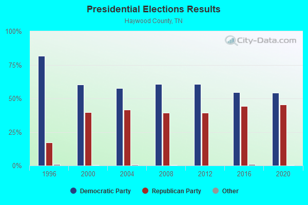
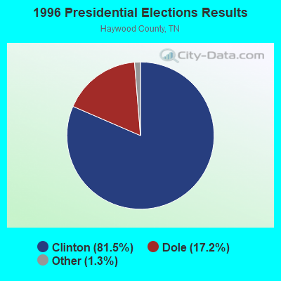
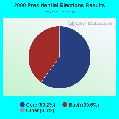
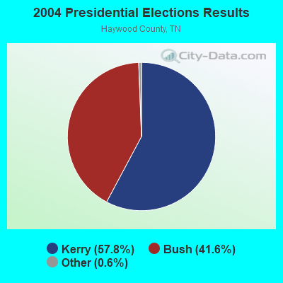

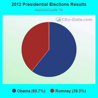
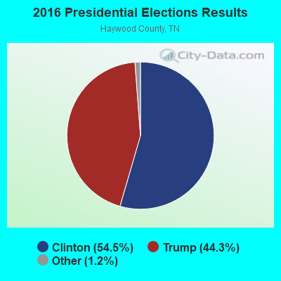
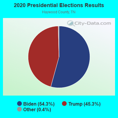
Graphs represent county-level data. Detailed 2008 Election Results
Religion statistics for Woodland, TN (based on Haywood County data)
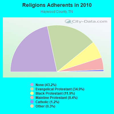
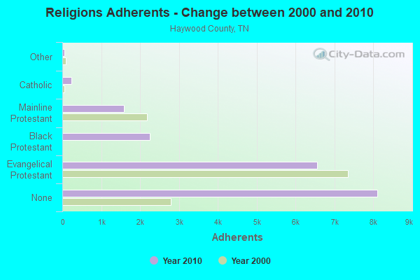
| Religion | Adherents | Congregations |
|---|---|---|
| Evangelical Protestant | 6,552 | 25 |
| Black Protestant | 2,245 | 15 |
| Mainline Protestant | 1,583 | 15 |
| Catholic | 232 | 1 |
| Other | 62 | 2 |
| None | 8,113 | - |
Food Environment Statistics:
| This county: | 1.57 / 10,000 pop. |
| State: | 1.99 / 10,000 pop. |
| Haywood County: | 0.52 / 10,000 pop. |
| Tennessee: | 0.65 / 10,000 pop. |
| Haywood County: | 6.27 / 10,000 pop. |
| Tennessee: | 5.16 / 10,000 pop. |
| Haywood County: | 4.18 / 10,000 pop. |
| State: | 6.56 / 10,000 pop. |
| Here: | 12.7% |
| Tennessee: | 11.4% |
| Haywood County: | 35.4% |
| Tennessee: | 30.2% |
| Haywood County: | 13.3% |
| State: | 13.5% |
Strongest AM radio stations in Woodland:
- WCRV (640 AM; 50 kW; COLLIERVILLE, TN; Owner: BOTT BROADCASTING COMPANY/TENNESSEE)
- WGSF (1030 AM; 50 kW; MEMPHIS, TN; Owner: FLINN BROADCASTING CORPORATION)
- WMQM (1600 AM; 50 kW; LAKELAND, TN; Owner: WMQM, INC.)
- WDIA (1070 AM; 50 kW; MEMPHIS, TN; Owner: CLEAR CHANNEL BROADCASTING LICENSES, INC.)
- WTJS (1390 AM; 5 kW; JACKSON, TN; Owner: CAPSTAR TX LIMITED PARTNERSHIP)
- WDXI (1310 AM; 5 kW; JACKSON, TN; Owner: LIBERTY RADIO II, INC.)
- WJCE (680 AM; 10 kW; MEMPHIS, TN; Owner: ENTERCOM MEMPHIS LICENSE, LLC)
- WCPC (940 AM; 50 kW; HOUSTON, MS; Owner: WCPC BROADCASTING CO., INC.)
- WSM (650 AM; 50 kW; NASHVILLE, TN; Owner: GAYLORD ENTERTAINMENT COMPANY)
- KWAM (990 AM; 10 kW; MEMPHIS, TN; Owner: CONCORD MEDIA GROUP, INC.)
- WPLX (1170 AM; 10 kW; GERMANTOWN, TN; Owner: EDUCATIONAL MEDIA FOUNDATION)
- WNWS (1520 AM; daytime; 0 kW; BROWNSVILLE, TN; Owner: THE WIRELESS GROUP INC.)
- WHBQ (560 AM; 5 kW; MEMPHIS, TN; Owner: FLINN BROADCASTING CORPORATION)
Strongest FM radio stations in Woodland:
- WTBG (95.3 FM; BROWNSVILLE, TN; Owner: THE WIRELESS GROUP, INC.)
- WWGM (93.1 FM; ALAMO, TN; Owner: GRACE BROADCASTING SERVICES, INC.)
- WTNV (104.1 FM; JACKSON, TN; Owner: CAPSTAR TX LIMITED PARTNERSHIP)
- WKNP (90.1 FM; JACKSON, TN; Owner: MID-SOUTH PUBLIC COMMUNICTNS FOUNDTN)
- WMXX-FM (103.1 FM; JACKSON, TN; Owner: GERALD W. HUNT)
- WYNU (92.3 FM; MILAN, TN; Owner: CAPSTAR TX LIMITED PARTNERSHIP)
- WWYN (106.9 FM; MCKENZIE, TN; Owner: RAINBOW MEDIA, INC.)
- WSRR-FM (98.1 FM; MILLINGTON, TN; Owner: KOOL BROADCASTING, INC.)
- WEGR (102.7 FM; MEMPHIS, TN; Owner: CLEAR CHANNEL BROADCASTING LICENSES, INC.)
- WNWS-FM (101.5 FM; JACKSON, TN; Owner: RADIOCORP OF JACKSON, INC.)
- WIGH (88.7 FM; LEXINGTON, TN; Owner: AMERICAN FAMILY ASSOCIATION)
- WAPO (90.5 FM; MOUNT VERNON, IL; Owner: AMERICAN FAMILY ASSOCIATION)
- WAUV (89.7 FM; RIPLEY, TN; Owner: AMERICAN FAMILY ASSOCIATION)
- WOJG (94.7 FM; BOLIVAR, TN; Owner: JOHNNY W. SHAW & OPAL J. SHAW)
- WZDQ (102.3 FM; HUMBOLDT, TN; Owner: THOMAS RADIO, LLC)
- WHHM-FM (107.7 FM; HENDERSON, TN; Owner: THOMAS RADIO, LLC)
- WFKX (95.7 FM; HENDERSON, TN; Owner: THOMAS RADIO, LLC)
TV broadcast stations around Woodland:
- WJKT (Channel 16; JACKSON, TN; Owner: CLEAR CHANNEL BROADCASTING LICENSES, INC.)
- WBBJ-TV (Channel 7; JACKSON, TN; Owner: TENNESSEE BROADCASTING PARTNERS)
- W25BY (Channel 25; JACKSON, TN; Owner: MS COMMUNICATIONS, LLC)
- W38BY (Channel 38; JACKSON, TN; Owner: MS COMMUNICATIONS, LLC)
- W54BU (Channel 54; JACKSON, TN; Owner: MS COMMUNICATIONS, LLC)
- W22BR (Channel 22; JACKSON, TN; Owner: MS COMMUNICATIONS, LLC)
- W52CZ (Channel 52; JACKSON, TN; Owner: MS COMMUNICATIONS, LLC)
- W64BZ (Channel 64; JACKSON, TN; Owner: MS COMMUNICATIONS, LLC)
- W35AH (Channel 35; JACKSON, TN; Owner: TRINITY BROADCASTING NETWORK)
- WJTE-LP (Channel 19; JACKSON, TN; Owner: TIGER EYE BROADCASTING CORPORATION)
- W26CJ (Channel 26; JACKSON, TN; Owner: MS COMMUNICATIONS, LLC)
- WMC-TV (Channel 5; MEMPHIS, TN; Owner: RAYCOM AMERICA, INC.)
- WLMT (Channel 30; MEMPHIS, TN; Owner: CLEAR CHANNEL BROADCASTING LICENSES, INC.)
- WPTY-TV (Channel 24; MEMPHIS, TN; Owner: CLEAR CHANNEL BROADCASTING LICENSES, INC.)
- WPXX-TV (Channel 50; MEMPHIS, TN; Owner: FLINN BROADCASTING CORPORATION)
- W46CG (Channel 46; JACKSON, TN; Owner: MS COMMUNICATIONS, LLC)

- 36.8%Electricity
- 35.7%Bottled, tank, or LP gas
- 18.7%Utility gas
- 3.7%Wood
- 2.8%Fuel oil, kerosene, etc.
- 2.3%Other fuel

- 52.6%Bottled, tank, or LP gas
- 40.2%Electricity
- 7.2%Wood
Woodland compared to Tennessee state average:
- Median house value below state average.
- Unemployed percentage below state average.
- Black race population percentage above state average.
- Hispanic race population percentage significantly below state average.
- Foreign-born population percentage significantly below state average.
- Renting percentage significantly below state average.
- Length of stay since moving in significantly above state average.
- Number of rooms per house significantly below state average.
- House age significantly below state average.
- Institutionalized population percentage significantly above state average.
- Number of college students below state average.
- Percentage of population with a bachelor's degree or higher significantly below state average.