Western, New York
Submit your own pictures of this town and show them to the world
- OSM Map
- Google Map
- MSN Map
Population change since 2000: -3.8%
 |
| Males: 999 | |
| Females: 952 |
| Median resident age: | 43.9 years |
| New York median age: | 40.7 years |
Zip codes: 13303.
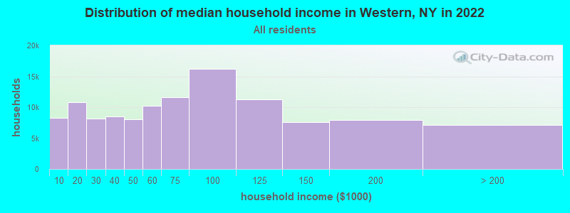
| Western: | $75,829 |
| NY: | $79,557 |
Estimated per capita income in 2022: $38,590 (it was $20,217 in 2000)
Western town income, earnings, and wages data
Estimated median house or condo value in 2022: $177,763 (it was $77,500 in 2000)
| Western: | $177,763 |
| NY: | $400,400 |
Mean prices in 2022: all housing units: $197,131; detached houses: $205,775; townhouses or other attached units: $204,104; in 2-unit structures: $275,728; in 3-to-4-unit structures: $126,003; in 5-or-more-unit structures: $544,387; mobile homes: $61,833
Detailed information about poverty and poor residents in Western, NY
Compare current foreclosures near Western, NY:
| Photo | Address | Area | Beds / Baths | Price | Details |
|---|---|---|---|---|---|

|
#1
Riverview Pkwy N
Rome, NY 13440
|
1,008 sq. feet
|
1 baths 2 beds |
$114,900
|
show details |

|
#2
Old State Route 12
Remsen, NY 13438
|
1,288 sq. feet
|
2 baths 3 beds |
$83,250
|
show details |

|
#3
Willow Dr
Utica, NY 13502
|
1,665 sq. feet
|
2 baths 3 beds |
show details | |

|
#4
Healy Ave
Rome, NY 13440
|
1,566 sq. feet
|
1 baths 3 beds |
show details | |

|
#5
Marnie St
Utica, NY 13502
|
1,485 sq. feet
|
1 baths 3 beds |
show details | |

|
#6
Marnie St
Utica, NY 13502
|
1,485 sq. feet
|
1 baths 3 beds |
show details | |

|
#7
Floyd Ave
Rome, NY 13440
|
2,040 sq. feet
|
2 baths 5 beds |
show details | |

|
#8
Glendale Pl
Whitesboro, NY 13492
|
1,369 sq. feet
|
1 baths 2 beds |
show details | |

|
#9
Mayberry Rd
Rome, NY 13440
|
1,237 sq. feet
|
1 baths 2 beds |
show details | |

|
#10
Mcconnellsville Rd
Blossvale, NY 13308
|
1,007 sq. feet
|
1 baths 3 beds |
show details |
| Photo | Address | Area | Beds / Baths | Price | Details |
|---|---|---|---|---|---|

|
#11
Floyd Ave
Rome, NY 13440
|
1,637 sq. feet
|
1 baths 3 beds |
show details | |

|
#12
Pine Grove Ln
Marcy, NY 13403
|
2,257 sq. feet
|
3 baths 4 beds |
show details | |

|
#13
W Thomas St
Rome, NY 13440
|
1,673 sq. feet
|
2 baths 3 beds |
show details | |

|
#14
W Embargo St
Rome, NY 13440
|
850 sq. feet
|
1 baths 3 beds |
show details | |

|
#15
E Schuyler St
Boonville, NY 13309
|
1,678 sq. feet
|
1 baths 2 beds |
show details | |

|
#16
Brainard St
Whitesboro, NY 13492
|
1,425 sq. feet
|
1 baths 2 beds |
show details | |

|
#17
Mathews Ave
Utica, NY 13502
|
891 sq. feet
|
1 baths 3 beds |
show details | |

|
#18
1st St
Whitesboro, NY 13492
|
1,267 sq. feet
|
1 baths 2 beds |
show details | |

|
#19
New Floyd Rd
Rome, NY 13440
|
1,848 sq. feet
|
2 baths 3 beds |
show details | |

|
#20
River Rd
Marcy, NY 13403
|
1,807 sq. feet
|
1 baths 2 beds |
show details |
| Photo | Address | Area | Beds / Baths | Price | Details |
|---|---|---|---|---|---|

|
#21
Rome Taberg Rd
Rome, NY 13440
|
1,188 sq. feet
|
1 baths 2 beds |
show details | |

|
#22
Pinecrest Rd
Whitesboro, NY 13492
|
1,085 sq. feet
|
1 baths 3 beds |
show details | |

|
#23
Stanwix Ave
Rome, NY 13440
|
927 sq. feet
|
1 baths 1 beds |
show details | |

|
#24
Main St
Boonville, NY 13309
|
2,152 sq. feet
|
2 baths 5 beds |
show details | |

|
#25
1/2 Boon Street
Barneveld, NY 13304
|
- sq. feet
|
1 baths 3 beds |
show details | |

|
#26
Passer Rd
Blossvale, NY 13308
|
1,170 sq. feet
|
2 baths 3 beds |
show details | |

|
#27
Walker Rd
Utica, NY 13502
|
961 sq. feet
|
1 baths 3 beds |
show details | |

|
#28
Coleman Mills Rd
Rome, NY 13440
|
1,269 sq. feet
|
1 baths 3 beds |
show details | |

|
#29
Aitken Ave
Whitesboro, NY 13492
|
1,860 sq. feet
|
2 baths 4 beds |
show details | |

|
#30
Husted Dr
Oriskany, NY 13424
|
1,660 sq. feet
|
2 baths 3 beds |
show details |
| Photo | Address | Area | Beds / Baths | Price | Details |
|---|---|---|---|---|---|

|
#31
Maynard Ave
Utica, NY 13502
|
1,742 sq. feet
|
1 baths 3 beds |
show details | |

|
#32
2nd St
Yorkville, NY 13495
|
- sq. feet
|
1 baths 3 beds |
show details | |

|
#33
Passer Rd
Blossvale, NY 13308
|
1,219 sq. feet
|
1 baths 3 beds |
show details | |

|
#34
Cavanaugh Rd # Ws
Marcy, NY 13403
|
1,565 sq. feet
|
1 baths 3 beds |
show details | |

|
#35
Tabor Pl
Utica, NY 13502
|
1,548 sq. feet
|
1 baths 3 beds |
show details | |

|
#36
Locust Dr
Utica, NY 13502
|
1,296 sq. feet
|
1 baths 3 beds |
show details | |

|
#37
Eastwood Dr
Verona, NY 13478
|
1,044 sq. feet
|
1 baths 3 beds |
show details | |

|
#38
Trenton Rd
Barneveld, NY 13304
|
1,320 sq. feet
|
1 baths 3 beds |
show details | |

|
#39
Carey St
Rome, NY 13440
|
1,964 sq. feet
|
2 baths 4 beds |
show details | |

|
#40
Sinclair Ave
Utica, NY 13502
|
1,728 sq. feet
|
1 baths 4 beds |
show details |
| Photo | Address | Area | Beds / Baths | Price | Details |
|---|---|---|---|---|---|

|
#41
Park Dr
Rome, NY 13440
|
780 sq. feet
|
1 baths 2 beds |
show details | |

|
#42
Wilson Rd E
Taberg, NY 13471
|
- sq. feet
|
2 baths 3 beds |
show details | |

|
#43
W Bloomfield St
Rome, NY 13440
|
1,242 sq. feet
|
1 baths 3 beds |
show details | |

|
#44
Russell Ave
Yorkville, NY 13495
|
1,110 sq. feet
|
1 baths 3 beds |
show details | |

|
#45
Flint Town Rd
Boonville, NY 13309
|
870 sq. feet
|
1 baths 4 beds |
show details | |

|
#46
Northwood Dr
Rome, NY 13440
|
1,680 sq. feet
|
2 baths 3 beds |
show details | |

|
#47
Turin Rd
Rome, NY 13440
|
1,510 sq. feet
|
2 baths 5 beds |
show details | |

|
#48
Kimball Rd
Blossvale, NY 13308
|
1,854 sq. feet
|
3 baths 3 beds |
show details | |

|
#49
Spring Rd
Verona, NY 13478
|
1,040 sq. feet
|
2 baths 3 beds |
show details | |

|
Check over 1 million property listings on Foreclosure.com!
|
browse all offers | |||

- 1,88596.6%White alone
- 331.7%Hispanic
- 130.7%Asian alone
- 120.6%Black alone
- 70.4%Two or more races
- 10.05%Other race alone

Races in Western detailed stats: ancestries, foreign born residents, place of birth
 Recent articles from our blog. Our writers, many of them Ph.D. graduates or candidates, create easy-to-read articles on a wide variety of topics.
Ancestries: German (24.1%), Irish (17.0%), English (15.5%), Italian (11.3%), Polish (10.7%), Welsh (6.9%).
Current Local Time: EST time zone
Land area: 51.4 square miles.
Population density: 38 people per square mile (very low).
60 residents are foreign born (1.9% Asia, 0.6% North America, 0.4% Europe).
| This town: | 3.0% |
| New York: | 20.4% |
| Western town: | 2.1% ($1,665) |
| New York: | 1.9% ($2,847) |
Nearest city with pop. 50,000+: Utica, NY  (17.8 miles , pop. 60,651).
Nearest city with pop. 200,000+: Rochester, NY (112.3 miles , pop. 219,773).
Nearest city with pop. 1,000,000+: Bronx, NY (188.4 miles , pop. 1,332,650).
Nearest cities:
), ), ), ), ), )Latitude: 43.33 N, Longitude: 75.39 W
Area code commonly used in this area: 315
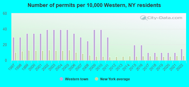
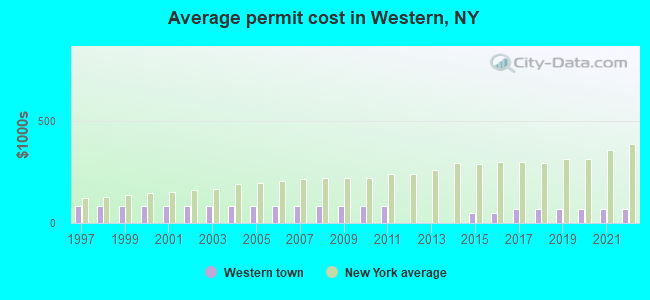
Single-family new house construction building permits:
- 2022: 3 buildings, average cost: $69,000
- 2021: 2 buildings, average cost: $69,000
- 2020: 2 buildings, average cost: $69,000
- 2019: 2 buildings, average cost: $69,000
- 2018: 2 buildings, average cost: $69,000
- 2017: 2 buildings, average cost: $69,000
- 2016: 4 buildings, average cost: $50,000
- 2015: 4 buildings, average cost: $50,000
- 2011: 6 buildings, average cost: $85,000
- 2010: 8 buildings, average cost: $85,000
- 2009: 8 buildings, average cost: $85,000
- 2008: 5 buildings, average cost: $85,000
- 2007: 6 buildings, average cost: $85,000
- 2006: 7 buildings, average cost: $85,000
- 2005: 8 buildings, average cost: $85,000
- 2004: 8 buildings, average cost: $85,000
- 2003: 8 buildings, average cost: $85,000
- 2002: 8 buildings, average cost: $85,000
- 2001: 7 buildings, average cost: $85,000
- 2000: 7 buildings, average cost: $85,000
- 1999: 7 buildings, average cost: $85,000
- 1998: 6 buildings, average cost: $85,000
- 1997: 6 buildings, average cost: $85,000
| Here: | 4.2% |
| New York: | 4.4% |
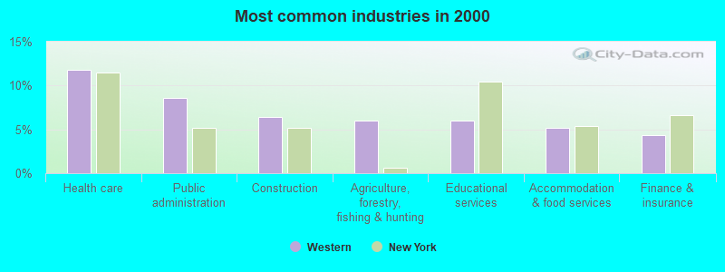
- Health care (11.8%)
- Public administration (8.6%)
- Construction (6.5%)
- Agriculture, forestry, fishing & hunting (6.0%)
- Educational services (6.0%)
- Accommodation & food services (5.1%)
- Finance & insurance (4.3%)
- Construction (11.7%)
- Public administration (9.9%)
- Agriculture, forestry, fishing & hunting (9.1%)
- Health care (4.8%)
- Accommodation & food services (4.7%)
- Metal & metal products (4.5%)
- Professional, scientific, technical services (3.4%)
- Health care (20.3%)
- Educational services (10.9%)
- Finance & insurance (7.3%)
- Public administration (7.1%)
- Accommodation & food services (5.7%)
- Social assistance (5.5%)
- Arts, entertainment, recreation (4.8%)
- Other sales and related occupations, including supervisors (4.6%)
- Other management occupations, except farmers and farm managers (4.1%)
- Other office and administrative support workers, including supervisors (3.4%)
- Law enforcement workers, including supervisors (3.1%)
- Farmers and farm managers (3.0%)
- Agricultural workers, including supervisors (2.9%)
- Engineers (2.8%)
- Other management occupations, except farmers and farm managers (5.2%)
- Engineers (5.0%)
- Driver/sales workers and truck drivers (5.0%)
- Vehicle and mobile equipment mechanics, installers, and repairers (4.8%)
- Agricultural workers, including supervisors (4.8%)
- Law enforcement workers, including supervisors (4.8%)
- Other sales and related occupations, including supervisors (4.7%)
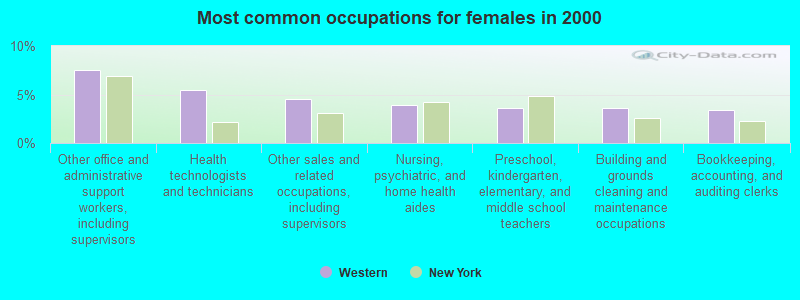
- Other office and administrative support workers, including supervisors (7.5%)
- Health technologists and technicians (5.5%)
- Other sales and related occupations, including supervisors (4.6%)
- Nursing, psychiatric, and home health aides (3.9%)
- Preschool, kindergarten, elementary, and middle school teachers (3.6%)
- Building and grounds cleaning and maintenance occupations (3.6%)
- Bookkeeping, accounting, and auditing clerks (3.4%)
Average climate in Western, New York
Based on data reported by over 4,000 weather stations


(lower is better)
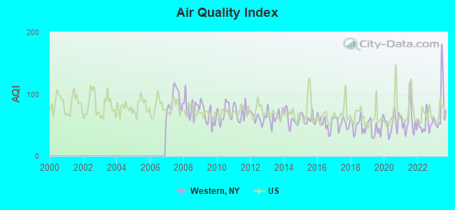
Air Quality Index (AQI) level in 2023 was 77.3. This is about average.
| City: | 77.3 |
| U.S.: | 72.6 |
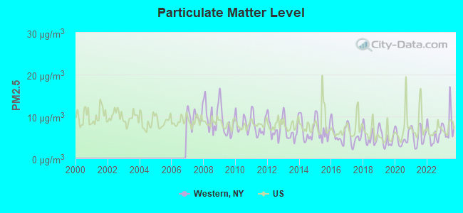
Particulate Matter (PM2.5) [µg/m3] level in 2023 was 7.86. This is about average. Closest monitor was 17.9 miles away from the city center.
| City: | 7.86 |
| U.S.: | 8.11 |
Tornado activity:
Western-area historical tornado activity is below New York state average. It is 78% smaller than the overall U.S. average.
On 5/2/1983, a category F3 (max. wind speeds 158-206 mph) tornado 10.7 miles away from the Western town center caused between $5,000,000 and $50,000,000 in damages.
On 7/23/1990, a category F2 (max. wind speeds 113-157 mph) tornado 8.1 miles away from the town center caused between $5000 and $50,000 in damages.
Earthquake activity:
Western-area historical earthquake activity is significantly above New York state average. It is 68% smaller than the overall U.S. average.On 10/7/1983 at 10:18:46, a magnitude 5.3 (5.1 MB, 5.3 LG, 5.1 ML, Class: Moderate, Intensity: VI - VII) earthquake occurred 68.1 miles away from Western center
On 4/20/2002 at 10:50:47, a magnitude 5.3 (5.3 ML, Depth: 3.0 mi) earthquake occurred 117.7 miles away from Western center
On 4/20/2002 at 10:50:47, a magnitude 5.2 (5.2 MB, 4.2 MS, 5.2 MW, 5.0 MW) earthquake occurred 115.8 miles away from Western center
On 6/17/1991 at 08:53:16, a magnitude 4.1 (4.0 MB, 4.0 LG, Depth: 3.1 mi, Class: Light, Intensity: IV - V) earthquake occurred 60.2 miles away from Western center
On 9/25/1998 at 19:52:52, a magnitude 5.2 (4.8 MB, 4.3 MS, 5.2 LG, 4.5 MW, Depth: 3.1 mi) earthquake occurred 285.3 miles away from the city center
On 1/19/1982 at 00:14:42, a magnitude 4.7 (4.5 MB, 4.7 MD, 4.5 LG) earthquake occurred 190.9 miles away from Western center
Magnitude types: regional Lg-wave magnitude (LG), body-wave magnitude (MB), duration magnitude (MD), local magnitude (ML), surface-wave magnitude (MS), moment magnitude (MW)
Natural disasters:
The number of natural disasters in Oneida County (23) is greater than the US average (15).Major Disasters (Presidential) Declared: 12
Emergencies Declared: 9
Causes of natural disasters: Storms: 9, Floods: 7, Tropical Storms: 3, Hurricanes: 2, Snows: 2, Snowstorms: 2, Winds: 2, Blizzard: 1, Ice Storm: 1, Power Outage: 1, Tornado: 1, Winter Storm: 1, Other: 2 (Note: some incidents may be assigned to more than one category).
Hospitals and medical centers near Western:
- CENTRAL NEW YORK DDSO (Hospital, about 7 miles away; ROME, NY)
- BETHANY GARDENS SKILLED LIVING CENTER (Nursing Home, about 7 miles away; ROME, NY)
- ROME MEMORIAL HOSPITAL, INC Acute Care Hospitals (about 8 miles away; ROME, NY)
- BETSY ROSS REHABILITATION CTR (Nursing Home, about 8 miles away; ROME, NY)
- COLONIAL PARK REHABILITATION AND NURSING CENTER (Nursing Home, about 8 miles away; ROME, NY)
- ROME CENTER FOR REHABILITATION AND HEALTH CARE (Nursing Home, about 8 miles away; ROME, NY)
- UCPA OF THE UTICA AREA (Hospital, about 8 miles away; ROME, NY)
Amtrak stations near Western:
- 10 miles: ROME (6599 MARTIN ST.) . Services: enclosed waiting area, public restrooms, public payphones, full-service food facilities, free short-term parking, free long-term parking, call for car rental service, call for taxi service, public transit connection.
- 18 miles: UTICA (321 MAIN ST.) . Services: ticket office, partially wheelchair accessible, enclosed waiting area, public restrooms, public payphones, snack bar, free short-term parking, call for car rental service, taxi stand, intercity bus service, public transit connection.
Colleges/universities with over 2000 students nearest to Western:
- Utica College (about 18 miles; Utica, NY; Full-time enrollment: 2,952)
- Mohawk Valley Community College (about 20 miles; Utica, NY; FT enrollment: 5,693)
- Herkimer County Community College (about 29 miles; Herkimer, NY; FT enrollment: 2,774)
- Morrisville State College (about 32 miles; Morrisville, NY; FT enrollment: 2,823)
- Colgate University (about 36 miles; Hamilton, NY; FT enrollment: 3,094)
- Le Moyne College (about 41 miles; Syracuse, NY; FT enrollment: 3,041)
- Syracuse University (about 43 miles; Syracuse, NY; FT enrollment: 20,717)
Points of interest:
Notable location: Western Town Library (A). Display/hide its location on the map
Churches in Western include: North Western United Methodist Church (A), Westernville United Methodist Church (B). Display/hide their locations on the map
Cemeteries: Rogers Cemetery (1), Frenchville Cemetery (2), Welsh Cemetery (3), Stone Cemetery (4), Delta Cemetery (5), Nisbet Cemetery (6), Carmichael Hill Cemetery (7). Display/hide their locations on the map
Reservoir: Delta Reservoir (A). Display/hide its location on the map
Streams, rivers, and creeks: Gulf Creek (A), Gifford Creek (B), Bunt Brook (C), Flint Brook (D), Lansing Kill (E), Dunn Brook (F), Blue Brook (G), Spinks Brook (H), Deans Gulf (I). Display/hide their locations on the map
| This town: | 2.5 people |
| New York: | 2.6 people |
| This town: | 69.5% |
| Whole state: | 63.5% |
| This town: | 8.8% |
| Whole state: | 6.8% |
Likely homosexual households (counted as self-reported same-sex unmarried-partner households)
- Lesbian couples: 0.1% of all households
- Gay men: 0.6% of all households
| This town: | 8.0% |
| Whole state: | 14.6% |
| This town: | 3.3% |
| Whole state: | 7.4% |
For population 15 years and over in Western:
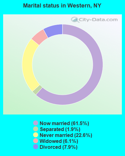
- Never married: 22.6%
- Now married: 61.5%
- Separated: 1.9%
- Widowed: 6.1%
- Divorced: 7.9%
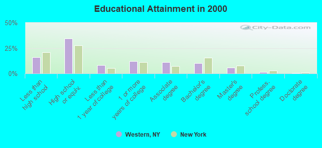
For population 25 years and over in Western:
- High school or higher: 83.8%
- Bachelor's degree or higher: 17.8%
- Graduate or professional degree: 7.8%
- Unemployed: 4.9%
- Mean travel time to work (commute): 26.3 minutes
| Here: | 10.9 |
| New York average: | 14.2 |
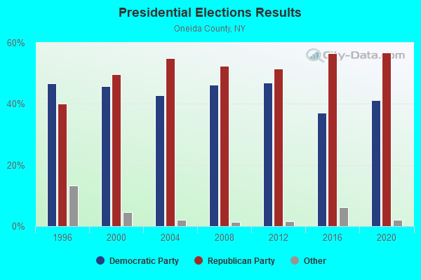
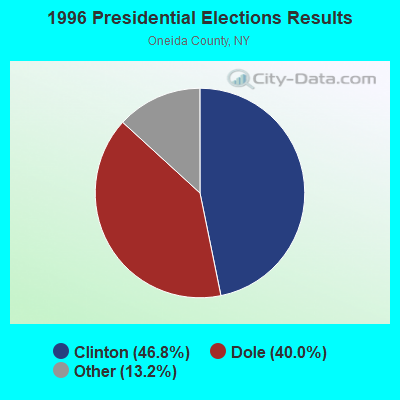
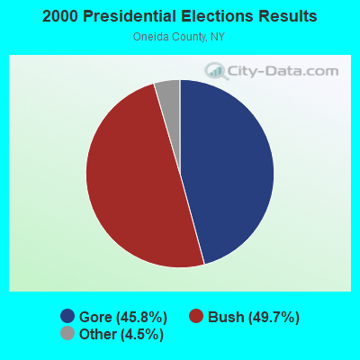
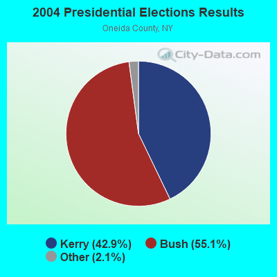
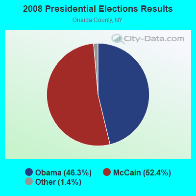
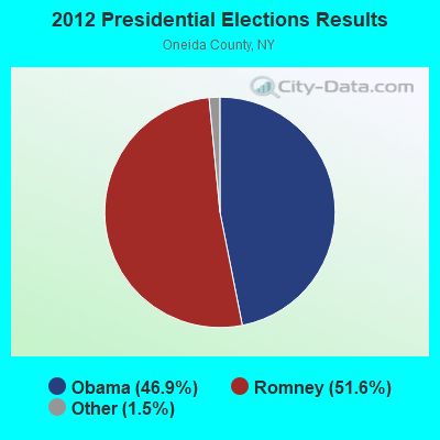
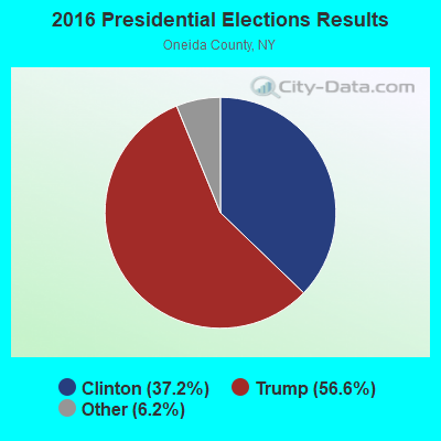
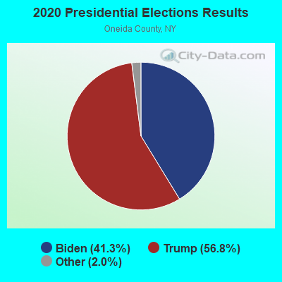
Graphs represent county-level data. Detailed 2008 Election Results
Religion statistics for Western, NY (based on Oneida County data)
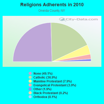
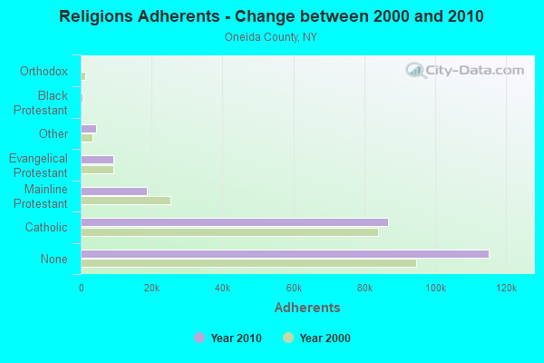
| Religion | Adherents | Congregations |
|---|---|---|
| Catholic | 86,750 | 51 |
| Mainline Protestant | 18,610 | 95 |
| Evangelical Protestant | 9,119 | 75 |
| Other | 4,416 | 16 |
| Black Protestant | 504 | 4 |
| Orthodox | 270 | 3 |
| None | 115,209 | - |
Food Environment Statistics:
| Here: | 2.12 / 10,000 pop. |
| State: | 4.13 / 10,000 pop. |
| Oneida County: | 0.13 / 10,000 pop. |
| New York: | 0.06 / 10,000 pop. |
| Oneida County: | 0.47 / 10,000 pop. |
| New York: | 0.92 / 10,000 pop. |
| Oneida County: | 3.24 / 10,000 pop. |
| New York: | 1.68 / 10,000 pop. |
| Here: | 8.85 / 10,000 pop. |
| New York: | 8.82 / 10,000 pop. |
| Oneida County: | 8.8% |
| New York: | 8.2% |
| This county: | 24.4% |
| State: | 23.8% |
| Oneida County: | 15.0% |
| New York: | 15.6% |
Strongest AM radio stations in Western:
- WRUN (1150 AM; 5 kW; UTICA, NY)
- WADR (1480 AM; 5 kW; REMSEN, NY; Owner: CLEAR CHANNEL BROADCASTING LICENSES, INC.)
- WIBX (950 AM; 5 kW; UTICA, NY; Owner: REGENT LICENSEE OF UTICA/ROME, INC.)
- WTLB (1310 AM; 5 kW; UTICA, NY; Owner: GALAXY COMMUNICATIONS, L.P.)
- WGY (810 AM; 50 kW; SCHENECTADY, NY; Owner: CLEAR CHANNEL BROADCASTING LICENSES, INC.)
- WBRV (900 AM; 1 kW; BOONVILLE, NY)
- WPTR (1540 AM; 50 kW; ALBANY, NY; Owner: KIMTRON, INC.)
- WRNY (1350 AM; 0 kW; ROME, NY; Owner: CLEAR CHANNEL BROADCASTING LICENSES, INC.)
- WHEN (620 AM; 5 kW; SYRACUSE, NY; Owner: CLEAR CHANNEL BROADCASTING LICENSES, INC.)
- WSYR (570 AM; 5 kW; SYRACUSE, NY; Owner: CLEAR CHANNEL BROADCASTING LICENSES, INC.)
- WNNZ (640 AM; 50 kW; WESTFIELD, MA; Owner: CLEAR CHANNEL BROADCASTING LICENSES, INC.)
- WHAM (1180 AM; 50 kW; ROCHESTER, NY; Owner: CITICASTERS LICENSES, L.P.)
- WNSS (1260 AM; 5 kW; SYRACUSE, NY; Owner: CITADEL BROADCASTING COMPANY)
Strongest FM radio stations in Western:
- WUCL (93.5 FM; REMSEN, NY; Owner: CLEAR CHANNEL BROADCASTING LICENSES, INC.)
- WODZ-FM (96.1 FM; ROME, NY; Owner: REGENT LICENSEE OF UTICA/ROME, INC.)
- WBRV-FM (101.3 FM; BOONVILLE, NY; Owner: THE FLACK BROADCASTING GROUP L.L.C.)
- WOUR (96.9 FM; UTICA, NY; Owner: CLEAR CHANNEL BROADCASTING LICENSES, INC.)
- WUNY (89.5 FM; UTICA, NY; Owner: PUBLIC BC COUNCIL OF CENTRAL NY, INC)
- WLZW (98.7 FM; UTICA, NY; Owner: REGENT LICENSEE OF UTICA/ROME, INC.)
- WKVU (100.7 FM; UTICA, NY; Owner: EDUCATIONAL MEDIA FOUNDATION)
- WKLL (94.9 FM; FRANKFORT, NY; Owner: GALAXY COMMUNICATIONS, L.P.)
- WSKS (97.9 FM; WHITESBORO, NY; Owner: CLEAR CHANNEL BROADCASTING LICENSES, INC.)
- WRBY (102.5 FM; ROME, NY; Owner: CLEAR CHANNEL BROADCASTING LICENSES, INC.)
- WRCK (107.3 FM; UTICA, NY; Owner: GALAXY COMMUNICATIONS, L.P.)
- WBGK (99.7 FM; NEWPORT VILLAGE, NY; Owner: ROSER COMMUNICATIONS NETWORK, INC.)
- WMCR-FM (106.3 FM; ONEIDA, NY; Owner: WARREN BROADCASTING CO. INC.)
- WFRG-FM (104.3 FM; UTICA, NY; Owner: REGENT LICENSEE OF UTICA/ROME, INC.)
- WBDI (106.7 FM; COPENHAGEN, NY; Owner: FORCE COMMUNICATIONS, INC)
- WJNY (90.9 FM; WATERTOWN, NY; Owner: PUBLIC B/CNG COUNCIL CENTRAL NY, INC)
- WBGJ (100.3 FM; SYLVAN BEACH, NY; Owner: WOLF RADIO, INC.)
- WWDG (105.1 FM; DERUYTER, NY; Owner: CLEAR CHANNEL BROADCASTING LICENSES, INC.)
- WLLG (99.3 FM; LOWVILLE, NY; Owner: THE FLACK BROADCASTING GROUP L.L.C.)
TV broadcast stations around Western:
- WFXV (Channel 33; UTICA, NY; Owner: QUORUM OF UTICA LICENSE, LLC)
- WKTV (Channel 2; UTICA, NY; Owner: SMITH TELEVISION OF NEW YORK LICENSE HOLDINGS, INC.)
- W12BZ (Channel 12; ROME, NY; Owner: KEVIN O'KANE)
- WSPX-TV (Channel 56; SYRACUSE, NY; Owner: PAXSON SYRACUSE LICENSE, INC.)
- WUTR (Channel 20; UTICA, NY; Owner: CENTRAL NY NEWS, INC.)
- WPNY-LP (Channel 11; UTICA, ETC., NY; Owner: QUORUM OF UTICA LICENSE, LLC)
- W59AU (Channel 59; UTICA, NY; Owner: PUBLIC B/CING.COUNCIL,CENTRAL N. Y.)
- WIXT-TV (Channel 9; SYRACUSE, NY; Owner: CENTRAL NY NEWS, INC.)
- WCNY-TV (Channel 24; SYRACUSE, NY; Owner: PUBLIC BROADCASTING COUNCIL OF CENTRAL NEW YORK)
- WNYS-TV (Channel 43; SYRACUSE, NY; Owner: RKM MEDIA, INC.)
- W53AM (Channel 53; UTICA, NY; Owner: QUORUM OF UTICA LICENSE, LLC)
- WWTI (Channel 50; WATERTOWN, NY; Owner: CENTRAL NY NEWS, INC.)
- WPBS-TV (Channel 16; WATERTOWN, NY; Owner: ST. LAWRENCE VALLEY EDUCATIONAL TV COUNCIL, INC)
- W51CV (Channel 51; UTICA, NY; Owner: TRINITY BROADCASTING NETWORK)
- National Bridge Inventory (NBI) Statistics
- 16Number of bridges
- 112ft / 34.3mTotal length
- $14,534,000Total costs
- 7,761Total average daily traffic
- 424Total average daily truck traffic
- 8,753Total future (year 2036) average daily traffic
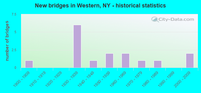
- New bridges - historical statistics
- 11900-1909
- 61930-1939
- 11940-1949
- 21950-1959
- 21960-1969
- 11970-1979
- 11980-1989
- 22000-2009
FCC Registered Antenna Towers:
7- Joseph F Rositano, 9913 Wilson Road (Lat: 43.340278 Lon: -75.420278), Type: 51.8, Overall height: 45.7 m, Registrant: Jpj Electronic Communications, Jpjeci@dreamscape.Com, , Yorkv-ille, Phone: (315) 733-8495
- Joseph F Rositano, 9913 Wilson Road (Lat: 43.340278 Lon: -75.420278), Type: 51.8, Overall height: 45.7 m, Registrant: Jpj Electronic Communications, Jpjeci@dreamscape.Com, , Yorkv-ille, Phone: (315) 733-8495
- JOSEPH F ROSITANO, 9913 Wilson Road (Lat: 43.340278 Lon: -75.420556), Type: 17.0, Structure height: 36065 m, Overall height: 12 m, Registrant: Adaptable Commercial Properties, Inc, Joe@jpje.Com, , Yorkv-ille, Phone: (315) 796-1521
- JOSEPH F ROSITANO, 9913 Wilson Road (Lat: 43.340278 Lon: -75.420278), Type: 51.8, Structure height: 36065 m, Overall height: 45.7 m, Licensee ID: C, Registrant: Adaptable Commercial Properties, Inc, Joe@jpje.Com, , Yorkv-ille, Phone: (315) 796-1521
- Greg Thompson, 9913 Wilson Road (Lat: 43.340278 Lon: -75.420278), Type: 51.8, Structure height: 36065 m, Overall height: 45.7 m, Licensee ID: L, Registrant: K2 Towers Iii, LLC, Rlepene@k2towers.Com, , Chagr-in Falls, Phone: (440) 528-0333
- Greg Thompson, 9913 Wilson Road (Lat: 43.340278 Lon: -75.420556), Type: 17.0, Structure height: 36065 m, Overall height: 12 m, Registrant: K2 Towers Iii, LLC, Gthompson@k2towers.Com, , Chagr-in Falls, Phone: (440) 263-8999
- 9913 Wilson Road (Lat: 43.340278 Lon: -75.420556), Type: 17.0, Overall height: 12 m, Registrant: Jpj Electronic Communications Inc., Yorkv-ille, Phone: (315) 733-8495
FCC Registered Paging Towers:
1- 9913 Wilson Road (Lat: 43.340333 Lon: -75.420444), Structure height: 45.7 m, Overall height: 51.8 m, Call Sign: KEA253,
Assigned Frequencies: 152.030 MHz, Grant Date: 05/24/1999, Expiration Date: 04/01/2009, Cancellation Date: 08/25/2006, Registrant: Shulman, Rogers, Gandal, Pordy & Ecker, P.A., 11921 Rockville Pike, 3rd Floor, Rockville, MD 20852, Phone: (301) 255-0553, Fax: (301) 230-2891, Email:
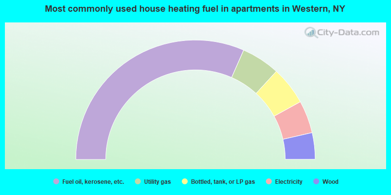
- 73.8%Fuel oil, kerosene, etc.
- 9.2%Wood
- 8.4%Bottled, tank, or LP gas
- 4.1%Electricity
- 3.8%Utility gas
- 0.6%Other fuel
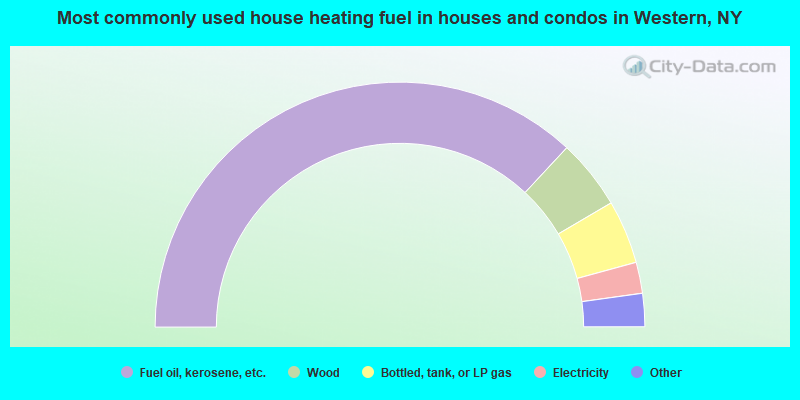
- 63.2%Fuel oil, kerosene, etc.
- 10.4%Utility gas
- 10.4%Bottled, tank, or LP gas
- 8.8%Electricity
- 7.2%Wood
Western compared to New York state average:
- Median house value significantly below state average.
- Unemployed percentage significantly below state average.
- Black race population percentage significantly below state average.
- Hispanic race population percentage significantly below state average.
- Foreign-born population percentage significantly below state average.
- Renting percentage significantly below state average.
- Length of stay since moving in significantly above state average.
- Number of rooms per house significantly below state average.
- House age significantly below state average.
- Percentage of population with a bachelor's degree or higher below state average.