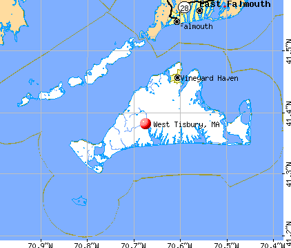
West Tisbury, Massachusetts
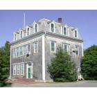
West Tisbury: West Tisbury Town Hall

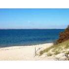
West Tisbury: Long Point Beach - On the south side of the Island
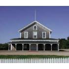
West Tisbury: The Grange Hall - also known as the Old Agricultural Hall
West Tisbury: Lambert's Cove Beach - This is the Town owned beach on the north side of the Island.
- add
your
Submit your own pictures of this town and show them to the world
- OSM Map
- General Map
- Google Map
- MSN Map
Population change since 2000: +11.1%
 |
| Males: 1,308 | |
| Females: 1,432 |
| Median resident age: | 46.9 years |
| Massachusetts median age: | 39.2 years |
Zip codes: 02575.
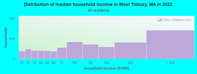
| West Tisbury: | $108,342 |
| MA: | $94,488 |
Estimated per capita income in 2022: $71,983 (it was $31,021 in 2000)
West Tisbury town income, earnings, and wages data
Estimated median house or condo value in 2022: over $1,000,000 (it was $366,700 in 2000)
| West Tisbury: | over $1,000,000 |
| MA: | $534,700 |
Mean prices in 2022: all housing units: over $1,000,000; detached houses: over $1,000,000; townhouses or other attached units: over $1,000,000; in 2-unit structures: $912,859; in 3-to-4-unit structures: $934,263
Detailed information about poverty and poor residents in West Tisbury, MA


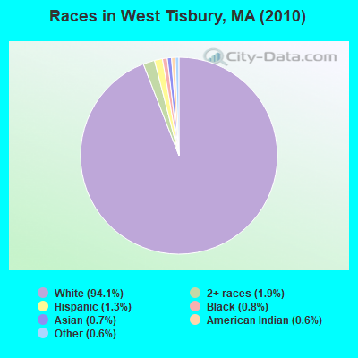
- 2,57894.1%White alone
- 511.9%Two or more races
- 351.3%Hispanic
- 230.8%Black alone
- 190.7%Asian alone
- 170.6%American Indian alone
- 160.6%Other race alone
- 10.04%Native Hawaiian and Other
Pacific Islander alone
Races in West Tisbury detailed stats: ancestries, foreign born residents, place of birth
According to our research of Massachusetts and other state lists, there was 1 registered sex offender living in West Tisbury, Massachusetts as of June 03, 2024.
The ratio of all residents to sex offenders in West Tisbury is 2,740 to 1.
The ratio of registered sex offenders to all residents in this city is lower than the state average.
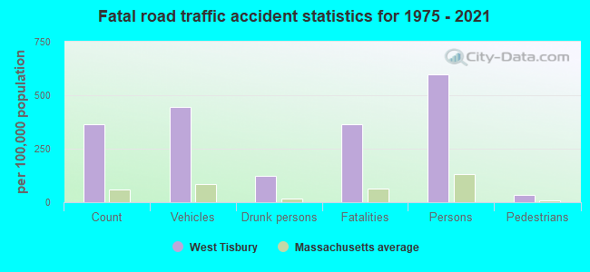
Type |
2009 |
2010 |
2011 |
2012 |
2013 |
2014 |
2015 |
2016 |
2017 |
2018 |
2019 |
2020 |
2021 |
2022 |
|---|---|---|---|---|---|---|---|---|---|---|---|---|---|---|
| Murders (per 100,000) | 0 (0.0) | 1 (36.5) | 0 (0.0) | 0 (0.0) | 0 (0.0) | 0 (0.0) | 0 (0.0) | 0 (0.0) | 0 (0.0) | 0 (0.0) | 0 (0.0) | 0 (0.0) | 0 (0.0) | 1 (26.6) |
| Rapes (per 100,000) | 1 (37.5) | 2 (73.0) | 0 (0.0) | 0 (0.0) | 0 (0.0) | 0 (0.0) | 0 (0.0) | 0 (0.0) | 2 (68.5) | 0 (0.0) | 1 (34.4) | 0 (0.0) | 0 (0.0) | 0 (0.0) |
| Robberies (per 100,000) | 0 (0.0) | 0 (0.0) | 0 (0.0) | 0 (0.0) | 0 (0.0) | 1 (34.4) | 0 (0.0) | 0 (0.0) | 0 (0.0) | 0 (0.0) | 0 (0.0) | 1 (34.3) | 0 (0.0) | 0 (0.0) |
| Assaults (per 100,000) | 3 (112.4) | 5 (182.5) | 2 (72.5) | 2 (71.4) | 1 (35.0) | 4 (137.6) | 4 (136.0) | 7 (239.2) | 7 (239.7) | 8 (274.0) | 6 (206.1) | 8 (274.1) | 14 (469.5) | 7 (186.3) |
| Burglaries (per 100,000) | 11 (412.3) | 14 (510.9) | 11 (399.0) | 4 (142.7) | 8 (280.1) | 8 (275.1) | 7 (237.9) | 9 (307.5) | 5 (171.2) | 2 (68.5) | 2 (68.7) | 2 (68.5) | 1 (33.5) | 3 (79.9) |
| Thefts (per 100,000) | 32 (1,199) | 12 (438.0) | 16 (580.3) | 13 (463.8) | 16 (560.2) | 14 (481.4) | 26 (883.8) | 8 (273.3) | 19 (650.7) | 20 (684.9) | 11 (377.9) | 13 (445.4) | 11 (368.9) | 6 (159.7) |
| Auto thefts (per 100,000) | 1 (37.5) | 3 (109.5) | 1 (36.3) | 0 (0.0) | 2 (70.0) | 2 (68.8) | 3 (102.0) | 2 (68.3) | 2 (68.5) | 1 (34.2) | 4 (137.4) | 0 (0.0) | 1 (33.5) | 1 (26.6) |
| Arson (per 100,000) | 0 (0.0) | 0 (0.0) | 0 (0.0) | 0 (0.0) | 0 (0.0) | 0 (0.0) | 0 (0.0) | 0 (0.0) | 0 (0.0) | 0 (0.0) | 0 (0.0) | 0 (0.0) | 0 (0.0) | 0 (0.0) |
| City-Data.com crime index | 132.3 | 229.9 | 68.6 | 42.8 | 54.6 | 81.8 | 87.4 | 85.8 | 146.2 | 89.7 | 99.6 | 87.7 | 113.7 | 104.6 |
The City-Data.com crime index weighs serious crimes and violent crimes more heavily. Higher means more crime, U.S. average is 246.1. It adjusts for the number of visitors and daily workers commuting into cities.
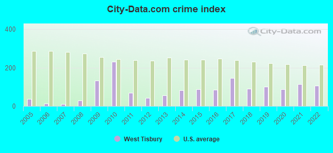
Crime rate in West Tisbury detailed stats: murders, rapes, robberies, assaults, burglaries, thefts, arson
Full-time law enforcement employees in 2020, including police officers: 10 (9 officers - 9 male; 0 female).
| Officers per 1,000 residents here: | 3.08 |
| Massachusetts average: | 2.59 |
 Recent articles from our blog. Our writers, many of them Ph.D. graduates or candidates, create easy-to-read articles on a wide variety of topics.

 | Big MA Ancestry Data Thread by Town (31 replies) |
| Martha’s Vinyard or Nantucket for vacation? (26 replies) |
| How Much Massachusetts Households Make Per Year: Census Data (37 replies) |
| Researching novel - cities for affluent college kids in Martha's Vineyard? (26 replies) |
| The Best Town Commons in Massachusetts (72 replies) |
| Moving to Martha's Vineyard all year long (30 replies) |
Latest news from West Tisbury, MA collected exclusively by city-data.com from local newspapers, TV, and radio stations
West Tisbury, MA City Guides:
Ancestries: English (26.7%), Irish (19.5%), German (11.8%), United States (11.3%), Italian (7.7%), French (6.9%).
Current Local Time: EST time zone
Incorporated in 1892
Elevation: 37 feet
Land area: 25.0 square miles.
Population density: 110 people per square mile (very low).
90 residents are foreign born (2.0% Europe, 0.6% Latin America, 0.4% Oceania, 0.4% North America).
| This town: | 3.6% |
| Massachusetts: | 12.2% |
| West Tisbury town: | 0.5% ($1,825) |
| Massachusetts: | 1.3% ($2,336) |
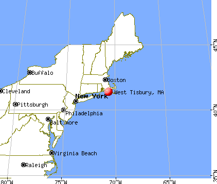
Nearest city with pop. 50,000+: New Bedford, MA  (22.9 miles , pop. 93,768).
Nearest city with pop. 200,000+: Boston, MA (67.9 miles , pop. 589,141).
Nearest city with pop. 1,000,000+: Queens, NY (171.6 miles , pop. 2,229,379).
Nearest cities:
), ), Latitude: 41.39 N, Longitude: 70.66 W
Area code commonly used in this area: 508

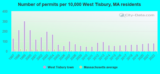
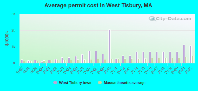
Single-family new house construction building permits:
- 2022: 20 buildings, average cost: $1,070,700
- 2021: 20 buildings, average cost: $1,126,300
- 2020: 19 buildings, average cost: $702,800
- 2019: 17 buildings, average cost: $702,800
- 2018: 17 buildings, average cost: $702,800
- 2017: 16 buildings, average cost: $702,800
- 2016: 15 buildings, average cost: $702,800
- 2015: 14 buildings, average cost: $702,800
- 2014: 15 buildings, average cost: $702,800
- 2013: 24 buildings, average cost: $457,100
- 2012: 22 buildings, average cost: $457,100
- 2011: 12 buildings, average cost: $277,700
- 2010: 12 buildings, average cost: $2,060,000
- 2009: 14 buildings, average cost: $562,100
- 2008: 18 buildings, average cost: $731,500
- 2007: 25 buildings, average cost: $731,500
- 2006: 14 buildings, average cost: $538,500
- 2005: 17 buildings, average cost: $417,500
- 2004: 42 buildings, average cost: $357,000
- 2003: 49 buildings, average cost: $358,500
- 2002: 35 buildings, average cost: $244,600
- 2001: 30 buildings, average cost: $195,500
- 2000: 53 buildings, average cost: $118,000
- 1999: 75 buildings, average cost: $209,100
- 1998: 53 buildings, average cost: $170,500
- 1997: 32 buildings, average cost: $213,800
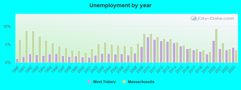
| Here: | 4.2% |
| Massachusetts: | 3.5% |
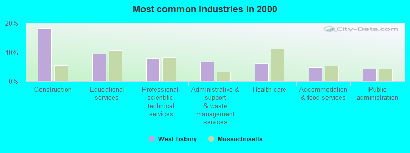
- Construction (18.3%)
- Educational services (9.5%)
- Professional, scientific, technical services (7.9%)
- Administrative & support & waste management services (6.7%)
- Health care (6.2%)
- Accommodation & food services (4.8%)
- Public administration (4.3%)
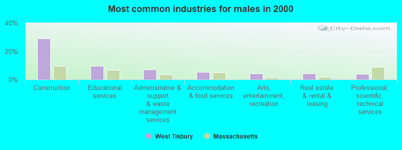
- Construction (29.0%)
- Educational services (9.5%)
- Administrative & support & waste management services (7.1%)
- Accommodation & food services (5.4%)
- Arts, entertainment, recreation (4.4%)
- Real estate & rental & leasing (4.1%)
- Professional, scientific, technical services (4.0%)
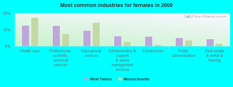
- Health care (12.7%)
- Professional, scientific, technical services (12.5%)
- Educational services (9.5%)
- Administrative & support & waste management services (6.3%)
- Construction (6.0%)
- Public administration (5.0%)
- Real estate & rental & leasing (4.4%)
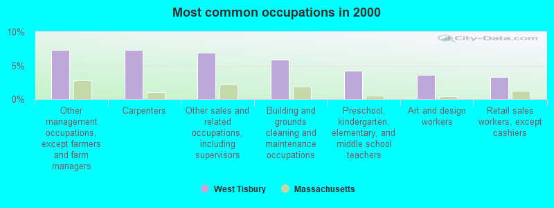
- Other management occupations, except farmers and farm managers (7.3%)
- Carpenters (7.3%)
- Other sales and related occupations, including supervisors (6.9%)
- Building and grounds cleaning and maintenance occupations (5.9%)
- Preschool, kindergarten, elementary, and middle school teachers (4.2%)
- Art and design workers (3.6%)
- Retail sales workers, except cashiers (3.3%)
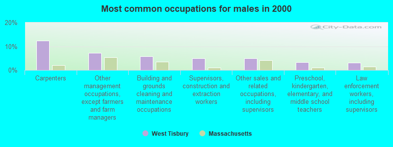
- Carpenters (12.3%)
- Other management occupations, except farmers and farm managers (7.1%)
- Building and grounds cleaning and maintenance occupations (5.8%)
- Supervisors, construction and extraction workers (5.0%)
- Other sales and related occupations, including supervisors (4.9%)
- Preschool, kindergarten, elementary, and middle school teachers (3.3%)
- Law enforcement workers, including supervisors (3.0%)
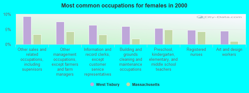
- Other sales and related occupations, including supervisors (9.3%)
- Other management occupations, except farmers and farm managers (7.5%)
- Information and record clerks, except customer service representatives (6.4%)
- Building and grounds cleaning and maintenance occupations (6.0%)
- Preschool, kindergarten, elementary, and middle school teachers (5.4%)
- Registered nurses (4.7%)
- Art and design workers (4.4%)
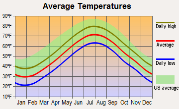
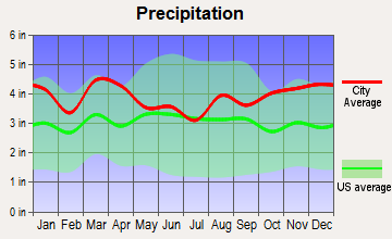
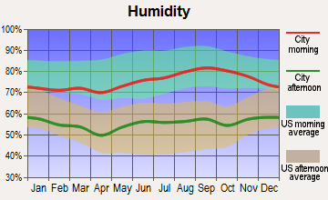
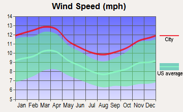
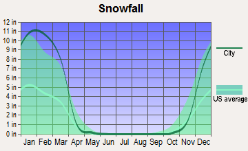
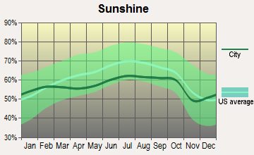
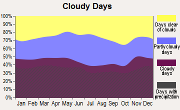
Average climate in West Tisbury, Massachusetts
Based on data reported by over 4,000 weather stations
(lower is better)
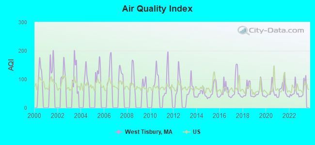
Air Quality Index (AQI) level in 2022 was 51.5. This is significantly better than average.
| City: | 51.5 |
| U.S.: | 72.6 |
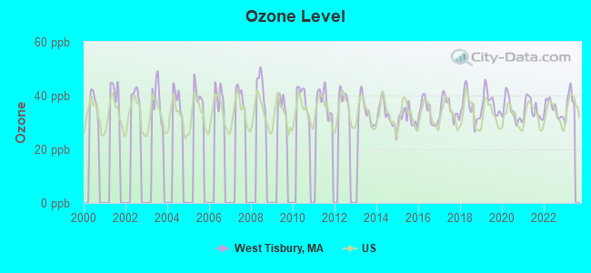
Ozone [ppb] level in 2022 was 34.9. This is about average. Closest monitor was 8.0 miles away from the city center.
| City: | 34.9 |
| U.S.: | 33.3 |
Earthquake activity:
West Tisbury-area historical earthquake activity is significantly above Massachusetts state average. It is 77% smaller than the overall U.S. average.On 8/22/1992 at 12:20:32, a magnitude 4.8 (4.8 MB, 3.8 MS, 4.7 LG, Depth: 6.2 mi, Class: Light, Intensity: IV - V) earthquake occurred 159.3 miles away from West Tisbury center
On 10/7/1983 at 10:18:46, a magnitude 5.3 (5.1 MB, 5.3 LG, 5.1 ML, Class: Moderate, Intensity: VI - VII) earthquake occurred 257.7 miles away from the city center
On 4/20/2002 at 10:50:47, a magnitude 5.3 (5.3 ML, Depth: 3.0 mi) earthquake occurred 264.9 miles away from West Tisbury center
On 10/16/2012 at 23:12:25, a magnitude 4.7 (4.7 ML, Depth: 10.0 mi) earthquake occurred 152.4 miles away from the city center
On 1/19/1982 at 00:14:42, a magnitude 4.7 (4.5 MB, 4.7 MD, 4.5 LG) earthquake occurred 153.4 miles away from the city center
On 4/20/2002 at 10:50:47, a magnitude 5.2 (5.2 MB, 4.2 MS, 5.2 MW, 5.0 MW) earthquake occurred 264.1 miles away from West Tisbury center
Magnitude types: regional Lg-wave magnitude (LG), body-wave magnitude (MB), duration magnitude (MD), local magnitude (ML), surface-wave magnitude (MS), moment magnitude (MW)
Natural disasters:
The number of natural disasters in Dukes County (19) is greater than the US average (15).Major Disasters (Presidential) Declared: 11
Emergencies Declared: 7
Causes of natural disasters: Hurricanes: 7, Floods: 4, Storms: 4, Snowstorms: 3, Blizzards: 2, Snows: 2, Winter Storms: 2, Snowfall: 1, Tropical Storm: 1, Wind: 1, Other: 1 (Note: some incidents may be assigned to more than one category).
Hospitals and medical centers near West Tisbury:
- BARNSTABLE COUNTY HOSPITAL (Hospital, about 5 miles away; POCASSET, MA)
- CAPE COD AND ISLANDS MENTAL HEALTH CENTER (Hospital, about 5 miles away; POCASSET, MA)
- COLONIAL CARE CERTIFIED, INC (Home Health Center, about 11 miles away; FALMOUTH, MA)
- FALMOUTH NURSING HOME (Nursing Home, about 12 miles away; FALMOUTH, MA)
- ROYAL NURSING CENTER, LLC (Nursing Home, about 12 miles away; FALMOUTH, MA)
- FALMOUTH CARE AND REHABILITATION CENTER (Nursing Home, about 12 miles away; FALMOUTH, MA)
- VNA OF UPPER CAPE COD INC (Home Health Center, about 12 miles away; FALMOUTH, MA)
Colleges/universities with over 2000 students nearest to West Tisbury:
- University of Massachusetts-Dartmouth (about 25 miles; North Dartmouth, MA; Full-time enrollment: 7,545)
- Cape Cod Community College (about 27 miles; West Barnstable, MA; FT enrollment: 2,491)
- Bristol Community College (about 33 miles; Fall River, MA; FT enrollment: 5,707)
- Salve Regina University (about 34 miles; Newport, RI; FT enrollment: 2,349)
- Roger Williams University (about 36 miles; Bristol, RI; FT enrollment: 4,375)
- Bridgewater State University (about 45 miles; Bridgewater, MA; FT enrollment: 9,802)
- University of Rhode Island (about 46 miles; Kingston, RI; FT enrollment: 14,656)
Public high school in West Tisbury:
- MARTHA'S VINEYARD CHARTER SCHOOL (Students: 159, Location: 424 STATE ROAD, Grades: KG-12, Charter school)
Public elementary/middle school in West Tisbury:
- WEST TISBURY ELEMENTARY (Students: 277, Location: 401 OLD COUNTY ROAD, Grades: PK-8)
Points of interest:
Notable locations in West Tisbury: Martha's Vineyard Aero Light (A), Martha's Vineyard Public Charter School Library (B), American Youth Hostel (C), Joshua Slocum House (D), West Tisbury Public Library (E). Display/hide their locations on the map
Churches in West Tisbury include: Island Christian Church (A), Mayhew Chapel (B), Lamberts Cove Church (C). Display/hide their locations on the map
Cemeteries: West Tisbury Village Cemetery (1), Lamberts Cove Cemetery (2), Christiantown Memorial Cemetery (3). Display/hide their locations on the map
Lakes, reservoirs, and swamps: Fresh Pond (A), Old House Pond (B), Grey Pond (C), Lily Pond (D), James Pond (E), Duarte Ponds (F), Doggetts Pond (G), Tisbury Great Pond (H). Display/hide their locations on the map
Streams, rivers, and creeks: Blackwater Brook (A), Mill Brook (B), Witch Brook (C), Tiasquam River (D). Display/hide their locations on the map
Beach: Lamberts Cove Beach (A). Display/hide its location on the map
Hotel: Blue Goose (91 Old Courthouse Road) (1). Display/hide its approximate location on the map
Birthplace of: Rufus P. Spalding - Politician, Ryen Russillo - Radio journalist.
| This town: | 2.3 people |
| Massachusetts: | 2.5 people |
| This town: | 61.2% |
| Whole state: | 63.0% |
| This town: | 9.3% |
| Whole state: | 7.0% |
Likely homosexual households (counted as self-reported same-sex unmarried-partner households)
- Lesbian couples: 1.3% of all households
- Gay men: 0.5% of all households
| This town: | 2.4% |
| Whole state: | 9.3% |
| This town: | 0.5% |
| Whole state: | 4.4% |
Banks with branches in West Tisbury (2011 data):
- Martha's Vineyard Savings Bank: West Tisbury Branch at 490 State Road, branch established on 1998/12/15. Info updated 2007/11/16: Bank assets: $526.2 mil, Deposits: $431.2 mil, headquarters in Edgartown, MA, positive income, Mortgage Lending Specialization, 8 total offices
For population 15 years and over in West Tisbury:
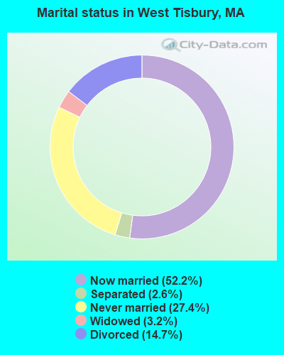
- Never married: 27.4%
- Now married: 52.2%
- Separated: 2.6%
- Widowed: 3.2%
- Divorced: 14.7%
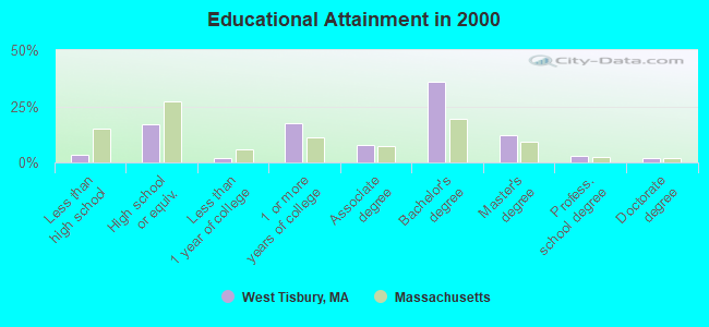
For population 25 years and over in West Tisbury:
- High school or higher: 96.5%
- Bachelor's degree or higher: 53.0%
- Graduate or professional degree: 17.1%
- Unemployed: 2.0%
- Mean travel time to work (commute): 18.9 minutes
| Here: | 8.6 |
| Massachusetts average: | 13.1 |
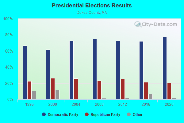
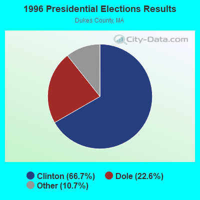
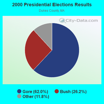
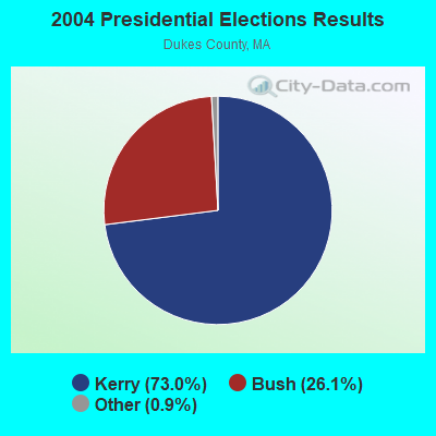
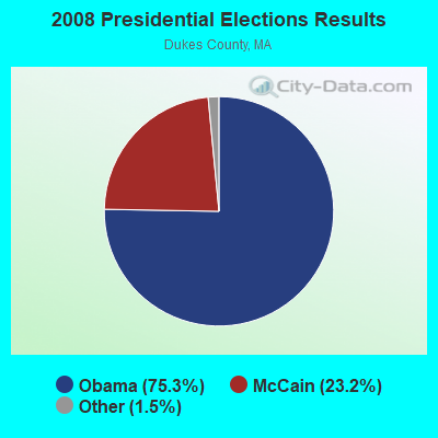
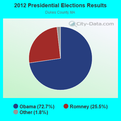
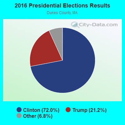
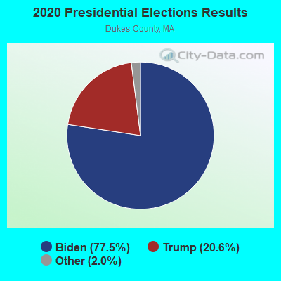
Graphs represent county-level data. Detailed 2008 Election Results
Religion statistics for West Tisbury, MA (based on Dukes County data)
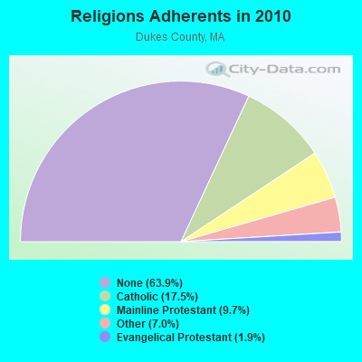
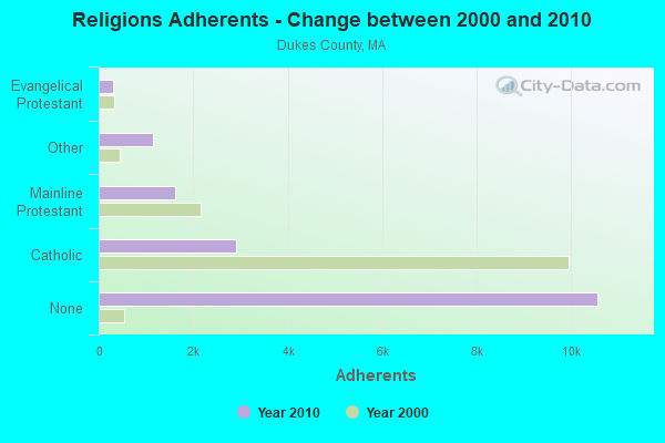
| Religion | Adherents | Congregations |
|---|---|---|
| Catholic | 2,896 | 1 |
| Mainline Protestant | 1,610 | 12 |
| Other | 1,157 | 6 |
| Evangelical Protestant | 310 | 3 |
| None | 10,562 | - |
Food Environment Statistics:
| Dukes County: | 8.41 / 10,000 pop. |
| Massachusetts: | 1.98 / 10,000 pop. |
| Here: | 1.94 / 10,000 pop. |
| Massachusetts: | 2.22 / 10,000 pop. |
| This county: | 1.94 / 10,000 pop. |
| Massachusetts: | 1.77 / 10,000 pop. |
| Dukes County: | 35.59 / 10,000 pop. |
| Massachusetts: | 8.76 / 10,000 pop. |
| Dukes County: | 8.1% |
| Massachusetts: | 8.1% |
| Dukes County: | 19.1% |
| Massachusetts: | 22.5% |
| This county: | 14.6% |
| Massachusetts: | 16.5% |
Businesses in West Tisbury, MA
- Budget Car Rental: 1
- FedEx: 1
- UPS: 1
Strongest AM radio stations in West Tisbury:
- WALE (990 AM; 50 kW; GREENVILLE, RI; Owner: NORTH AMERICAN BROADCASTING CO., INC.)
- WBZ (1030 AM; 50 kW; BOSTON, MA; Owner: INFINITY BROADCASTING OPERATIONS, INC.)
- WEEI (850 AM; 50 kW; BOSTON, MA; Owner: ENTERCOM BOSTON LICENSE, LLC)
- WRKO (680 AM; 50 kW; BOSTON, MA; Owner: ENTERCOM BOSTON LICENSE, LLC)
- WKOX (1200 AM; 50 kW; FRAMINGHAM, MA; Owner: CAPSTAR TX LIMITED PARTNERSHIP)
- WCRN (830 AM; 50 kW; WORCESTER, MA; Owner: CARTER BROADCASTING CORPORATION)
- WBSM (1420 AM; 5 kW; NEW BEDFORD, MA; Owner: CITADEL BROADCASTING COMPANY)
- WBIX (1060 AM; 40 kW; NATICK, MA; Owner: LANGER BROADCASTING CORPORATION)
- WWZN (1510 AM; 50 kW; BOSTON, MA; Owner: ROSE CITY RADIO CORPORATION)
- WAMG (890 AM; 25 kW; DEDHAM, MA; Owner: MEGA COMMUNICATIONS OF DEDHAM LICENSEE, LLC)
- WNNZ (640 AM; 50 kW; WESTFIELD, MA; Owner: CLEAR CHANNEL BROADCASTING LICENSES, INC.)
- WPRO (630 AM; 5 kW; PROVIDENCE, RI; Owner: CITADEL BROADCASTING COMPANY)
- WVNE (760 AM; daytime; 25 kW; LEICESTER, MA; Owner: BLOUNT MASSCOM, INC.)
Strongest FM radio stations in West Tisbury:
- WCAI (90.1 FM; WOODS HOLE, MA; Owner: WGBH EDUCATIONAL FOUNDATION)
- WMVY (92.7 FM; TISBURY, MA; Owner: ARITAUR COMMUNICATIONS, INC.)
- WCIB (101.9 FM; FALMOUTH, MA; Owner: QANTUM OF CAPE COD LICENSE COMPANY, LLC)
- WJFD-FM (97.3 FM; NEW BEDFORD, MA; Owner: EDMUND DINIS, TRUSTEE)
- WCTK (98.1 FM; NEW BEDFORD, MA; Owner: HALL COMMUNICATIONS, INC.)
- WTWV (101.1 FM; MASHPEE, MA; Owner: BOCH BROADCASTING, L.P.)
- WFPB-FM (91.9 FM; FALMOUTH, MA; Owner: UNIVERSITY OF MASSACHUSETTS)
- WPXC (102.9 FM; HYANNIS, MA; Owner: QANTUM OF CAPE COD LICENSE COMPANY, LLC)
- WKKB (100.3 FM; MIDDLETOWN, RI; Owner: CITADEL BROADCASTING COMPANY)
- WFHN (107.1 FM; FAIRHAVEN, MA; Owner: CITADEL BROADCASTING COMPANY)
- WRZE (96.3 FM; NANTUCKET, MA; Owner: QANTUM OF CAPE COD LICENSE COMPANY, LLC)
- WQRC (99.9 FM; BARNSTABLE, MA; Owner: SANDAB COMMUNICATION LTD. PNR/SHP II)
- WXTK (95.1 FM; WEST YARMOUTH, MA; Owner: BOCH BROADCASTING LTD. PARTNERSHIP)
- WSMU-FM (91.1 FM; NORTH DARTMOUTH, MA; Owner: UNIVERSITY OF MASSACHUSETTS)
TV broadcast stations around West Tisbury:
- WLWC (Channel 28; NEW BEDFORD, MA; Owner: C-28 FCC LICENSEE SUBSIDIARY, LLC)
- WDPX (Channel 58; VINEYARD HAVEN, MA; Owner: PAXSON BOSTON-68 LICENSE, INC.)
FCC Registered Cell Phone Towers:
1 (See the full list of FCC Registered Cell Phone Towers in West Tisbury)FCC Registered Antenna Towers:
54 (See the full list of FCC Registered Antenna Towers)FCC Registered Broadcast Land Mobile Towers:
7- Dukes County Airport (Lat: 41.392889 Lon: -70.616139), Call Sign: KQG404,
Assigned Frequencies: 158.940 MHz, 158.955 MHz, Grant Date: 01/16/2013, Expiration Date: 03/16/2023, Cancellation Date: 05/20/2023, Registrant: V-Comm Telecommunications Engineering, 2540 Us Highway 130, Suite 101, Cranbury, NJ 08512-3500, Phone: (609) 655-1200, Fax: (609) 409-1927, Email:
- Dukes County Airport (Lat: 41.392889 Lon: -70.616139), Call Sign: KCB860,
Assigned Frequencies: 155.520 MHz, 155.565 MHz, 155.640 MHz, 155.700 MHz, 158.850 MHz, 158.970 MHz, Grant Date: 05/04/2015, Expiration Date: 05/07/2025, Registrant: Barnstable County Sheriff\'s Office, 6000 Sheriff\'s Place, Bourne, MA 02532, Phone: (508) 563-4210, Fax: (508) 563-4288, Email:
- Off Sr (Lat: 41.383444 Lon: -70.836972), Call Sign: WNPH633, Licensee ID: L00016605,
Assigned Frequencies: 158.790 MHz, 158.850 MHz, 159.150 MHz, 158.865 MHz, 158.940 MHz, 158.955 MHz, Grant Date: 03/29/2005, Expiration Date: 06/12/2015, Cancellation Date: 08/15/2015, Registrant: City Of West Tisbury, West Tisbury, MA 02575, Phone: (508) 693-0020, Fax: (508) 696-0120, Email:
- Lat: 41.383444 Lon: -70.651111, Call Sign: WPWA914,
Assigned Frequencies: 152.390 MHz, 157.650 MHz, Grant Date: 10/01/2002, Expiration Date: 10/01/2012, Cancellation Date: 12/01/2012, Certifier: Seth V Macial, Registrant: Federal Licensing Inc, 1588 Faifield Road, Gettysburg, PA 17325, Phone: (717) 334-9262, Fax: (717) 334-6440
- Lat: 41.436278 Lon: -70.685861, Call Sign: WQUP360,
Assigned Frequencies: 451.637 MHz, 452.312 MHz, 456.637 MHz, 457.312 MHz, 452.512 MHz, Grant Date: 09/02/2014, Expiration Date: 09/02/2024, Certifier: Aileen Roberts, Registrant: Communications Usa, Inc., 2229 Enterprise Street, Escondido, CA 92029, Phone: (800) 338-1949, Fax: (858) 674-4273, Email:
- 454 State Rd. (Lat: 41.418028 Lon: -70.665194), Type: Bant, Structure height: 10 m, Overall height: 16 m, Call Sign: WRAR604,
Assigned Frequencies: 158.850 MHz, 159.150 MHz, Grant Date: 02/07/2018, Expiration Date: 02/07/2028, Certifier: Dougals Bardwell, Registrant: Bardwell Electronics, 17 Locust Lane, Vineyard Haven, MA 02568, Phone: (508) 693-1486, Fax: (508) 693-7291, Email:
- Lat: 41.395639 Lon: -70.677917, Call Sign: WRDC228,
Assigned Frequencies: 151.602 MHz, 152.982 MHz, 151.857 MHz, 151.895 MHz, 153.185 MHz, Grant Date: 03/25/2019, Expiration Date: 03/25/2029, Certifier: Ian Jochems, Registrant: Comtronics Corp, 1330 Furnace Brook Parkway, Quincy, MA 02169, Phone: (617) 770-0212, Email:
FCC Registered Microwave Towers:
4 (See the full list of FCC Registered Microwave Towers in this town)FCC Registered Maritime Coast & Aviation Ground Towers:
5 (See the full list of FCC Registered Maritime Coast & Aviation Ground Towers)FCC Registered Amateur Radio Licenses:
11 (See the full list of FCC Registered Amateur Radio Licenses in West Tisbury)FAA Registered Aircraft:
1- Aircraft: CESSNA 172 (Category: Land, Seats: 4, Weight: Up to 12,499 Pounds, Speed: 105 mph), Engine: CONT MOTOR 0-300 SER (145 HP) (Reciprocating)
N-Number: 6969A, N6969A, N-6969A, Serial Number: 29069, Year manufactured: 1956, Airworthiness Date: 08/28/1956, Certificate Issue Date: 08/26/2008
Registrant (Individual): Robert E Heaphy, Po Box 995, West Tisbury, MA 02575
Deregistered: Cancel Date: 01/09/2019
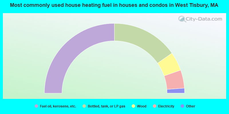
- 49.9%Fuel oil, kerosene, etc.
- 30.6%Bottled, tank, or LP gas
- 8.7%Wood
- 8.4%Electricity
- 1.3%Solar energy
- 0.5%Utility gas
- 0.5%Coal or coke
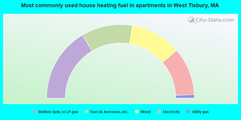
- 32.7%Bottled, tank, or LP gas
- 22.4%Fuel oil, kerosene, etc.
- 22.4%Wood
- 20.9%Electricity
- 1.5%Utility gas
West Tisbury compared to Massachusetts state average:
- Median house value above state average.
- Unemployed percentage significantly below state average.
- Black race population percentage significantly below state average.
- Hispanic race population percentage significantly below state average.
- Median age above state average.
- Foreign-born population percentage significantly below state average.
- Length of stay since moving in significantly above state average.
- Number of rooms per house significantly below state average.
- House age significantly below state average.
- Number of college students below state average.
- Percentage of population with a bachelor's degree or higher above state average.

|
|
Total of 24 patent applications in 2008-2024.