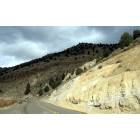
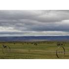
Warner Valley, Oregon
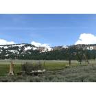
Warner Valley: Hwy 140...Is that a cow on the hill??
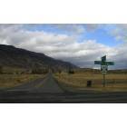
Warner Valley: Crossroads.....
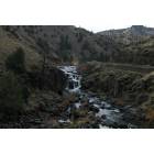
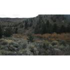
Warner Valley: Deep Creek Falls.....
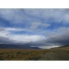
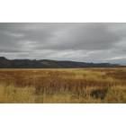
Warner Valley: Warner Valley.....
Warner Valley: In the Warner Mtns..
Warner Valley: Autumn.......
Warner Valley: Deep Creek in the fall ....Great trout fishing.....
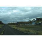
Warner Valley: Adel...
Warner Valley: Muleys.......
- add
your
Submit your own pictures of this place and show them to the world
- OSM Map
- General Map
- Google Map
- MSN Map

| Males: 136 | |
| Females: 118 |
| Median resident age: | 44.4 years |
| Oregon median age: | 36.3 years |
Zip code: 97637
| Warner Valley: | $57,157 |
| OR: | $75,657 |
Estimated per capita income in 2022: $31,757 (it was $17,155 in 2000)
Warner Valley CCD income, earnings, and wages data
Estimated median house or condo value in 2022: $380,518 (it was $131,800 in 2000)
| Warner Valley: | $380,518 |
| OR: | $475,600 |
Detailed information about poverty and poor residents in Warner Valley, OR
Compare current foreclosures near your location:
| Photo | Address | Area | Beds / Baths | Price | Details |
|---|---|---|---|---|---|

|
#1
N Rhodes St
Pretty Prairie, KS 67570
|
1,725 sq. feet
|
2 baths 4 beds |
show details | |

|
#2
W 21st St N
Cheney, KS 67025
|
3,190 sq. feet
|
3 baths 5 beds |
show details | |

|
#3
NE Waterloo Ave
Murdock, KS 67111
|
1,220 sq. feet
|
1 baths 3 beds |
show details | |

|
#4
E Arlington Rd
Haven, KS 67543
|
960 sq. feet
|
1 baths 2 beds |
show details | |

|
#5
S Daily Rd
Mount Hope, KS 67108
|
1,828 sq. feet
|
2 baths 2 beds |
show details | |

|
#6
E Winterset St
Goddard, KS 67052
|
816 sq. feet
|
1 baths 2 beds |
show details | |

|
#7
W 39th St S
Goddard, KS 67052
|
4,221 sq. feet
|
3 baths 3 beds |
show details | |

|
#8
E 4th Ave Apt 1
Cheney, KS 67025
|
- sq. feet
|
- baths - beds |
show details | |

|
#9
SE Viney Ave
Murdock, KS 67111
|
- sq. feet
|
- baths - beds |
show details | |

|
#10
W Main St
Mount Hope, KS 67108
|
- sq. feet
|
- baths - beds |
show details |
| Photo | Address | Area | Beds / Baths | Price | Details |
|---|---|---|---|---|---|

|
#11
N 189th Cir W
Colwich, KS 67030
|
- sq. feet
|
- baths - beds |
show details | |

|
#12
N Main St
Goddard, KS 67052
|
- sq. feet
|
- baths - beds |
show details | |

|
#13
Martens Ct
Goddard, KS 67052
|
- sq. feet
|
- baths - beds |
show details | |

|
#14
W Maple St Lot D
Goddard, KS 67052
|
- sq. feet
|
- baths - beds |
show details | |

|
#15
S 339th St W
Cheney, KS 67025
|
- sq. feet
|
- baths - beds |
show details | |

|
#16
E Casey Dr
Goddard, KS 67052
|
- sq. feet
|
- baths - beds |
show details | |

|
Check over 1 million property listings on Foreclosure.com!
|
browse all offers | |||

- 25296.2%White alone
- 51.9%Hispanic
- 31.1%Two or more races
- 10.4%American Indian alone
- 10.4%Asian alone

Races in Warner Valley detailed stats: ancestries, foreign born residents, place of birth
 Recent articles from our blog. Our writers, many of them Ph.D. graduates or candidates, create easy-to-read articles on a wide variety of topics.
Current Local Time: PST time zone
Land area: 2734.6 square miles.
Population density: 0.09 people per square mile (very low).

| Warner Valley CCD: | 0.3% ($375) |
| Oregon: | 1.2% ($1,687) |
Nearest city with pop. 50,000+: Bend, OR  (131.5 miles , pop. 52,029).
Nearest city with pop. 200,000+: Northwest Clackamas, OR (244.4 miles , pop. 224,220).
Nearest city with pop. 1,000,000+: Los Angeles, CA (584.4 miles , pop. 3,694,820).
Nearest cities:
Latitude: 42.45 N, Longitude: 119.91 W
Area code commonly used in this area: 541


| Here: | 5.6% |
| Oregon: | 3.9% |

- Agriculture, forestry, fishing & hunting (43.8%)
- Educational services (13.9%)
- Public administration (11.1%)
- Construction (10.4%)
- Health care (6.9%)
- Professional, scientific, technical services (4.9%)
- Truck transportation (2.8%)

- Agriculture, forestry, fishing & hunting (57.5%)
- Construction (18.8%)
- Public administration (6.2%)
- Truck transportation (5.0%)
- Professional, scientific, technical services (5.0%)
- Educational services (5.0%)
- Health care (2.5%)

- Agriculture, forestry, fishing & hunting (26.6%)
- Educational services (25.0%)
- Public administration (17.2%)
- Health care (12.5%)
- Department & other general merchandise stores (4.7%)
- Finance & insurance (4.7%)
- Professional, scientific, technical services (4.7%)

- Farmers and farm managers (20.8%)
- Agricultural workers, including supervisors (19.4%)
- Life and physical scientists (6.2%)
- Preschool, kindergarten, elementary, and middle school teachers (5.6%)
- Other construction workers and helpers (4.2%)
- Media and communications workers (3.5%)
- Bookkeeping, accounting, and auditing clerks (3.5%)

- Farmers and farm managers (27.5%)
- Agricultural workers, including supervisors (27.5%)
- Other construction workers and helpers (7.5%)
- Construction traders workers except carpenters, electricians, painters, plumbers, and construction laborers (6.2%)
- Teachers, secondary school (5.0%)
- Driver/sales workers and truck drivers (5.0%)
- Other production occupations, including supervisors (3.8%)

- Life and physical scientists (14.1%)
- Preschool, kindergarten, elementary, and middle school teachers (12.5%)
- Farmers and farm managers (12.5%)
- Agricultural workers, including supervisors (9.4%)
- Bookkeeping, accounting, and auditing clerks (7.8%)
- Building and grounds cleaning and maintenance occupations (6.2%)
- Postsecondary teachers (4.7%)
Average climate in Warner Valley, Oregon
Based on data reported by over 4,000 weather stations


Earthquake activity:
Warner Valley-area historical earthquake activity is significantly above Oregon state average. It is 3462% greater than the overall U.S. average.On 10/3/1915 at 06:52:48, a magnitude 7.6 (7.6 UK, Class: Major, Intensity: VIII - XII) earthquake occurred 183.9 miles away from the city center
On 4/18/1906 at 13:12:21, a magnitude 7.9 (7.9 UK) earthquake occurred 348.2 miles away from the city center, causing $524,000,000 total damage
On 1/31/1922 at 13:17:28, a magnitude 7.6 (7.6 UK) earthquake occurred 315.8 miles away from the city center
On 11/8/1980 at 10:27:34, a magnitude 7.2 (6.2 MB, 7.2 MS, 7.2 MW, 7.0 ML) earthquake occurred 244.4 miles away from Warner Valley center
On 4/25/1992 at 18:06:04, a magnitude 7.2 (6.3 MB, 7.1 MS, 7.2 MW, 7.1 MW, Depth: 9.4 mi) earthquake occurred 259.8 miles away from the city center, causing $75,000,000 total damage
On 12/16/1954 at 11:07:12, a magnitude 7.0 (7.0 UK) earthquake occurred 246.0 miles away from Warner Valley center
Magnitude types: body-wave magnitude (MB), local magnitude (ML), surface-wave magnitude (MS), moment magnitude (MW)
Natural disasters:
The number of natural disasters in Lake County (8) is smaller than the US average (15).Major Disasters (Presidential) Declared: 4
Emergencies Declared: 2
Causes of natural disasters: Fires: 2, Floods: 2, Winter Storms: 2, Drought: 1, Heavy Rain: 1, Hurricane: 1, Wind: 1, Other: 1 (Note: some incidents may be assigned to more than one category).
Colleges/universities with over 2000 students nearest to Warner Valley:
- Oregon Institute of Technology (about 97 miles; Klamath Falls, OR; Full-time enrollment: 2,900)
- Central Oregon Community College (about 134 miles; Bend, OR; FT enrollment: 5,217)
- Southern Oregon University (about 144 miles; Ashland, OR; FT enrollment: 4,650)
- Shasta College (about 178 miles; Redding, CA; FT enrollment: 5,645)
- Rogue Community College (about 178 miles; Grants Pass, OR; FT enrollment: 3,600)
- Treasure Valley Community College (about 184 miles; Ontario, OR; FT enrollment: 2,055)
- Northwest Nazarene University (about 187 miles; Nampa, ID; FT enrollment: 2,290)
Points of interest:
Notable locations in Warner Valley: M C Ranch (A), Loveless Homestead (B), Hickey Ranch (C), Johnson Ranch (D), Haw Cabin (E), Mud Creek Recreation Site (F), Gunkel Ranch (G), Frakes Cabin (H), Flook Ranch (I), Fitzgerald Ranch (J), Barnhardy (K), Drake Peak Lookout (L), Doherty Ranch (M), Crump Ranch (N), Shirk Ranch (O), Sage Hen Crossing (P), Deboy Ranch (Q), Chandler Cabin (R), Chambers Ranch (S), Walker Trailhead (T). Display/hide their locations on the map
Lakes, reservoirs, and swamps: Greaser Lake (A), High Rim Waterhole (B), Hitching Post Water Hole (C), Horsehead Lake (D), Jack Lake (E), Link Lake (F), Little Skookum Lake (G), Long Lake (H). Display/hide their locations on the map
Streams, rivers, and creeks: South Fork Bridge Creek (A), Fort Creek (B), Fifteenmile Creek (C), Drake Creek (D), Mud Creek (E), Deppy Creek (F), Deep Creek (G), Cressler Creek (H), Crane Creek (I). Display/hide their locations on the map
Parks in Warner Valley include: Langslet Monument Rest Area (1), Abert Rim Viewpoint (2), Abert Rim Historical Marker (3), Egan County Park (4). Display/hide their locations on the map
| This place: | 2.0 people |
| Oregon: | 2.5 people |
| This place: | 57.7% |
| Whole state: | 63.4% |
| This place: | 8.9% |
| Whole state: | 8.0% |
Likely homosexual households (counted as self-reported same-sex unmarried-partner households)
- Lesbian couples: 0.8% of all households
- Gay men: 0.0% of all households
| This place: | 15.5% |
| Whole state: | 11.6% |
| This place: | 2.6% |
| Whole state: | 5.0% |
For population 15 years and over in Warner Valley:

- Never married: 20.0%
- Now married: 66.0%
- Separated: 0.0%
- Widowed: 3.3%
- Divorced: 10.7%
For population 25 years and over in Warner Valley:
- High school or higher: 89.7%
- Bachelor's degree or higher: 27.6%
- Graduate or professional degree: 5.4%
- Unemployed: 4.0%
- Mean travel time to work (commute): 14.0 minutes


| Here: | 8.9 |
| Oregon average: | 11.5 |
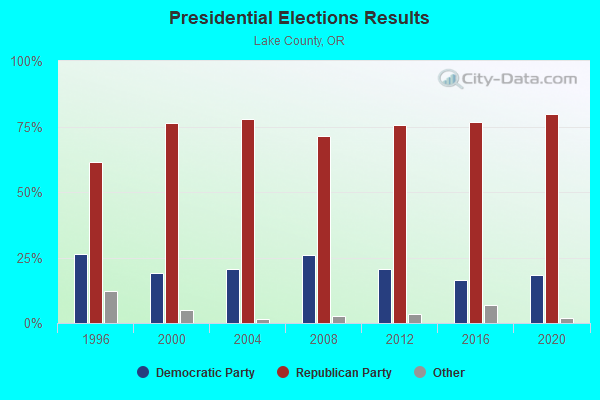
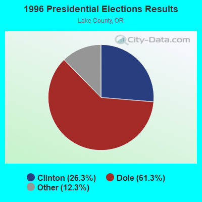
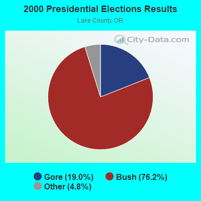
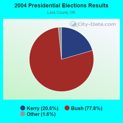
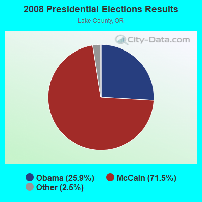
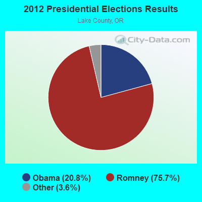
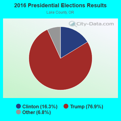
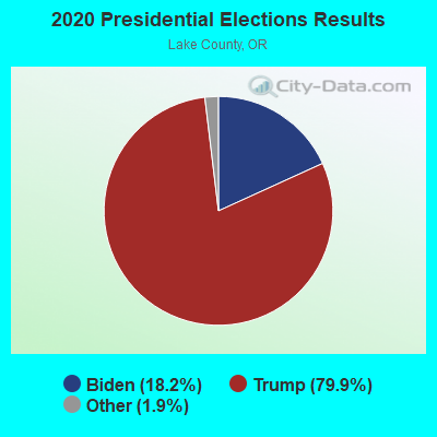
Graphs represent county-level data. Detailed 2008 Election Results
Religion statistics for Warner Valley, OR (based on Lake County data)
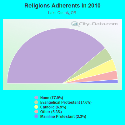
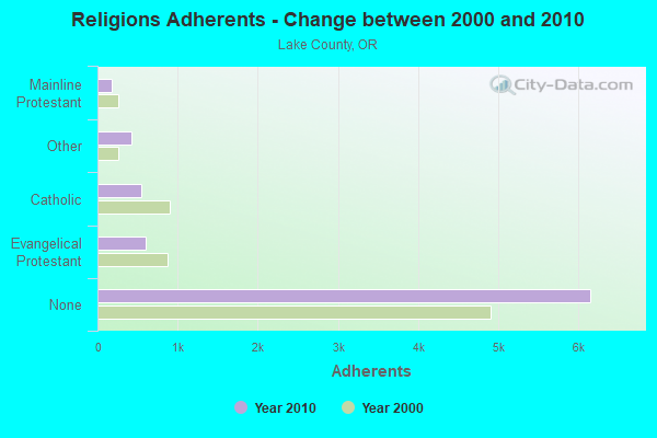
| Religion | Adherents | Congregations |
|---|---|---|
| Evangelical Protestant | 597 | 14 |
| Catholic | 548 | 5 |
| Other | 417 | 3 |
| Mainline Protestant | 183 | 4 |
| None | 6,150 | - |
Food Environment Statistics:
| Here: | 4.14 / 10,000 pop. |
| Oregon: | 2.03 / 10,000 pop. |
| Lake County: | 1.38 / 10,000 pop. |
| Oregon: | 2.01 / 10,000 pop. |
| Lake County: | 4.14 / 10,000 pop. |
| Oregon: | 1.69 / 10,000 pop. |
| This county: | 12.42 / 10,000 pop. |
| State: | 9.93 / 10,000 pop. |
| Here: | 8.7% |
| Oregon: | 7.4% |
| Lake County: | 24.5% |
| Oregon: | 25.6% |
| This county: | 11.0% |
| Oregon: | 14.2% |
Strongest AM radio stations in Warner Valley:
- KBOI (670 AM; 50 kW; BOISE, ID; Owner: CITADEL BROADCASTING COMPANY)
- KKOH (780 AM; 50 kW; RENO, NV; Owner: CITADEL BROADCASTING COMPANY)
- KPOJ (620 AM; 50 kW; PORTLAND, OR; Owner: CITICASTERS LICENSES, L.P.)
- KPNW (1120 AM; 50 kW; EUGENE, OR; Owner: CAPSTAR TX LIMITED PARTNERSHIP)
- KCFJ (570 AM; 5 kW; ALTURAS, CA; Owner: EDI MEDIA, INC.)
- KXL (750 AM; 50 kW; PORTLAND, OR; Owner: ROSE CITY RADIO CORPORATION)
- KWEI (1260 AM; 50 kW; WEISER, ID; Owner: TREASURE VALLEY BROADCASTING CO.)
- KGRV (700 AM; 25 kW; WINSTON, OR; Owner: PACIFIC CASCADE COMMUNICATIONS CORP.)
- KQIK (1230 AM; 1 kW; LAKEVIEW, OR; Owner: CLAUSE CHARITABLE REMAINDER TRUST)
- KDUN (1030 AM; 50 kW; REEDSPORT, OR; Owner: PAMPLIN BROADCASTING-OREGON, INC.)
- KPAM (860 AM; 50 kW; TROUTDALE, OR; Owner: PAMPLIN BROADCASTING-OREGON, INC.)
- KTMT (580 AM; 10 kW; ASHLAND, OR; Owner: MAPLETON COMMUNICATIONS, LLC)
- KOTK (1080 AM; 50 kW; PORTLAND, OR; Owner: FISHER BROADCASTING - PORTLAND RADIO, L.L.C.)
Strongest FM radio stations in Warner Valley:
- KQIK-FM (93.5 FM; LAKEVIEW, OR; Owner: CLAUSE CHARITABLE REMAINDER TRUST)
- KKRB (106.9 FM; KLAMATH FALLS, OR; Owner: WYNNE BROADCASTING COMPANY, INC.)
- KLCR (95.3 FM; LAKEVIEW, OR; Owner: WOODROW MICHAEL WARREN)

- 52.6%Fuel oil, kerosene, etc.
- 18.4%Electricity
- 17.1%Bottled, tank, or LP gas
- 11.8%Wood

- 35.3%Fuel oil, kerosene, etc.
- 32.4%Electricity
- 23.5%Wood
- 8.8%Bottled, tank, or LP gas
Warner Valley compared to Oregon state average:
- Unemployed percentage significantly below state average.
- Black race population percentage significantly below state average.
- Hispanic race population percentage significantly below state average.
- Median age above state average.
- Foreign-born population percentage significantly below state average.
- Length of stay since moving in significantly above state average.
- Number of rooms per house significantly below state average.
- House age significantly below state average.
- Number of college students significantly below state average.
Warner Valley on our top lists:
- #28 on the list of "Top 100 cities with largest land areas"
- #64 on the list of "Top 101 larger cities with the lowest real estate taxes percentage (population 50,000+)"