Wahkiakus, Washington
Submit your own pictures of this place and show them to the world
- OSM Map
- General Map
- Google Map
- MSN Map

| Males: 2,257 | |
| Females: 2,275 |
| Median resident age: | 40.7 years |
| Washington median age: | 35.3 years |
Zip code: 98635
| Wahkiakus: | $69,300 |
| WA: | $91,306 |
Estimated per capita income in 2022: $40,577 (it was $16,568 in 2000)
Wahkiakus CCD income, earnings, and wages data
Estimated median house or condo value in 2022: $375,289 (it was $98,500 in 2000)
| Wahkiakus: | $375,289 |
| WA: | $569,500 |
Mean prices in 2022: all housing units: $494,782; detached houses: $520,850; townhouses or other attached units: $911,498; mobile homes: $309,069
Detailed information about poverty and poor residents in Wahkiakus, WA
Compare current foreclosures near Wahkiakus, WA:
| Photo | Address | Area | Beds / Baths | Price | Details |
|---|---|---|---|---|---|

|
#1
5th Ave
Dallesport, WA 98617
|
- sq. feet
|
2 baths 3 beds |
show details | |

|
#2
W 4th St
The Dalles, OR 97058
|
2,949 sq. feet
|
4 baths 5 beds |
show details | |

|
#3
E 10th St
The Dalles, OR 97058
|
1,700 sq. feet
|
2 baths 6 beds |
show details | |

|
#4
W Burgen St
Goldendale, WA 98620
|
- sq. feet
|
2 baths 4 beds |
show details | |

|
#5
Steele Rd
The Dalles, OR 97058
|
1,981 sq. feet
|
2 baths 2 beds |
show details | |

|
#6
W 3rd St
The Dalles, OR 97058
|
1,740 sq. feet
|
2 baths 4 beds |
show details | |

|
#7
Mount Hood St
The Dalles, OR 97058
|
957 sq. feet
|
2 baths 3 beds |
show details | |

|
#8
W 9th St
The Dalles, OR 97058
|
1,366 sq. feet
|
1 baths 4 beds |
show details | |

|
#9
E 8th St
The Dalles, OR 97058
|
2,176 sq. feet
|
1 baths 3 beds |
show details | |

|
#10
W Scenic Dr
The Dalles, OR 97058
|
2,466 sq. feet
|
2 baths 4 beds |
show details |
| Photo | Address | Area | Beds / Baths | Price | Details |
|---|---|---|---|---|---|

|
#11
E 10th St
The Dalles, OR 97058
|
1,083 sq. feet
|
1 baths 3 beds |
show details | |

|
#12
E 10th St
The Dalles, OR 97058
|
600 sq. feet
|
1 baths 1 beds |
show details | |

|
#13
3rd Ave Unit 68
Mosier, OR 97040
|
- sq. feet
|
2 baths 2 beds |
show details | |

|
#14
W 2nd St Apt 3
The Dalles, OR 97058
|
- sq. feet
|
1 baths 2 beds |
show details | |

|
#15
Chenoweth Rd Unit A-31
The Dalles, OR 97058
|
- sq. feet
|
- baths - beds |
show details | |

|
#16
Ericksen Way
The Dalles, OR 97058
|
- sq. feet
|
- baths - beds |
show details | |

|
#17
E 8th St
The Dalles, OR 97058
|
- sq. feet
|
- baths - beds |
show details | |

|
#18
E 10th St
The Dalles, OR 97058
|
- sq. feet
|
- baths - beds |
show details | |

|
#19
W 10th St Unit 45
The Dalles, OR 97058
|
- sq. feet
|
- baths - beds |
show details | |

|
#20
W 12th St
The Dalles, OR 97058
|
- sq. feet
|
- baths - beds |
show details |
| Photo | Address | Area | Beds / Baths | Price | Details |
|---|---|---|---|---|---|

|
#21
1/2 Washington St
The Dalles, OR 97058
|
- sq. feet
|
- baths - beds |
show details | |

|
#22
Veterans Dr, C O Oregon Veterns Home
The Dalles, OR 97058
|
- sq. feet
|
- baths - beds |
show details | |

|
#23
W 7th St Apt 23
The Dalles, OR 97058
|
- sq. feet
|
- baths - beds |
show details | |

|
#24
Pomona St Apt A
The Dalles, OR 97058
|
- sq. feet
|
- baths - beds |
show details | |

|
#25
Pomona St Apt B
The Dalles, OR 97058
|
- sq. feet
|
- baths - beds |
show details | |

|
#26
Cherry Heights Rd
The Dalles, OR 97058
|
- sq. feet
|
- baths - beds |
show details | |

|
#27
N Elm St
Bingen, WA 98605
|
- sq. feet
|
- baths - beds |
show details | |

|
#28
Foster Ct
Goldendale, WA 98620
|
- sq. feet
|
- baths - beds |
show details | |

|
Check over 1 million property listings on Foreclosure.com!
|
browse all offers | |||

- 3,77887.2%White alone
- 1683.9%American Indian alone
- 1693.9%Hispanic
- 1443.3%Two or more races
- 531.2%Asian alone
- 110.3%Other race alone
- 60.1%Black alone
- 20.05%Native Hawaiian and Other
Pacific Islander alone

Races in Wahkiakus detailed stats: ancestries, foreign born residents, place of birth
 Recent articles from our blog. Our writers, many of them Ph.D. graduates or candidates, create easy-to-read articles on a wide variety of topics.
Current Local Time: PST time zone
Land area: 350.4 square miles.
Population density: 13 people per square mile (very low).

| Wahkiakus CCD: | 0.8% ($821) |
| Washington: | 1.2% ($1,915) |
Nearest city with pop. 50,000+: Yakima, WA  (64.2 miles , pop. 71,845).
Nearest city with pop. 200,000+: Portland, OR (74.1 miles , pop. 529,121).
Nearest city with pop. 1,000,000+: Los Angeles, CA (821.6 miles , pop. 3,694,820).
Nearest cities:
), Latitude: 45.77 N, Longitude: 121.15 W
Area code commonly used in this area: 509


| Here: | 6.1% |
| Washington: | 4.6% |

- Educational services (11.3%)
- Construction (9.8%)
- Agriculture, forestry, fishing & hunting (8.9%)
- Accommodation & food services (6.8%)
- Metal & metal products (6.7%)
- Health care (6.6%)
- Food & beverage stores (3.4%)

- Construction (15.8%)
- Agriculture, forestry, fishing & hunting (13.6%)
- Metal & metal products (11.7%)
- Rail transportation (5.8%)
- Administrative & support & waste management services (5.1%)
- Educational services (4.6%)
- Utilities (3.8%)

- Educational services (18.9%)
- Health care (11.4%)
- Accommodation & food services (11.2%)
- Food & beverage stores (5.7%)
- Social assistance (4.5%)
- Public administration (4.2%)
- Professional, scientific, technical services (4.0%)

- Other management occupations, except farmers and farm managers (4.9%)
- Electrical equipment mechanics and other installation, maintenance, and repair workers, including supervisors (4.4%)
- Other production occupations, including supervisors (4.3%)
- Farmers and farm managers (4.0%)
- Driver/sales workers and truck drivers (3.4%)
- Agricultural workers, including supervisors (3.2%)
- Preschool, kindergarten, elementary, and middle school teachers (2.9%)

- Electrical equipment mechanics and other installation, maintenance, and repair workers, including supervisors (6.9%)
- Other production occupations, including supervisors (6.7%)
- Farmers and farm managers (5.9%)
- Driver/sales workers and truck drivers (5.9%)
- Other management occupations, except farmers and farm managers (5.4%)
- Agricultural workers, including supervisors (4.7%)
- Metal workers and plastic workers (4.6%)

- Preschool, kindergarten, elementary, and middle school teachers (5.8%)
- Other management occupations, except farmers and farm managers (4.4%)
- Cashiers (4.2%)
- Food and beverage serving workers, except waiters and waitresses (3.8%)
- Cooks and food preparation workers (3.5%)
- Other sales and related occupations, including supervisors (3.5%)
- Bookkeeping, accounting, and auditing clerks (3.3%)
Average climate in Wahkiakus, Washington
Based on data reported by over 4,000 weather stations


(lower is better)

Air Quality Index (AQI) level in 2021 was 58.0. This is better than average.
| City: | 58.0 |
| U.S.: | 72.6 |


Particulate Matter (PM2.5) [µg/m3] level in 2021 was 5.57. This is significantly better than average. Closest monitor was 12.1 miles away from the city center.
| City: | 5.57 |
| U.S.: | 8.11 |
Earthquake activity:
Wahkiakus-area historical earthquake activity is significantly above Washington state average. It is 1497% greater than the overall U.S. average.On 4/13/1949 at 19:55:42, a magnitude 7.0 (7.0 UK, Class: Major, Intensity: VIII - XII) earthquake occurred 120.6 miles away from the city center, causing $80,000,000 total damage
On 2/28/2001 at 18:54:32, a magnitude 6.8 (6.5 MB, 6.6 MS, 6.8 MW, Class: Strong, Intensity: VII - IX) earthquake occurred 113.7 miles away from the city center, causing $2,000,000,000 total damage and $305,000,000 insured losses
On 2/28/2001 at 18:54:32, a magnitude 6.8 (6.8 MD, Depth: 32.2 mi) earthquake occurred 121.2 miles away from Wahkiakus center
On 4/29/1965 at 15:28:43, a magnitude 6.6 (6.6 UK) earthquake occurred 120.6 miles away from the city center, causing $28,000,000 total damage
On 10/3/1915 at 06:52:48, a magnitude 7.6 (7.6 UK) earthquake occurred 408.6 miles away from Wahkiakus center
On 1/31/1922 at 13:17:28, a magnitude 7.6 (7.6 UK) earthquake occurred 415.0 miles away from Wahkiakus center
Magnitude types: body-wave magnitude (MB), duration magnitude (MD), surface-wave magnitude (MS), moment magnitude (MW)
Natural disasters:
The number of natural disasters in Klickitat County (19) is greater than the US average (15).Major Disasters (Presidential) Declared: 13
Emergencies Declared: 3
Causes of natural disasters: Floods: 8, Winter Storms: 6, Mudslides: 5, Fires: 4, Landslides: 4, Storms: 4, Snows: 3, Drought: 1, Heavy Rain: 1, Hurricane: 1, Volcanic Eruption: 1, Other: 1 (Note: some incidents may be assigned to more than one category).
Hospitals and medical centers near Wahkiakus:
- COLUMBIA BASIN CARE FACILITY (Nursing Home, about 12 miles away; THE DALLES, OR)
- VISITING HEALTH SERVICES (Home Health Center, about 12 miles away; THE DALLES, OR)
- OREGON VETERANS HOME (Nursing Home, about 12 miles away; THE DALLES, OR)
- THE DALLES HEALTH AND REHABILITATION CENTER (Nursing Home, about 13 miles away; THE DALLES, OR)
- MID-COLUMBIA MEDICAL CENTER Acute Care Hospitals (about 13 miles away; THE DALLES, OR)
- KLICKITAT VALLEY HLTH SVCS HH (Home Health Center, about 16 miles away; GOLDENDALE, WA)
- SKYLINE HOSPITAL Critical Access Hospitals (about 16 miles away; WHITE SALMON, WA)
Amtrak stations near Wahkiakus:
- 13 miles: WISHRAM (WEST END OF RAILROAD AVE.) . Services: partially wheelchair accessible, enclosed waiting area, public payphones, free short-term parking, free long-term parking.
- 13 miles: THE DALLES (201 E. FEDERAL ST.) - Bus Station . Services: enclosed waiting area, public restrooms, public payphones, free short-term parking, free long-term parking, call for taxi service.
- 16 miles: BINGEN-WHITE SALMON (BINGEN, FOOT OF WALNUT ST.) . Services: fully wheelchair accessible, free short-term parking, free long-term parking, call for taxi service.
Colleges/universities with over 2000 students nearest to Wahkiakus:
- Mt Hood Community College (about 63 miles; Gresham, OR; Full-time enrollment: 11,847)
- Yakima Valley Community College (about 64 miles; Yakima, WA; FT enrollment: 3,632)
- Clark College (about 74 miles; Vancouver, WA; FT enrollment: 9,330)
- Concordia University-Portland (about 74 miles; Portland, OR; FT enrollment: 3,996)
- Clackamas Community College (about 76 miles; Oregon City, OR; FT enrollment: 4,261)
- Portland State University (about 77 miles; Portland, OR; FT enrollment: 21,450)
- Lewis & Clark College (about 77 miles; Portland, OR; FT enrollment: 2,864)
Points of interest:
Notable locations in Wahkiakus: Fivemile Rapids Light (A), Hartland (B), Dallesdam (C), Avery (D), South Channel Range A (E), Hells Gate Range B (F), Hellsgate Range A (G), Spearfish Substation (H), Cold Spring Flat (I), Mile 7 Light (J), Threemile Rapids Light (K), Liberty Bond (L), Memaloose Island Light (M), Northdalles Station (N), Spearfish (O), Klickitat County Fire District 4 (P), Klickitat County Fire District 14 High Prairie (Q), Klickitat County Fire District 15 (R), Klickitat County Fire District 6 Dallesport / Murdock Fire Department (S), Klickitat County Fire Protection District 5 (T). Display/hide their locations on the map
Cemeteries: Lyle Cemetery (1), Hartland Cemetery (2), Centerville Cemetery (3), Wish-Ham Cemetery (4). Display/hide their locations on the map
Lakes and reservoirs: Fill Pond (A), Balch Lake (B), Waterhole (C), Chamberlain Lake (D), Little Spearfish Lake (E), Horsethief Lake (F), McCarty Pond (G), Spearfish Lake (H). Display/hide their locations on the map
Rivers and creeks: Eightmile Creek (A), Fivemile Creek (B), Klickitat River (C), Major Creek (D), Silvas Creek (E), Simmons Creek (F), Threemile Creek (G), Kuhnhausen Creek (H), Snyder Creek (I). Display/hide their locations on the map
Parks in Wahkiakus include: Avery Recreation Area (1), Horsethief Lake State Park (2), Hess Park (3), Recreation Area (4). Display/hide their locations on the map
| This place: | 2.6 people |
| Washington: | 2.5 people |
| This place: | 56.8% |
| Whole state: | 66.5% |
| This place: | 4.5% |
| Whole state: | 6.1% |
Likely homosexual households (counted as self-reported same-sex unmarried-partner households)
- Lesbian couples: 0.3% of all households
- Gay men: 0.2% of all households
| This place: | 16.9% |
| Whole state: | 10.6% |
| This place: | 5.5% |
| Whole state: | 4.6% |
13 people in nursing homes in 2000
For population 15 years and over in Wahkiakus:

- Never married: 16.5%
- Now married: 67.0%
- Separated: 1.5%
- Widowed: 6.8%
- Divorced: 9.8%
For population 25 years and over in Wahkiakus:
- High school or higher: 81.2%
- Bachelor's degree or higher: 13.6%
- Graduate or professional degree: 5.6%
- Unemployed: 11.9%
- Mean travel time to work (commute): 28.3 minutes


| Here: | 10.4 |
| Washington average: | 11.3 |
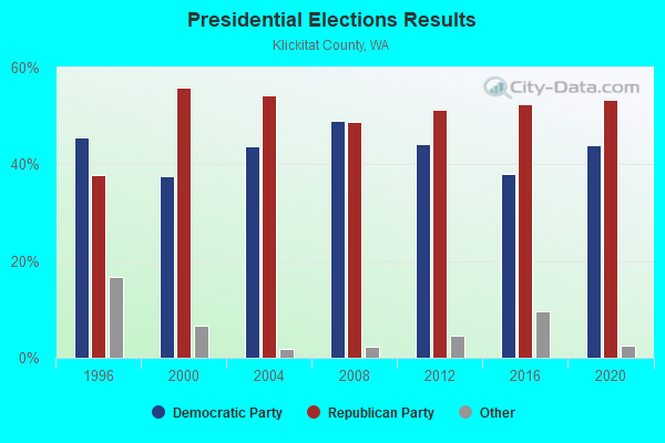
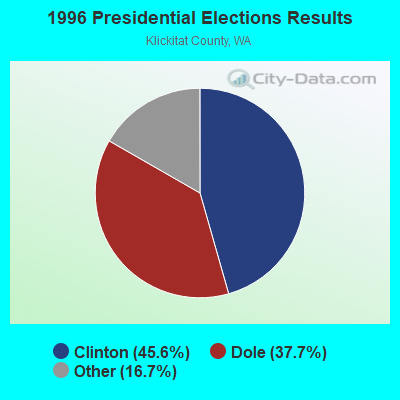
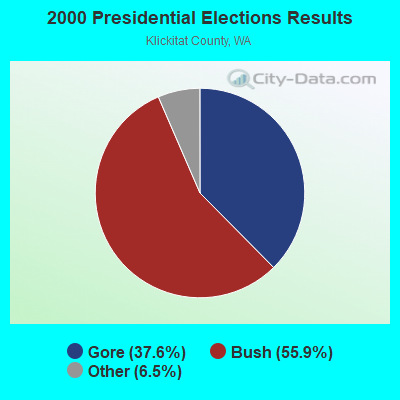
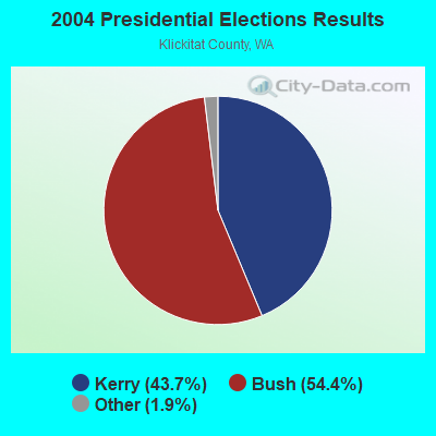
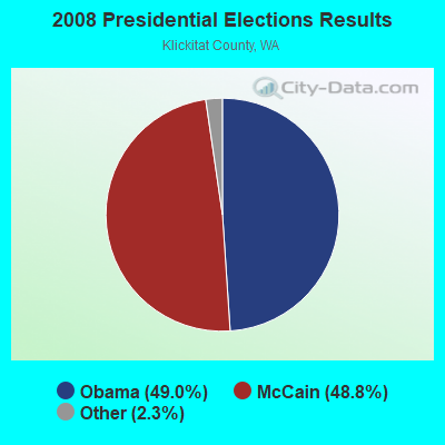
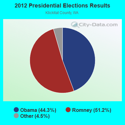
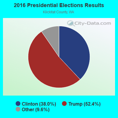
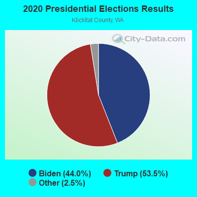
Graphs represent county-level data. Detailed 2008 Election Results
Religion statistics for Wahkiakus, WA (based on Klickitat County data)
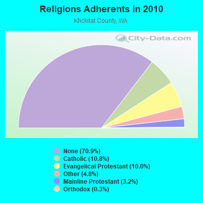
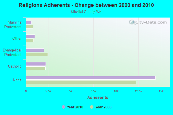
| Religion | Adherents | Congregations |
|---|---|---|
| Catholic | 2,200 | 2 |
| Evangelical Protestant | 2,026 | 23 |
| Other | 981 | 3 |
| Mainline Protestant | 654 | 9 |
| Orthodox | 55 | 1 |
| None | 14,402 | - |
Food Environment Statistics:
| Klickitat County: | 2.99 / 10,000 pop. |
| State: | 2.06 / 10,000 pop. |
| Klickitat County: | 0.50 / 10,000 pop. |
| Washington: | 1.18 / 10,000 pop. |
| Klickitat County: | 4.49 / 10,000 pop. |
| Washington: | 2.67 / 10,000 pop. |
| This county: | 6.48 / 10,000 pop. |
| Washington: | 8.26 / 10,000 pop. |
| Here: | 8.6% |
| State: | 7.7% |
| This county: | 26.0% |
| State: | 25.7% |
| This county: | 12.3% |
| State: | 13.9% |
Strongest AM radio stations in Wahkiakus:
- KODL (1440 AM; 5 kW; THE DALLES, OR; Owner: LARSON-WYNN, INC.)
- KPOJ (620 AM; 50 kW; PORTLAND, OR; Owner: CITICASTERS LICENSES, L.P.)
- KXL (750 AM; 50 kW; PORTLAND, OR; Owner: ROSE CITY RADIO CORPORATION)
- KPAM (860 AM; 50 kW; TROUTDALE, OR; Owner: PAMPLIN BROADCASTING-OREGON, INC.)
- KOTK (1080 AM; 50 kW; PORTLAND, OR; Owner: FISHER BROADCASTING - PORTLAND RADIO, L.L.C.)
- KEX (1190 AM; 50 kW; PORTLAND, OR; Owner: CITICASTERS LICENSES, L.P.)
- KKAD (1550 AM; 50 kW; VANCOUVER, WA; Owner: PAMPLIN BROADCASTING-WASHINGTON, INC)
- KKSN (1520 AM; 50 kW; OREGON CITY, OR; Owner: ENTERCOM PORTLAND LICENSE, LLC)
- KACI (1300 AM; 1 kW; THE DALLES, OR; Owner: COLUMBIA GORGE BROADCASTERS, INC.)
- KIRO (710 AM; 50 kW; SEATTLE, WA; Owner: ENTERCOM SEATTLE LICENSE, LLC)
- KTTH (770 AM; 50 kW; SEATTLE, WA; Owner: ENTERCOM SEATTLE LICENSE, LLC)
- KJR (950 AM; 50 kW; SEATTLE, WA)
- KGNW (820 AM; 50 kW; BURIEN-SEATTLE, WA; Owner: INSPIRATION MEDIA, INC.)
Strongest FM radio stations in Wahkiakus:
- KMCQ (104.5 FM; THE DALLES, OR; Owner: MID-COLUMBIA BROADCASTING, INC.)
- K215CR (90.9 FM; THE DALLES, OR; Owner: EDUCATIONAL MEDIA FOUNDATION)
- K256AC (99.1 FM; THE DALLES, OR; Owner: CATHOLIC BROADCASTING NORTHWEST, INC)
- KYYT (102.3 FM; GOLDENDALE, WA; Owner: HAYSTACK BROADCASTING, INC.)
- KQHR (90.1 FM; HOOD RIVER, OR; Owner: KBPS PUBLIC RADIO FOUNDATION)
- KMSW (92.7 FM; THE DALLES, OR; Owner: M.S.W. COMMUNICATIONS, L.L.C..)
- KBNO-FM (89.3 FM; WHITE SALMON, WA; Owner: WORLD RADIO NETWORK, INC.)
- KACI-FM (97.7 FM; THE DALLES, OR; Owner: COLUMBIA GORGE BROADCASTERS, INC.)
- KLVP-FM (88.7 FM; CHERRYVILLE, OR; Owner: EDUCATIONAL MEDIA FOUNDATION)
- KZRI (90.3 FM; WELCHES, OR; Owner: EDUCATIONAL MEDIA FOUNDATION)
- K218AZ (91.5 FM; THE DALLES, OR; Owner: OREGON PUBLIC BROADCASTING)
- K213DU (90.5 FM; GOLDENDALE/THE DALLE, WA; Owner: WASHINGTON STATE UNIVERSITY)
TV broadcast stations around Wahkiakus:
- K59EK (Channel 59; THE DALLES, OR; Owner: KING BROADCASTING COMPANY)
- K66AH (Channel 66; THE DALLES, ETC., OR; Owner: OREGON PUBLIC BROADCASTING)
- K61BX (Channel 61; THE DALLES, OR; Owner: FISHER BROADCASTING - PORTLAND TV, L.L.C.)
- K64BK (Channel 64; THE DALLES, OR; Owner: EMMIS TELEVISION LICENSE CORPORATION)
- K69AH (Channel 69; THE DALLES, OR; Owner: MEREDITH CORPORATION)
- K51EH (Channel 51; THE DALLES, OR; Owner: MEREDITH CORPORATION)

- 54.5%Electricity
- 29.2%Wood
- 6.5%Bottled, tank, or LP gas
- 6.4%Fuel oil, kerosene, etc.
- 2.7%Utility gas
- 0.6%Other fuel

- 58.6%Electricity
- 22.9%Wood
- 10.5%Utility gas
- 4.8%Fuel oil, kerosene, etc.
- 2.2%Bottled, tank, or LP gas
- 0.9%Other fuel
- 0.2%No fuel used
Wahkiakus compared to Washington state average:
- Median house value below state average.
- Black race population percentage significantly below state average.
- Hispanic race population percentage significantly below state average.
- Median age significantly above state average.
- Foreign-born population percentage significantly below state average.
- Renting percentage significantly below state average.
- Length of stay since moving in significantly above state average.
- Number of rooms per house significantly below state average.
- House age significantly below state average.
- Institutionalized population percentage significantly above state average.
- Number of college students below state average.
- Percentage of population with a bachelor's degree or higher below state average.