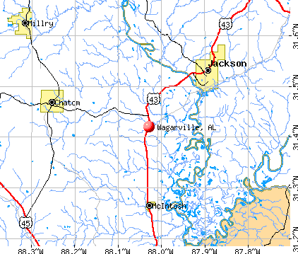
Wagarville, Alabama
Submit your own pictures of this place and show them to the world
- OSM Map
- General Map
- Google Map
- MSN Map
| Males: 1,623 | |
| Females: 1,654 |
| Median resident age: | 36.8 years |
| Alabama median age: | 35.8 years |
Zip code: 36585
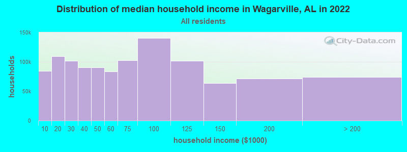
| Wagarville: | $62,818 |
| AL: | $59,674 |
Estimated per capita income in 2022: $33,452 (it was $15,919 in 2000)
Wagarville CCD income, earnings, and wages data
Estimated median house or condo value in 2022: $165,995 (it was $55,600 in 2000)
| Wagarville: | $165,995 |
| AL: | $200,900 |
Mean prices in 2022: all housing units: $157,305; detached houses: $200,063; mobile homes: $49,987
Detailed information about poverty and poor residents in Wagarville, AL
Compare current foreclosures near Wagarville, AL:
| Photo | Address | Area | Beds / Baths | Price | Details |
|---|---|---|---|---|---|

|
#1
L R P Rd
Wagarville, AL 36585
|
- sq. feet
|
- baths - beds |
show details | |

|
#2
Old Mobile St
Wagarville, AL 36585
|
- sq. feet
|
- baths - beds |
show details | |

|
#3
Vivian Ln
Wagarville, AL 36585
|
- sq. feet
|
- baths - beds |
show details | |

|
#4
Daugherty Ave
Mc Intosh, AL 36553
|
1 sq. feet
|
2 baths 4 beds |
show details | |

|
#5
Nichols Rd
Mc Intosh, AL 36553
|
1,742 sq. feet
|
2 baths 4 beds |
show details | |

|
#6
Palmer Cir
Leroy, AL 36548
|
- sq. feet
|
2 baths 4 beds |
show details | |

|
#7
Dawson Ave
Jackson, AL 36545
|
- sq. feet
|
- baths - beds |
show details | |

|
#8
E Central Ave # A4
Chatom, AL 36518
|
- sq. feet
|
- baths - beds |
show details | |

|
#9
Clemmons Cir, Apt 27
Chatom, AL 36518
|
- sq. feet
|
- baths - beds |
show details | |

|
#10
Highway 17
Tibbie, AL 36583
|
- sq. feet
|
- baths - beds |
show details |
| Photo | Address | Area | Beds / Baths | Price | Details |
|---|---|---|---|---|---|

|
#11
Shine Johnston Rd
Mc Intosh, AL 36553
|
- sq. feet
|
- baths - beds |
show details | |

|
#12
Robinson Cir
Jackson, AL 36545
|
- sq. feet
|
- baths - beds |
show details | |

|
#13
Dakota Rd
Jackson, AL 36545
|
- sq. feet
|
- baths - beds |
show details | |

|
#14
Woodie Ave
Jackson, AL 36545
|
- sq. feet
|
- baths - beds |
show details | |

|
#15
Frances Ave
Jackson, AL 36545
|
- sq. feet
|
- baths - beds |
show details | |

|
#16
Parker Cemetery Rd
Jackson, AL 36545
|
- sq. feet
|
- baths - beds |
show details | |

|
#17
Saint Elmo Rd
Jackson, AL 36545
|
- sq. feet
|
- baths - beds |
show details | |

|
#18
John Johnston Rd
Mc Intosh, AL 36553
|
- sq. feet
|
- baths - beds |
show details | |

|
#19
John Johnston Rd
Mc Intosh, AL 36553
|
- sq. feet
|
- baths - beds |
show details | |

|
#20
Highway 56
Chatom, AL 36518
|
- sq. feet
|
- baths - beds |
show details |
| Photo | Address | Area | Beds / Baths | Price | Details |
|---|---|---|---|---|---|

|
#21
Lang Rd
Mc Intosh, AL 36553
|
- sq. feet
|
- baths - beds |
show details | |

|
#22
Stanley Dr Apt 1h
Jackson, AL 36545
|
- sq. feet
|
- baths - beds |
show details | |

|
#23
Patton Rd
Mc Intosh, AL 36553
|
- sq. feet
|
- baths - beds |
show details | |

|
#24
Marshall Davis Rd
Mc Intosh, AL 36553
|
- sq. feet
|
- baths - beds |
show details | |

|
#25
Napoleon Thomas Rd
Mc Intosh, AL 36553
|
- sq. feet
|
- baths - beds |
show details | |

|
#26
Edgewood Dr
Jackson, AL 36545
|
- sq. feet
|
- baths - beds |
show details | |

|
#27
Walker Springs Rd
Jackson, AL 36545
|
- sq. feet
|
- baths - beds |
show details | |

|
#28
Jc Turner Dr
Chatom, AL 36518
|
- sq. feet
|
- baths - beds |
show details | |

|
#29
Michael Dr W
Jackson, AL 36545
|
- sq. feet
|
- baths - beds |
show details | |

|
#30
Winn Rd
Jackson, AL 36545
|
- sq. feet
|
- baths - beds |
show details |
| Photo | Address | Area | Beds / Baths | Price | Details |
|---|---|---|---|---|---|

|
#31
Arrowhead Rd
Jackson, AL 36545
|
- sq. feet
|
- baths - beds |
show details | |

|
#32
Winn Rd
Jackson, AL 36545
|
- sq. feet
|
- baths - beds |
show details | |

|
#33
Walker Springs Rd
Jackson, AL 36545
|
- sq. feet
|
- baths - beds |
show details | |

|
#34
Beaver Dam Rd
Chatom, AL 36518
|
- sq. feet
|
- baths - beds |
show details | |

|
#35
Saint Christopher Rd
Jackson, AL 36545
|
- sq. feet
|
- baths - beds |
show details | |

|
#36
Toddtown Rd
Grove Hill, AL 36451
|
- sq. feet
|
- baths - beds |
show details | |

|
#37
Bouregard Rd
Frankville, AL 36538
|
- sq. feet
|
- baths - beds |
show details | |

|
#38
Sunny Hill Rd
Jackson, AL 36545
|
- sq. feet
|
- baths - beds |
show details | |

|
#39
Perrys Chapel Rd
Gainestown, AL 36540
|
- sq. feet
|
- baths - beds |
show details | |

|
#40
Winn Rd
Jackson, AL 36545
|
- sq. feet
|
- baths - beds |
show details |
| Photo | Address | Area | Beds / Baths | Price | Details |
|---|---|---|---|---|---|

|
#41
Bryan Johnson Road
Gainestown, AL 36540
|
- sq. feet
|
- baths - beds |
show details | |

|
#42
Springbank Church Rd
Chatom, AL 36518
|
- sq. feet
|
- baths - beds |
show details | |

|
#43
Bryan Johnson Rd
Gainestown, AL 36540
|
- sq. feet
|
- baths - beds |
show details | |

|
#44
Deer Springs Rd
Jackson, AL 36545
|
- sq. feet
|
- baths - beds |
show details | |

|
#45
Powell Johnston Rd
Mc Intosh, AL 36553
|
- sq. feet
|
- baths - beds |
show details | |

|
#46
Bates Lake Road
Malcolm, AL 36556
|
- sq. feet
|
- baths - beds |
show details | |

|
#47
John Johnston Rd
Mc Intosh, AL 36553
|
- sq. feet
|
- baths - beds |
show details | |

|
#48
Walker Springs Rd
Grove Hill, AL 36451
|
- sq. feet
|
- baths - beds |
show details | |

|
#49
Old Saint Mathew Rd
Jackson, AL 36545
|
- sq. feet
|
- baths - beds |
show details | |

|
Check over 1 million property listings on Foreclosure.com!
|
browse all offers | |||

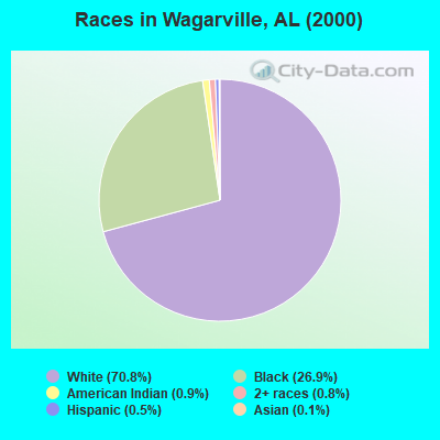
- 2,45370.8%White alone
- 93326.9%Black alone
- 310.9%American Indian alone
- 270.8%Two or more races
- 190.5%Hispanic
- 40.1%Asian alone
According to our research of Alabama and other state lists, there were 3 registered sex offenders living in Wagarville, Alabama as of May 31, 2024.
The ratio of all residents to sex offenders in Wagarville is 1,092 to 1.
The ratio of registered sex offenders to all residents in this city is much lower than the state average.
 Recent articles from our blog. Our writers, many of them Ph.D. graduates or candidates, create easy-to-read articles on a wide variety of topics.
Current Local Time: CST time zone
Elevation: 59 feet
Land area: 232.8 square miles.
Population density: 14 people per square mile (very low).

| Wagarville CCD: | 0.4% ($199) |
| Alabama: | 0.4% ($289) |
Nearest city with pop. 50,000+: Mobile, AL  (51.4 miles , pop. 198,915).
Nearest city with pop. 200,000+: Montgomery, AL (121.6 miles , pop. 201,568).
Nearest city with pop. 1,000,000+: Houston, TX (452.5 miles , pop. 1,953,631).
Nearest cities:
), ), ), ), Latitude: 31.42 N, Longitude: 88.03 W
Area code commonly used in this area: 251

| Here: | 3.0% |
| Alabama: | 2.6% |
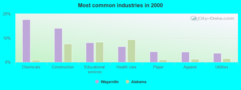
- Chemicals (17.6%)
- Construction (14.1%)
- Educational services (8.1%)
- Health care (6.5%)
- Paper (4.4%)
- Apparel (4.2%)
- Utilities (3.7%)
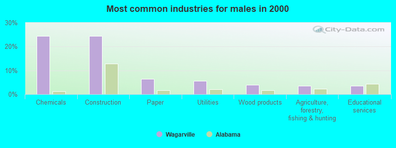
- Chemicals (24.5%)
- Construction (24.3%)
- Paper (6.4%)
- Utilities (5.5%)
- Wood products (3.9%)
- Agriculture, forestry, fishing & hunting (3.6%)
- Educational services (3.5%)
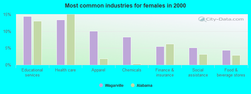
- Educational services (14.4%)
- Health care (13.4%)
- Apparel (10.0%)
- Chemicals (8.3%)
- Finance & insurance (5.5%)
- Social assistance (5.1%)
- Food & beverage stores (4.4%)
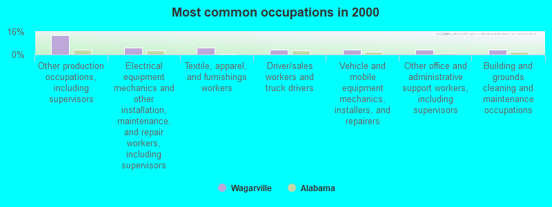
- Other production occupations, including supervisors (13.4%)
- Electrical equipment mechanics and other installation, maintenance, and repair workers, including supervisors (5.0%)
- Textile, apparel, and furnishings workers (4.9%)
- Driver/sales workers and truck drivers (3.5%)
- Vehicle and mobile equipment mechanics, installers, and repairers (3.4%)
- Other office and administrative support workers, including supervisors (3.3%)
- Building and grounds cleaning and maintenance occupations (3.3%)
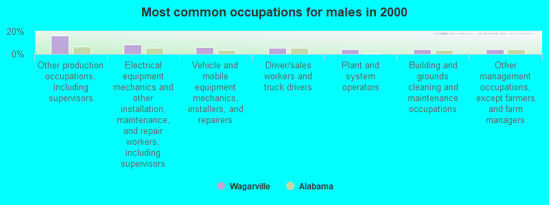
- Other production occupations, including supervisors (16.6%)
- Electrical equipment mechanics and other installation, maintenance, and repair workers, including supervisors (8.6%)
- Vehicle and mobile equipment mechanics, installers, and repairers (5.9%)
- Driver/sales workers and truck drivers (5.3%)
- Plant and system operators (4.5%)
- Building and grounds cleaning and maintenance occupations (4.1%)
- Other management occupations, except farmers and farm managers (4.0%)
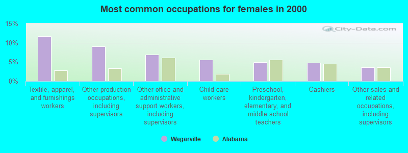
- Textile, apparel, and furnishings workers (11.6%)
- Other production occupations, including supervisors (9.0%)
- Other office and administrative support workers, including supervisors (6.9%)
- Child care workers (5.6%)
- Preschool, kindergarten, elementary, and middle school teachers (4.9%)
- Cashiers (4.8%)
- Other sales and related occupations, including supervisors (3.5%)
Average climate in Wagarville, Alabama
Based on data reported by over 4,000 weather stations


Tornado activity:
Wagarville-area historical tornado activity is below Alabama state average. It is 35% greater than the overall U.S. average.
On 1/23/1953, a category F3 (max. wind speeds 158-206 mph) tornado 7.8 miles away from the Wagarville place center injured one person and caused between $5000 and $50,000 in damages.
On 3/24/1984, a category F3 tornado 9.0 miles away from the place center caused between $500,000 and $5,000,000 in damages.
Earthquake activity:
Wagarville-area historical earthquake activity is significantly above Alabama state average. It is 80% greater than the overall U.S. average.On 10/24/1997 at 08:35:17, a magnitude 4.9 (4.8 MB, 4.2 MS, 4.9 LG, Depth: 6.2 mi, Class: Light, Intensity: IV - V) earthquake occurred 49.3 miles away from the city center
On 1/18/1999 at 07:00:53, a magnitude 4.8 (4.8 MB, 4.0 LG, Depth: 0.6 mi) earthquake occurred 144.5 miles away from Wagarville center
On 11/7/2004 at 11:20:21, a magnitude 4.3 (4.3 MW, Depth: 3.1 mi) earthquake occurred 85.2 miles away from the city center
On 6/24/1975 at 11:11:36, a magnitude 4.5 (4.5 MB) earthquake occurred 159.4 miles away from Wagarville center
On 4/29/2003 at 08:59:39, a magnitude 4.9 (4.4 MB, 4.6 MW, 4.9 LG) earthquake occurred 254.1 miles away from the city center
On 7/16/1993 at 10:54:32, a magnitude 3.7 (3.7 LG, Depth: 3.1 mi, Class: Light, Intensity: II - III) earthquake occurred 29.1 miles away from the city center
Magnitude types: regional Lg-wave magnitude (LG), body-wave magnitude (MB), surface-wave magnitude (MS), moment magnitude (MW)
Natural disasters:
The number of natural disasters in Washington County (21) is greater than the US average (15).Major Disasters (Presidential) Declared: 11
Emergencies Declared: 7
Causes of natural disasters: Hurricanes: 10, Storms: 7, Floods: 6, Tornadoes: 6, Winds: 4, Drought: 1, Fire: 1, Snowfall: 1, Winter Storm: 1, Other: 1 (Note: some incidents may be assigned to more than one category).
Hospitals and medical centers near Wagarville:
- JACKSON MEDICAL CENTER HOME HEALTH (Home Health Center, about 11 miles away; JACKSON, AL)
- WASHINGTON COUNTY HOSPITAL Critical Access Hospitals (about 11 miles away; CHATOM, AL)
- WASHINGTON COUNTY NURSING HOME (Nursing Home, about 11 miles away; CHATOM, AL)
- HOMETOWN HOSPICE, INC (Hospital, about 11 miles away; JACKSON, AL)
- ASERACARE HOSPICE-JACKSON (Hospital, about 12 miles away; JACKSON, AL)
- JACKSON HEALTH CARE FACILITY (Nursing Home, about 12 miles away; JACKSON, AL)
- WASHINGTON COUNTY HOME CARE (Home Health Center, about 14 miles away; CHATOM, AL)
Colleges/universities with over 2000 students nearest to Wagarville:
- James H Faulkner State Community College (about 42 miles; Bay Minette, AL; Full-time enrollment: 3,703)
- Bishop State Community College (about 51 miles; Mobile, AL; FT enrollment: 2,822)
- University of South Alabama (about 51 miles; Mobile, AL; FT enrollment: 13,228)
- Jones County Junior College (about 71 miles; Ellisville, MS; FT enrollment: 3,942)
- William Carey University (about 76 miles; Hattiesburg, MS; FT enrollment: 3,510)
- The University of West Florida (about 78 miles; Pensacola, FL; FT enrollment: 10,240)
- Meridian Community College (about 78 miles; Meridian, MS; FT enrollment: 2,750)
Points of interest:
Notable locations in Wagarville: Harrells Quarters (A), Export Landing (B), Bassetts Field (C), Three Rivers (D), Oven Landing (E), Masons Lower Landing (F), Lowman Steam Plant (G), Washington County C and D Landfill (H), Upper Bassett Landing (I), Saint Stephens Volunteer Fire Department (J), Tombigbee Power Plant (K), Wagarville Volunteer Fire Department (L), Leroy Volunteer Fire Department (M), Tibbie Volunteer Fire Department (N), Leroy Volunteer Fire Department Station 2 (O). Display/hide their locations on the map
Churches in Wagarville include: Mount Stoney African Methodist Episcopal Zion Church (A), Howard Town Baptist Church (B), Hawthorn Road Church (C), Fairhope Baptist Church (D), Ebenezer Methodist Church (E), Cortelyou Baptist Church (F), Clearwater Church (G), Chalker Memorial United Methodist Church (H), Wagarville Baptist Church (I). Display/hide their locations on the map
Cemeteries: Crawford Cemetery (1), Old Saint Stephens Cemetery (2), Ebenezer Cemetery (3), Stoker Cemetery (4), Washington Cemetery (5), Wagarville Cemetery (6), Howard Town Cemetery (7). Display/hide their locations on the map
Lakes, reservoirs, and swamps: Flat Lake (A), Flag Lake (B), Fishing Lake (C), Three Rivers Lake (D), Monger Lake (E), Crane Pond (F), Bull Ridge Pond (G), Dunn Lake (H). Display/hide their locations on the map
Streams, rivers, and creeks: Titi Branch (A), Smiths Creek (B), Roberts Creek (C), Rattlesnake Branch (D), Mill Branch (E), Miles Creek (F), Long Branch (G), Litty Spring Branch (H), Bassetts Creek (I). Display/hide their locations on the map
Parks in Wagarville include: Alabama Bluegrass Music Park (1), Palmer Stadium (2). Display/hide their locations on the map
Hotel: Airway Motel (Highway 43) (1). Display/hide its approximate location on the map
Drinking water stations with addresses in Wagarville and their reported violations in the past:
WAGARVILLE WATER SYSTEM (Population served: 480, Purch groundwater):Past monitoring violations:
- One minor monitoring violation
| This place: | 2.6 people |
| Alabama: | 2.5 people |
| This place: | 74.7% |
| Whole state: | 67.8% |
| This place: | 3.6% |
| Whole state: | 4.7% |
Likely homosexual households (counted as self-reported same-sex unmarried-partner households)
- Lesbian couples: 0.2% of all households
- Gay men: 0.2% of all households
| This place: | 14.4% |
| Whole state: | 16.1% |
| This place: | 5.0% |
| Whole state: | 7.3% |
For population 15 years and over in Wagarville:
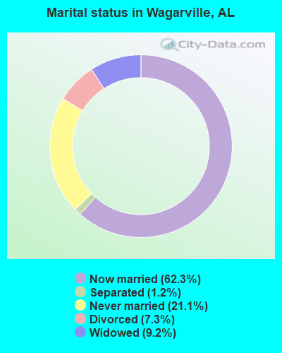
- Never married: 21.1%
- Now married: 62.3%
- Separated: 1.2%
- Widowed: 9.2%
- Divorced: 7.3%
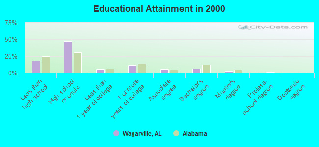
For population 25 years and over in Wagarville:
- High school or higher: 81.7%
- Bachelor's degree or higher: 10.5%
- Graduate or professional degree: 3.7%
- Unemployed: 9.0%
- Mean travel time to work (commute): 29.5 minutes
| Here: | 10.0 |
| Alabama average: | 13.2 |
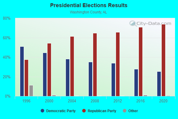
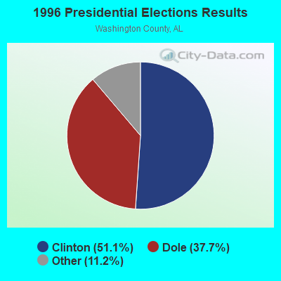
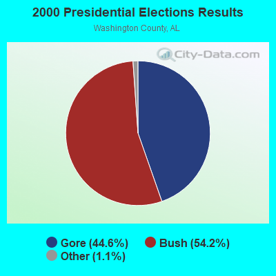


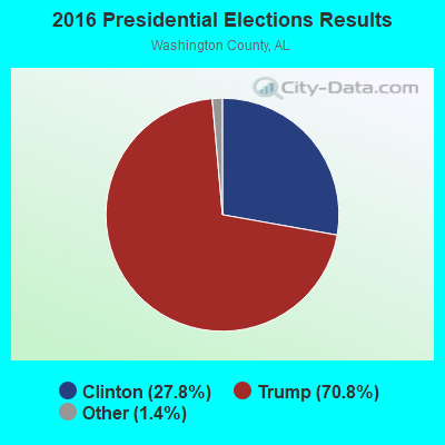
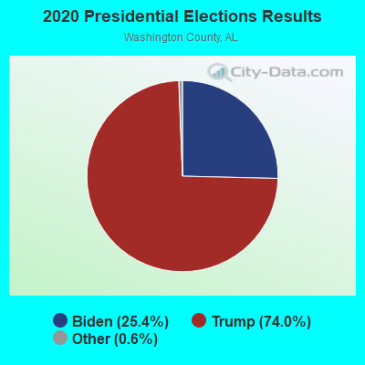
Graphs represent county-level data. Detailed 2008 Election Results
Religion statistics for Wagarville, AL (based on Washington County data)
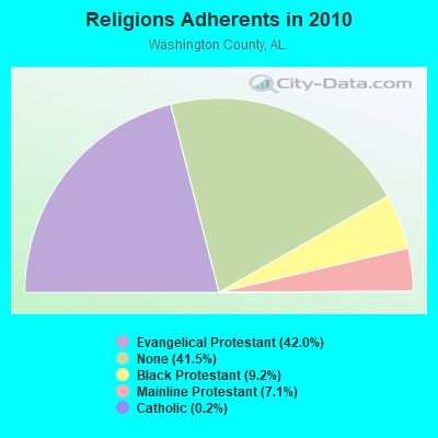
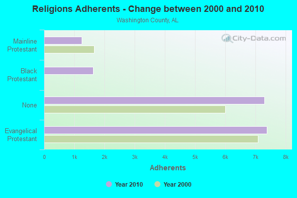
| Religion | Adherents | Congregations |
|---|---|---|
| Evangelical Protestant | 7,391 | 55 |
| Black Protestant | 1,621 | 12 |
| Mainline Protestant | 1,242 | 19 |
| Catholic | 30 | 2 |
| None | 7,297 | - |
Food Environment Statistics:
| Here: | 2.32 / 10,000 pop. |
| Alabama: | 1.89 / 10,000 pop. |
| Washington County: | 1.74 / 10,000 pop. |
| Alabama: | 0.65 / 10,000 pop. |
| This county: | 6.39 / 10,000 pop. |
| Alabama: | 6.32 / 10,000 pop. |
| Washington County: | 2.91 / 10,000 pop. |
| Alabama: | 5.75 / 10,000 pop. |
| Washington County: | 13.2% |
| Alabama: | 11.8% |
| Washington County: | 34.6% |
| Alabama: | 31.7% |
| This county: | 12.7% |
| Alabama: | 13.5% |
Strongest AM radio stations in Wagarville:
- WASG (550 AM; 25 kW; ATMORE, AL; Owner: 550 AM, INC)
- WNTM (710 AM; 10 kW; MOBILE, AL; Owner: CLEAR CHANNEL BROADCASTING LICENSES, INC.)
- WSJC (810 AM; 50 kW; MAGEE, MS; Owner: FAMILY TALK RADIO)
- WBHY (840 AM; daytime; 10 kW; MOBILE, AL; Owner: GOFORTH MEDIA, INC.)
- WBCA (1110 AM; daytime; 10 kW; BAY MINETTE, AL; Owner: SOUTHERN MEDIA COMMUNICATIONS, INC)
- WRJX (1230 AM; 1 kW; JACKSON, AL; Owner: CAPITAL ASSETS, INC)
- WDLT (660 AM; 10 kW; FAIRHOPE, AL; Owner: CUMULUS LICENSING CORP.)
- WYNI (930 AM; 5 kW; MONROEVILLE, AL; Owner: MCKISSICK ENTERPRISES)
- WJOX (690 AM; 50 kW; BIRMINGHAM, AL; Owner: CITADEL BROADCASTING COMPANY)
- WEBY (1330 AM; 25 kW; MILTON, FL; Owner: SPINNAKER LICENSE CORPORATION)
- WLPR (960 AM; 5 kW; PRICHARD, AL; Owner: GOFORTH MEDIA, INC.)
- WJNT (1180 AM; 50 kW; PEARL, MS; Owner: BUCHANAN BROADCASTING CO., INC.)
- WEEZ (890 AM; daytime; 10 kW; LAUREL, MS; Owner: CLEAR CHANNEL BROADCASTING LICENSES, INC.)
Strongest FM radio stations in Wagarville:
- WHNB (94.5 FM; JACKSON, AL; Owner: CAPITAL ASSETS, INC.)
- WMXC (99.9 FM; MOBILE, AL; Owner: CLEAR CHANNEL BROADCASTING LICENSES, INC.)
- WRKH (96.1 FM; MOBILE, AL; Owner: CLEAR CHANNEL BROADCASTING LICENSES, INC.)
- WABB-FM (97.5 FM; MOBILE, AL; Owner: WABB-FM, INC.)
- WBMH (106.1 FM; GROVE HILL, AL; Owner: CAPITAL ASSETS, INC.)
- WJDB-FM (95.5 FM; THOMASVILLE, AL; Owner: GRIFFIN BROADCASTING CORPORATION)
TV broadcast stations around Wagarville:
- WKRG-TV (Channel 5; MOBILE, AL; Owner: MEDIA GENERAL BROADCASTING OF SOUTH CAROLINA HOLDINGS, INC.)
- WEAR-TV (Channel 3; PENSACOLA, FL; Owner: WEAR LICENSEE, LLC)
- WRBM-LP (Channel 60; PRICHARD, AL; Owner: UPPER GULF COAST, L.L.C.)
- WMPV-TV (Channel 21; MOBILE, AL; Owner: TRINITY BROADCASTING NETWORK)
- WPMI (Channel 15; MOBILE, AL; Owner: CLEAR CHANNEL BROADCASTING LICENSES, INC.)
FCC Registered Antenna Towers:
22 (See the full list of FCC Registered Antenna Towers in Wagarville)FCC Registered Microwave Towers:
1- WAGARVILLE, Tarver Rd (023005) (Lat: 31.422111 Lon: -88.057750), Type: Gtower, Structure height: 101.8 m, Overall height: 104.2 m, Call Sign: WRCU966,
Assigned Frequencies: 11305.0 MHz, 11345.0 MHz, 11305.0 MHz, 11345.0 MHz, 11305.0 MHz, 11345.0 MHz, 11305.0 MHz, 11345.0 MHz, 11305.0 MHz, 11345.0 MHz... (+6 more), Grant Date: 02/05/2019, Expiration Date: 02/05/2029, Certifier: Larry F Butts, Registrant: Southern Company Services, 600 N. 18th St / Bin 5n-5409, Birmingham, AL 35203, Phone: (205) 257-7600, Fax: (205) 257-2134, Email:
FCC Registered Amateur Radio Licenses:
3- Call Sign: N5NPO, Licensee ID: L00314130, Grant Date: 04/12/2019, Expiration Date: 03/02/2029, Certifier: Norman E Knapp Jr, Registrant: Norman E Knapp Jr, 47 Jelks Road, Wagarville, AL 36585
- Call Sign: WD4HOI, Licensee ID: L01579331, Grant Date: 06/29/2010, Expiration Date: 06/29/2020, Cancellation Date: 06/30/2022, Registrant: Freddie L Mc Lain Sr, Wagarville, AL 36585
- Call Sign: KQ4IAT, Licensee ID: L02534130, Grant Date: 04/25/2023, Expiration Date: 04/25/2033, Certifier: Michael F Emmons, Registrant: Michael F Emmons, 308 Tarver Rd, Wagarville, AL 36585
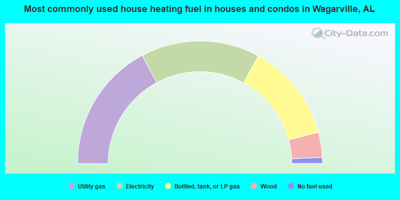
- 34.4%Utility gas
- 31.4%Electricity
- 26.0%Bottled, tank, or LP gas
- 6.6%Wood
- 1.6%No fuel used
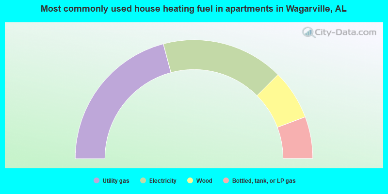
- 41.7%Utility gas
- 33.3%Electricity
- 13.6%Wood
- 11.4%Bottled, tank, or LP gas
Wagarville compared to Alabama state average:
- Hispanic race population percentage significantly below state average.
- Median age below state average.
- Foreign-born population percentage significantly below state average.
- Renting percentage significantly below state average.
- Length of stay since moving in significantly above state average.
- Number of rooms per house significantly below state average.
- House age significantly below state average.
- Number of college students below state average.
- Percentage of population with a bachelor's degree or higher below state average.