Volant, Pennsylvania
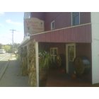
Volant: Winery in Volant, PA
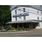
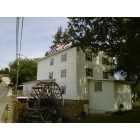
Volant: volant mill
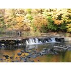
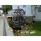
Volant: The falls at Volant - fall
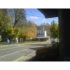
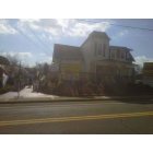
Volant: Volant, PA

Volant: Amish in Volant, PA
Volant: Volant, PA
Volant: Volant, PA
Volant: Volant, PA
- add
your
Submit your own pictures of this borough and show them to the world
- OSM Map
- General Map
- Google Map
- MSN Map

Population change since 2000: +10.6%
| Males: 65 | |
| Females: 60 |
| Median resident age: | 54.8 years |
| Pennsylvania median age: | 40.9 years |
Zip code: 16156
| Volant: | $65,854 |
| PA: | $71,798 |
Estimated per capita income in 2022: $40,006 (it was $17,642 in 2000)
Estimated median house or condo value in 2022: $131,277 (it was $70,800 in 2000)
| Volant: | $131,277 |
| PA: | $245,500 |
Mean prices in 2022: all housing units: $168,811; detached houses: $168,874
Median gross rent in 2022: $970.
Compare current foreclosures near Volant, PA:
| Photo | Address | Area | Beds / Baths | Price | Details |
|---|---|---|---|---|---|

|
#1
Arthur Dr
Volant, PA 16156
|
1,120 sq. feet
|
2 baths 3 beds |
show details | |

|
#2
State Route 956
Volant, PA 16156
|
1,323 sq. feet
|
2 baths 3 beds |
show details | |

|
#3
Gerber Rd
Volant, PA 16156
|
2,052 sq. feet
|
2 baths 4 beds |
show details | |

|
#4
Darlington Rd
Wampum, PA 16157
|
1,212 sq. feet
|
2 baths 3 beds |
$194,500
|
show details |

|
#5
Oak St
Sharpsville, PA 16150
|
1,333 sq. feet
|
2 baths 3 beds |
$279,900
|
show details |

|
#6
E Beaver St
Mercer, PA 16137
|
1,200 sq. feet
|
2 baths 3 beds |
$32,500
|
show details |

|
#7
Ryan Ave
New Castle, PA 16101
|
864 sq. feet
|
1 baths 3 beds |
$34,900
|
show details |

|
#8
Main St
West Middlesex, PA 16159
|
- sq. feet
|
1 baths 3 beds |
show details | |

|
#9
Erie St
Edinburg, PA 16116
|
1,114 sq. feet
|
1 baths 3 beds |
show details | |

|
#10
William Flynn Hwy
Slippery Rock, PA 16057
|
- sq. feet
|
1 baths 3 beds |
show details |
| Photo | Address | Area | Beds / Baths | Price | Details |
|---|---|---|---|---|---|

|
#11
Pollock Ave
New Castle, PA 16101
|
1,792 sq. feet
|
1 baths 3 beds |
show details | |

|
#12
Grant St
Fredonia, PA 16124
|
- sq. feet
|
1 baths 3 beds |
show details | |

|
#13
Chestnut St
New Castle, PA 16101
|
1,232 sq. feet
|
1 baths 2 beds |
show details | |

|
#14
Mitchell Rd
West Middlesex, PA 16159
|
- sq. feet
|
2 baths 3 beds |
show details | |

|
#15
Hewitt Rd
West Middlesex, PA 16159
|
1,785 sq. feet
|
1 baths 2 beds |
show details | |

|
#16
Elmwood Dr
Hubbard, OH 44425
|
1,528 sq. feet
|
1 baths 3 beds |
show details | |

|
#17
Neshannock Blvd
New Castle, PA 16101
|
1,440 sq. feet
|
2 baths 3 beds |
show details | |

|
#18
Falls Ave
New Castle, PA 16105
|
1,860 sq. feet
|
2 baths 4 beds |
show details | |

|
#19
E Maitland Ln
New Castle, PA 16105
|
1,482 sq. feet
|
2 baths 3 beds |
show details | |

|
#20
Porter Ave
Campbell, OH 44405
|
1,232 sq. feet
|
1 baths 3 beds |
show details |
| Photo | Address | Area | Beds / Baths | Price | Details |
|---|---|---|---|---|---|

|
#21
2nd Ave
Sharon, PA 16146
|
- sq. feet
|
1 baths 3 beds |
show details | |

|
#22
Struthers Liberty Rd
Campbell, OH 44405
|
808 sq. feet
|
1 baths 2 beds |
show details | |

|
#23
5th Ave
Sharon, PA 16146
|
- sq. feet
|
1 baths 3 beds |
show details | |

|
#24
W State St
Edinburg, PA 16116
|
1,598 sq. feet
|
1 baths 3 beds |
show details | |

|
#25
Woodbine Ave
Struthers, OH 44471
|
1,056 sq. feet
|
1 baths 3 beds |
show details | |

|
#26
Smiley St
Ellwood City, PA 16117
|
2,004 sq. feet
|
1 baths 3 beds |
show details | |

|
#27
Shady Ave
Sharon, PA 16146
|
- sq. feet
|
1 baths 3 beds |
show details | |

|
#28
Grace St
Hubbard, OH 44425
|
960 sq. feet
|
1 baths 3 beds |
show details | |

|
#29
Piccadilly St
Campbell, OH 44405
|
1,524 sq. feet
|
1 baths 2 beds |
show details | |

|
#30
Mercer Ave
Farrell, PA 16121
|
- sq. feet
|
3 baths 4 beds |
show details |
| Photo | Address | Area | Beds / Baths | Price | Details |
|---|---|---|---|---|---|

|
#31
Harmony Baptist Rd
New Castle, PA 16101
|
1,692 sq. feet
|
1 baths 4 beds |
show details | |

|
#32
Sunset Blvd
Ellwood City, PA 16117
|
1,001 sq. feet
|
1 baths 3 beds |
show details | |

|
#33
Edinburg Rd
New Castle, PA 16102
|
1,216 sq. feet
|
2 baths 3 beds |
show details | |

|
#34
Savannah Rd
New Castle, PA 16101
|
1,612 sq. feet
|
2 baths 2 beds |
show details | |

|
#35
Leeper Dr
New Castle, PA 16102
|
2,850 sq. feet
|
2 baths 3 beds |
show details | |

|
#36
Mohawk School Rd
Edinburg, PA 16116
|
1,034 sq. feet
|
1 baths 2 beds |
show details | |

|
#37
Clark Ln
Edinburg, PA 16116
|
1,456 sq. feet
|
2 baths 3 beds |
show details | |

|
#38
Sycamore Dr
Campbell, OH 44405
|
1,360 sq. feet
|
1 baths 3 beds |
show details | |

|
#39
Oakridge Dr
Pulaski, PA 16143
|
1,876 sq. feet
|
2 baths 4 beds |
show details | |

|
#40
Porter Ave
Campbell, OH 44405
|
1,811 sq. feet
|
1 baths 3 beds |
show details |
| Photo | Address | Area | Beds / Baths | Price | Details |
|---|---|---|---|---|---|

|
#41
Mill Bridge Rd
Ellwood City, PA 16117
|
1,654 sq. feet
|
1 baths 3 beds |
show details | |

|
#42
Redwood Cir
Pulaski, PA 16143
|
924 sq. feet
|
1 baths 3 beds |
show details | |

|
#43
Pine Dr
New Castle, PA 16101
|
1,176 sq. feet
|
1 baths 3 beds |
show details | |

|
#44
Sharon Hogue Rd
Masury, OH 44438
|
1,032 sq. feet
|
1 baths 3 beds |
show details | |

|
#45
W Beechwood Rd
Bessemer, PA 16112
|
2,052 sq. feet
|
2 baths 3 beds |
show details | |

|
#46
Christian Ave
Hubbard, OH 44425
|
1,037 sq. feet
|
1 baths 2 beds |
show details | |

|
#47
2nd St
Masury, OH 44438
|
952 sq. feet
|
1 baths 3 beds |
show details | |

|
#48
Henry St
Hubbard, OH 44425
|
1,264 sq. feet
|
1 baths 4 beds |
show details | |

|
#49
Wendemere Dr
Hubbard, OH 44425
|
1,716 sq. feet
|
1 baths 3 beds |
show details | |

|
Check over 1 million property listings on Foreclosure.com!
|
browse all offers | |||

According to our research of Pennsylvania and other state lists, there were 6 registered sex offenders living in Volant, Pennsylvania as of May 29, 2024.
The ratio of all residents to sex offenders in Volant is 19 to 1.
 Recent articles from our blog. Our writers, many of them Ph.D. graduates or candidates, create easy-to-read articles on a wide variety of topics.

 | Best Towns in Western PA? (47 replies) |
| Where would you choose in NW PA (17 replies) |
| Towns to live between Pittsburgh/Erie?? (25 replies) |
| Favorite Western PA town? (20 replies) |
| Amish visiting (13 replies) |
| Places to live (8 replies) |
Latest news from Volant, PA collected exclusively by city-data.com from local newspapers, TV, and radio stations
Ancestries: American (32.0%), German (26.0%), Irish (12.0%), English (6.0%), Polish (6.0%), European (4.0%).
Current Local Time: EST time zone
Incorporated on 06/06/1893
Elevation: 1050 feet
Land area: 0.11 square miles.
Population density: 1,097 people per square mile (low).

5 residents are foreign born (4.4% Latin America).
| This borough: | 4.4% |
| Pennsylvania: | 4.1% |
Median real estate property taxes paid for housing units with mortgages in 2022: $2,225 (1.4%)
Median real estate property taxes paid for housing units with no mortgage in 2022: $1,292 (1.3%)
Nearest city with pop. 50,000+: Youngstown, OH  (20.4 miles , pop. 82,026).
Nearest city with pop. 200,000+: Pittsburgh, PA (48.8 miles , pop. 334,563).
Nearest city with pop. 1,000,000+: Philadelphia, PA (279.6 miles , pop. 1,517,550).
Nearest cities:
), ), )Latitude: 41.11 N, Longitude: 80.26 W
Area code: 724


| Here: | 3.9% |
| Pennsylvania: | 2.9% |

- Educational services (12.5%)
- Health care (10.7%)
- Finance & insurance (8.9%)
- Accommodation & food services (8.9%)
- Used merchandise, gift, novelty, souvenir, other miscellaneous stores (7.1%)
- Utilities (7.1%)
- Motor vehicles, parts & supplies merchant wholesalers (5.4%)

- Educational services (17.1%)
- Accommodation & food services (14.3%)
- Utilities (11.4%)
- Motor vehicles, parts & supplies merchant wholesalers (8.6%)
- Furniture & related product manufacturing (8.6%)
- Motor vehicle & parts dealers (8.6%)
- Administrative & support & waste management services (8.6%)

- Health care (28.6%)
- Used merchandise, gift, novelty, souvenir, other miscellaneous stores (19.0%)
- Nonmetallic mineral products (14.3%)
- Public administration (14.3%)
- Finance & insurance (14.3%)
- Clothing & accessories, including shoe, stores (4.8%)
- Educational services (4.8%)

- Retail sales workers, except cashiers (14.3%)
- Laborers and material movers, hand (10.7%)
- Building and grounds cleaning and maintenance occupations (8.9%)
- Cooks and food preparation workers (5.4%)
- Secretaries and administrative assistants (5.4%)
- Other production occupations, including supervisors (5.4%)
- Other food preparation and serving workers, including supervisors (3.6%)

- Laborers and material movers, hand (17.1%)
- Building and grounds cleaning and maintenance occupations (14.3%)
- Cooks and food preparation workers (8.6%)
- Retail sales workers, except cashiers (8.6%)
- Postsecondary teachers (5.7%)
- Other protective service workers, including supervisors (5.7%)
- Entertainers and performers, sports, and related workers (5.7%)

- Retail sales workers, except cashiers (23.8%)
- Secretaries and administrative assistants (14.3%)
- Other production occupations, including supervisors (14.3%)
- Health technologists and technicians (9.5%)
- Registered nurses (9.5%)
- Child care workers (9.5%)
- Supervisors and other personal care and service workers, except child care workers (4.8%)
Average climate in Volant, Pennsylvania
Based on data reported by over 4,000 weather stations


(lower is better)

Air Quality Index (AQI) level in 2023 was 84.9. This is about average.
| City: | 84.9 |
| U.S.: | 72.6 |

Carbon Monoxide (CO) [ppm] level in 2013 was 0.139. This is significantly better than average. Closest monitor was 9.4 miles away from the city center.
| City: | 0.139 |
| U.S.: | 0.251 |

Nitrogen Dioxide (NO2) [ppb] level in 2008 was 12.2. This is significantly worse than average. Closest monitor was 9.4 miles away from the city center.
| City: | 12.2 |
| U.S.: | 5.1 |

Sulfur Dioxide (SO2) [ppb] level in 2023 was 0.501. This is significantly better than average. Closest monitor was 9.4 miles away from the city center.
| City: | 0.501 |
| U.S.: | 1.515 |
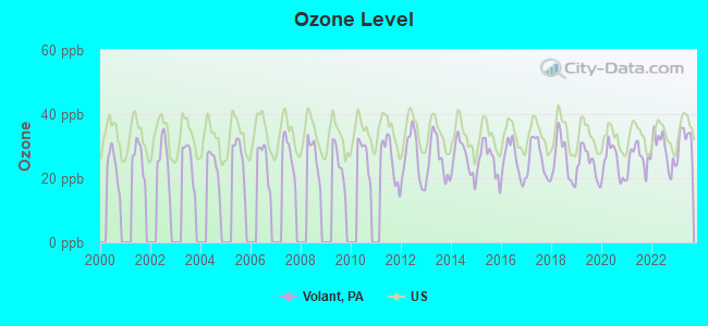
Ozone [ppb] level in 2023 was 32.2. This is about average. Closest monitor was 9.4 miles away from the city center.
| City: | 32.2 |
| U.S.: | 33.3 |
Particulate Matter (PM10) [µg/m3] level in 2023 was 23.4. This is worse than average. Closest monitor was 9.4 miles away from the city center.
| City: | 23.4 |
| U.S.: | 19.2 |

Particulate Matter (PM2.5) [µg/m3] level in 2023 was 10.3. This is worse than average. Closest monitor was 13.6 miles away from the city center.
| City: | 10.3 |
| U.S.: | 8.1 |

Lead (Pb) [µg/m3] level in 2015 was 0.00133. This is significantly better than average. Closest monitor was 9.4 miles away from the city center.
| City: | 0.00133 |
| U.S.: | 0.00931 |
Tornado activity:
Volant-area historical tornado activity is slightly above Pennsylvania state average. It is 2% greater than the overall U.S. average.
On 5/31/1985, a category F5 (max. wind speeds 261-318 mph) tornado 7.3 miles away from the Volant borough center killed 18 people and injured 310 people and caused between $50,000,000 and $500,000,000 in damages.
On 5/31/1985, a category F4 (max. wind speeds 207-260 mph) tornado 28.7 miles away from the borough center killed 16 people and injured 125 people and caused between $5,000,000 and $50,000,000 in damages.
Earthquake activity:
Volant-area historical earthquake activity is significantly above Pennsylvania state average. It is 57% smaller than the overall U.S. average.On 9/25/1998 at 19:52:52, a magnitude 5.2 (4.8 MB, 4.3 MS, 5.2 LG, 4.5 MW, Depth: 3.1 mi, Class: Moderate, Intensity: VI - VII) earthquake occurred 27.0 miles away from Volant center
On 1/31/1986 at 16:46:43, a magnitude 5.0 (5.0 MB) earthquake occurred 57.6 miles away from Volant center
On 8/23/2011 at 17:51:04, a magnitude 5.8 (5.8 MW, Depth: 3.7 mi) earthquake occurred 254.0 miles away from Volant center
On 12/31/2011 at 20:05:01, a magnitude 4.0 (4.0 ML, Depth: 3.1 mi, Class: Light, Intensity: IV - V) earthquake occurred 22.1 miles away from Volant center
On 7/27/1980 at 18:52:21, a magnitude 5.2 (5.1 MB, 4.7 MS, 5.0 UK, 5.2 UK) earthquake occurred 281.0 miles away from the city center
On 6/10/2019 at 14:50:45, a magnitude 4.0 (4.0 MB, Depth: 1.2 mi) earthquake occurred 73.4 miles away from the city center
Magnitude types: regional Lg-wave magnitude (LG), body-wave magnitude (MB), local magnitude (ML), surface-wave magnitude (MS), moment magnitude (MW)
Natural disasters:
The number of natural disasters in Lawrence County (11) is smaller than the US average (15).Major Disasters (Presidential) Declared: 7
Emergencies Declared: 4
Causes of natural disasters: Floods: 4, Storms: 3, Hurricanes: 2, Tornadoes: 2, Tropical Depressions: 2, Snowfall: 1, Snowstorm: 1, Tropical Storm: 1, Winter Storm: 1, Other: 1 (Note: some incidents may be assigned to more than one category).
Hospitals and medical centers near Volant:
- SHENANGO PRESBYTERIAN SENIORCARE (Nursing Home, about 4 miles away; NEW WILMINGTON, PA)
- OVERLOOK HEALTH AND REHABILITATION CENTER (Nursing Home, about 4 miles away; NEW WILMINGTON, PA)
- ALLEGHENY VALLEY SCHOOL (Hospital, about 7 miles away; GROVE CITY, PA)
- JAMESON CARE CENTER (Nursing Home, about 7 miles away; NEW CASTLE, PA)
- COUNTRYSIDE CONV HME LMTD PARTNERSHIP (Nursing Home, about 9 miles away; MERCER, PA)
- COUNTRYSIDE CONVAL HOME LTD PA (Nursing Home, about 9 miles away; MERCER, PA)
- JAMESON MEMORIAL HOSPITAL Acute Care Hospitals (about 9 miles away; NEW CASTLE, PA)
Airports located in Volant:
- Barnes Farmland Airport (PS43) (Runways: 1)
Colleges/universities with over 2000 students nearest to Volant:
- Grove City College (about 10 miles; Grove City, PA; Full-time enrollment: 2,560)
- Slippery Rock University of Pennsylvania (about 12 miles; Slippery Rock, PA; FT enrollment: 8,424)
- Youngstown State University (about 21 miles; Youngstown, OH; FT enrollment: 11,575)
- Butler County Community College (about 27 miles; Butler, PA; FT enrollment: 2,518)
- Allegheny College (about 38 miles; Meadville, PA; FT enrollment: 2,249)
- Robert Morris University (about 42 miles; Moon Township, PA; FT enrollment: 4,823)
- Clarion University of Pennsylvania (about 47 miles; Clarion, PA; FT enrollment: 5,771)
Private elementary/middle schools in Volant:
Points of interest:
Notable location: Volant Volunteer Fire Company (A). Display/hide its location on the map
Hotel: Candleford Inn (Mercer Street).
Birthplace of: William Cunningham (American football) - Football player.
Drinking water stations with addresses in Volant and their reported violations in the past:
GREEN MEADOWS GOLF COURSE (Population served: 60, Groundwater):Past health violations:STANLEY SNYDER VFW (Population served: 50, Groundwater):Past monitoring violations:
- MCL, Monthly (TCR) - Between OCT-2013 and DEC-2013, Contaminant: Coliform. Follow-up actions: St Public Notif requested (NOV-21-2013), St Formal NOV issued (NOV-21-2013), St Compliance achieved (NOV-21-2013), St Public Notif received (DEC-09-2013)
- Monitoring, Source Water (GWR) - Between NOV-25-2013 and DEC-25-2013, Contaminant: E. COLI. Follow-up actions: St Public Notif requested (DEC-27-2013), St Violation/Reminder Notice (DEC-27-2013), St Compliance achieved (DEC-27-2013), St Public Notif received (APR-29-2014)
- One routine major monitoring violation
Past health violations:MARIAS COUNTRY STORE (Population served: 25, Groundwater):
- MCL, Monthly (TCR) - Between OCT-2007 and DEC-2007, Contaminant: Coliform. Follow-up actions: St Public Notif requested (FEB-21-2008), St Public Notif received (FEB-21-2008), St Compliance achieved (FEB-21-2008), St Violation/Reminder Notice (FEB-21-2008)
- MCL, Acute (TCR) - Between OCT-2007 and DEC-2007, Contaminant: Coliform. Follow-up actions: St Public Notif requested (FEB-21-2008), St Public Notif received (FEB-21-2008), St Compliance achieved (FEB-21-2008), St Violation/Reminder Notice (FEB-21-2008)
Past health violations:Past monitoring violations:
- MCL, Monthly (TCR) - In OCT-2013, Contaminant: Coliform. Follow-up actions: St Public Notif requested (NOV-21-2013), St Public Notif received (NOV-21-2013), St Compliance achieved (NOV-21-2013), St Formal NOV issued (NOV-21-2013)
- MCL, Monthly (TCR) - Between JUL-2013 and SEP-2013, Contaminant: Coliform. Follow-up actions: St Public Notif requested (OCT-31-2013), St Compliance achieved (OCT-31-2013), St Formal NOV issued (OCT-31-2013)
- MCL, Monthly (TCR) - In OCT-2011, Contaminant: Coliform. Follow-up actions: St Public Notif requested (DEC-12-2011), St Compliance achieved (DEC-12-2011), St Violation/Reminder Notice (DEC-12-2011)
- Monitoring, Source Water (GWR) - Between NOV-01-2011 and DEC-01-2011, Contaminant: E. COLI. Follow-up actions: St Public Notif requested (DEC-12-2011), St Compliance achieved (DEC-12-2011), St Violation/Reminder Notice (DEC-12-2011)
- Monitoring, Source Water (GWR) - Between OCT-19-2011 and NOV-19-2011, Contaminant: E. COLI. Follow-up actions: St Public Notif requested (DEC-12-2011), St Compliance achieved (DEC-12-2011), St Violation/Reminder Notice (DEC-12-2011)
- Monitoring, Repeat Major (TCR) - In OCT-2011, Contaminant: Coliform (TCR). Follow-up actions: St Public Notif requested (DEC-12-2011), St Compliance achieved (DEC-12-2011), St Violation/Reminder Notice (DEC-12-2011)
- Monitoring, Repeat Major (TCR) - Between JUL-2007 and SEP-2007, Contaminant: Coliform (TCR). Follow-up actions: St Violation/Reminder Notice (OCT-29-2007), St Compliance achieved (OCT-29-2007)
- 2 regular monitoring violations
| This borough: | 2.5 people |
| Pennsylvania: | 2.5 people |
| This borough: | 74.6% |
| Whole state: | 65.0% |
| This borough: | 6.0% |
| Whole state: | 6.6% |
No gay or lesbian households reported
Banks with branches in Volant (2011 data):
- Northwest Savings Bank: Volant Branch at Main Street, branch established on 1955/05/31. Info updated 2009/11/23: Bank assets: $7,975.9 mil, Deposits: $5,985.6 mil, headquarters in Warren, PA, positive income, Mortgage Lending Specialization, 172 total offices
For population 15 years and over in Volant:

- Never married: 18.6%
- Now married: 45.4%
- Separated: 0.6%
- Widowed: 10.6%
- Divorced: 24.7%
For population 25 years and over in Volant:
- High school or higher: 95.7%
- Bachelor's degree or higher: 33.3%
- Graduate or professional degree: 21.7%
- Unemployed: 3.4%
- Mean travel time to work (commute): 15.7 minutes


| Here: | 9.8 |
| Pennsylvania average: | 11.4 |

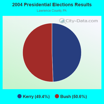
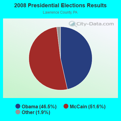
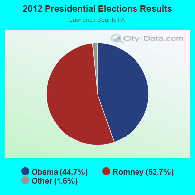


Graphs represent county-level data. Detailed 2008 Election Results
Religion statistics for Volant, PA (based on Lawrence County data)
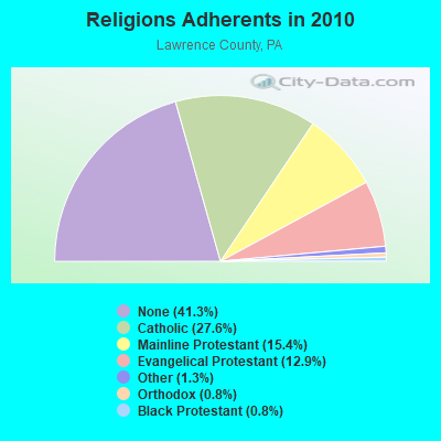
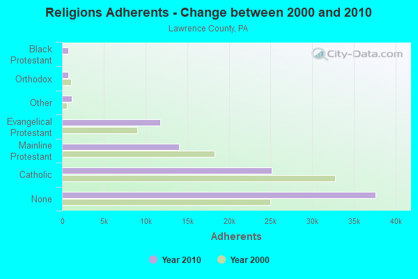
| Religion | Adherents | Congregations |
|---|---|---|
| Catholic | 25,113 | 11 |
| Mainline Protestant | 13,990 | 59 |
| Evangelical Protestant | 11,739 | 76 |
| Other | 1,154 | 4 |
| Orthodox | 761 | 7 |
| Black Protestant | 738 | 7 |
| None | 37,613 | - |
Food Environment Statistics:
| Lawrence County: | 1.65 / 10,000 pop. |
| Pennsylvania: | 2.04 / 10,000 pop. |
| Lawrence County: | 0.11 / 10,000 pop. |
| State: | 0.09 / 10,000 pop. |
| Lawrence County: | 0.99 / 10,000 pop. |
| Pennsylvania: | 0.88 / 10,000 pop. |
| Lawrence County: | 2.98 / 10,000 pop. |
| Pennsylvania: | 2.52 / 10,000 pop. |
| Lawrence County: | 6.50 / 10,000 pop. |
| Pennsylvania: | 7.12 / 10,000 pop. |
| Lawrence County: | 9.9% |
| State: | 9.1% |
| Lawrence County: | 28.1% |
| Pennsylvania: | 27.2% |
| This county: | 14.9% |
| State: | 11.5% |
| Local government employment and payroll (March 2022) | |||||
| Function | Full-time employees | Monthly full-time payroll | Average yearly full-time wage | Part-time employees | Monthly part-time payroll |
|---|---|---|---|---|---|
| Financial Administration | 0 | $0 | 1 | $1,097 | |
| Sewerage | 0 | $0 | 1 | $691 | |
| Water Supply | 0 | $0 | 1 | $761 | |
| Totals for Government | 0 | $0 | 3 | $2,549 | |
Volant government finances - Expenditure in 2017 (per resident):
- Current Operations - Water Utilities: $31,000 ($248.00)
Sewerage: $30,000 ($240.00)
Regular Highways: $21,000 ($168.00)
Central Staff Services: $12,000 ($96.00)
Local Fire Protection: $9,000 ($72.00)
Financial Administration: $8,000 ($64.00)
Solid Waste Management: $8,000 ($64.00)
General - Other: $5,000 ($40.00)
General Public Buildings: $4,000 ($32.00)
Parks and Recreation: $3,000 ($24.00)
Judicial and Legal Services: $1,000 ($8.00)
- General - Interest on Debt: $24,000 ($192.00)
- Other Capital Outlay - Water Utilities: $76,000 ($608.00)
- Total Salaries and Wages: $23,000 ($184.00)
Volant government finances - Revenue in 2017 (per resident):
- Charges - Sewerage: $66,000 ($528.00)
Solid Waste Management: $5,000 ($40.00)
- Miscellaneous - General Revenue - Other: $3,000 ($24.00)
- Revenue - Water Utilities: $31,000 ($248.00)
- State Intergovernmental - Other: $94,000 ($752.00)
Highways: $3,000 ($24.00)
- Tax - Property: $33,000 ($264.00)
Individual Income: $12,000 ($96.00)
Public Utility License: $1,000 ($8.00)
Occupation and Business License - Other: $1,000 ($8.00)
Documentary and Stock Transfer: $1,000 ($8.00)
Volant government finances - Debt in 2017 (per resident):
- Long Term Debt - Beginning Outstanding - Unspecified Public Purpose: $599,000 ($4792.00)
Outstanding Unspecified Public Purpose: $572,000 ($4576.00)
Retired Unspecified Public Purpose: $27,000 ($216.00)
Volant government finances - Cash and Securities in 2017 (per resident):
- Other Funds - Cash and Securities: $84,000 ($672.00)
- Sinking Funds - Cash and Securities: $82,000 ($656.00)
Strongest AM radio stations in Volant:
- WBZY (1280 AM; 5 kW; NEW CASTLE, PA; Owner: CITICASTERS LICENSES, L.P.)
- KDKA (1020 AM; 50 kW; PITTSBURGH, PA; Owner: INFINITY BROADCASTING OPERATIONS, INC.)
- WKST (1200 AM; 5 kW; NEW CASTLE, PA; Owner: CITICASTERS LICENSES, L.P.)
- WKBN (570 AM; 5 kW; YOUNGSTOWN, OH; Owner: CITICASTERS LICENSES, L.P.)
- WNIO (1390 AM; 10 kW; YOUNGSTOWN, OH; Owner: YOUNGSTOWN RADIO LICENSE, L.L.C.)
- WKNR (850 AM; 50 kW; CLEVELAND, OH; Owner: CARON BROADCASTING, INC.)
- WTAM (1100 AM; 50 kW; CLEVELAND, OH; Owner: JACOR BROADCASTING CORPORATION)
- WWVA (1170 AM; 53 kW; WHEELING, WV; Owner: CAPSTAR TX LIMITED PARTNERSHIP)
- WHK (1220 AM; 50 kW; CLEVELAND, OH; Owner: CARON BROADCASTING, INC.)
- WPIC (790 AM; 1 kW; SHARON, PA; Owner: CUMULUS LICENSING CORP.)
- WHKW (1440 AM; 5 kW; WARREN, OH; Owner: SCA LICENSE CORPORATION)
- WSAJ (1340 AM; 0 kW; GROVE CITY, PA; Owner: GROVE CITY COLLEGE)
- WHBC (1480 AM; 15 kW; CANTON, OH; Owner: NM LICENSING, LLC)
Strongest FM radio stations in Volant:
- WICT (95.1 FM; GROVE CITY, PA; Owner: YOUNGSTOWN RADIO LICENSE, L.L.C.)
- W248AD (97.5 FM; NEW WILMINGTON, PA; Owner: YOUNGSTOWN STATE UNIVERSITY)
- WMXY (98.9 FM; YOUNGSTOWN, OH; Owner: CITICASTERS LICENSES, L.P.)
- WVMN (90.1 FM; NEW CASTLE, PA; Owner: THE MOODY BIBLE INSTITUTE OF CHICAGO)
- WLLF (96.7 FM; MERCER, PA; Owner: CUMULUS LICENSING CORP.)
- WWIZ (103.9 FM; MERCER, PA; Owner: CUMULUS LICENSING CORP.)
- WHOT-FM (101.1 FM; YOUNGSTOWN, OH; Owner: CUMULUS LICENSING CORP.)
- WWNW (88.9 FM; NEW WILMINGTON, PA; Owner: WESTMINSTER COLLEGE BD. OF TRUSTEES)
- WSAJ-FM (91.1 FM; GROVE CITY, PA; Owner: GROVE CITY COLLEGE)
- WRBP (101.9 FM; HUBBARD, OH; Owner: STOP 26-RIVERBEND, INC.)
- WYFM (102.9 FM; SHARON, PA; Owner: CUMULUS LICENSING CORP.)
- WYTN (91.7 FM; YOUNGSTOWN, OH; Owner: FAMILY STATIONS, INC.)
- WQXK (105.1 FM; SALEM, OH; Owner: CUMULUS LICENSING CORP.)
- WAKZ (95.9 FM; SHARPSVILLE, PA; Owner: YOUNGSTOWN RADIO LICENSE, L.L.C.)
- WAMO-FM (106.7 FM; BEAVER FALLS, PA; Owner: MCL/MCM-INC)
- WJST (92.1 FM; ELLWOOD CITY, PA; Owner: CITICASTERS LICENSES, L.P.)
- WZPT (100.7 FM; NEW KENSINGTON, PA; Owner: INFINITY RADIO SUBSIDIARY OPERATIONS INC.)
- WOXX (99.3 FM; FRANKLIN, PA; Owner: FOREVER BROADCASTING, LLC)
- WYSU (88.5 FM; YOUNGSTOWN, OH; Owner: YOUNGSTOWN STATE UNIVERSITY)
- WOGF (104.3 FM; EAST LIVERPOOL, OH; Owner: KEYMARKET LICENSES, LLC)
TV broadcast stations around Volant:
- WFXI-CA (Channel 17; MERCER, PA; Owner: PIEDMONT TELEVISION OF YOUNGSTOWN LICENSE LLC)
- WKBN-TV (Channel 27; YOUNGSTOWN, OH; Owner: PIEDMONT TELEVISION OF YOUNGSTOWN LICENSE LLC)
- W56CL (Channel 56; NEW CASTLE, PA; Owner: BRUNO-GOODWORTH NETWORK, INC.)
- WFMJ-TV (Channel 21; YOUNGSTOWN, OH; Owner: WFMJ TELEVISION, INC.)
- WYFX-LP (Channel 62; YOUNGSTOWN, OH; Owner: PIEDMONT TELEVISION OF YOUNGSTOWN LICENSE LLC)
- WYTV (Channel 33; YOUNGSTOWN, OH; Owner: CHELSEY BROADCASTING COMPANY OF YOUNGSTOWN, LLC)
- W50BF (Channel 50; SHARON, PA; Owner: CORNERSTONE TELEVISION, INC.)
- W66BQ (Channel 66; BEAVER, PA; Owner: BRUNO-GOODWORTH NETWORK, INC.)
- WNEO (Channel 45; ALLIANCE, OH; Owner: NORTHEASTERN EDUCATIONAL TELEVISION OF OHIO, INC.)
- W52DS (Channel 52; YOUNGSTOWN, OH; Owner: TRINITY BROADCASTING NETWORK)
- National Bridge Inventory (NBI) Statistics
- 25Number of bridges
- 184ft / 55.5mTotal length
- $1,909,000Total costs
- 49,357Total average daily traffic
- 3,897Total average daily truck traffic
- 61,363Total future (year 2020) average daily traffic

- New bridges - historical statistics
- 1Before 1900
- 11900-1909
- 21910-1919
- 31920-1929
- 11930-1939
- 31960-1969
- 11970-1979
- 21980-1989
- 11990-1999
- 82010-2019
- 22020-2022
FCC Registered Cell Phone Towers:
2 (See the full list of FCC Registered Cell Phone Towers in Volant)FCC Registered Antenna Towers:
43 (See the full list of FCC Registered Antenna Towers)FCC Registered Broadcast Land Mobile Towers:
1- Lat: 41.190056 Lon: -80.450611, Call Sign: WPUX960,
Assigned Frequencies: 467.462 MHz, 467.812 MHz, 467.837 MHz, 467.862 MHz, Grant Date: 05/23/2002, Expiration Date: 05/23/2012, Cancellation Date: 07/28/2012, Certifier: Jeff Iwanekjo, Registrant: Cara Enterprises Inc, Salt Lake City, UT 84117-0503, Phone: (801) 278-9728, Fax: (801) 278-7239
FCC Registered Amateur Radio Licenses:
17 (See the full list of FCC Registered Amateur Radio Licenses in Volant)FAA Registered Aircraft:
3- Aircraft: PIPER PA-12 (Category: Land, Seats: 3, Weight: Up to 12,499 Pounds, Speed: 82 mph), Engine: LYCOMING 0-235 SERIES (115 HP) (Reciprocating)
N-Number: 4485M, N4485M, N-4485M, Serial Number: 12-3438, Year manufactured: 1947, Airworthiness Date: 08/27/1955, Certificate Issue Date: 01/28/2009
Registrant (Individual): Donald W Barnes, 300 Vosler Rd, Volant, PA 16156 - Aircraft: QUADRONE PRO CAM (Category: Land), Engine: Electric
N-Number: 786VP, N786VP, N-786VP, Serial Number: OLV13809675763, Certificate Issue Date: 08/30/2016
Registrant (Individual): Wayne D Palmer, 5096 State Route 208, Volant, PA 16156
Deregistered: Cancel Date: 12/02/2019 - Aircraft: WINDER ROBERT S VPI (Category: Land, Weight: Up to 12,499 Pounds), Engine: AMA/EXPR UNKNOWN ENG (4 Cycle)
N-Number: 3831W, N3831W, N-3831W, Serial Number: 01, Year manufactured: 2010, Airworthiness Date: 12/08/2010, Certificate Issue Date: 06/12/2009
Registrant (Individual): Robert S Winder, 2597 Leesburg Grove City Rd, Volant, PA 16156
Deregistered: Cancel Date: 01/04/2018

- 97.0%Utility gas
- 3.0%Electricity

- 75.0%Utility gas
- 12.5%Electricity
- 12.5%Fuel oil, kerosene, etc.
Volant compared to Pennsylvania state average:
- Median house value below state average.
- Unemployed percentage significantly below state average.
- Black race population percentage significantly below state average.
- Hispanic race population percentage significantly below state average.
- Foreign-born population percentage below state average.
- Length of stay since moving in significantly above state average.
- House age above state average.

|
Total of 3 patent applications in 2008-2024.