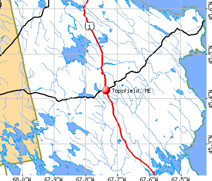
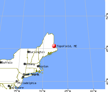
Topsfield, Maine
Submit your own pictures of this town and show them to the world
- OSM Map
- General Map
- Google Map
- MSN Map
Population change since 2000: +5.3%
 |
| Males: 127 | |
| Females: 110 |
| Median resident age: | 49.3 years |
| Maine median age: | 43.0 years |
Zip codes: 04490.
| Topsfield: | $53,422 |
| ME: | $69,543 |
Estimated per capita income in 2022: $32,629 (it was $14,456 in 2000)
Topsfield town income, earnings, and wages data
Estimated median house or condo value in 2022: $116,786 (it was $48,100 in 2000)
| Topsfield: | $116,786 |
| ME: | $290,600 |
Mean prices in 2022: all housing units: $208,896; detached houses: $229,377; townhouses or other attached units: $190,242; in 2-unit structures: $139,050; in 3-to-4-unit structures: $456,045; in 5-or-more-unit structures: $413,457; mobile homes: $94,515; occupied boats, rvs, vans, etc.: $45,679
Detailed information about poverty and poor residents in Topsfield, ME


- 23599.2%White alone
- 10.4%American Indian alone
- 10.4%Other race alone

Races in Topsfield detailed stats: ancestries, foreign born residents, place of birth
 Recent articles from our blog. Our writers, many of them Ph.D. graduates or candidates, create easy-to-read articles on a wide variety of topics.

 | Thinking about rural Maine. (27 replies) |
| Daily Snow Depth Map (14 replies) |
| Planning my move to Maine (52 replies) |
| Best residential areas near Portland? (4 replies) |
| Maine Wreaths (18 replies) |
| Maine weather thread (3207 replies) |
Latest news from Topsfield, ME collected exclusively by city-data.com from local newspapers, TV, and radio stations
Ancestries: English (53.3%), Irish (13.3%), French (12.4%), Scottish (11.1%), United States (8.9%), Scotch-Irish (8.4%).
Current Local Time: EST time zone
Incorporated on 02/24/1838
Elevation: 488 feet
Land area: 50.7 square miles.
Population density: 4.7 people per square mile (very low).
3 residents are foreign born
| This town: | 1.3% |
| Maine: | 2.9% |
| Topsfield town: | 1.5% ($725) |
| Maine: | 1.5% ($1,417) |
Nearest city with pop. 50,000+: Portland, ME  (173.6 miles , pop. 64,249).
Nearest city with pop. 200,000+: Boston, MA (271.4 miles , pop. 589,141).
Nearest city with pop. 1,000,000+: Bronx, NY (441.9 miles , pop. 1,332,650).
Nearest cities:
), ), Latitude: 45.43 N, Longitude: 67.76 W
Area code commonly used in this area: 207


| Here: | 2.3% |
| Maine: | 3.4% |


- Agriculture, forestry, fishing & hunting (22.5%)
- Educational services (16.7%)
- Health care (8.8%)
- Paper (7.8%)
- Apparel (6.9%)
- Social assistance (5.9%)
- Construction (4.9%)

- Agriculture, forestry, fishing & hunting (38.3%)
- Educational services (15.0%)
- Paper (13.3%)
- Machinery, equipment, supplies merchant wholesalers (5.0%)
- Construction (5.0%)
- Lumber & other construction materials merchant wholesalers (5.0%)
- Truck transportation (5.0%)

- Educational services (19.0%)
- Apparel (16.7%)
- Health care (14.3%)
- Accommodation & food services (11.9%)
- Food & beverage stores (7.1%)
- Social assistance (7.1%)
- Department & other general merchandise stores (4.8%)

- Fishing, hunting, and forestry occupations (17.6%)
- Other production occupations, including supervisors (11.8%)
- Counselors, social workers, and other community and social service specialists (5.9%)
- Driver/sales workers and truck drivers (5.9%)
- Preschool, kindergarten, elementary, and middle school teachers (4.9%)
- Waiters and waitresses (4.9%)
- Information and record clerks, except customer service representatives (3.9%)

- Fishing, hunting, and forestry occupations (30.0%)
- Other production occupations, including supervisors (15.0%)
- Counselors, social workers, and other community and social service specialists (10.0%)
- Driver/sales workers and truck drivers (10.0%)
- Building and grounds cleaning and maintenance occupations (5.0%)
- Therapists (5.0%)
- Life, physical, and social science technicians (5.0%)

- Preschool, kindergarten, elementary, and middle school teachers (11.9%)
- Waiters and waitresses (11.9%)
- Information and record clerks, except customer service representatives (9.5%)
- Nursing, psychiatric, and home health aides (9.5%)
- Textile, apparel, and furnishings workers (9.5%)
- Cooks and food preparation workers (7.1%)
- Other teachers, instructors, education, training, and library occupations (7.1%)
Average climate in Topsfield, Maine
Based on data reported by over 4,000 weather stations


Earthquake activity:
Topsfield-area historical earthquake activity is significantly above Maine state average. It is 84% smaller than the overall U.S. average.On 4/20/2002 at 10:50:47, a magnitude 5.3 (5.3 ML, Depth: 3.0 mi, Class: Moderate, Intensity: VI - VII) earthquake occurred 297.3 miles away from Topsfield center
On 10/16/2012 at 23:12:25, a magnitude 4.7 (4.7 ML, Depth: 10.0 mi, Class: Light, Intensity: IV - V) earthquake occurred 190.8 miles away from Topsfield center
On 4/20/2002 at 10:50:47, a magnitude 5.2 (5.2 MB, 4.2 MS, 5.2 MW, 5.0 MW) earthquake occurred 298.7 miles away from Topsfield center
On 10/7/1983 at 10:18:46, a magnitude 5.3 (5.1 MB, 5.3 LG, 5.1 ML) earthquake occurred 339.2 miles away from Topsfield center
On 1/19/1982 at 00:14:42, a magnitude 4.7 (4.5 MB, 4.7 MD, 4.5 LG) earthquake occurred 231.7 miles away from the city center
On 9/16/1994 at 07:01:54, a magnitude 3.6 (3.5 LG, 3.6 LG, Depth: 3.1 mi, Class: Light, Intensity: II - III) earthquake occurred 23.1 miles away from Topsfield center
Magnitude types: regional Lg-wave magnitude (LG), body-wave magnitude (MB), duration magnitude (MD), local magnitude (ML), surface-wave magnitude (MS), moment magnitude (MW)
Natural disasters:
The number of natural disasters in Washington County (20) is greater than the US average (15).Major Disasters (Presidential) Declared: 14
Emergencies Declared: 6
Causes of natural disasters: Floods: 11, Storms: 10, Snows: 5, Winds: 2, Winter Storms: 2, Blizzard: 1, Heavy Rain: 1, Hurricane: 1, Ice Storm: 1, Landslide: 1, Snowfall: 1, Other: 2 (Note: some incidents may be assigned to more than one category).

Colleges/universities with over 2000 students nearest to Topsfield:
- University of Maine (about 58 miles; Orono, ME; Full-time enrollment: 8,931)
- Husson University (about 66 miles; Bangor, ME; FT enrollment: 2,421)
- University of Maine at Augusta (about 126 miles; Augusta, ME; FT enrollment: 3,204)
- University of Maine at Farmington (about 128 miles; Farmington, ME; FT enrollment: 2,036)
- Southern Maine Community College (about 174 miles; South Portland, ME; FT enrollment: 4,666)
- Saint Joseph's College of Maine (about 174 miles; Standish, ME; FT enrollment: 2,010)
- University of Southern Maine (about 174 miles; Portland, ME; FT enrollment: 6,647)
Public elementary/middle school in Topsfield:
- EAST RANGE II CSD SCHOOL (Students: 39, Location: 187 SCHOOL STREET, Grades: KG-8)
Points of interest:
Notable location: Topsfield Volunteer Fire Department (A). Display/hide its location on the map
Lakes and swamps: East Musquash Lake (A), Farrow Lake (B), Pickerel Pond (C), Malcome Bog (D), Lathrop Heath (E), Deadman Bog (F). Display/hide their locations on the map
Streams, rivers, and creeks: Stuart Brook (A), Woodcock Brook (B), Doren Brook (C), Flood Brook (D), Sweet Brook (E), Burbee Brook (F), Brooks and Walden Brook (G), Baskahegan Stream (H). Display/hide their locations on the map
Drinking water stations with addresses in Topsfield and their reported violations in the past:
MAINE WILDERNESS CAMPS (Population served: 97, Groundwater):Past health violations:Past monitoring violations:
- MCL, Monthly (TCR) - In AUG-2011, Contaminant: Coliform. Follow-up actions: St Public Notif requested (SEP-16-2011), St Formal NOV issued (SEP-16-2011), St Public Notif received (OCT-14-2011), St Compliance achieved (JUN-28-2012)
- MCL, Monthly (TCR) - In JUL-2010, Contaminant: Coliform. Follow-up actions: St Public Notif requested (JUL-30-2010), St Formal NOV issued (JUL-30-2010), St Compliance achieved (AUG-30-2010), St Public Notif received (AUG-31-2010)
- MCL, Monthly (TCR) - In JUN-2010, Contaminant: Coliform. Follow-up actions: St Public Notif requested (JUN-29-2010), St Formal NOV issued (JUN-29-2010), St Public Notif received (JUL-09-2010), St Compliance achieved (AUG-30-2010)
- MCL, Monthly (TCR) - Between OCT-2008 and DEC-2008, Contaminant: Coliform. Follow-up actions: St Public Notif requested (NOV-10-2008), St Formal NOV issued (NOV-10-2008), St Public Notif received (DEC-10-2008), St Intentional no-action (SEP-09-2011), St Compliance achieved (SEP-09-2011)
- MCL, Monthly (TCR) - In AUG-2008, Contaminant: Coliform. Follow-up actions: St Public Notif requested (SEP-05-2008), St Formal NOV issued (SEP-05-2008), St Public Notif received (SEP-24-2008), St Compliance achieved (OCT-15-2008)
- MCL, Monthly (TCR) - In DEC-2006, Contaminant: Coliform. Follow-up actions: St Public Notif requested (JAN-02-2007), St Violation/Reminder Notice (JAN-02-2007), St Public Notif received (JAN-23-2007), St Compliance achieved (SEP-07-2011), St Intentional no-action (SEP-09-2011)
- 4 routine major monitoring violations
| This town: | 2.5 people |
| Maine: | 2.3 people |
| This town: | 77.9% |
| Whole state: | 62.9% |
| This town: | 6.3% |
| Whole state: | 9.4% |
Likely homosexual households (counted as self-reported same-sex unmarried-partner households)
- Lesbian couples: 0.0% of all households
- Gay men: 1.1% of all households
| This town: | 13.5% |
| Whole state: | 10.9% |
| This town: | 3.9% |
| Whole state: | 4.1% |
For population 15 years and over in Topsfield:

- Never married: 20.2%
- Now married: 66.0%
- Separated: 0.0%
- Widowed: 8.0%
- Divorced: 5.9%
For population 25 years and over in Topsfield:
- High school or higher: 74.1%
- Bachelor's degree or higher: 8.4%
- Graduate or professional degree: 6.0%
- Unemployed: 5.6%
- Mean travel time to work (commute): 28.9 minutes


| Here: | 10.2 |
| Maine average: | 11.2 |
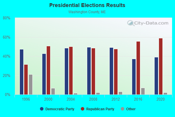

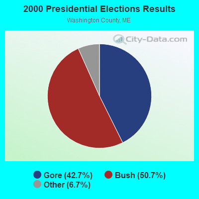


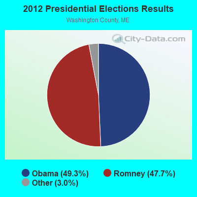


Graphs represent county-level data. Detailed 2008 Election Results
Religion statistics for Topsfield, ME (based on Washington County data)
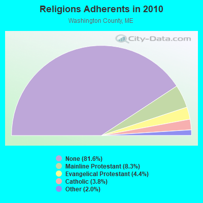
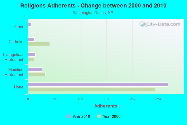
| Religion | Adherents | Congregations |
|---|---|---|
| Mainline Protestant | 2,731 | 37 |
| Evangelical Protestant | 1,442 | 31 |
| Catholic | 1,238 | 10 |
| Other | 648 | 13 |
| None | 26,797 | - |
Food Environment Statistics:
| This county: | 4.89 / 10,000 pop. |
| Maine: | 2.80 / 10,000 pop. |
| Here: | 1.22 / 10,000 pop. |
| State: | 2.20 / 10,000 pop. |
| Washington County: | 9.78 / 10,000 pop. |
| Maine: | 5.75 / 10,000 pop. |
| Here: | 11.31 / 10,000 pop. |
| State: | 11.02 / 10,000 pop. |
| Here: | 9.4% |
| Maine: | 8.2% |
| Washington County: | 28.3% |
| Maine: | 25.0% |
Strongest AM radio stations in Topsfield:
- WZON (620 AM; 5 kW; BANGOR, ME; Owner: THE ZONE CORPORATION)
- WREM (710 AM; daytime; 5 kW; MONTICELLO, ME; Owner: ALLAN H WEINER)
- WABI (910 AM; 5 kW; BANGOR, ME; Owner: CLEAR CHANNEL BROADCASTING LICENSES, INC.)
- WRKO (680 AM; 50 kW; BOSTON, MA; Owner: ENTERCOM BOSTON LICENSE, LLC)
- WSKW (1160 AM; 10 kW; SKOWHEGAN, ME; Owner: MOUNTAIN WIRELESS, INCORPORATED)
- WFST (600 AM; 5 kW; CARIBOU, ME; Owner: NORTHERN BROADCAST MINISTRIES, INC.)
- WEEI (850 AM; 50 kW; BOSTON, MA; Owner: ENTERCOM BOSTON LICENSE, LLC)
- WBZ (1030 AM; 50 kW; BOSTON, MA; Owner: INFINITY BROADCASTING OPERATIONS, INC.)
- WDEA (1370 AM; 5 kW; ELLSWORTH, ME; Owner: CUMULUS LICENSING CORP.)
- WNNZ (640 AM; 50 kW; WESTFIELD, MA; Owner: CLEAR CHANNEL BROADCASTING LICENSES, INC.)
- WCRN (830 AM; 50 kW; WORCESTER, MA; Owner: CARTER BROADCASTING CORPORATION)
- WCHP (760 AM; 35 kW; CHAMPLAIN, NY; Owner: CHAMPLAIN RADIO, INC.)
- WTME (780 AM; 10 kW; RUMFORD, ME; Owner: MOUNTAIN VALLEY BROADCASTING, INC.)
Strongest FM radio stations in Topsfield:
- WHCF (88.5 FM; BANGOR, ME; Owner: BANGOR BAPTIST CHURCH)
- WVOM (103.9 FM; HOWLAND, ME; Owner: CLEAR CHANNEL BROADCASTING LICENSES, INC.)
- Topsfield, Maine
- Fatal accident count10
- Vehicles involved in fatal accidents13
- Fatal accidents involving drunk persons:4
- Fatalities10
- Persons involved in fatal accidents17
- Pedestrians involved in fatal accidents1
- Maine average
- Fatal accident count1258
- Vehicles involved in fatal accidents1827
- Fatal accidents involving drunk persons442
- Fatalities1399
- Persons involved in fatal accidents2910
- Pedestrians involved in fatal accidents131
FCC Registered Cell Phone Towers:
1 (See the full list of FCC Registered Cell Phone Towers in Topsfield)FCC Registered Antenna Towers:
17 (See the full list of FCC Registered Antenna Towers)FCC Registered Broadcast Land Mobile Towers:
9 (See the full list of FCC Registered Broadcast Land Mobile Towers in Topsfield, ME)FCC Registered Microwave Towers:
3- TOPSFIELD, 3.7 Mi Bearing 235 From (Lat: 45.388333 Lon: -67.797778), Type: Gtower, Structure height: 91.4 m, Overall height: 99.1 m, Call Sign: WPJD834,
Assigned Frequencies: 6004.50 MHz, Grant Date: 01/12/2021, Expiration Date: 02/01/2031, Certifier: John E Rooney, Registrant: Wilkinson Barker Knauer, LLP, 1800 M Street Nw, Suite 800n, Washington, DC 20036, Phone: (202) 383-3420, Fax: (202) 783-5851, Email:
- Musquash Mtn (Lat: 45.389222 Lon: -67.796667), Overall height: 42.7 m, Call Sign: WPNA610,
Assigned Frequencies: 6605.00 MHz, Grant Date: 12/21/2021, Expiration Date: 02/26/2032, Registrant: State Of Maine, O.I.T., Radio Operations, 66 Industrial Drive, Augusta, ME 04333-0147, Phone: (207) 624-9990, Email:
- MUSQUASH MTN, Musquash Mountain (Lat: 45.389250 Lon: -67.796667), Type: Mast, Structure height: 54.9 m, Call Sign: WQNM923,
Assigned Frequencies: 942.575 MHz, 942.175 MHz, 6585.00 MHz, 6625.00 MHz, 6585.00 MHz, 6625.00 MHz, 6585.00 MHz, 6625.00 MHz, 6585.00 MHz, 6625.00 MHz... (+8 more), Grant Date: 01/29/2021, Expiration Date: 03/28/2031, Certifier: David E Mars, Registrant: State Of Maine, O.I.T., Radio Operations, 66 Industrial Drive, Augusta, ME 04333-0147, Phone: (207) 624-9990, Email:
FCC Registered Amateur Radio Licenses:
2- Call Sign: KC1QE, Licensee ID: L01462023, Grant Date: 03/03/2021, Expiration Date: 03/03/2031, Certifier: Gustave A Zeissig, Registrant: Gustave A Zeissig, 139 School Road, Topsfield, ME 04490
- Call Sign: KC1TVT, Licensee ID: L02732718, Grant Date: 12/12/2023, Expiration Date: 12/12/2033, Certifier: Steven M Rhoades, Registrant: Steven M Rhoades, 348 South Rd, Topsfield, ME 04490-3218
FAA Registered Aircraft:
1- Aircraft: GARABEDIAN JOHN C CUB (Category: Land, Seats: 2, Weight: Up to 12,499 Pounds), Engine: LYCOMING O-235-L2C (118 HP) (Reciprocating)
N-Number: 541PG, N541PG, N-541PG, Serial Number: 1903, Year manufactured: 2015, Airworthiness Date: 06/12/2015, Certificate Issue Date: 07/09/2019
Registrant (Individual): Albert D Tremblay, 603 Lakeview Rd, Topsfield, ME 04490
Topsfield compared to Maine state average:
- Median house value significantly below state average.
- Unemployed percentage below state average.
- Black race population percentage significantly below state average.
- Hispanic race population percentage significantly below state average.
- Median age above state average.
- Foreign-born population percentage significantly below state average.
- Renting percentage significantly below state average.
- Length of stay since moving in significantly above state average.
- Number of rooms per house significantly below state average.
- House age significantly below state average.
- Number of college students significantly below state average.
- Percentage of population with a bachelor's degree or higher significantly below state average.