Tolland, Massachusetts
Submit your own pictures of this town and show them to the world
- OSM Map
- Google Map
- MSN Map
Population change since 2000: +13.8%
 |
| Males: 236 | |
| Females: 249 |
| Median resident age: | 47.7 years |
| Massachusetts median age: | 39.2 years |
Zip codes: 01034.
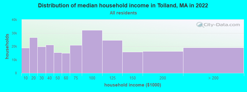
| Tolland: | $85,424 |
| MA: | $94,488 |
Estimated per capita income in 2022: $52,864 (it was $30,126 in 2000)
Tolland town income, earnings, and wages data
Estimated median house or condo value in 2022: $416,575 (it was $167,900 in 2000)
| Tolland: | $416,575 |
| MA: | $534,700 |
Mean prices in 2022: all housing units: $315,253; detached houses: $334,901; townhouses or other attached units: $238,289; in 2-unit structures: $223,248; in 3-to-4-unit structures: $195,645; in 5-or-more-unit structures: $166,405; mobile homes: $156,908
Detailed information about poverty and poor residents in Tolland, MA


- 45994.6%White alone
- 81.6%Two or more races
- 61.2%Black alone
- 61.2%Hispanic
- 51.0%American Indian alone
- 10.2%Asian alone

Races in Tolland detailed stats: ancestries, foreign born residents, place of birth
According to our research of Massachusetts and other state lists, there was 1 registered sex offender living in Tolland, Massachusetts as of May 29, 2024.
The ratio of all residents to sex offenders in Tolland is 485 to 1.
 Recent articles from our blog. Our writers, many of them Ph.D. graduates or candidates, create easy-to-read articles on a wide variety of topics.
Ancestries: English (27.0%), Irish (16.9%), Italian (12.7%), French (11.3%), Polish (9.6%), German (7.7%).
Current Local Time: EST time zone
Incorporated in 1810
Land area: 31.6 square miles.
Population density: 15 people per square mile (very low).
3 residents are foreign born
| This town: | 0.7% |
| Massachusetts: | 12.2% |
| Tolland town: | 0.5% ($806) |
| Massachusetts: | 1.3% ($2,336) |
Nearest city with pop. 50,000+: Chicopee, MA  (23.7 miles , pop. 54,653).
Nearest city with pop. 200,000+: Bronx, NY (95.4 miles , pop. 1,332,650).
Nearest cities:
), ), ), ), ), Latitude: 42.07 N, Longitude: 73.03 W
Area code commonly used in this area: 413
Single-family new house construction building permits:
- 2022: 4 buildings, average cost: $259,200
- 2021: 3 buildings, average cost: $259,200
- 2019: 1 building, cost: $217,000
- 2018: 3 buildings, average cost: $355,900
- 2017: 5 buildings, average cost: $80,000
- 2016: 6 buildings, average cost: $220,400
- 2015: 2 buildings, average cost: $231,500
- 2014: 2 buildings, average cost: $231,000
- 2010: 1 building, cost: $357,000
- 2009: 1 building, cost: $400,000
- 2008: 4 buildings, average cost: $241,100
- 2007: 4 buildings, average cost: $191,200
- 2006: 8 buildings, average cost: $368,200
- 2005: 8 buildings, average cost: $134,200
- 2004: 6 buildings, average cost: $235,500
- 2003: 10 buildings, average cost: $250,600
- 2002: 6 buildings, average cost: $153,300
- 2001: 2 buildings, average cost: $275,000
- 2000: 2 buildings, average cost: $125,000
- 1999: 6 buildings, average cost: $70,500
- 1998: 2 buildings, average cost: $125,000
- 1997: 1 building, cost: $100,000


| Here: | 2.7% |
| Massachusetts: | 3.5% |


- Educational services (13.6%)
- Construction (9.6%)
- Finance & insurance (7.9%)
- Public administration (5.7%)
- Health care (5.7%)
- Religious, grantmaking, civic, professional, similar organizations (4.4%)
- Miscellaneous manufacturing (4.4%)

- Construction (16.9%)
- Real estate & rental & leasing (6.2%)
- Educational services (6.2%)
- Miscellaneous manufacturing (5.4%)
- Finance & insurance (5.4%)
- Public administration (4.6%)
- Truck transportation (4.6%)

- Educational services (23.5%)
- Finance & insurance (11.2%)
- Health care (8.2%)
- Public administration (7.1%)
- Religious, grantmaking, civic, professional, similar organizations (5.1%)
- Textile mills & textile products (4.1%)
- Furniture & related product manufacturing (3.1%)

- Other management occupations, except farmers and farm managers (7.5%)
- Other sales and related occupations, including supervisors (5.7%)
- Supervisors and other personal care and service workers, except child care workers (4.8%)
- Other teachers, instructors, education, training, and library occupations (4.8%)
- Building and grounds cleaning and maintenance occupations (4.8%)
- Retail sales workers, except cashiers (4.4%)
- Computer specialists (3.5%)

- Other management occupations, except farmers and farm managers (11.5%)
- Supervisors and other personal care and service workers, except child care workers (8.5%)
- Building and grounds cleaning and maintenance occupations (6.9%)
- Retail sales workers, except cashiers (5.4%)
- Other sales and related occupations, including supervisors (5.4%)
- Construction traders workers except carpenters, electricians, painters, plumbers, and construction laborers (5.4%)
- Computer specialists (4.6%)

- Other teachers, instructors, education, training, and library occupations (9.2%)
- Counselors, social workers, and other community and social service specialists (6.1%)
- Accountants and auditors (6.1%)
- Teachers, secondary school (6.1%)
- Other sales and related occupations, including supervisors (6.1%)
- Assemblers and fabricators (6.1%)
- Operations specialties managers, except financial managers (5.1%)
Average climate in Tolland, Massachusetts
Based on data reported by over 4,000 weather stations


(lower is better)

Air Quality Index (AQI) level in 2022 was 69.3. This is about average.
| City: | 69.3 |
| U.S.: | 72.6 |

Carbon Monoxide (CO) [ppm] level in 2022 was 0.149. This is significantly better than average. Closest monitor was 22.2 miles away from the city center.
| City: | 0.149 |
| U.S.: | 0.251 |

Nitrogen Dioxide (NO2) [ppb] level in 2015 was 2.27. This is significantly better than average. Closest monitor was 18.1 miles away from the city center.
| City: | 2.27 |
| U.S.: | 5.11 |

Sulfur Dioxide (SO2) [ppb] level in 2022 was 0.124. This is significantly better than average. Closest monitor was 18.1 miles away from the city center.
| City: | 0.124 |
| U.S.: | 1.515 |

Ozone [ppb] level in 2022 was 37.6. This is about average. Closest monitor was 17.5 miles away from the city center.
| City: | 37.6 |
| U.S.: | 33.3 |

Particulate Matter (PM10) [µg/m3] level in 2022 was 9.49. This is significantly better than average. Closest monitor was 19.3 miles away from the city center.
| City: | 9.49 |
| U.S.: | 19.21 |

Particulate Matter (PM2.5) [µg/m3] level in 2022 was 5.85. This is better than average. Closest monitor was 22.2 miles away from the city center.
| City: | 5.85 |
| U.S.: | 8.11 |
Tornado activity:
Tolland-area historical tornado activity is above Massachusetts state average. It is 12% smaller than the overall U.S. average.
On 5/29/1995, a category F4 (max. wind speeds 207-260 mph) tornado 9.7 miles away from the Tolland town center killed 3 people and injured 24 people and caused between $5,000,000 and $50,000,000 in damages.
On 10/3/1979, a category F4 tornado 17.1 miles away from the town center killed 3 people and injured 500 people and caused between $50,000,000 and $500,000,000 in damages.
Earthquake activity:
Tolland-area historical earthquake activity is significantly above Massachusetts state average. It is 69% smaller than the overall U.S. average.On 10/7/1983 at 10:18:46, a magnitude 5.3 (5.1 MB, 5.3 LG, 5.1 ML, Class: Moderate, Intensity: VI - VII) earthquake occurred 145.9 miles away from the city center
On 4/20/2002 at 10:50:47, a magnitude 5.3 (5.3 ML, Depth: 3.0 mi) earthquake occurred 171.9 miles away from the city center
On 4/20/2002 at 10:50:47, a magnitude 5.2 (5.2 MB, 4.2 MS, 5.2 MW, 5.0 MW) earthquake occurred 170.4 miles away from the city center
On 1/19/1982 at 00:14:42, a magnitude 4.7 (4.5 MB, 4.7 MD, 4.5 LG, Class: Light, Intensity: IV - V) earthquake occurred 122.5 miles away from Tolland center
On 10/16/2012 at 23:12:25, a magnitude 4.7 (4.7 ML, Depth: 10.0 mi) earthquake occurred 160.1 miles away from the city center
On 8/23/2011 at 17:51:04, a magnitude 5.8 (5.8 MW, Depth: 3.7 mi) earthquake occurred 387.8 miles away from Tolland center
Magnitude types: regional Lg-wave magnitude (LG), body-wave magnitude (MB), duration magnitude (MD), local magnitude (ML), surface-wave magnitude (MS), moment magnitude (MW)
Natural disasters:
The number of natural disasters in Hampden County (22) is greater than the US average (15).Major Disasters (Presidential) Declared: 12
Emergencies Declared: 9
Causes of natural disasters: Storms: 6, Floods: 5, Hurricanes: 5, Snowstorms: 4, Winter Storms: 4, Blizzards: 2, Snows: 2, Snowfall: 1, Tornado: 1, Tropical Storm: 1, Wind: 1, Other: 1 (Note: some incidents may be assigned to more than one category).
Hospitals and medical centers near Tolland:
- BERKSHIRE HEALTH CARE CENTER (Nursing Home, about 4 miles away; SANDISFIELD, MA)
- C R I - SPENCER HILL ROAD (Hospital, about 10 miles away; WINSTED, CT)
- C R I BOYD STREET (Hospital, about 11 miles away; WINSTED, CT)
- FOOTHILLS VN HOME CARE INC (Home Health Center, about 11 miles away; WINSTED, CT)
- FOOTHILLS VISITING NURSE AND H (Hospital, about 11 miles away; WINSTED, CT)
- HIGHLAND ACRES R H (Nursing Home, about 11 miles away; WINSTED, CT)
- LAUREL HILL HEALTHCARE (Nursing Home, about 11 miles away; WINSTED, CT)
Colleges/universities with over 2000 students nearest to Tolland:
- Westfield State University (about 13 miles; Westfield, MA; Full-time enrollment: 5,548)
- Holyoke Community College (about 22 miles; Holyoke, MA; FT enrollment: 4,911)
- Bay Path College (about 24 miles; Longmeadow, MA; FT enrollment: 2,085)
- Springfield Technical Community College (about 24 miles; Springfield, MA; FT enrollment: 4,750)
- American International College (about 25 miles; Springfield, MA; FT enrollment: 2,733)
- Springfield College (about 25 miles; Springfield, MA; FT enrollment: 3,144)
- University of Hartford (about 26 miles; West Hartford, CT; FT enrollment: 6,398)
Points of interest:
Notable locations in Tolland: Tolland Fire Department (A), Tolland Public Library (B), Tolland Center Town Hall (C). Display/hide their locations on the map
Cemeteries: South Quarter Cemetery (1), Tolland Cemetery (2), Dubois Cemetery (3). Display/hide their locations on the map
Lakes and reservoirs: Hall Pond (A), Trout Pond (B), Twining Pond (C), Otter Pond (D), Cranberry Pond (E), Noyes Pond (F), Trout Pond (G), Victory Lake (H). Display/hide their locations on the map
Streams, rivers, and creeks: Taylor Brook (A), Richardson Brook (B), Pond Brook (C), Haley Brook (D), Babcock Brook (E). Display/hide their locations on the map
Drinking water stations with addresses in Tolland and their reported violations in the past:
WILDWOOD PROPERTY OWNERS (Address: 254 BEETLE ROAD , Population served: 300, Groundwater):Past health violations:Past monitoring violations:
- MCL, Monthly (TCR) - In JUL-2013, Contaminant: Coliform. Follow-up actions: St AO (w/o penalty) issued (AUG-30-2013)
- MCL, Monthly (TCR) - In JUN-2013, Contaminant: Coliform. Follow-up actions: St AO (w/o penalty) issued (AUG-01-2013)
- MCL, Monthly (TCR) - In AUG-2010, Contaminant: Coliform. Follow-up actions: St AO (w/o penalty) issued (SEP-28-2010)
- Monitoring, Repeat Major (TCR) - In JUL-2013, Contaminant: Coliform (TCR). Follow-up actions: St AO (w/o penalty) issued (AUG-30-2013)
- Monitoring, Source Water (GWR) - In JUN-01-2013, Contaminant: E. COLI. Follow-up actions: St AO (w/o penalty) issued (AUG-01-2013)
- One minor monitoring violation
| This town: | 2.5 people |
| Massachusetts: | 2.5 people |
| This town: | 70.1% |
| Whole state: | 63.0% |
| This town: | 9.1% |
| Whole state: | 7.0% |
Likely homosexual households (counted as self-reported same-sex unmarried-partner households)
- Lesbian couples: 0.5% of all households
- Gay men: 1.0% of all households
| This town: | 4.2% |
| Whole state: | 9.3% |
| This town: | 1.4% |
| Whole state: | 4.4% |
For population 15 years and over in Tolland:

- Never married: 10.1%
- Now married: 76.2%
- Separated: 0.6%
- Widowed: 7.3%
- Divorced: 5.9%
For population 25 years and over in Tolland:
- High school or higher: 87.2%
- Bachelor's degree or higher: 29.9%
- Graduate or professional degree: 13.1%
- Unemployed: 3.8%
- Mean travel time to work (commute): 39.4 minutes


| Here: | 11.4 |
| Massachusetts average: | 13.1 |
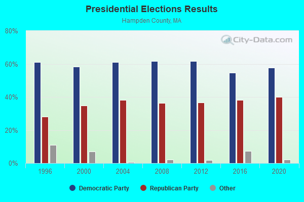
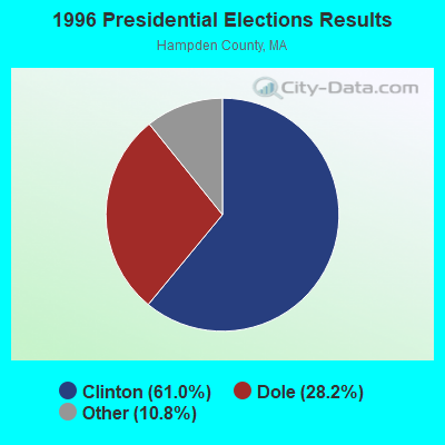
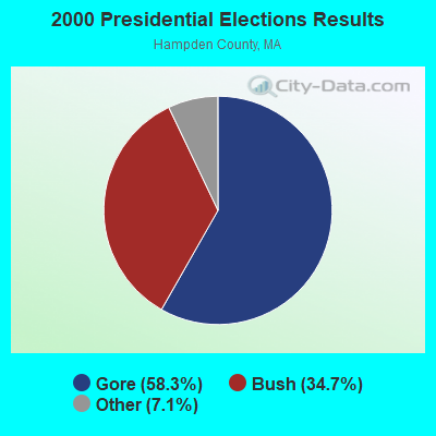
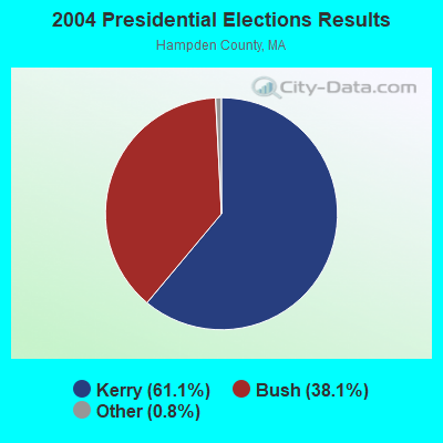
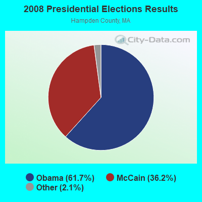
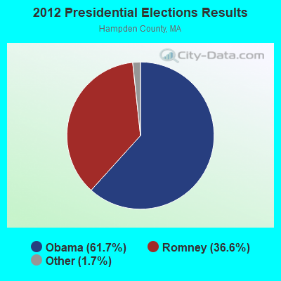
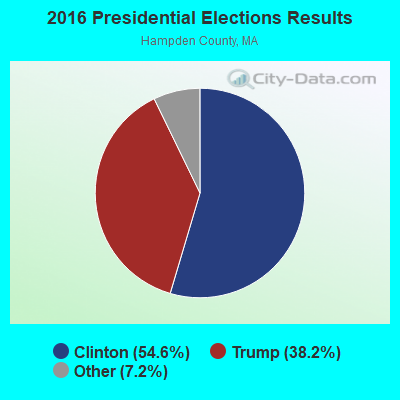
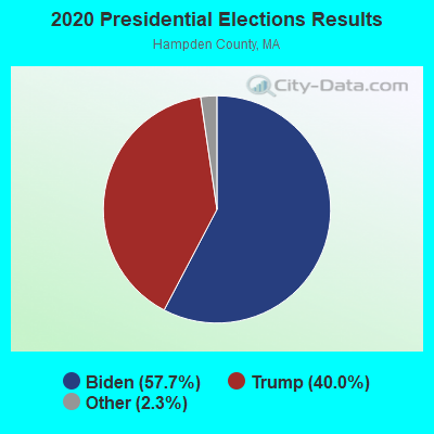
Graphs represent county-level data. Detailed 2008 Election Results
Religion statistics for Tolland, MA (based on Hampden County data)
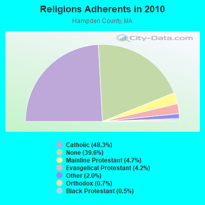
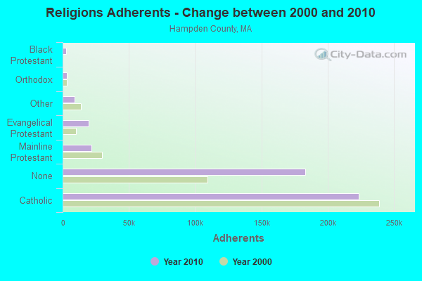
| Religion | Adherents | Congregations |
|---|---|---|
| Catholic | 223,685 | 65 |
| Mainline Protestant | 21,962 | 88 |
| Evangelical Protestant | 19,438 | 114 |
| Other | 9,140 | 31 |
| Orthodox | 3,406 | 10 |
| Black Protestant | 2,491 | 16 |
| None | 183,368 | - |
Food Environment Statistics:
| Here: | 1.95 / 10,000 pop. |
| State: | 1.98 / 10,000 pop. |
| Hampden County: | 0.04 / 10,000 pop. |
| Massachusetts: | 0.05 / 10,000 pop. |
| This county: | 1.87 / 10,000 pop. |
| Massachusetts: | 2.22 / 10,000 pop. |
| Hampden County: | 2.43 / 10,000 pop. |
| Massachusetts: | 1.77 / 10,000 pop. |
| Here: | 7.27 / 10,000 pop. |
| State: | 8.76 / 10,000 pop. |
| Hampden County: | 9.2% |
| Massachusetts: | 8.1% |
| Hampden County: | 25.9% |
| State: | 22.5% |
| Hampden County: | 16.2% |
| Massachusetts: | 16.5% |
3.64% of this county's 2021 resident taxpayers lived in other counties in 2020 ($58,474 average adjusted gross income)
| Here: | 3.64% |
| Massachusetts average: | 6.35% |
0.02% of residents moved from foreign countries ($105 average AGI)
Hampden County: 0.02% Massachusetts average: 0.01%
Top counties from which taxpayers relocated into this county between 2020 and 2021:
| from Hampshire County, MA | |
| from Hartford County, CT | |
| from Worcester County, MA |
4.26% of this county's 2020 resident taxpayers moved to other counties in 2021 ($66,146 average adjusted gross income)
| Here: | 4.26% |
| Massachusetts average: | 7.18% |
0.03% of residents moved to foreign countries ($223 average AGI)
Hampden County: 0.03% Massachusetts average: 0.02%
Top counties to which taxpayers relocated from this county between 2020 and 2021:
| to Hampshire County, MA | |
| to Hartford County, CT | |
| to Worcester County, MA |
Strongest AM radio stations in Tolland:
- WNNZ (640 AM; 50 kW; WESTFIELD, MA; Owner: CLEAR CHANNEL BROADCASTING LICENSES, INC.)
- WTIC (1080 AM; 50 kW; HARTFORD, CT; Owner: INFINITY RADIO OPERATIONS INC.)
- WHYN (560 AM; 5 kW; SPRINGFIELD, MA; Owner: CLEAR CHANNEL BROADCASTING LICENSES, INC.)
- WCRN (830 AM; 50 kW; WORCESTER, MA; Owner: CARTER BROADCASTING CORPORATION)
- WACE (730 AM; 5 kW; CHICOPEE, MA; Owner: CARTER BROADCASTING CORP.)
- WVNE (760 AM; daytime; 25 kW; LEICESTER, MA; Owner: BLOUNT MASSCOM, INC.)
- WGY (810 AM; 50 kW; SCHENECTADY, NY; Owner: CLEAR CHANNEL BROADCASTING LICENSES, INC.)
- WSPR (1270 AM; 5 kW; SPRINGFIELD, MA; Owner: ANTONIO F. AND HELENA R. GOIS, TENANTS BY THE ENTIRETY)
- WALE (990 AM; 50 kW; GREENVILLE, RI; Owner: NORTH AMERICAN BROADCASTING CO., INC.)
- WSBS (860 AM; 3 kW; GREAT BARRINGTON, MA; Owner: BERKSHIRE BROADCASTING CO., INC.)
- WPTR (1540 AM; 50 kW; ALBANY, NY; Owner: KIMTRON, INC.)
- WFAN (660 AM; 50 kW; NEW YORK, NY; Owner: INFINITY BROADCASTING OPERATIONS, INC.)
- WRKO (680 AM; 50 kW; BOSTON, MA; Owner: ENTERCOM BOSTON LICENSE, LLC)
Strongest FM radio stations in Tolland:
- WAQY (102.1 FM; SPRINGFIELD, MA; Owner: SAGA COMMUNICATIONS OF NEW ENGLAND, LLC)
- WHYN-FM (93.1 FM; SPRINGFIELD, MA; Owner: CLEAR CHANNEL BROADCASTING LICENSES, INC.)
- WRCH (100.5 FM; NEW BRITAIN, CT; Owner: INFINITY RADIO OPERATIONS INC.)
- WAMC-FM (90.3 FM; ALBANY, NY; Owner: WAMC)
- WRNX (100.9 FM; AMHERST, MA; Owner: WESTERN MASSACHUSETTS RADIO COMPANY)
- WAMQ (105.1 FM; GREAT BARRINGTON, MA; Owner: WAMC)
- WPKX (97.9 FM; ENFIELD, CT; Owner: CAPSTAR TX LIMITED PARTNERSHIP)
- WHVP (91.1 FM; HUDSON, NY; Owner: SOUND OF LIFE, INC.)
- WTIC-FM (96.5 FM; HARTFORD, CT; Owner: INFINITY RADIO OPERATIONS INC.)
- WWUH (91.3 FM; WEST HARTFORD, CT; Owner: UNIVERSITY OF HARTFORD)
- WCCC-FM (106.9 FM; HARTFORD, CT; Owner: MARLIN BROADCASTING, LLC)
- WJMJ (88.9 FM; HARTFORD, CT; Owner: ST. THOMAS SEMINARY)
- WSGG (89.3 FM; NORFOLK, CT; Owner: REVIVAL CHRISTIAN MINISTRIES, INC.)
- WFCR (88.5 FM; AMHERST, MA; Owner: UNIVERSITY OF MASSACHUSETTS)
- WBEC-FM (105.5 FM; PITTSFIELD, MA; Owner: GREAT NORTHERN RADIO, LLC)
- WPDH (101.5 FM; POUGHKEEPSIE, NY; Owner: CUMULUS LICENSING CORP.)
- WWYZ (92.5 FM; WATERBURY, CT; Owner: CAPSTAR TX LIMITED PARTNERSHIP)
- WKSS (95.7 FM; HARTFORD-MERIDEN, CT; Owner: CAPSTAR TX LIMITED PARTNERSHIP)
- WZMX (93.7 FM; HARTFORD, CT; Owner: INFINITY RADIO OPERATIONS INC.)
- WHCN (105.9 FM; HARTFORD, CT; Owner: CAPSTAR TX LIMITED PARTNERSHIP)
TV broadcast stations around Tolland:
- WTIC-TV (Channel 61; HARTFORD, CT; Owner: TRIBUNE TELEVISION COMPANY)
- W11BJ (Channel 11; HARTFORD, CT; Owner: COMMUNICATIONS SITE MANAGEMENT LLC)
- WUVN (Channel 18; HARTFORD, CT; Owner: ENTRAVISION HOLDINGS, LLC)
- WTXX (Channel 20; WATERBURY, CT; Owner: WTXX INC.)
- WVIT (Channel 30; NEW BRITAIN, CT; Owner: OUTLET BROADCASTING, INC)
- WEDH (Channel 24; HARTFORD, CT; Owner: CONNECTICUT PUBLIC BROADCASTING, INC.)
- WWLP (Channel 22; SPRINGFIELD, MA; Owner: WWLP BROADCASTING, LLC)
- WFSB (Channel 3; HARTFORD, CT; Owner: MEREDITH CORPORATION)
- WYDN (Channel 48; WORCESTER, MA; Owner: EDUCATIONAL PUBLIC TV CORPORATION)
- W67DF (Channel 67; SPRINGFIELD, MA; Owner: TRINITY BROADCASTING NETWORK)
- WHCT-LP (Channel 38; HARTFORD, CT; Owner: VENTURE TECHNOLOGIES GROUP, LLC)
- WDMR-LP (Channel 65; SPRINGFIELD, MA; Owner: ZGS HARTFORD, INC.)
Tolland fatal accident list:
Oct 20, 1989 09:26 AM, Route 57, Vehicles: 1, Persons: 2, Fatalities: 1
- National Bridge Inventory (NBI) Statistics
- 1Number of bridges
- 3ft / 0.8mTotal length
- 120Total average daily traffic
- 7Total average daily truck traffic
FCC Registered Antenna Towers:
6- Edward G Roach, 162 Colebrook River Rd. (Ma11688-S) (Lat: 42.076139 Lon: -73.013194), Type: 54.9, Overall height: 47.2 m, Registrant: Sba Towers Ii LLC, Eroach@sbasite.Com, , Boca -Raton, Phone: (561) 995-7670
- Edward G Roach, 162 Colebrook River Rd. (Ma11688-S) (Lat: 42.076139 Lon: -73.013194), Type: 54.9, Overall height: 47.2 m, Registrant: Sba Towers Ii LLC, Eroach@sbasite.Com, , Boca -Raton, Phone: (561) 995-7670
- Edward G Roach, 162 Colebrook River Rd. (Ma11688-S) (Lat: 42.076139 Lon: -73.013194), Type: 49.7, Overall height: 48.2 m, Registrant: Sba Towers Ii LLC, Eroach@sbasite.Com, , Boca -Raton, Phone: (561) 995-7670
- Edward G Roach, 162 Colebrook River Rd. (Ma11688-S) (Lat: 42.076139 Lon: -73.013194), Type: 49.7, Overall height: 48.2 m, Registrant: Sba Towers Ii LLC, Eroach@sbasite.Com, , Boca -Raton, Phone: (561) 995-7670
- Edward G Roach, 162 Colebrook River Road (Ma11688-S) (Lat: 42.076139 Lon: -73.013194), Type: 49.7, Structure height: 25013 m, Overall height: 48.2 m, Registrant: Sba Towers Viii, LLC, Eroach@sbasite.Com, , Boca -Raton, Phone: (561) 995-7670
- Edward G Roach, 162 Colebrook River Road (Ma11688-S) (Lat: 42.076139 Lon: -73.013194), Type: 49.7, Structure height: 25013 m, Overall height: 48.2 m, Registrant: Sba Towers Viii, LLC, Eroach@sbasite.Com, , Boca -Raton, Phone: (561) 995-7670
FCC Registered Broadcast Land Mobile Towers:
1- Burt Hill Rd (Lat: 42.074806 Lon: -73.038167), Call Sign: KNCZ364,
Assigned Frequencies: 155.985 MHz, Grant Date: 12/09/1996, Expiration Date: 02/19/2002, Cancellation Date: 05/05/2002, Registrant: Tolland, Town Of, Burt Hill Rd, Tolland, MA 01034, Phone: (413) 258-4531
FCC Registered Microwave Towers:
1- TOLLAND-E OTIS RD, E Otis Rd (Lat: 42.095250 Lon: -73.062278), Type: Mast, Structure height: 60.9 m, Call Sign: WSBR934,
Assigned Frequencies: 11425.0 MHz, 6256.54 MHz, Grant Date: 03/07/2024, Expiration Date: 03/07/2034, Certifier: Matthew M Barstow, Registrant: Massachusetts, Commonwealth Of, 470 Worcester Rd, Framingham, MA 01702, Phone: (508) 820-2264, Email:
FCC Registered Amateur Radio Licenses:
5- Call Sign: KB1CEI, Licensee ID: L01283616, Grant Date: 06/07/2017, Expiration Date: 06/17/2027, Certifier: Joseph J Clark Iv, Registrant: Joseph J Clark Iv Iv, 927 Burt Hill Rd, Tolland, MA 01034-9565
- Call Sign: W1SQZ, Licensee ID: L01156193, Grant Date: 09/01/2016, Expiration Date: 10/03/2026, Certifier: James A Warren, Registrant: James A Warren, 132 Brook Ln, Tolland, MA 01034
- Call Sign: KB1EVM, Licensee ID: L00211576, Grant Date: 02/25/2000, Expiration Date: 02/25/2010, Cancellation Date: 10/11/2000, Certifier: Ian O Mcalister, Registrant: Ian O Mcalister, 103 Hartland Rd, Tolland, MA 01034
- Call Sign: K3OQ, Previous Call Sign: KB1EVM, Licensee ID: L00211576, Grant Date: 10/11/2000, Expiration Date: 10/11/2010, Cancellation Date: 04/07/2001, Certifier: Ian O Mc Alister, Registrant: Ian O Mcalister, 103 Hartland R, Tolland, MA 01034
- Call Sign: KC1DKU, Licensee ID: L01930267, Grant Date: 03/19/2015, Expiration Date: 03/19/2025, Certifier: Blaire A Hermans, Registrant: Blaire A Hermans, 430 Colebrook River Rd, Tolland, MA 01034

- 53.4%Fuel oil, kerosene, etc.
- 17.8%Wood
- 15.1%Bottled, tank, or LP gas
- 8.9%Electricity
- 3.4%Utility gas
- 1.4%Solar energy

- 52.0%Electricity
- 48.0%Fuel oil, kerosene, etc.
Tolland compared to Massachusetts state average:
- Unemployed percentage significantly below state average.
- Black race population percentage significantly below state average.
- Hispanic race population percentage significantly below state average.
- Median age significantly above state average.
- Foreign-born population percentage significantly below state average.
- Renting percentage significantly below state average.
- Length of stay since moving in significantly above state average.
- Number of rooms per house significantly below state average.
- House age significantly below state average.
- Number of college students significantly below state average.

|
Total of 1 patent application in 2008-2024.