Tioga, New York

Submit your own pictures of this town and show them to the world
- OSM Map
- Google Map
- MSN Map
Population change since 2000: +0.6%
 |
| Males: 2,395 | |
| Females: 2,476 |
| Median resident age: | 42.3 years |
| New York median age: | 40.7 years |
Zip codes: 13734.
| Tioga: | $63,192 |
| NY: | $79,557 |
Estimated per capita income in 2022: $36,144 (it was $17,813 in 2000)
Tioga town income, earnings, and wages data
Estimated median house or condo value in 2022: $118,152 (it was $57,300 in 2000)
| Tioga: | $118,152 |
| NY: | $400,400 |
Mean prices in 2022: all housing units: $170,685; detached houses: $186,161; townhouses or other attached units: $222,970; in 2-unit structures: $206,784; in 3-to-4-unit structures: $181,057; in 5-or-more-unit structures: $284,269; mobile homes: $85,353; occupied boats, rvs, vans, etc.: $58,014
Detailed information about poverty and poor residents in Tioga, NY


- 4,73297.1%White alone
- 581.2%Hispanic
- 390.8%Two or more races
- 130.3%Black alone
- 170.3%Asian alone
- 120.2%American Indian alone

Races in Tioga detailed stats: ancestries, foreign born residents, place of birth
 Recent articles from our blog. Our writers, many of them Ph.D. graduates or candidates, create easy-to-read articles on a wide variety of topics.
Ancestries: German (23.7%), English (20.2%), Irish (12.6%), United States (10.6%), Italian (6.2%), Dutch (5.3%).
Current Local Time: EST time zone
Land area: 58.7 square miles.
Population density: 83 people per square mile (very low).
27 residents are foreign born
| This town: | 0.6% |
| New York: | 20.4% |
| Tioga town: | 2.4% ($1,364) |
| New York: | 1.9% ($2,847) |
Nearest city with pop. 50,000+: Union, NY (17.7 miles  , pop. 56,298).
Nearest city with pop. 200,000+: Rochester, NY (97.8 miles , pop. 219,773).
Nearest city with pop. 1,000,000+: Manhattan, NY (154.0 miles , pop. 1,537,195).
Nearest cities:
), ), Latitude: 42.09 N, Longitude: 76.36 W
Area code commonly used in this area: 607

Single-family new house construction building permits:
- 2022: 4 buildings, average cost: $170,000
- 2021: 6 buildings, average cost: $180,000
- 2020: 5 buildings, average cost: $180,000
- 2019: 8 buildings, average cost: $100,000
- 2018: 10 buildings, average cost: $126,000
- 2017: 9 buildings, average cost: $100,000
- 2016: 3 buildings, average cost: $103,300
- 2015: 8 buildings, average cost: $187,500
- 2014: 12 buildings, average cost: $125,000
- 2013: 10 buildings, average cost: $100,000
- 2012: 17 buildings, average cost: $129,400
- 2011: 16 buildings, average cost: $75,000
- 2010: 2 buildings, average cost: $300,000
- 2009: 13 buildings, average cost: $115,400
- 2008: 15 buildings, average cost: $150,000
- 2007: 17 buildings, average cost: $70,600
- 2006: 8 buildings, average cost: $225,000
- 2005: 9 buildings, average cost: $225,000
- 2004: 5 buildings, average cost: $150,000
- 2003: 8 buildings, average cost: $106,300
- 2002: 5 buildings, average cost: $160,000
- 2001: 5 buildings, average cost: $125,000
- 2000: 4 buildings, average cost: $143,800
- 1999: 8 buildings, average cost: $117,500
- 1998: 5 buildings, average cost: $90,000
- 1997: 8 buildings, average cost: $68,800


| Here: | 4.0% |
| New York: | 4.4% |


- Computer & electronic products (14.4%)
- Educational services (9.9%)
- Construction (7.3%)
- Health care (5.8%)
- Public administration (4.4%)
- Administrative & support & waste management services (4.2%)
- Metal & metal products (3.9%)

- Computer & electronic products (13.5%)
- Construction (12.3%)
- Metal & metal products (7.2%)
- Transportation equipment (5.8%)
- Educational services (4.9%)
- Building material & garden equipment & supplies dealers (3.8%)
- Agriculture, forestry, fishing & hunting (3.7%)

- Educational services (15.6%)
- Computer & electronic products (15.4%)
- Health care (9.8%)
- Administrative & support & waste management services (6.3%)
- Finance & insurance (5.7%)
- Public administration (5.6%)
- Social assistance (4.8%)

- Metal workers and plastic workers (7.1%)
- Assemblers and fabricators (4.9%)
- Other management occupations, except farmers and farm managers (4.4%)
- Engineers (4.0%)
- Electrical equipment mechanics and other installation, maintenance, and repair workers, including supervisors (4.0%)
- Bookkeeping, accounting, and auditing clerks (3.4%)
- Other production occupations, including supervisors (3.4%)

- Metal workers and plastic workers (10.3%)
- Electrical equipment mechanics and other installation, maintenance, and repair workers, including supervisors (7.4%)
- Engineers (6.8%)
- Assemblers and fabricators (5.3%)
- Other management occupations, except farmers and farm managers (5.3%)
- Building and grounds cleaning and maintenance occupations (4.8%)
- Driver/sales workers and truck drivers (3.7%)

- Bookkeeping, accounting, and auditing clerks (7.3%)
- Preschool, kindergarten, elementary, and middle school teachers (5.9%)
- Other sales and related occupations, including supervisors (5.0%)
- Other office and administrative support workers, including supervisors (4.3%)
- Assemblers and fabricators (4.3%)
- Retail sales workers, except cashiers (4.2%)
- Secretaries and administrative assistants (3.8%)
Average climate in Tioga, New York
Based on data reported by over 4,000 weather stations


(lower is better)

Air Quality Index (AQI) level in 2012 was 55.3. This is better than average.
| City: | 55.3 |
| U.S.: | 72.6 |

Sulfur Dioxide (SO2) [ppb] level in 2012 was 1.48. This is about average. Closest monitor was 20.7 miles away from the city center.
| City: | 1.48 |
| U.S.: | 1.51 |

Ozone [ppb] level in 2012 was 25.6. This is better than average. Closest monitor was 22.5 miles away from the city center.
| City: | 25.6 |
| U.S.: | 33.3 |
Tornado activity:
Tioga-area historical tornado activity is near New York state average. It is 59% smaller than the overall U.S. average.
On 5/2/1983, a category F3 (max. wind speeds 158-206 mph) tornado 2.9 miles away from the Tioga town center injured 6 people and caused between $500,000 and $5,000,000 in damages.
On 5/2/1983, a category F3 tornado 10.6 miles away from the town center injured one person and caused between $500,000 and $5,000,000 in damages.
Earthquake activity:
Tioga-area historical earthquake activity is significantly above New York state average. It is 66% smaller than the overall U.S. average.On 10/7/1983 at 10:18:46, a magnitude 5.3 (5.1 MB, 5.3 LG, 5.1 ML, Class: Moderate, Intensity: VI - VII) earthquake occurred 164.5 miles away from the city center
On 8/23/2011 at 17:51:04, a magnitude 5.8 (5.8 MW, Depth: 3.7 mi) earthquake occurred 300.9 miles away from Tioga center
On 4/20/2002 at 10:50:47, a magnitude 5.3 (5.3 ML, Depth: 3.0 mi) earthquake occurred 214.6 miles away from the city center
On 9/25/1998 at 19:52:52, a magnitude 5.2 (4.8 MB, 4.3 MS, 5.2 LG, 4.5 MW, Depth: 3.1 mi) earthquake occurred 212.0 miles away from the city center
On 4/20/2002 at 10:50:47, a magnitude 5.2 (5.2 MB, 4.2 MS, 5.2 MW, 5.0 MW) earthquake occurred 212.6 miles away from the city center
On 1/16/1994 at 01:49:16, a magnitude 4.6 (4.6 MB, 4.6 LG, Depth: 3.1 mi, Class: Light, Intensity: IV - V) earthquake occurred 123.0 miles away from Tioga center
Magnitude types: regional Lg-wave magnitude (LG), body-wave magnitude (MB), local magnitude (ML), surface-wave magnitude (MS), moment magnitude (MW)
Natural disasters:
The number of natural disasters in Tioga County (23) is greater than the US average (15).Major Disasters (Presidential) Declared: 13
Emergencies Declared: 7
Causes of natural disasters: Storms: 11, Floods: 10, Tropical Storms: 3, Hurricanes: 2, Snowstorms: 2, Winds: 2, Blizzard: 1, Heavy Rain: 1, Landslide: 1, Power Outage: 1, Tornado: 1, Tropical Depression: 1, Winter Storm: 1, Other: 2 (Note: some incidents may be assigned to more than one category).
Hospitals and medical centers near Tioga:
- TIOGA COUNTY HOSPICE (Hospital, about 5 miles away; OWEGO, NY)
- ELDERWOOD HEALTH CARE AT TIOGA (Nursing Home, about 11 miles away; WAVERLY, NY)
- SAYRE HEALTH CARE CENTER (Nursing Home, about 11 miles away; SAYRE, PA)
- ASHTON HEALTHCARE (Nursing Home, about 13 miles away; ATHENS, PA)
- HERITAGE NURSING HOME INC (Nursing Home, about 13 miles away; ATHENS, PA)
- IDEAL SENIOR LIVING CENTER (Nursing Home, about 16 miles away; ENDICOTT, NY)
- ABSOLUT CTR FOR NURSING AND REHAB ENDICOTT L L C (Nursing Home, about 16 miles away; ENDICOTT, NY)
Colleges/universities with over 2000 students nearest to Tioga:
- SUNY at Binghamton (about 21 miles; Vestal, NY; Full-time enrollment: 15,096)
- SUNY Broome Community College (about 24 miles; Binghamton, NY; FT enrollment: 4,969)
- Ithaca College (about 24 miles; Ithaca, NY; FT enrollment: 6,781)
- Cornell University (about 26 miles; Ithaca, NY; FT enrollment: 20,360)
- Tompkins Cortland Community College (about 29 miles; Dryden, NY; FT enrollment: 3,884)
- SUNY College at Cortland (about 36 miles; Cortland, NY; FT enrollment: 6,838)
- Corning Community College (about 37 miles; Corning, NY; FT enrollment: 3,036)
Public high school in Tioga:
- TIOGA SENIOR HIGH SCHOOL (Students: 341, Location: 27 5TH AVE, Grades: 9-12)
Public elementary/middle schools in Tioga:
- TIOGA MIDDLE SCHOOL (Students: 336, Location: 27 5TH AVE, Grades: 5-8)
- TIOGA ELEMENTARY SCHOOL (Students: 305, Location: 41 5TH AVE, Grades: PK-4)
Private elementary/middle school in Tioga:
- TIOGA CENTER CHRISTIAN SCHOOL (Students: 14, Location: 99 HALSEY VALLEY RD, Grades: PK-3)
Points of interest:
Notable locations in Tioga: Mountain Top Greenhouses (A), Wildrose Farm (B), Tioga Fire Company (C), Tioga Center Fire Department (D). Display/hide their locations on the map
Churches in Tioga include: Tioga Center Baptist Church (A), Church of the Nazarene (B), Tioga Center United Methodist Church (C), Assembly of God Church (D), Zion Lutheran Church (E). Display/hide their locations on the map
Cemeteries: Saint Patricks Cemetery (1), Beaver Meadows Cemetery (2), Tioga Cemetery (3), Light Cemetery (4), Smithboro Cemetery (5), Smithboro Methodist Cemetery (6), Tioga Center Cemetery (7). Display/hide their locations on the map
Lake: Zorn Pond (A). Display/hide its location on the map
Streams, rivers, and creeks: Pipe Creek (A), Dry Brook (B), Evelin Hill Creek (C), Catatonk Creek (D), Chambers Creek (E). Display/hide their locations on the map
| This town: | 2.5 people |
| New York: | 2.6 people |
| This town: | 69.9% |
| Whole state: | 63.5% |
| This town: | 10.0% |
| Whole state: | 6.8% |
Likely homosexual households (counted as self-reported same-sex unmarried-partner households)
- Lesbian couples: 0.3% of all households
- Gay men: 0.3% of all households
| This town: | 6.5% |
| Whole state: | 14.6% |
| This town: | 3.7% |
| Whole state: | 7.4% |
For population 15 years and over in Tioga:

- Never married: 20.8%
- Now married: 60.7%
- Separated: 2.7%
- Widowed: 5.7%
- Divorced: 10.1%
For population 25 years and over in Tioga:
- High school or higher: 78.1%
- Bachelor's degree or higher: 15.0%
- Graduate or professional degree: 6.5%
- Unemployed: 6.5%
- Mean travel time to work (commute): 28.9 minutes


| Here: | 10.5 |
| New York average: | 14.2 |
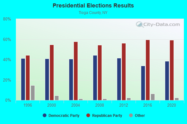
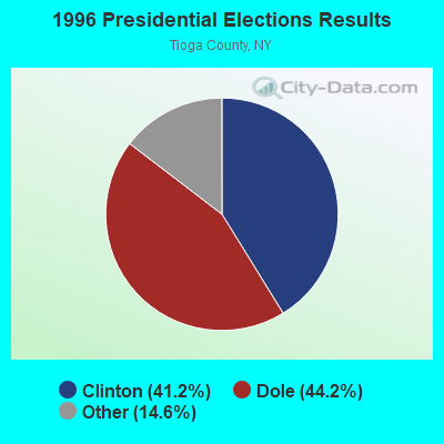
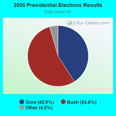
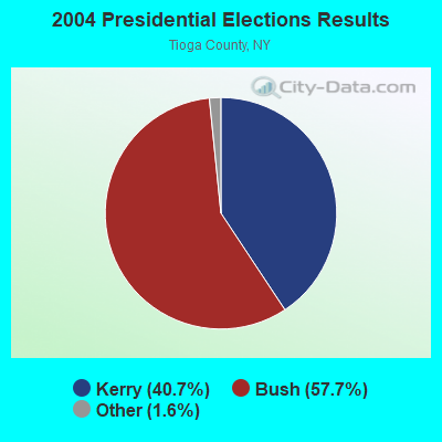

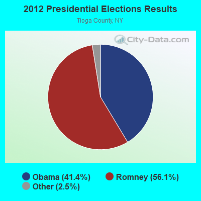
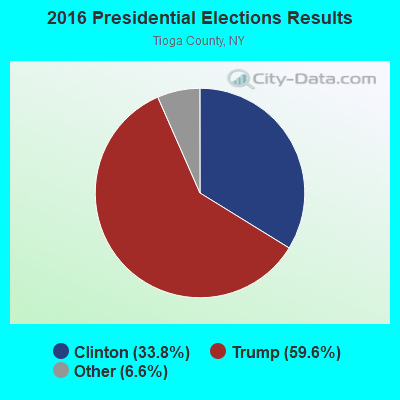
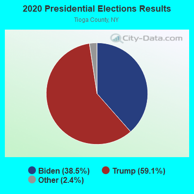
Graphs represent county-level data. Detailed 2008 Election Results
Religion statistics for Tioga, NY (based on Tioga County data)
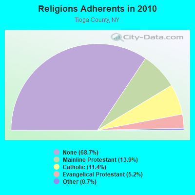
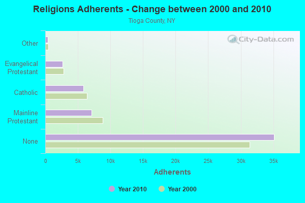
| Religion | Adherents | Congregations |
|---|---|---|
| Mainline Protestant | 7,115 | 36 |
| Catholic | 5,831 | 2 |
| Evangelical Protestant | 2,673 | 30 |
| Other | 366 | 4 |
| None | 35,140 | - |
Food Environment Statistics:
| Here: | 2.58 / 10,000 pop. |
| New York: | 4.13 / 10,000 pop. |
| Tioga County: | 0.20 / 10,000 pop. |
| State: | 0.92 / 10,000 pop. |
| Tioga County: | 3.37 / 10,000 pop. |
| New York: | 1.68 / 10,000 pop. |
| Tioga County: | 7.35 / 10,000 pop. |
| New York: | 8.82 / 10,000 pop. |
| Tioga County: | 7.7% |
| State: | 8.2% |
| This county: | 27.6% |
| State: | 23.8% |
| This county: | 14.9% |
| New York: | 15.6% |
Strongest AM radio stations in Tioga:
- WEBO (1330 AM; 5 kW; OWEGO, NY; Owner: TIOGA MEDIA, INC.)
- WATS (960 AM; 5 kW; SAYRE, PA; Owner: WATS BROADCASTING, INC.)
- WNBF (1290 AM; 9 kW; BINGHAMTON, NY; Owner: CITADEL BROADCASTING COMPANY)
- WENE (1430 AM; 5 kW; ENDICOTT, NY; Owner: CLEAR CHANNEL BROADCASTING LICENSES, INC.)
- WINR (680 AM; 5 kW; BINGHAMTON, NY; Owner: CLEVELAND RADIO LICENSES, LLC)
- WHCU (870 AM; 5 kW; ITHACA, NY; Owner: EAGLE BROADCASTING COMPANY, INC.)
- WLNL (1000 AM; daytime; 5 kW; HORSEHEADS, NY; Owner: LIGHTHOUSE MEDIA, INC.)
- WWLZ (820 AM; 4 kW; HORSEHEADS, NY; Owner: CHEMUNG COUNTY RADIO, INC.)
- WTKO (1470 AM; 5 kW; ITHACA, NY; Owner: EAGLE II BROADCASTING CORPORATION)
- WELM (1410 AM; 5 kW; ELMIRA, NY; Owner: PEMBROOK PINES ELMIRA, LIMITED)
- WYOS (1360 AM; 5 kW; BINGHAMTON, NY; Owner: CITADEL BROADCASTING COMPANY)
- WEHH (1590 AM; 5 kW; ELMIRA HTS/HORSEHEAD, NY; Owner: PEMBROOK PINES ELMIRA, LTD.)
- WHAM (1180 AM; 50 kW; ROCHESTER, NY; Owner: CITICASTERS LICENSES, L.P.)
Strongest FM radio stations in Tioga:
- WCII (88.5 FM; SPENCER, NY; Owner: FAMILY LIFE MINISTRIES, INC.)
- WLTB (101.7 FM; JOHNSON CITY, NY; Owner: GM BROADCASTING, INC.)
- WAVR (102.3 FM; WAVERLY, NY; Owner: WATS BROADCASTING, INC.)
- WHWK (98.1 FM; BINGHAMTON, NY; Owner: CITADEL BROADCASTING COMPANY)
- WAAL (99.1 FM; BINGHAMTON, NY; Owner: CITADEL BROADCASTING COMPANY)
- WSKG-FM (89.3 FM; BINGHAMTON, NY; Owner: WSKG PUB.TELECOMMUNICATIONS COUNCIL)
- WMXW (103.3 FM; VESTAL, NY; Owner: CLEAR CHANNEL BROADCASTING LICENSES, INC.)
- WWYL (104.1 FM; CHENANGO BRIDGE, NY; Owner: CITADEL BROADCASTING COMPANY)
- WSQX-FM (91.5 FM; BINGHAMTON, NY; Owner: WSKG PUBLIC TELECOMMUNICATIONS CNCL.)
- WLVY (94.3 FM; ELMIRA, NY; Owner: PEMBROOK PINES ELMIRA, LTD.)
- WOKN (99.5 FM; SOUTHPORT, NY; Owner: PEMBROOK PINES ELMIRA, LTD.)
- WQNY (103.7 FM; ITHACA, NY; Owner: EAGLE II BROADCASTING CORPORATION)
- WENY-FM (92.7 FM; ELMIRA, NY; Owner: EOLIN BROADCASTING, INC.)
- WYXL (97.3 FM; ITHACA, NY; Owner: EAGLE BROADCASTING COMPANY)
- WMRV-FM (105.7 FM; ENDICOTT, NY; Owner: CLEAR CHANNEL BROADCASTING LICENSES, INC.)
- WBBI (107.5 FM; ENDWELL, NY; Owner: CLEAR CHANNEL BROADCASTING LICENSES, INC.)
- W273AB (102.5 FM; OWEGO, NY; Owner: WEBO RADIO, INC.)
- W205BR (88.9 FM; ELMIRA, NY; Owner: PENSACOLA CHRISTIAN COLLEGE, INC.)
- WKGB-FM (92.5 FM; CONKLIN, NY; Owner: CLEAR CHANNEL BROADCASTING LICENSES, INC.)
- WSQE (91.1 FM; CORNING, NY; Owner: WSKG PUB. TELECOMMUNICATIONS COUNCIL)
TV broadcast stations around Tioga:
- WSKG-TV (Channel 46; BINGHAMTON, NY; Owner: WSKG PUBLIC TELECOMMUNICATIONS COUNCIL)
- WICZ-TV (Channel 40; BINGHAMTON, NY; Owner: STAINLESS BROADCASTING, L.P.)
- WBNG-TV (Channel 12; BINGHAMTON, NY; Owner: TELEVISION STATION GROUP LICENSE SUBSIDIARY, LLC)
- WETM-TV (Channel 18; ELMIRA, NY; Owner: SMITH TELEVISION OF NEW YORK LICENSE HOLDINGS, INC.)
- W52CE (Channel 52; SAYRE, PA; Owner: WOLF LICENSE CORP.)
- W26BS (Channel 14; BINGHAMTON, NY; Owner: TRINITY BROADCASTING NETWORK)
- WIVT (Channel 34; BINGHAMTON, NY; Owner: CENTRAL NY NEWS, INC.)
- WBPN-LP (Channel 10; BINGHAMTON, NY; Owner: STAINLESS BROADCASTING, L.P.)
- WENY-TV (Channel 36; ELMIRA, NY; Owner: LILLY BROADCASTING, L.L.C.)
- W59DG (Channel 59; ELMIRA, NY; Owner: TRINITY BROADCASTING NETWORK)
- WBGH-CA (Channel 20; BINGHAMTON, NY; Owner: CENTRAL NY NEWS, INC.)
- W21BW (Channel 21; ELMIRA, NY; Owner: THREE ANGELS BROADCASTING NETWORK INC.)
- National Bridge Inventory (NBI) Statistics
- 23Number of bridges
- 197ft / 59.9mTotal length
- $28,779,000Total costs
- 27,189Total average daily traffic
- 2,509Total average daily truck traffic

- New bridges - historical statistics
- 11910-1919
- 21930-1939
- 21940-1949
- 21950-1959
- 21960-1969
- 11970-1979
- 51980-1989
- 41990-1999
- 12000-2009
- 22010-2019
- 12020-2022
FCC Registered Antenna Towers:
6- Brian J Hargraves, 2601 Rte. 17 C (Lat: 42.033417 Lon: -76.366917), Type: 60.6, Overall height: 54.9 m, Registrant: American Tower Corporation, Www.Americantower.Com, , Bosto-n, Phone: (617) 585-7600
- Brian J Hargraves, 2601 Rte. 17 C (Lat: 42.033417 Lon: -76.366917), Type: 60.6, Overall height: 54.9 m, Registrant: American Tower Corporation, Www.Americantower.Com, , Bosto-n, Phone: (617) 585-7600
- Sean O'Malley, 2601 Rte. 17 C (Lat: 42.033417 Lon: -76.366917), Type: 60.6, Overall height: 54.9 m, Registrant: American Towers, Inc., Bosto-n, Phone: (617) 585-7600
- Tim McDougall, 2601 Rte. 17 C (010286) (Lat: 42.033417 Lon: -76.366917), Type: 60.6, Overall height: 60.6 m, Registrant: Faa/Fcc Compliance Specialist, Bosto-n, Phone: (617) 585-7600
- Tim McDougall, 2601 Rte. 17 C (010286) (Lat: 42.033417 Lon: -76.366917), Type: 60.6, Overall height: 60.6 m, Registrant: American Tower, L.P., Bosto-n, Phone: (617) 585-7600
- Sean O'Malley, 2601 Rte. 17 C (010286) (Lat: 42.033417 Lon: -76.366917), Type: 60.6, Overall height: 60.6 m, Registrant: American Towers, Inc., Bosto-n, Phone: (617) 585-7600
FCC Registered Broadcast Land Mobile Towers:
1- Spaulding Hill Road (Lat: 42.143417 Lon: -76.342722), Call Sign: WSQ991,
Assigned Frequencies: 39.9800 MHz, Grant Date: 03/07/2015, Expiration Date: 05/31/2025, Registrant: Tioga County Of, 103 Corporate Drive, Lower Level, Owego, NY 13827, Phone: (607) 687-2023, Email:
FCC Registered Microwave Towers:
1- Ballou Rd, 61 Ballou Rd (Lat: 42.123889 Lon: -76.290444), Type: Gtower, Structure height: 36.6 m, Call Sign: WQXC213,
Assigned Frequencies: 6389.96 MHz, 19540.0 MHz, 11645.0 MHz, 19540.0 MHz, 11645.0 MHz, 6389.96 MHz, 19540.0 MHz, 11645.0 MHz, 6389.96 MHz, 6389.96 MHz... (+49 more), Grant Date: 01/27/2016, Expiration Date: 01/27/2026, Certifier: John Scott, Registrant: Tioga County Of, 103 Corporate Drive, Lower Level, Owego, NY 13827, Phone: (607) 687-2023, Fax: (585) 924-8842, Email:

- 49.4%Fuel oil, kerosene, etc.
- 19.4%Utility gas
- 12.1%Bottled, tank, or LP gas
- 10.0%Wood
- 5.2%Electricity
- 3.4%Coal or coke
- 0.5%Other fuel

- 38.5%Fuel oil, kerosene, etc.
- 25.1%Utility gas
- 24.9%Bottled, tank, or LP gas
- 7.4%Wood
- 4.1%Electricity
Tioga compared to New York state average:
- Median house value significantly below state average.
- Unemployed percentage below state average.
- Black race population percentage significantly below state average.
- Hispanic race population percentage significantly below state average.
- Foreign-born population percentage significantly below state average.
- Renting percentage significantly below state average.
- Length of stay since moving in significantly above state average.
- Number of rooms per house significantly below state average.
- House age significantly below state average.
- Number of college students below state average.
- Percentage of population with a bachelor's degree or higher below state average.