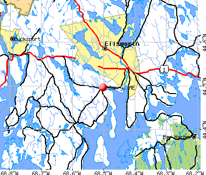
Surry, Maine
Submit your own pictures of this town and show them to the world
- OSM Map
- General Map
- Google Map
- MSN Map
Population change since 2000: +7.7%
 |
| Males: 729 | |
| Females: 737 |
| Median resident age: | 49.0 years |
| Maine median age: | 43.0 years |
Zip codes: 04684.
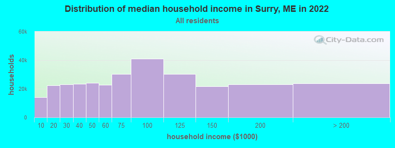
| Surry: | $67,409 |
| ME: | $69,543 |
Estimated per capita income in 2022: $38,982 (it was $19,199 in 2000)
Surry town income, earnings, and wages data
Estimated median house or condo value in 2022: $291,541 (it was $101,800 in 2000)
| Surry: | $291,541 |
| ME: | $290,600 |
Mean prices in 2022: all housing units: $379,336; detached houses: $396,802; townhouses or other attached units: $600,716; in 2-unit structures: $274,479; in 3-to-4-unit structures: $212,346; in 5-or-more-unit structures: $146,369; mobile homes: $158,183; occupied boats, rvs, vans, etc.: $16,454
Detailed information about poverty and poor residents in Surry, ME
Compare current foreclosures near Surry, ME:
| Photo | Address | Area | Beds / Baths | Price | Details |
|---|---|---|---|---|---|

|
#1
Surry Rd
Orland, ME 04472
|
- sq. feet
|
4 baths 5 beds |
$157,900
|
show details |

|
#2
Hinks St
Bucksport, ME 04416
|
1,320 sq. feet
|
1 baths 4 beds |
show details | |

|
#3
W Franklin Rd
Franklin, ME 04634
|
1,750 sq. feet
|
1 baths 3 beds |
show details | |

|
#4
Central St
Bucksport, ME 04416
|
- sq. feet
|
- baths - beds |
$63,000
|
show details |

|
#5
Front Ridge Rd
Penobscot, ME 04476
|
- sq. feet
|
- baths - beds |
show details | |

|
#6
Earles Way
Hancock, ME 04640
|
- sq. feet
|
- baths - beds |
show details | |

|
#7
Gott Brook Hts
Orland, ME 04472
|
- sq. feet
|
- baths - beds |
show details | |

|
#8
Central St
Bucksport, ME 04416
|
- sq. feet
|
- baths - beds |
show details | |

|
#9
Railroad Ln
Holden, ME 04429
|
- sq. feet
|
- baths - beds |
show details | |

|
Check over 1 million property listings on Foreclosure.com!
|
browse all offers | |||

- 1,41796.7%White alone
- 161.1%Two or more races
- 110.8%Asian alone
- 100.7%Hispanic
- 70.5%American Indian alone
- 30.2%Black alone
- 20.1%Other race alone

Races in Surry detailed stats: ancestries, foreign born residents, place of birth
According to our research of Maine and other state lists, there were 2 registered sex offenders living in Surry, Maine as of May 28, 2024.
The ratio of all residents to sex offenders in Surry is 733 to 1.
The ratio of registered sex offenders to all residents in this city is lower than the state average.
 Recent articles from our blog. Our writers, many of them Ph.D. graduates or candidates, create easy-to-read articles on a wide variety of topics.

 | Vacationing in Maine (17 replies) |
| What are you doing? (74 replies) |
| "The 18 Essential Maine Restaurants" (13 replies) |
| Blue Hill Peninsula- talk to me (12 replies) |
| Considering moving to Maine (10 replies) |
| Moving in my RV to Maine to search for a house in Bangor ME area, advice as to finding a homestead (21 replies) |
Latest news from Surry, ME collected exclusively by city-data.com from local newspapers, TV, and radio stations
Ancestries: English (21.7%), Irish (15.1%), United States (11.2%), German (9.6%), French (8.0%), Scottish (5.2%).
Current Local Time: EST time zone
Incorporated on 06/21/1803
Elevation: 118 feet
Land area: 37.2 square miles.
Population density: 39 people per square mile (very low).
38 residents are foreign born (1.1% Europe, 0.7% North America, 0.6% Asia).
| This town: | 2.8% |
| Maine: | 2.9% |
| Surry town: | 0.9% ($957) |
| Maine: | 1.5% ($1,417) |
Nearest city with pop. 50,000+: Portland, ME  (104.4 miles , pop. 64,249).
Nearest city with pop. 200,000+: Boston, MA (198.3 miles , pop. 589,141).
Nearest city with pop. 1,000,000+: Bronx, NY (371.3 miles , pop. 1,332,650).
Nearest cities:
), ), )Latitude: 44.49 N, Longitude: 68.51 W
Area code commonly used in this area: 207
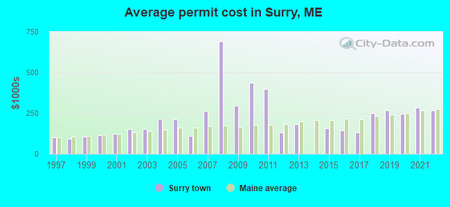
Single-family new house construction building permits:
- 2022: 7 buildings, average cost: $267,600
- 2021: 13 buildings, average cost: $282,600
- 2020: 11 buildings, average cost: $246,900
- 2019: 5 buildings, average cost: $269,300
- 2018: 4 buildings, average cost: $249,400
- 2017: 13 buildings, average cost: $131,700
- 2016: 12 buildings, average cost: $143,800
- 2015: 5 buildings, average cost: $157,000
- 2013: 4 buildings, average cost: $183,800
- 2012: 5 buildings, average cost: $130,000
- 2011: 1 building, cost: $400,000
- 2010: 5 buildings, average cost: $438,200
- 2009: 8 buildings, average cost: $298,400
- 2008: 7 buildings, average cost: $689,300
- 2007: 15 buildings, average cost: $261,600
- 2006: 36 buildings, average cost: $110,600
- 2005: 26 buildings, average cost: $211,800
- 2004: 13 buildings, average cost: $213,500
- 2003: 25 buildings, average cost: $152,500
- 2002: 23 buildings, average cost: $152,600
- 2001: 15 buildings, average cost: $121,000
- 2000: 21 buildings, average cost: $115,500
- 1999: 16 buildings, average cost: $105,400
- 1998: 21 buildings, average cost: $93,000
- 1997: 11 buildings, average cost: $99,900

| Here: | 2.6% |
| Maine: | 3.4% |

- Health care (14.6%)
- Construction (12.2%)
- Educational services (10.3%)
- Finance & insurance (5.8%)
- Professional, scientific, technical services (5.0%)
- Public administration (5.0%)
- Accommodation & food services (4.8%)
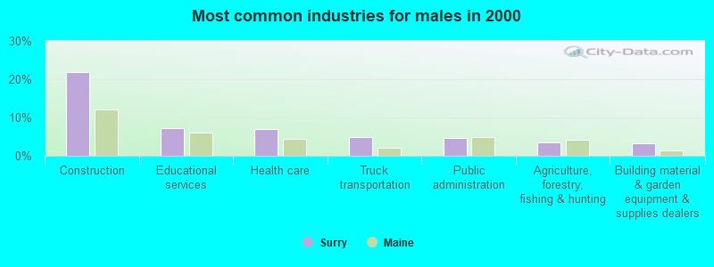
- Construction (21.8%)
- Educational services (7.2%)
- Health care (6.9%)
- Truck transportation (4.9%)
- Public administration (4.6%)
- Agriculture, forestry, fishing & hunting (3.4%)
- Building material & garden equipment & supplies dealers (3.2%)
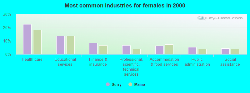
- Health care (22.5%)
- Educational services (13.6%)
- Finance & insurance (8.6%)
- Professional, scientific, technical services (6.8%)
- Accommodation & food services (6.5%)
- Public administration (5.3%)
- Social assistance (4.4%)
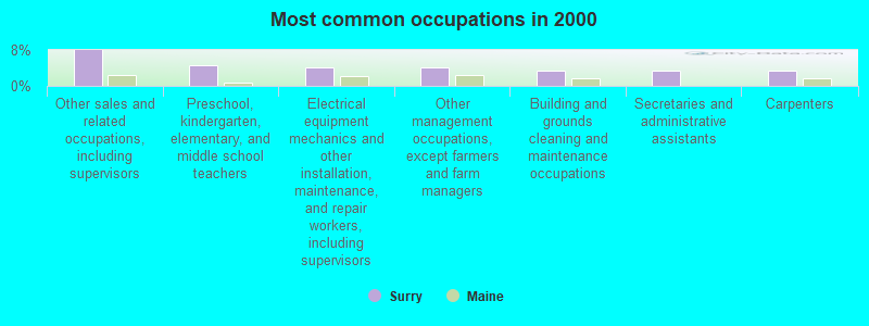
- Other sales and related occupations, including supervisors (8.0%)
- Preschool, kindergarten, elementary, and middle school teachers (4.7%)
- Electrical equipment mechanics and other installation, maintenance, and repair workers, including supervisors (4.2%)
- Other management occupations, except farmers and farm managers (4.1%)
- Building and grounds cleaning and maintenance occupations (3.5%)
- Secretaries and administrative assistants (3.5%)
- Carpenters (3.4%)
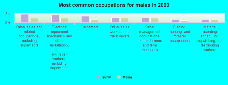
- Other sales and related occupations, including supervisors (8.9%)
- Electrical equipment mechanics and other installation, maintenance, and repair workers, including supervisors (8.3%)
- Carpenters (6.6%)
- Driver/sales workers and truck drivers (5.2%)
- Other management occupations, except farmers and farm managers (4.9%)
- Fishing, hunting, and forestry occupations (3.4%)
- Material recording, scheduling, dispatching, and distributing workers (3.4%)
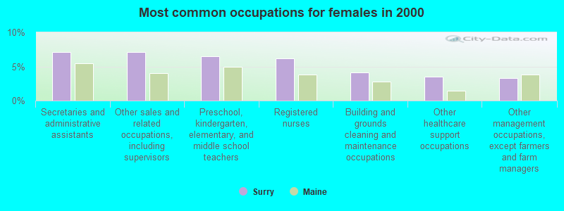
- Secretaries and administrative assistants (7.1%)
- Other sales and related occupations, including supervisors (7.1%)
- Preschool, kindergarten, elementary, and middle school teachers (6.5%)
- Registered nurses (6.2%)
- Building and grounds cleaning and maintenance occupations (4.1%)
- Other healthcare support occupations (3.6%)
- Other management occupations, except farmers and farm managers (3.3%)
Average climate in Surry, Maine
Based on data reported by over 4,000 weather stations


(lower is better)

Air Quality Index (AQI) level in 2023 was 61.9. This is about average.
| City: | 61.9 |
| U.S.: | 72.6 |
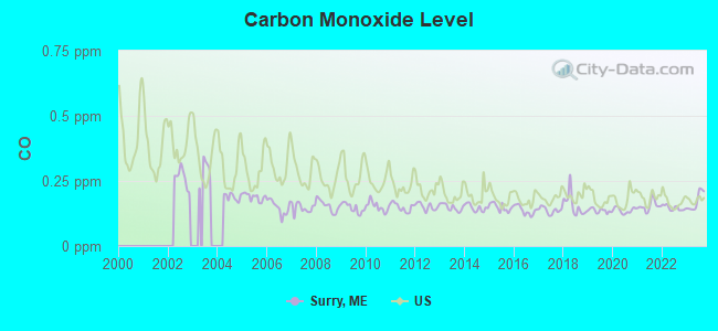
Carbon Monoxide (CO) [ppm] level in 2023 was 0.172. This is significantly better than average. Closest monitor was 11.8 miles away from the city center.
| City: | 0.172 |
| U.S.: | 0.251 |

Sulfur Dioxide (SO2) [ppb] level in 2023 was 0.0636. This is significantly better than average. Closest monitor was 11.8 miles away from the city center.
| City: | 0.0636 |
| U.S.: | 1.5147 |

Ozone [ppb] level in 2023 was 36.2. This is about average. Closest monitor was 11.8 miles away from the city center.
| City: | 36.2 |
| U.S.: | 33.3 |

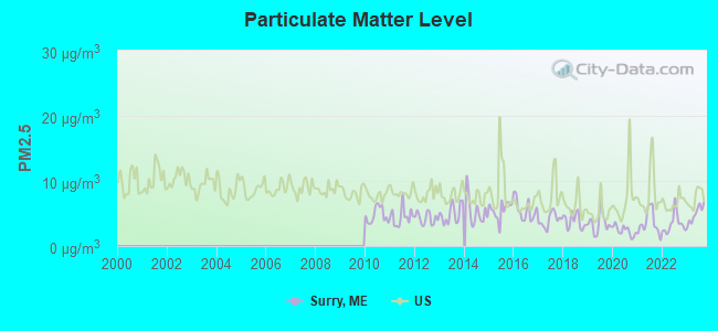
Particulate Matter (PM2.5) [µg/m3] level in 2023 was 4.90. This is significantly better than average. Closest monitor was 14.9 miles away from the city center.
| City: | 4.90 |
| U.S.: | 8.11 |
Earthquake activity:
Surry-area historical earthquake activity is significantly above Maine state average. It is 80% smaller than the overall U.S. average.On 10/16/2012 at 23:12:25, a magnitude 4.7 (4.7 ML, Depth: 10.0 mi, Class: Light, Intensity: IV - V) earthquake occurred 123.3 miles away from the city center
On 4/20/2002 at 10:50:47, a magnitude 5.3 (5.3 ML, Depth: 3.0 mi, Class: Moderate, Intensity: VI - VII) earthquake occurred 255.7 miles away from the city center
On 4/20/2002 at 10:50:47, a magnitude 5.2 (5.2 MB, 4.2 MS, 5.2 MW, 5.0 MW) earthquake occurred 256.8 miles away from the city center
On 1/19/1982 at 00:14:42, a magnitude 4.7 (4.5 MB, 4.7 MD, 4.5 LG) earthquake occurred 168.3 miles away from the city center
On 10/7/1983 at 10:18:46, a magnitude 5.3 (5.1 MB, 5.3 LG, 5.1 ML) earthquake occurred 291.3 miles away from Surry center
On 10/3/2006 at 00:07:38, a magnitude 3.7 (3.7 MD, Depth: 6.2 mi, Class: Light, Intensity: II - III) earthquake occurred 20.1 miles away from Surry center
Magnitude types: regional Lg-wave magnitude (LG), body-wave magnitude (MB), duration magnitude (MD), local magnitude (ML), surface-wave magnitude (MS), moment magnitude (MW)
Natural disasters:
The number of natural disasters in Hancock County (18) is near the US average (15).Major Disasters (Presidential) Declared: 11
Emergencies Declared: 6
Causes of natural disasters: Floods: 9, Storms: 8, Snows: 5, Blizzard: 1, Heavy Rain: 1, Hurricane: 1, Ice Storm: 1, Landslide: 1, Snowfall: 1, Wind: 1, Winter Storm: 1, Other: 2 (Note: some incidents may be assigned to more than one category).

Hospitals and medical centers near Surry:
- COURTLAND REHAB AND LIVING CENTER (Nursing Home, about 6 miles away; ELLSWORTH, ME)
- COLLIER'S REHAB AND NURSING CTR (Nursing Home, about 6 miles away; ELLSWORTH, ME)
- BIRCHWOOD LIVING CENTER (Hospital, about 7 miles away; ELLSWORTH, ME)
- SONOGEE ESTATES (Nursing Home, about 16 miles away; BAR HARBOR, ME)
- SONOGEE REHABILITATION AND LIVING CENTER (Nursing Home, about 16 miles away; BAR HARBOR, ME)
Colleges/universities with over 2000 students nearest to Surry:
- Husson University (about 27 miles; Bangor, ME; Full-time enrollment: 2,421)
- University of Maine (about 29 miles; Orono, ME; FT enrollment: 8,931)
- University of Maine at Augusta (about 65 miles; Augusta, ME; FT enrollment: 3,204)
- University of Maine at Farmington (about 82 miles; Farmington, ME; FT enrollment: 2,036)
- Southern Maine Community College (about 104 miles; South Portland, ME; FT enrollment: 4,666)
- University of Southern Maine (about 105 miles; Portland, ME; FT enrollment: 6,647)
- Saint Joseph's College of Maine (about 109 miles; Standish, ME; FT enrollment: 2,010)
Public elementary/middle school in Surry:
- SURRY ELEMENTARY SCHOOL (Location: 754 N BEND ROAD, Grades: KG-8)
Points of interest:
Notable locations in Surry: The Gatherings Campground (A), Surry Volunteer Fire Department (B). Display/hide their locations on the map
Church in Surry: Surry United Methodist Church (A). Display/hide its location on the map
Cemeteries: Cunningham Ridge Cemetery (1), South Surry Cemetery (2), Bayview Cemetery (3), Village Cemetery (4), West Surry Cemetery (5), Haskell Cemetery (6), Morgan Bay Cemetery (7). Display/hide their locations on the map
Lakes, reservoirs, and swamps: Toddy Pond (A), Gold Stream Pond (B), Beech Island Pond (C), Lower Patten Pond (D), Carlisle Meadow (E), The Heath (F), Floods Meadow (G), Mann Meadow (H). Display/hide their locations on the map
Streams, rivers, and creeks: Smelt Brook (A), Union River (B), Patten Stream (C), Emerton Brook (D), Meadow Brook (E), Flood Stream (F), Meadow Stream (G), Sandy Brook (H). Display/hide their locations on the map
Drinking water stations with addresses in Surry and their reported violations in the past:
SURRY INN (Population served: 160, Groundwater):Past monitoring violations:
- 2 routine major monitoring violations
| This town: | 2.2 people |
| Maine: | 2.3 people |
| This town: | 63.7% |
| Whole state: | 62.9% |
| This town: | 8.9% |
| Whole state: | 9.4% |
Likely homosexual households (counted as self-reported same-sex unmarried-partner households)
- Lesbian couples: 0.1% of all households
- Gay men: 0.9% of all households
| This town: | 14.6% |
| Whole state: | 10.9% |
| This town: | 7.1% |
| Whole state: | 4.1% |
For population 15 years and over in Surry:
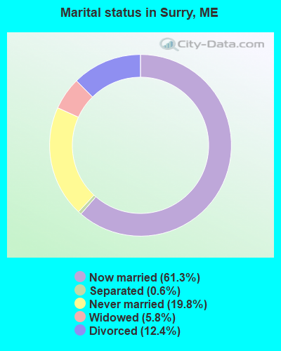
- Never married: 19.8%
- Now married: 61.3%
- Separated: 0.6%
- Widowed: 5.8%
- Divorced: 12.4%
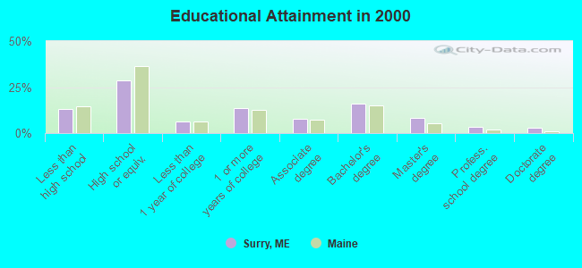
For population 25 years and over in Surry:
- High school or higher: 87.1%
- Bachelor's degree or higher: 30.7%
- Graduate or professional degree: 14.6%
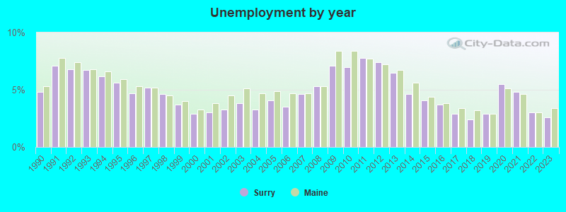
- Unemployed: 4.1%
- Mean travel time to work (commute): 24.9 minutes
| Here: | 11.7 |
| Maine average: | 11.2 |


Graphs represent county-level data. Detailed 2008 Election Results
Religion statistics for Surry, ME (based on Hancock County data)


| Religion | Adherents | Congregations |
|---|---|---|
| Mainline Protestant | 4,691 | 58 |
| Catholic | 2,523 | 9 |
| Evangelical Protestant | 1,288 | 23 |
| Other | 820 | 11 |
| None | 45,096 | - |
Food Environment Statistics:
| Here: | 6.01 / 10,000 pop. |
| State: | 2.80 / 10,000 pop. |
| Hancock County: | 1.69 / 10,000 pop. |
| Maine: | 2.20 / 10,000 pop. |
| Hancock County: | 4.89 / 10,000 pop. |
| Maine: | 5.75 / 10,000 pop. |
| Hancock County: | 21.61 / 10,000 pop. |
| State: | 11.02 / 10,000 pop. |
| Here: | 7.4% |
| Maine: | 8.2% |
| This county: | 25.4% |
| Maine: | 25.0% |
Businesses in Surry, ME
- U-Haul: 1
Strongest AM radio stations in Surry:
- WDEA (1370 AM; 5 kW; ELLSWORTH, ME; Owner: CUMULUS LICENSING CORP.)
- WZON (620 AM; 5 kW; BANGOR, ME; Owner: THE ZONE CORPORATION)
- WABI (910 AM; 5 kW; BANGOR, ME; Owner: CLEAR CHANNEL BROADCASTING LICENSES, INC.)
- WSKW (1160 AM; 10 kW; SKOWHEGAN, ME; Owner: MOUNTAIN WIRELESS, INCORPORATED)
- WRKO (680 AM; 50 kW; BOSTON, MA; Owner: ENTERCOM BOSTON LICENSE, LLC)
- WEEI (850 AM; 50 kW; BOSTON, MA; Owner: ENTERCOM BOSTON LICENSE, LLC)
- WBZ (1030 AM; 50 kW; BOSTON, MA; Owner: INFINITY BROADCASTING OPERATIONS, INC.)
- WTME (780 AM; 10 kW; RUMFORD, ME; Owner: MOUNTAIN VALLEY BROADCASTING, INC.)
- WNZS (1340 AM; 1 kW; VEAZIE, ME; Owner: WATERFRONT COMMUNICATIONS INC.)
- WCRN (830 AM; 50 kW; WORCESTER, MA; Owner: CARTER BROADCASTING CORPORATION)
- WNNZ (640 AM; 50 kW; WESTFIELD, MA; Owner: CLEAR CHANNEL BROADCASTING LICENSES, INC.)
- WKOX (1200 AM; 50 kW; FRAMINGHAM, MA; Owner: CAPSTAR TX LIMITED PARTNERSHIP)
- WALE (990 AM; 50 kW; GREENVILLE, RI; Owner: NORTH AMERICAN BROADCASTING CO., INC.)
Strongest FM radio stations in Surry:
- WERU-FM (89.9 FM; BLUE HILL, ME; Owner: SALT POND COMMUNITY B/C COMPANY)
- WWMJ (95.7 FM; ELLSWORTH, ME; Owner: CUMULUS LICENSING CORP.)
- WLKE (99.1 FM; BAR HARBOR, ME; Owner: CLEAR CHANNEL BROADCASTING LICENSES, INC.)
- WBFB (104.7 FM; BELFAST, ME; Owner: CLEAR CHANNEL BROADCASTING LICENSES, INC.)
- WFZX (101.7 FM; SEARSPORT, ME; Owner: CLEAR CHANNEL BROADCASTING LICENSES, INC.)
- WKIT-FM (100.3 FM; BREWER, ME; Owner: THE ZONE CORPORATION)
- WMEH (90.9 FM; BANGOR, ME; Owner: MAINE PUBLIC BROADCASTING CORPORATION)
- WNSX (97.7 FM; WINTER HARBOR, ME; Owner: CLEAR CHANNEL BROADCASTING LICENSES, INC.)
- WEZQ (92.9 FM; BANGOR, ME; Owner: CUMULUS LICENSING CORP.)
- WWBX (97.1 FM; BANGOR, ME; Owner: CLEAR CHANNEL BROADCASTING LICENSES, INC.)
- WHCF (88.5 FM; BANGOR, ME; Owner: BANGOR BAPTIST CHURCH)
- WMEP (90.5 FM; CAMDEN, ME; Owner: MAINE PUBLIC BROADCASTING CORP.)
- WQSS (102.5 FM; CAMDEN, ME; Owner: CLEAR CHANNEL BROADCASTING LICENSES, INC.)
- WBQI (107.7 FM; BAR HARBOR, ME; Owner: MARINER BROADCASTING, L.P.)
- WVOM (103.9 FM; HOWLAND, ME; Owner: CLEAR CHANNEL BROADCASTING LICENSES, INC.)
TV broadcast stations around Surry:
- WMEB-TV (Channel 12; ORONO, ME; Owner: MAINE PUBLIC BROADCASTING CORPORATION)
- WCKD-LP (Channel 30; BANGOR/DEDHAM, ME; Owner: J. MCLEOD, ME FAMILY B/CING., INC.)
- WLBZ (Channel 2; BANGOR, ME; Owner: PACIFIC AND SOUTHERN COMPANY, INC.)
- WABI-TV (Channel 5; BANGOR, ME; Owner: COMMUNITY BROADCASTING SERVICE)
- WBGR-LP (Channel 33; BANGOR/DEDHAM, ME; Owner: MAINE FAMILY BROADCASTING, INC.)
- W66CL (Channel 66; BANGOR, ME; Owner: MS COMMUNICATIONS, LLC)
- Surry, Maine
- Fatal accident count16
- Vehicles involved in fatal accidents22
- Fatal accidents involving drunk persons:7
- Fatalities16
- Persons involved in fatal accidents30
- Pedestrians involved in fatal accidents1
- Maine average
- Fatal accident count2208
- Vehicles involved in fatal accidents3106
- Fatal accidents involving drunk persons849
- Fatalities2449
- Persons involved in fatal accidents5067
- Pedestrians involved in fatal accidents179
- National Bridge Inventory (NBI) Statistics
- 2Number of bridges
- 7ft / 2.4mTotal length
- 1,734Total average daily traffic
- 86Total average daily truck traffic
- 2,775Total future (year 2036) average daily traffic
FCC Registered Antenna Towers:
10 (See the full list of FCC Registered Antenna Towers in Surry)FCC Registered Microwave Towers:
1- SURRY, State Highway 172 (Lat: 44.494500 Lon: -68.454444), Overall height: 24.4 m, Call Sign: KTQ61, Licensee ID: L00002046,
Assigned Frequencies: 2112.00 MHz, Grant Date: 07/25/1991, Expiration Date: 02/01/2001, Cancellation Date: 12/10/1997, Registrant: Contel Of Maine Inc, 85 Sheep Davis Rd, Concord, NH 03301
FCC Registered Amateur Radio Licenses:
18 (See the full list of FCC Registered Amateur Radio Licenses in Surry)FAA Registered Aircraft:
2- Aircraft: CESSNA 172G (Category: Land, Seats: 4, Weight: Up to 12,499 Pounds, Speed: 105 mph), Engine: CONT MOTOR 0-300 SER (145 HP) (Reciprocating)
N-Number: 3829L, N3829L, N-3829L, Serial Number: 17253998, Year manufactured: 1965, Certificate Issue Date: 07/20/1994
Registrant (Individual): Daniel A Mcgraw, 529 Morgan Bay Rd, Surry, ME 04684 - Aircraft: PIPER PA-28-140 (Category: Land, Seats: 4, Weight: Up to 12,499 Pounds, Speed: 107 mph), Engine: LYCOMING 0-320 SERIES (180 HP) (Reciprocating)
N-Number: 8870N, N8870N, N-8870N, Serial Number: 28-25732, Year manufactured: 1969, Airworthiness Date: 03/28/1969, Certificate Issue Date: 01/28/2003
Registrant (Co-Owned): Daniel C Herrick, 162 Cross Rd, Surry, ME 04684, Other Owners: Dennis M Riley
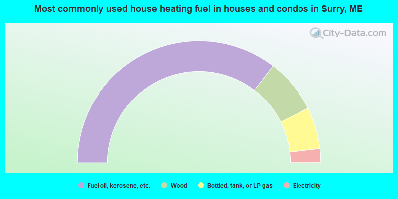
- 70.8%Fuel oil, kerosene, etc.
- 14.5%Wood
- 11.0%Bottled, tank, or LP gas
- 3.7%Electricity
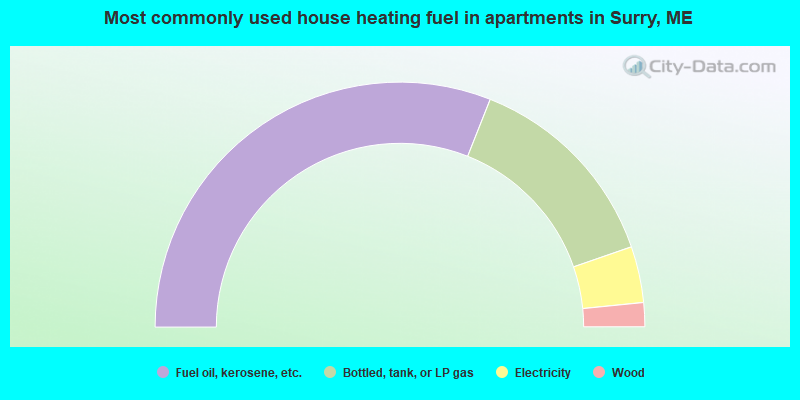
- 62.1%Fuel oil, kerosene, etc.
- 27.4%Bottled, tank, or LP gas
- 7.4%Electricity
- 3.2%Wood
Surry compared to Maine state average:
- Unemployed percentage significantly below state average.
- Black race population percentage significantly below state average.
- Hispanic race population percentage below state average.
- Median age above state average.
- Renting percentage below state average.
- Length of stay since moving in significantly above state average.
- Number of rooms per house significantly below state average.
- House age significantly below state average.

|
Total of 14 patent applications in 2008-2024.