Surrency-Thornton, Georgia
Submit your own pictures of this place and show them to the world
- OSM Map
- Google Map
- MSN Map
| Males: 796 | |
| Females: 823 |
| Median resident age: | 39.9 years |
| Georgia median age: | 33.4 years |
Zip code: 31563
| Surrency-Thornton: | $44,543 |
| GA: | $72,837 |
Estimated per capita income in 2022: $24,391 (it was $15,111 in 2000)
Surrency-Thornton CCD income, earnings, and wages data
Estimated median house or condo value in 2022: $125,396 (it was $60,100 in 2000)
| Surrency-Thornton: | $125,396 |
| GA: | $297,400 |
Mean prices in 2022: all housing units: $145,540; detached houses: $168,749; townhouses or other attached units: $199,563; mobile homes: $91,533
Surrency-Thornton, GA residents, houses, and apartments details
Detailed information about poverty and poor residents in Surrency-Thornton, GA


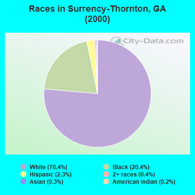
- 1,20376.4%White alone
- 32120.4%Black alone
- 372.3%Hispanic
- 70.4%Two or more races
- 40.3%Asian alone
- 30.2%American Indian alone
Races in Surrency-Thornton detailed stats: ancestries, foreign born residents, place of birth
 Recent articles from our blog. Our writers, many of them Ph.D. graduates or candidates, create easy-to-read articles on a wide variety of topics.
Current Local Time: EST time zone
Land area: 150.6 square miles.
Population density: 11 people per square mile (very low).
| Surrency-Thornton CCD: | 0.6% ($365) |
| Georgia: | 0.9% ($919) |
Nearest city with pop. 50,000+: Savannah, GA  (70.5 miles , pop. 131,510).
Nearest city with pop. 200,000+: Jacksonville, FL (97.0 miles , pop. 735,617).
Nearest city with pop. 1,000,000+: Philadelphia, PA (700.0 miles , pop. 1,517,550).
Nearest cities:
), ), ), )Latitude: 31.64 N, Longitude: 82.20 W
Area code commonly used in this area: 912

| Here: | 3.0% |
| Georgia: | 2.9% |

- Agriculture, forestry, fishing & hunting (15.1%)
- Educational services (12.5%)
- Public administration (6.7%)
- Construction (6.5%)
- Truck transportation (5.0%)
- Wood products (4.6%)
- Repair & maintenance (4.3%)

- Agriculture, forestry, fishing & hunting (23.2%)
- Construction (10.0%)
- Wood products (8.5%)
- Truck transportation (7.5%)
- Repair & maintenance (6.6%)
- Paper (4.7%)
- Utilities (4.1%)

- Educational services (26.0%)
- Public administration (11.7%)
- Textile mills & textile products (6.8%)
- Health care (6.8%)
- Social assistance (5.7%)
- Agriculture, forestry, fishing & hunting (5.3%)
- Accommodation & food services (4.2%)

- Secretaries and administrative assistants (6.7%)
- Other production occupations, including supervisors (6.2%)
- Preschool, kindergarten, elementary, and middle school teachers (6.0%)
- Driver/sales workers and truck drivers (5.8%)
- Agricultural workers, including supervisors (5.0%)
- Electrical equipment mechanics and other installation, maintenance, and repair workers, including supervisors (4.6%)
- Farmers and farm managers (4.5%)

- Driver/sales workers and truck drivers (10.7%)
- Agricultural workers, including supervisors (8.5%)
- Electrical equipment mechanics and other installation, maintenance, and repair workers, including supervisors (8.5%)
- Other production occupations, including supervisors (8.5%)
- Farmers and farm managers (8.2%)
- Fishing, hunting, and forestry occupations (6.0%)
- Drafters, engineering, and mapping technicians (5.0%)

- Secretaries and administrative assistants (14.7%)
- Preschool, kindergarten, elementary, and middle school teachers (13.2%)
- Other teachers, instructors, education, training, and library occupations (7.5%)
- Building and grounds cleaning and maintenance occupations (6.0%)
- Textile, apparel, and furnishings workers (5.7%)
- Other office and administrative support workers, including supervisors (4.9%)
- Registered nurses (3.8%)
Average climate in Surrency-Thornton, Georgia
Based on data reported by over 4,000 weather stations


Tornado activity:
Surrency-Thornton-area historical tornado activity is below Georgia state average. It is 19% smaller than the overall U.S. average.
On 5/11/2008, a category F4 (max. wind speeds 207-260 mph) tornado 46.7 miles away from the Surrency-Thornton place center injured 9 people and caused $13 million in damages.
On 11/18/1968, a category F3 (max. wind speeds 158-206 mph) tornado 33.1 miles away from the place center caused between $5000 and $50,000 in damages.
Earthquake activity:
Surrency-Thornton-area historical earthquake activity is significantly above Georgia state average. It is 41% smaller than the overall U.S. average.On 8/2/1974 at 08:52:09, a magnitude 4.9 (4.3 MB, 4.9 LG, Class: Light, Intensity: IV - V) earthquake occurred 155.2 miles away from Surrency-Thornton center
On 11/22/1974 at 05:25:55, a magnitude 4.7 (4.7 MB) earthquake occurred 148.5 miles away from Surrency-Thornton center
On 8/21/1992 at 16:31:55, a magnitude 4.4 (4.1 MB, 4.1 LG, 4.4 LG, Depth: 6.2 mi) earthquake occurred 156.1 miles away from Surrency-Thornton center
On 4/29/2003 at 08:59:39, a magnitude 4.9 (4.4 MB, 4.6 MW, 4.9 LG) earthquake occurred 279.9 miles away from Surrency-Thornton center
On 7/13/2003 at 20:15:16, a magnitude 3.6 (3.6 MB, Depth: 3.1 mi, Class: Light, Intensity: II - III) earthquake occurred 48.1 miles away from Surrency-Thornton center
On 2/15/2014 at 03:23:38, a magnitude 4.1 (4.1 MW, Depth: 3.2 mi) earthquake occurred 150.6 miles away from the city center
Magnitude types: regional Lg-wave magnitude (LG), body-wave magnitude (MB), moment magnitude (MW)
Natural disasters:
The number of natural disasters in Appling County (11) is smaller than the US average (15).Major Disasters (Presidential) Declared: 5
Emergencies Declared: 4
Causes of natural disasters: Storms: 4, Floods: 3, Hurricanes: 3, Tornadoes: 3, Winds: 2, Drought: 1, Snowfall: 1, Tropical Storm: 1, Winter Storm: 1, Other: 1 (Note: some incidents may be assigned to more than one category).
Hospitals and medical centers near Surrency-Thornton:
- BAXLEY DIALYSIS (Dialysis Facility, about 13 miles away; BAXLEY, GA)
- ALTAMAHA HOMECARE, INC (Home Health Center, about 13 miles away; BAXLEY, GA)
- APPLING HOSPITAL Acute Care Hospitals (about 13 miles away; BAXLEY, GA)
- APPLING NURSING AND REHABILITATION PAVILION (Nursing Home, about 13 miles away; BAXLEY, GA)
Operable nuclear power plants near Surrency-Thornton:
- 13 miles: Edwin I. Hatch 1 and 2 in Baxley, GA.
Colleges/universities with over 2000 students nearest to Surrency-Thornton:
- South Georgia State College (about 40 miles; Douglas, GA; Full-time enrollment: 2,507)
- College of Coastal Georgia (about 55 miles; Brunswick, GA; FT enrollment: 2,447)
- Georgia Southern University (about 60 miles; Statesboro, GA; FT enrollment: 18,824)
- Armstrong Atlantic State University (about 66 miles; Savannah, GA; FT enrollment: 6,399)
- East Georgia State College (about 67 miles; Swainsboro, GA; FT enrollment: 2,345)
- South University–Savannah Online (about 70 miles; Savannah, GA; FT enrollment: 13,512)
- Savannah Technical College (about 70 miles; Savannah, GA; FT enrollment: 3,677)
Points of interest:
Notable locations in Surrency-Thornton: Appling County Fire Department 4th District Station (A), Appling County Fire Department County Line Station (B), Surrency Volunteer Fire Department (C), Long Branch Community Center (D). Display/hide their locations on the map
Churches in Surrency-Thornton include: Antioch Church (A), Pine Ridge Church (B), Second Pleasant Hill Baptist Church (C), Surrency Evangelistic Church (D), Surrency Grove Church (E), Surrency Missionary Baptist Church (F), Surrency United Methodist Church (G), Surrency Grove Baptist Church (H), Jesus Church (I). Display/hide their locations on the map
Cemeteries: Milikin Cemetery (1), Surrency Cemetery (2), Davis Cemetery (3), Dixon Cemetery (4), Overstreet Cemetery (5), Patterson Cemetery (6), Griffis Cemetery (7). Display/hide their locations on the map
Streams, rivers, and creeks: Sweetwater Creek (A), Dry Branch (B), Alisons Creek (C). Display/hide their locations on the map
| This place: | 2.5 people |
| Georgia: | 2.6 people |
| This place: | 57.5% |
| Whole state: | 70.7% |
| This place: | 2.7% |
| Whole state: | 4.8% |
Likely homosexual households (counted as self-reported same-sex unmarried-partner households)
- Lesbian couples: 0.2% of all households
- Gay men: 0.3% of all households
| This place: | 20.8% |
| Whole state: | 13.0% |
| This place: | 8.1% |
| Whole state: | 6.1% |
For population 15 years and over in Surrency-Thornton:

- Never married: 18.6%
- Now married: 58.3%
- Separated: 2.3%
- Widowed: 11.3%
- Divorced: 11.8%
For population 25 years and over in Surrency-Thornton:
- High school or higher: 65.4%
- Bachelor's degree or higher: 7.2%
- Graduate or professional degree: 3.1%
- Unemployed: 1.5%
- Mean travel time to work (commute): 31.0 minutes


| Here: | 12.2 |
| Georgia average: | 13.3 |
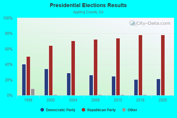
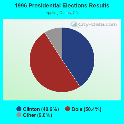
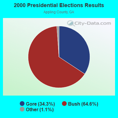
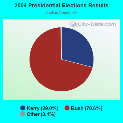
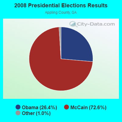
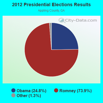

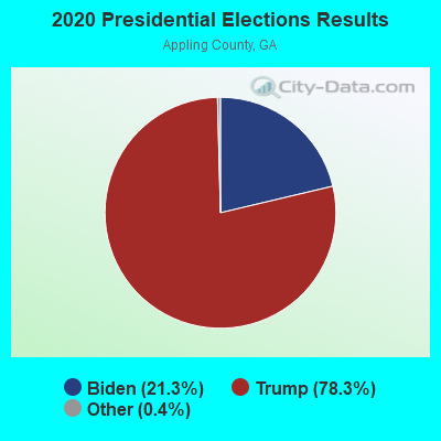
Graphs represent county-level data. Detailed 2008 Election Results
Religion statistics for Surrency-Thornton, GA (based on Appling County data)
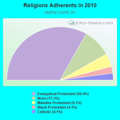
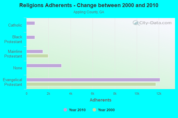
| Religion | Adherents | Congregations |
|---|---|---|
| Evangelical Protestant | 12,109 | 46 |
| Mainline Protestant | 1,472 | 10 |
| Black Protestant | 751 | 5 |
| Catholic | 742 | 1 |
| Other | 1 | 1 |
| None | 3,161 | - |
Food Environment Statistics:
| This county: | 1.12 / 10,000 pop. |
| State: | 1.91 / 10,000 pop. |
| This county: | 0.56 / 10,000 pop. |
| State: | 0.15 / 10,000 pop. |
| Appling County: | 1.12 / 10,000 pop. |
| Georgia: | 0.86 / 10,000 pop. |
| Appling County: | 7.26 / 10,000 pop. |
| Georgia: | 5.12 / 10,000 pop. |
| Appling County: | 8.38 / 10,000 pop. |
| Georgia: | 7.41 / 10,000 pop. |
| Appling County: | 10.9% |
| State: | 10.4% |
| Appling County: | 30.2% |
| Georgia: | 27.8% |
| This county: | 11.2% |
| State: | 14.6% |
Strongest AM radio stations in Surrency-Thornton:
- WUFE (1260 AM; daytime; 5 kW; BAXLEY, GA; Owner: SOUTH GEORGIA BROADCASTERS, INC.)
- WLOP (1370 AM; 5 kW; JESUP, GA; Owner: JESUP BROADCASTING CORP.)
- WOKV (690 AM; 50 kW; JACKSONVILLE, FL; Owner: COX RADIO, INC.)
- WFVR (910 AM; 50 kW; VALDOSTA, GA; Owner: RAMA COMMUNICATIONS, INC.)
- WDMG (860 AM; 5 kW; DOUGLAS, GA; Owner: RTG RADIO, LLC)
- WOBS (1530 AM; daytime; 50 kW; JACKSONVILLE, FL; Owner: WORD BROADCASTING NETWORK, INC.)
- WCGA (1100 AM; daytime; 10 kW; WOODBINE, GA; Owner: COX BROADCAST GROUP, INC.)
- WFNS (1350 AM; 2 kW; BLACKSHEAR, GA; Owner: MARMAC COMMUNICATIONS, LLC)
- WMAC (940 AM; 50 kW; MACON, GA; Owner: CUMULUS LICENSING CORP.)
- WGSR (1570 AM; 50 kW; FERNANDINA BEACH, FL; Owner: RJM COMMUNICATIONS, INC)
- WVOP (970 AM; 5 kW; VIDALIA, GA; Owner: VIDALIA COMMUNICATIONS CORPORATION)
- WAJQ (1400 AM; 1 kW; ALMA, GA; Owner: BLUEBERRY BROADCASTING COMPANY, INC.)
- WSTT (730 AM; 25 kW; THOMASVILLE, GA; Owner: MARION R. WILLIAMS)
Strongest FM radio stations in Surrency-Thornton:
- WBYZ (94.5 FM; BAXLEY, GA; Owner: SOUTH GEORGIA BROADCASTERS, INC.)
- WLPT (88.3 FM; JESUP, GA; Owner: AUGUSTA RADIO FELLOWSHIP INSTITUTE, INC.)
- WWSN (103.3 FM; WAYCROSS, GA; Owner: QANTUM OF BRUNSWICK LICENSE COMPANY, LLC)
- WAJQ-FM (104.3 FM; ALMA, GA; Owner: BLUEBERRY BROADCASTING COMPANY, INC.)
- WYNR (102.5 FM; WAYCROSS, GA; Owner: QANTUM OF BRUNSWICK LICENSE COMPANY, LLC)
- WXVS (90.1 FM; WAYCROSS, GA; Owner: GEORGIA PUBLIC TELECOMMUNICATIONS COMMISSION)
- WIFO-FM (105.5 FM; JESUP, GA; Owner: JESUP BROADCASTING CORP.)
- WOKA-FM (106.7 FM; DOUGLAS, GA; Owner: COFFEE COUNTY BROADCASTERS, INC.)
TV broadcast stations around Surrency-Thornton:
- WPXC-TV (Channel 21; BRUNSWICK, GA; Owner: PAXSON JAX LICENSE, INC.)
- WGSA (Channel 34; BAXLEY, GA; Owner: SOUTHERN TV CORPORATION)
- WXGA-TV (Channel 8; WAYCROSS, GA; Owner: GEORGIA PUBLIC TELECOMMUNICATIONS COMMISSION)
- W39BV (Channel 39; HINESVILLE-RICHMOND, GA; Owner: SOUTHERN TV CORPORATION)

- 52.3%Electricity
- 37.5%Bottled, tank, or LP gas
- 5.3%Wood
- 1.3%Utility gas
- 1.3%Fuel oil, kerosene, etc.
- 1.3%Other fuel
- 1.1%No fuel used

- 74.4%Bottled, tank, or LP gas
- 23.1%Electricity
- 2.6%Wood
Surrency-Thornton compared to Georgia state average:
- Median household income below state average.
- Median house value significantly below state average.
- Unemployed percentage significantly below state average.
- Hispanic race population percentage significantly below state average.
- Foreign-born population percentage significantly below state average.
- Renting percentage significantly below state average.
- Length of stay since moving in significantly above state average.
- Number of rooms per house significantly below state average.
- House age significantly below state average.
- Number of college students significantly below state average.
- Percentage of population with a bachelor's degree or higher significantly below state average.