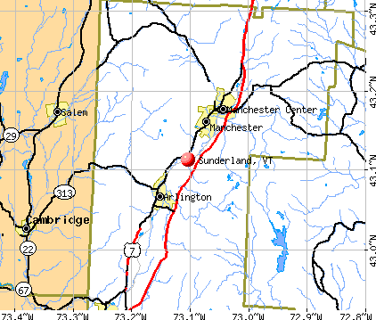
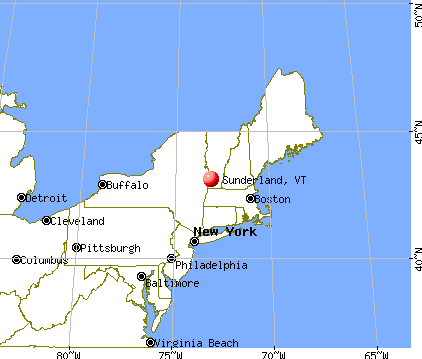
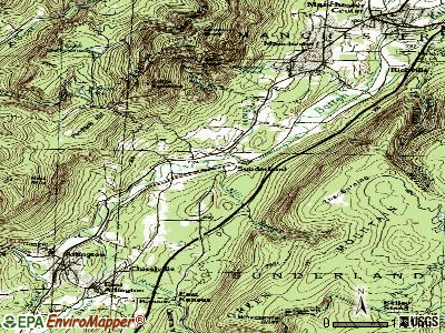
Sunderland, Vermont
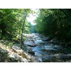
Sunderland: Spring Scene at Kelly Stand Road, Sunderland, Vermont
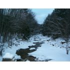
Sunderland: Winter Scene at Kelly Stand Road, Sunderland, Vermont
- add
your
Submit your own pictures of this town and show them to the world
- OSM Map
- General Map
- Google Map
- MSN Map
Population change since 2000: +12.5%
 |
| Males: 468 | |
| Females: 488 |
| Median resident age: | 45.3 years |
| Vermont median age: | 45.8 years |
Zip codes: 05252.
| Sunderland: | $69,522 |
| VT: | $73,991 |
Estimated per capita income in 2022: $36,956 (it was $19,453 in 2000)
Sunderland town income, earnings, and wages data
Estimated median house or condo value in 2022: $272,534 (it was $113,600 in 2000)
| Sunderland: | $272,534 |
| VT: | $304,700 |
Mean prices in 2022: all housing units: $328,619; detached houses: $344,818; townhouses or other attached units: $277,995; in 2-unit structures: $228,670; in 3-to-4-unit structures: $413,467; in 5-or-more-unit structures: $239,659; mobile homes: $88,728
Detailed information about poverty and poor residents in Sunderland, VT
Compare current foreclosures near Sunderland, VT:
| Photo | Address | Area | Beds / Baths | Price | Details |
|---|---|---|---|---|---|

|
#1
Historic Route-7a
Manchester, VT 05254
|
1,800 sq. feet
|
2 baths 2 beds |
$329,900
|
show details |

|
#2
Chapel Rd
Bennington, VT 05201
|
1,000 sq. feet
|
1 baths 2 beds |
$260,000
|
show details |

|
#3
Bates Rd
Cambridge, NY 12816
|
2,422 sq. feet
|
2 baths 3 beds |
show details | |

|
#4
Route 67
Hoosick Falls, NY 12090
|
- sq. feet
|
1 baths 2 beds |
show details | |

|
#5
State Route 313
Cambridge, NY 12816
|
2,965 sq. feet
|
3 baths 4 beds |
show details | |

|
#6
Briansky Ln
Salem, NY 12865
|
2,918 sq. feet
|
3 baths 3 beds |
show details | |

|
#7
Tinkham Rd
North Bennington, VT 05257
|
- sq. feet
|
- baths - beds |
show details | |

|
#8
Shaker Hollow Rd
Eagle Bridge, NY 12057
|
864 sq. feet
|
- baths - beds |
show details | |

|
#9
Jerome Dr
Cambridge, NY 12816
|
924 sq. feet
|
- baths - beds |
show details | |

|
#10
Main St Apt 2
Bennington, VT 05201
|
- sq. feet
|
- baths - beds |
show details |
| Photo | Address | Area | Beds / Baths | Price | Details |
|---|---|---|---|---|---|

|
#11
South St
Bennington, VT 05201
|
- sq. feet
|
- baths - beds |
show details | |

|
#12
Houghton Ln
Bennington, VT 05201
|
- sq. feet
|
- baths - beds |
show details | |

|
#13
Hillside St
Bennington, VT 05201
|
- sq. feet
|
- baths - beds |
show details | |

|
#14
Putnam St
Bennington, VT 05201
|
- sq. feet
|
- baths - beds |
show details | |

|
#15
Route 67
Hoosick Falls, NY 12090
|
- sq. feet
|
- baths - beds |
show details | |

|
#16
Vt Route 30
Pawlet, VT 05761
|
- sq. feet
|
- baths - beds |
show details | |

|
Check over 1 million property listings on Foreclosure.com!
|
browse all offers | |||

- 90995.1%White alone
- 232.4%Two or more races
- 192.0%Hispanic
- 30.3%Asian alone
- 20.2%Black alone

Races in Sunderland detailed stats: ancestries, foreign born residents, place of birth
According to our research of Vermont and other state lists, there was 1 registered sex offender living in Sunderland, Vermont as of May 29, 2024.
The ratio of all residents to sex offenders in Sunderland is 956 to 1.
The ratio of registered sex offenders to all residents in this city is lower than the state average.
 Recent articles from our blog. Our writers, many of them Ph.D. graduates or candidates, create easy-to-read articles on a wide variety of topics.

 | Taking job in Sunderland: relocation to Bennington area? (5 replies) |
| Driving to VT from LI this Fall (20 replies) |
| Amber Alert Missing Sunderland Boy (1 reply) |
| Vermont Weather (3779 replies) |
| High Schools in Vermont (23 replies) |
| Should I move from Maine to Manchester, VT? (27 replies) |
Latest news from Sunderland, VT collected exclusively by city-data.com from local newspapers, TV, and radio stations
Ancestries: Irish (27.9%), English (22.9%), French (18.0%), German (14.4%), United States (7.3%), Italian (6.9%).
Current Local Time: EST time zone
Elevation: 640 feet
Land area: 45.4 square miles.
Population density: 21 people per square mile (very low).
12 residents are foreign born
| This town: | 1.4% |
| Vermont: | 3.8% |
| Sunderland town: | 1.8% ($2,068) |
| Vermont: | 2.0% ($2,196) |
Nearest city with pop. 50,000+: Albany, NY  (45.3 miles , pop. 95,658).
Nearest city with pop. 200,000+: Boston, MA (114.6 miles , pop. 589,141).
Nearest city with pop. 1,000,000+: Bronx, NY (159.5 miles , pop. 1,332,650).
Nearest cities:
), Latitude: 43.08 N, Longitude: 73.10 W
Area code commonly used in this area: 802


Single-family new house construction building permits:
- 2022: 2 buildings, average cost: $225,000
- 2021: 3 buildings, average cost: $266,100
- 2020: 2 buildings, average cost: $248,200
- 2019: 1 building, cost: $249,800
- 2018: 3 buildings, average cost: $255,800
- 2017: 1 building, cost: $240,000
- 2016: 4 buildings, average cost: $260,600
- 2015: 5 buildings, average cost: $250,900
- 2014: 3 buildings, average cost: $211,000
- 2013: 1 building, cost: $300,000
- 2012: 4 buildings, average cost: $105,000
- 2011: 1 building, cost: $220,300
- 2010: 3 buildings, average cost: $233,300
- 2009: 5 buildings, average cost: $225,800
- 2008: 9 buildings, average cost: $182,400
- 2007: 14 buildings, average cost: $177,800
- 2006: 3 buildings, average cost: $194,900
- 2005: 6 buildings, average cost: $150,400
- 2004: 12 buildings, average cost: $163,900
- 2003: 10 buildings, average cost: $132,800
- 2002: 9 buildings, average cost: $130,700
- 2001: 6 buildings, average cost: $121,400
- 2000: 9 buildings, average cost: $118,000
- 1999: 4 buildings, average cost: $150,000
- 1998: 5 buildings, average cost: $87,400
- 1997: 4 buildings, average cost: $87,400


| Here: | 1.0% |
| Vermont: | 2.0% |


- Educational services (14.4%)
- Accommodation & food services (10.6%)
- Construction (7.1%)
- Health care (4.7%)
- Administrative & support & waste management services (4.5%)
- Professional, scientific, technical services (4.5%)
- Repair & maintenance (3.5%)

- Construction (13.2%)
- Educational services (7.4%)
- Electronic shopping & mail-order houses (6.4%)
- Repair & maintenance (5.9%)
- Administrative & support & waste management services (5.9%)
- Finance & insurance (4.4%)
- Professional, scientific, technical services (3.9%)

- Educational services (20.9%)
- Accommodation & food services (17.3%)
- Health care (7.7%)
- Professional, scientific, technical services (5.0%)
- Sporting goods, camera, hobby & toy stores (4.1%)
- Miscellaneous manufacturing (3.6%)
- Clothing & accessories, including shoe, stores (3.2%)

- Other sales and related occupations, including supervisors (9.4%)
- Other management occupations, except farmers and farm managers (5.4%)
- Preschool, kindergarten, elementary, and middle school teachers (5.2%)
- Building and grounds cleaning and maintenance occupations (4.7%)
- Other office and administrative support workers, including supervisors (4.2%)
- Secretaries and administrative assistants (3.8%)
- Retail sales workers, except cashiers (3.5%)

- Other sales and related occupations, including supervisors (7.8%)
- Other management occupations, except farmers and farm managers (7.4%)
- Driver/sales workers and truck drivers (6.9%)
- Vehicle and mobile equipment mechanics, installers, and repairers (5.4%)
- Carpenters (3.4%)
- Other office and administrative support workers, including supervisors (3.4%)
- Electrical equipment mechanics and other installation, maintenance, and repair workers, including supervisors (3.4%)

- Other sales and related occupations, including supervisors (10.9%)
- Preschool, kindergarten, elementary, and middle school teachers (9.1%)
- Secretaries and administrative assistants (7.3%)
- Building and grounds cleaning and maintenance occupations (6.8%)
- Cooks and food preparation workers (6.8%)
- Other teachers, instructors, education, training, and library occupations (5.0%)
- Other office and administrative support workers, including supervisors (5.0%)
Average climate in Sunderland, Vermont
Based on data reported by over 4,000 weather stations


(lower is better)

Air Quality Index (AQI) level in 2022 was 51.9. This is better than average.
| City: | 51.9 |
| U.S.: | 72.6 |

Ozone [ppb] level in 2022 was 29.1. This is about average. Closest monitor was 14.1 miles away from the city center.
| City: | 29.1 |
| U.S.: | 33.3 |

Particulate Matter (PM2.5) [µg/m3] level in 2022 was 5.56. This is significantly better than average. Closest monitor was 14.5 miles away from the city center.
| City: | 5.56 |
| U.S.: | 8.11 |
Tornado activity:
Sunderland-area historical tornado activity is significantly above Vermont state average. It is 46% smaller than the overall U.S. average.
On 5/31/1998, a category F3 (max. wind speeds 158-206 mph) tornado 11.2 miles away from the Sunderland town center injured 68 people and caused $71 million in damages.
On 8/20/1968, a category F3 tornado 15.0 miles away from the town center injured one person and caused between $5000 and $50,000 in damages.
Earthquake activity:
Sunderland-area historical earthquake activity is significantly above Vermont state average. It is 69% smaller than the overall U.S. average.On 10/7/1983 at 10:18:46, a magnitude 5.3 (5.1 MB, 5.3 LG, 5.1 ML, Class: Moderate, Intensity: VI - VII) earthquake occurred 87.0 miles away from Sunderland center
On 4/20/2002 at 10:50:47, a magnitude 5.3 (5.3 ML, Depth: 3.0 mi) earthquake occurred 103.6 miles away from the city center
On 4/20/2002 at 10:50:47, a magnitude 5.2 (5.2 MB, 4.2 MS, 5.2 MW, 5.0 MW) earthquake occurred 102.2 miles away from the city center
On 1/19/1982 at 00:14:42, a magnitude 4.7 (4.5 MB, 4.7 MD, 4.5 LG, Class: Light, Intensity: IV - V) earthquake occurred 80.7 miles away from the city center
On 10/16/2012 at 23:12:25, a magnitude 4.7 (4.7 ML, Depth: 10.0 mi) earthquake occurred 127.8 miles away from the city center
On 6/17/1991 at 08:53:16, a magnitude 4.1 (4.0 MB, 4.0 LG, Depth: 3.1 mi) earthquake occurred 86.1 miles away from the city center
Magnitude types: regional Lg-wave magnitude (LG), body-wave magnitude (MB), duration magnitude (MD), local magnitude (ML), surface-wave magnitude (MS), moment magnitude (MW)
Natural disasters:
The number of natural disasters in Bennington County (15) is near the US average (15).Major Disasters (Presidential) Declared: 10
Emergencies Declared: 2
Causes of natural disasters: Floods: 8, Storms: 8, Tropical Storms: 2, Winter Storms: 2, Hurricane: 1, Landslide: 1, Snowstorm: 1, Wind: 1, Other: 1 (Note: some incidents may be assigned to more than one category).
Hospitals and medical centers near Sunderland:
- PROSPECT NURSING HOME (Nursing Home, about 13 miles away; NORTH BENNINGTON, VT)
- THE ORCHARD NURSING AND REHABILITATION CENTRE (Nursing Home, about 14 miles away; GRANVILLE, NY)
- VERMONT VETERANS HOME (Nursing Home, about 15 miles away; BENNINGTON, VT)
- VNA AND HOSPICE OF SVHC (Home Health Center, about 15 miles away; BENNINGTON, VT)
- CRESCENT MANOR CARE CTRS (Nursing Home, about 16 miles away; BENNINGTON, VT)
- SOUTHWESTERN VERMONT MEDICAL CENTER Acute Care Hospitals (about 16 miles away; BENNINGTON, VT)
- CENTERS FOR LIVING AND REHAB (Nursing Home, about 16 miles away; BENNINGTON, VT)
Colleges/universities with over 2000 students nearest to Sunderland:
- Williams College (about 27 miles; Williamstown, MA; Full-time enrollment: 2,141)
- Adirondack Community College (about 35 miles; Queensbury, NY; FT enrollment: 2,826)
- SUNY Empire State College (about 35 miles; Saratoga Springs, NY; FT enrollment: 9,473)
- Skidmore College (about 35 miles; Saratoga Springs, NY; FT enrollment: 2,753)
- Castleton State College (about 37 miles; Castleton, VT; FT enrollment: 2,079)
- Rensselaer Polytechnic Institute (about 39 miles; Troy, NY; FT enrollment: 6,940)
- The Sage Colleges (about 39 miles; Troy, NY; FT enrollment: 2,499)
Points of interest:
Notable locations in Sunderland: Story Spring Shelter (A), South Bourn Shelter (B), Ondawa 4-H Camp (C), Sunderland Station (D), Kelley Stand (E), Bourn Shelter (F). Display/hide their locations on the map
Churches in Sunderland include: East Arlington Federated Church (A), Sunderland Church (B). Display/hide their locations on the map
Cemeteries: Ira Allen Cemetery (1), South End Cemetery (2). Display/hide their locations on the map
Lakes: Lye Brook Meadows (A), Lost Pond (B), Beebe Pond (C), Bourn Pond (D), Branch Pond (E). Display/hide their locations on the map
Streams, rivers, and creeks: White Creek (A), Tanner Brook (B), South Fork Roaring Branch (C), South Alder Brook (D), Cole Brook (E), Branch Pond Brook (F), Beaver Meadow Brook (G), North Alder Brook (H), Mill Brook (I). Display/hide their locations on the map
Drinking water stations with addresses in Sunderland and their reported violations in the past:
SUNDERLAND ELEMENTARY SCHOOL (Address: 6378 VT RTE 7A , Population served: 88, Groundwater):Past monitoring violations:
- Follow-up Or Routine LCR Tap M/R - In JAN-01-1997, Contaminant: Lead and Copper Rule. Follow-up actions: St Violation/Reminder Notice (JUL-01-1997), St Compliance achieved (APR-26-2011)
- 2 routine major monitoring violations
- 25 regular monitoring violations
| This town: | 2.4 people |
| Vermont: | 2.3 people |
| This town: | 70.5% |
| Whole state: | 62.5% |
| This town: | 7.1% |
| Whole state: | 9.2% |
Likely homosexual households (counted as self-reported same-sex unmarried-partner households)
- Lesbian couples: 0.0% of all households
- Gay men: 0.8% of all households
| This town: | 9.7% |
| Whole state: | 9.4% |
| This town: | 1.5% |
| Whole state: | 3.6% |
For population 15 years and over in Sunderland:

- Never married: 16.4%
- Now married: 62.3%
- Separated: 2.4%
- Widowed: 8.0%
- Divorced: 10.9%
For population 25 years and over in Sunderland:
- High school or higher: 79.9%
- Bachelor's degree or higher: 26.2%
- Graduate or professional degree: 8.5%
- Unemployed: 5.1%
- Mean travel time to work (commute): 17.9 minutes


| Here: | 11.7 |
| Vermont average: | 11.7 |
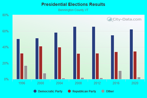
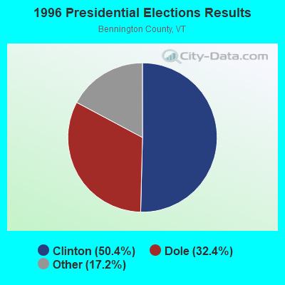
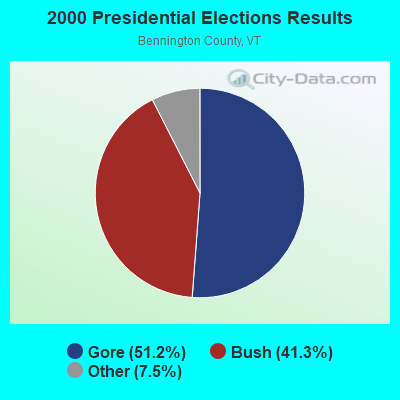
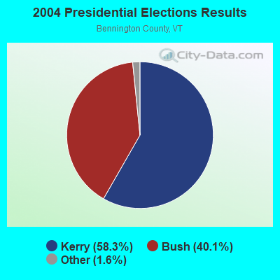
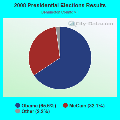
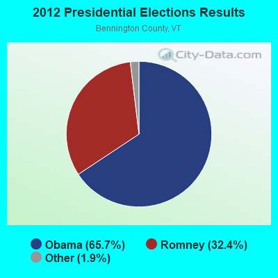
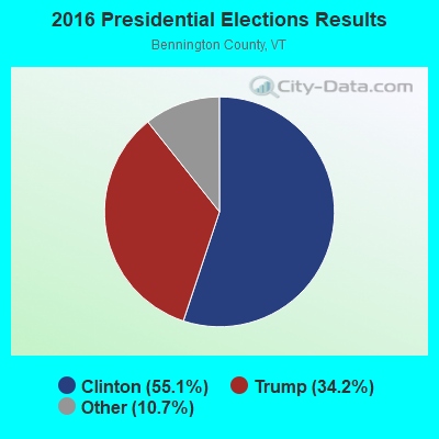
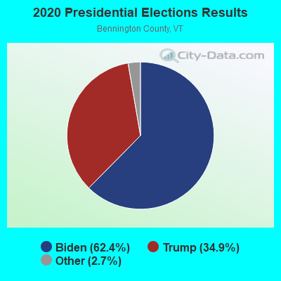
Graphs represent county-level data. Detailed 2008 Election Results
Religion statistics for Sunderland, VT (based on Bennington County data)

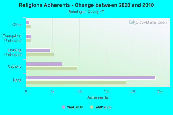
| Religion | Adherents | Congregations |
|---|---|---|
| Catholic | 6,742 | 8 |
| Mainline Protestant | 4,490 | 26 |
| Evangelical Protestant | 1,005 | 12 |
| Other | 693 | 5 |
| None | 24,195 | - |
Food Environment Statistics:
| Bennington County: | 3.85 / 10,000 pop. |
| Vermont: | 3.84 / 10,000 pop. |
| Bennington County: | 3.30 / 10,000 pop. |
| Vermont: | 1.95 / 10,000 pop. |
| Bennington County: | 5.77 / 10,000 pop. |
| Vermont: | 6.40 / 10,000 pop. |
| Here: | 16.48 / 10,000 pop. |
| Vermont: | 11.52 / 10,000 pop. |
| Here: | 8.4% |
| State: | 6.8% |
| Bennington County: | 22.9% |
| State: | 22.3% |
| This county: | 11.6% |
| Vermont: | 13.3% |
Strongest AM radio stations in Sunderland:
- WGY (810 AM; 50 kW; SCHENECTADY, NY; Owner: CLEAR CHANNEL BROADCASTING LICENSES, INC.)
- WNNZ (640 AM; 50 kW; WESTFIELD, MA; Owner: CLEAR CHANNEL BROADCASTING LICENSES, INC.)
- WPTR (1540 AM; 50 kW; ALBANY, NY; Owner: KIMTRON, INC.)
- WCRN (830 AM; 50 kW; WORCESTER, MA; Owner: CARTER BROADCASTING CORPORATION)
- WRKO (680 AM; 50 kW; BOSTON, MA; Owner: ENTERCOM BOSTON LICENSE, LLC)
- WTIC (1080 AM; 50 kW; HARTFORD, CT; Owner: INFINITY RADIO OPERATIONS INC.)
- WVNE (760 AM; daytime; 25 kW; LEICESTER, MA; Owner: BLOUNT MASSCOM, INC.)
- WEEI (850 AM; 50 kW; BOSTON, MA; Owner: ENTERCOM BOSTON LICENSE, LLC)
- WALE (990 AM; 50 kW; GREENVILLE, RI; Owner: NORTH AMERICAN BROADCASTING CO., INC.)
- WBTN (1370 AM; 1 kW; BENNINGTON, VT; Owner: SOUTHERN VERMONT COLLEGE)
- WKOX (1200 AM; 50 kW; FRAMINGHAM, MA; Owner: CAPSTAR TX LIMITED PARTNERSHIP)
- WABY (1160 AM; 5 kW; MECHANICVILLE, NY; Owner: ANASTOS MEDIA GROUP, INC.)
- WIZZ (1520 AM; daytime; 10 kW; GREENFIELD, MA; Owner: P. & M. RADIO, LLC)
Strongest FM radio stations in Sunderland:
- WEQX (102.7 FM; MANCHESTER, VT; Owner: NORTHSHIRE COMMUNICATIONS, INC.)
- WJAN (95.1 FM; SUNDERLAND, VT; Owner: 6 JOHNSON ROAD LICENSES, INC.)
- WVAY (100.7 FM; WILMINGTON, VT; Owner: GREAT NORTHERN RADIO, L.L.C.)
- WNGN (91.9 FM; ARGYLE, NY; Owner: NORTHEAST GOSPEL BROADCASTING INC)
- WAMC-FM (90.3 FM; ALBANY, NY; Owner: WAMC)
- WJJR (98.1 FM; RUTLAND, VT; Owner: 6 JOHNSON ROAD LICENSES, INC.)
- WZRT (97.1 FM; RUTLAND, VT; Owner: CAPSTAR TX LIMITED PARTNERSHIP)
- WEBK (105.3 FM; KILLINGTON, VT; Owner: 6 JOHNSON ROAD LICENSES, INC.)
- WGLV (91.7 FM; WOODSTOCK, VT; Owner: CHRISTIAN MINISTRIES INC)
- WHDQ-FM1 (106.1 FM; RUTLAND, VT; Owner: GREAT NORTHERN RADIO, L.L.C.)
- WZEC (97.5 FM; HOOSICK FALLS, NY; Owner: GREAT NORTHERN RADIO, LLC)
- WVPR (89.5 FM; WINDSOR, VT; Owner: VERMONT PUBLIC RADIO)
- WHDQ (106.1 FM; CLAREMONT, NH; Owner: GREAT NORTHERN RADIO, L.L.C.)
- WLJH (90.9 FM; GLENS FALLS, NY; Owner: SOUND OF LIFE INC)
- WCMK (91.9 FM; PUTNEY, VT; Owner: CHRISTIAN MINISTRIES INC)
- WRSY (101.5 FM; MARLBORO, VT; Owner: GREAT NORTHERN RADIO, L.L.C.)
- WKBE (100.3 FM; WARRENSBURG, NY; Owner: 6 JOHNSON ROAD LICENSES, INC.)
- WCKM-FM (99.1 FM; LAKE GEORGE, NY; Owner: ENTERTRONICS, INC.)
- WNYQ (105.7 FM; QUEENSBURY, NY; Owner: VOX NEW YORK, L.L.C.)
- WKVT-FM (92.7 FM; BRATTLEBORO, VT; Owner: SAGA COMMUNICATIONS OF NEW ENGLAND, LLC)
TV broadcast stations around Sunderland:
- W36AX (Channel 36; MANCHESTER, ETC., VT; Owner: VERMONT ETV, INC.)
- W69AD (Channel 69; BENNINGTON, ETC., VT; Owner: MT. MANSFIELD TELEVISION, INC.)
- WVBK-LP (Channel 49; MANCHESTER, ETC., VT; Owner: VISION 3 BROADCASTING, INC.)
- Sunderland, Vermont
- Fatal accident count10
- Vehicles involved in fatal accidents20
- Fatal accidents involving drunk persons:2
- Fatalities12
- Persons involved in fatal accidents37
- Pedestrians involved in fatal accidents0
- Vermont average
- Fatal accident count748
- Vehicles involved in fatal accidents1056
- Fatal accidents involving drunk persons339
- Fatalities823
- Persons involved in fatal accidents1699
- Pedestrians involved in fatal accidents56
- National Bridge Inventory (NBI) Statistics
- 20Number of bridges
- 141ft / 42.8mTotal length
- $3,322,000Total costs
- 35,100Total average daily traffic
- 2,814Total average daily truck traffic
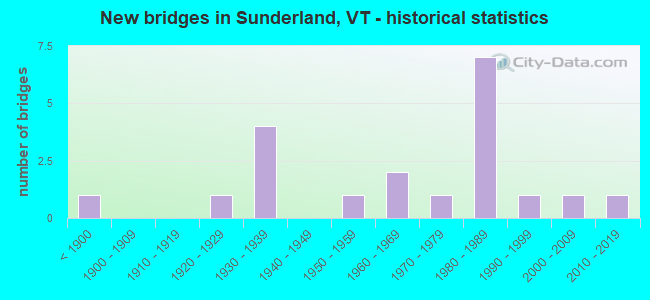
- New bridges - historical statistics
- 1Before 1900
- 11920-1929
- 41930-1939
- 11950-1959
- 21960-1969
- 11970-1979
- 71980-1989
- 11990-1999
- 12000-2009
- 12010-2019
FCC Registered Broadcast Land Mobile Towers:
1- Lat: 43.104722 Lon: -73.119083, Call Sign: WRAK374,
Assigned Frequencies: 153.935 MHz, Grant Date: 12/12/2017, Expiration Date: 12/12/2027, Certifier: Paul Ennis, Registrant: Cara Enterprises, Inc, Las Vegas, NV 89140-0124, Phone: (702) 838-9728, Fax: (702) 363-4607, Email:
FCC Registered Amateur Radio Licenses:
3- Call Sign: WA1DLA, Licensee ID: L00274802, Grant Date: 08/12/2013, Expiration Date: 11/09/2023, Certifier: John H Evans, Registrant: John H Evans, 1789 Sunderland Hill Rd, Sunderland, VT 05250-9748
- Call Sign: KB1JOM, Licensee ID: L00652574, Grant Date: 02/19/2014, Expiration Date: 02/19/2024, Cancellation Date: 04/16/2022, Certifier: Morgan J Kelley, Registrant: Morgan J Kelley, 764, Dunlap Farm Road, Sunderland, VT 05250
- Call Sign: W1MJK, Previous Call Sign: KB1JOM, Licensee ID: L00652574, Grant Date: 04/16/2022, Expiration Date: 04/16/2032, Certifier: Morgan J Kelley 282, Registrant: Morgan J Kelley, 764 Dunlap Farm Road, Sunderland, VT 05250
FAA Registered Aircraft:
2- Aircraft: CESSNA 172S (Category: Land, Seats: 4, Weight: Up to 12,499 Pounds), Engine: Reciprocating
N-Number: 5296D, N5296D, N-5296D, Serial Number: 172S9239, Certificate Issue Date: 05/21/2009
Registrant (Individual): Gary J Zack, 2092 Sunderland Hill Rd, Sunderland, VT 05250
Deregistered: Cancel Date: 03/11/1999, Exported to: Canada - Aircraft: CESSNA 172B (Category: Land, Seats: 4, Weight: Up to 12,499 Pounds, Speed: 105 mph), Engine: CONT MOTOR 0-300 SER (145 HP) (Reciprocating)
N-Number: 8019X, N8019X, N-8019X, Serial Number: 17248519, Year manufactured: 1961, Airworthiness Date: 04/27/1961, Certificate Issue Date: 02/08/2017
Registrant (Co-Owned): Gary V Townsend, 42 Borough Rd, Sunderland, VT 05250, Other Owners: Edwin W Warren

- 78.2%Fuel oil, kerosene, etc.
- 10.9%Wood
- 8.1%Bottled, tank, or LP gas
- 2.8%Electricity

- 54.5%Fuel oil, kerosene, etc.
- 19.7%Wood
- 16.7%Bottled, tank, or LP gas
- 9.1%Electricity
Sunderland compared to Vermont state average:
- Unemployed percentage below state average.
- Black race population percentage significantly below state average.
- Foreign-born population percentage significantly below state average.
- Renting percentage significantly below state average.
- Length of stay since moving in significantly above state average.
- Number of rooms per house significantly below state average.
- House age significantly below state average.
- Number of college students below state average.

|
Total of 3 patent applications in 2008-2024.