St. Agatha, Maine
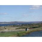
St. Agatha: Cyr Cove St. Agatha Maine - copyright Tardif Family Camp Rentals
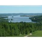
St. Agatha: Long Lake St. Agatha Maine

St. Agatha: Long Lake, St. Agatha
- add
your
Submit your own pictures of this town and show them to the world
- OSM Map
- General Map
- Google Map
- MSN Map
Population change since 2000: -6.9%
 |
| Males: 384 | |
| Females: 363 |
| Median resident age: | 51.6 years |
| Maine median age: | 43.0 years |
Zip codes: 04772.
| St. Agatha: | $54,952 |
| ME: | $69,543 |
Estimated per capita income in 2022: $32,061 (it was $15,535 in 2000)
St. Agatha town income, earnings, and wages data
Estimated median house or condo value in 2022: $166,823 (it was $68,900 in 2000)
| St. Agatha: | $166,823 |
| ME: | $290,600 |
Mean prices in 2022: all housing units: $179,108; detached houses: $185,023; townhouses or other attached units: $218,327; in 2-unit structures: $262,505; in 3-to-4-unit structures: $121,406; in 5-or-more-unit structures: $185,084; mobile homes: $117,009; occupied boats, rvs, vans, etc.: $12,682
Detailed information about poverty and poor residents in St. Agatha, ME
Compare current foreclosures near St. Agatha, ME:
| Photo | Address | Area | Beds / Baths | Price | Details |
|---|---|---|---|---|---|

|
#1
Us Route 1
Frenchville, ME 04745
|
- sq. feet
|
- baths - beds |
show details | |

|
#2
7th Ave
Madawaska, ME 04756
|
- sq. feet
|
- baths - beds |
show details | |

|
#3
Morneault Rd
Grand Isle, ME 04746
|
- sq. feet
|
- baths - beds |
show details | |

|
#4
Cremerie St
Grand Isle, ME 04746
|
- sq. feet
|
- baths - beds |
show details | |

|
#5
Sly Brook Rd
Wallagrass, ME 04781
|
- sq. feet
|
- baths - beds |
show details | |

|
#6
Sly Brook Rd
Wallagrass, ME 04781
|
- sq. feet
|
- baths - beds |
show details | |

|
#7
Pelletier Rd
Fort Kent, ME 04743
|
- sq. feet
|
- baths - beds |
show details | |

|
#8
12th Ave
Madawaska, ME 04756
|
- sq. feet
|
- baths - beds |
show details | |

|
#9
Pleasant Ave
Madawaska, ME 04756
|
- sq. feet
|
- baths - beds |
show details | |

|
#10
Main St
Madawaska, ME 04756
|
- sq. feet
|
- baths - beds |
show details |
| Photo | Address | Area | Beds / Baths | Price | Details |
|---|---|---|---|---|---|

|
#11
Charette Hill Rd
Fort Kent, ME 04743
|
- sq. feet
|
- baths - beds |
show details | |

|
#12
Charette Hill Rd
Fort Kent, ME 04743
|
- sq. feet
|
- baths - beds |
show details | |

|
Check over 1 million property listings on Foreclosure.com!
|
browse all offers | |||

- 73998.9%White alone
- 20.3%Black alone
- 20.3%American Indian alone
- 20.3%Two or more races
- 10.1%Asian alone
- 10.1%Hispanic

Races in St. Agatha detailed stats: ancestries, foreign born residents, place of birth
 Recent articles from our blog. Our writers, many of them Ph.D. graduates or candidates, create easy-to-read articles on a wide variety of topics.

 | Why Does Northern Maine Feel So Different Than The Rest Of The Northeast? (90 replies) |
| People "from away" and Mainers (10 replies) |
| Possibly relocating to Maine from Texas, Buying Land, etc... (102 replies) |
| Looks like we're getting a 75 mph speed limit (22 replies) |
| Correct pronunciation of Lubec? (53 replies) |
| Best French-Canadian flavor towns in Maine? (19 replies) |
Latest news from St. Agatha, ME collected exclusively by city-data.com from local newspapers, TV, and radio stations
Ancestries: French (43.1%), French Canadian (30.5%), United States (9.7%), English (3.4%), Irish (2.2%), Polish (1.7%).
Current Local Time: EST time zone
Incorporated on 03/17/1899
Elevation: 593 feet
Land area: 29.5 square miles.
Population density: 25 people per square mile (very low).
58 residents are foreign born (6.9% North America).
| This town: | 7.2% |
| Maine: | 2.9% |
| St. Agatha town: | 1.4% ($938) |
| Maine: | 1.5% ($1,417) |
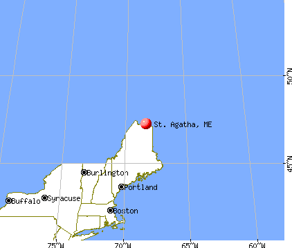
Nearest city with pop. 50,000+: Portland, ME  (264.5 miles , pop. 64,249).
Nearest city with pop. 200,000+: Boston, MA (366.0 miles , pop. 589,141).
Nearest city with pop. 1,000,000+: Bronx, NY (520.6 miles , pop. 1,332,650).
Nearest cities:
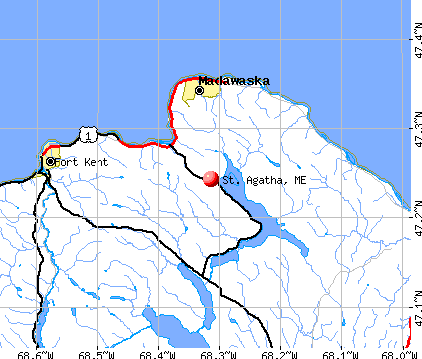
), ), ), ), )Latitude: 47.24 N, Longitude: 68.34 W
Area code commonly used in this area: 207


Single-family new house construction building permits:
- 2022: 4 buildings, average cost: $125,000
- 2021: 4 buildings, average cost: $125,000
- 2020: 3 buildings, average cost: $125,000
- 2019: 3 buildings, average cost: $125,000
- 2018: 3 buildings, average cost: $125,000
- 2017: 3 buildings, average cost: $125,000
- 2016: 3 buildings, average cost: $125,000
- 2014: 2 buildings, average cost: $211,200
- 2013: 1 building, cost: $155,000
- 2012: 3 buildings, average cost: $98,400
- 2011: 3 buildings, average cost: $175,000
- 2010: 4 buildings, average cost: $130,000
- 2009: 3 buildings, average cost: $108,300
- 2007: 3 buildings, average cost: $158,300
- 2006: 3 buildings, average cost: $158,300
- 2005: 4 buildings, average cost: $54,000
- 2004: 2 buildings, average cost: $112,000
- 2003: 2 buildings, average cost: $112,000
- 2002: 2 buildings, average cost: $112,000
- 2001: 4 buildings, average cost: $121,400
- 2000: 10 buildings, average cost: $100,000
- 1999: 3 buildings, average cost: $61,700
- 1997: 2 buildings, average cost: $92,500


| Here: | 4.1% |
| Maine: | 3.4% |


- Paper (19.6%)
- Educational services (12.0%)
- Health care (11.5%)
- Agriculture, forestry, fishing & hunting (10.9%)
- Construction (7.8%)
- Accommodation & food services (5.3%)
- Food & beverage stores (5.0%)

- Paper (29.0%)
- Agriculture, forestry, fishing & hunting (17.1%)
- Construction (12.9%)
- Educational services (6.9%)
- Food & beverage stores (3.7%)
- Motor vehicle & parts dealers (2.8%)
- Accommodation & food services (2.8%)

- Health care (27.9%)
- Educational services (20.0%)
- Accommodation & food services (9.3%)
- Food & beverage stores (7.1%)
- Paper (5.0%)
- Finance & insurance (5.0%)
- Apparel (2.9%)

- Other production occupations, including supervisors (7.8%)
- Agricultural workers, including supervisors (5.0%)
- Material recording, scheduling, dispatching, and distributing workers (4.8%)
- Nursing, psychiatric, and home health aides (4.2%)
- Secretaries and administrative assistants (4.2%)
- Cooks and food preparation workers (4.2%)
- Other office and administrative support workers, including supervisors (4.2%)

- Other production occupations, including supervisors (11.1%)
- Agricultural workers, including supervisors (7.4%)
- Laborers and material movers, hand (6.9%)
- Material recording, scheduling, dispatching, and distributing workers (6.5%)
- Electrical equipment mechanics and other installation, maintenance, and repair workers, including supervisors (6.0%)
- Vehicle and mobile equipment mechanics, installers, and repairers (6.0%)
- Farmers and farm managers (5.5%)

- Nursing, psychiatric, and home health aides (10.7%)
- Secretaries and administrative assistants (10.7%)
- Cashiers (7.9%)
- Preschool, kindergarten, elementary, and middle school teachers (7.1%)
- Cooks and food preparation workers (6.4%)
- Other office and administrative support workers, including supervisors (6.4%)
- Other sales and related occupations, including supervisors (5.0%)
Average climate in St. Agatha, Maine
Based on data reported by over 4,000 weather stations


(lower is better)

Air Quality Index (AQI) level in 2022 was 27.1. This is significantly better than average.
| City: | 27.1 |
| U.S.: | 72.6 |

Particulate Matter (PM10) [µg/m3] level in 2022 was 10.6. This is significantly better than average. Closest monitor was 7.8 miles away from the city center.
| City: | 10.6 |
| U.S.: | 19.2 |
Earthquake activity:
St. Agatha-area historical earthquake activity is above Maine state average. It is 88% smaller than the overall U.S. average.On 7/14/2006 at 09:34:48, a magnitude 3.9 (3.9 MD, Depth: 8.6 mi, Class: Light, Intensity: II - III) earthquake occurred 30.1 miles away from the city center
On 4/20/2002 at 10:50:47, a magnitude 5.3 (5.3 ML, Depth: 3.0 mi, Class: Moderate, Intensity: VI - VII) earthquake occurred 319.6 miles away from the city center
On 4/20/2002 at 10:50:47, a magnitude 5.2 (5.2 MB, 4.2 MS, 5.2 MW, 5.0 MW) earthquake occurred 321.5 miles away from the city center
On 10/7/1983 at 10:18:46, a magnitude 5.3 (5.1 MB, 5.3 LG, 5.1 ML) earthquake occurred 368.8 miles away from St. Agatha center
On 10/16/2012 at 23:12:25, a magnitude 4.7 (4.7 ML, Depth: 10.0 mi, Class: Light, Intensity: IV - V) earthquake occurred 276.0 miles away from the city center
On 1/19/1982 at 00:14:42, a magnitude 4.7 (4.5 MB, 4.7 MD, 4.5 LG) earthquake occurred 303.4 miles away from St. Agatha center
Magnitude types: regional Lg-wave magnitude (LG), body-wave magnitude (MB), duration magnitude (MD), local magnitude (ML), surface-wave magnitude (MS), moment magnitude (MW)
Natural disasters:
The number of natural disasters in Aroostook County (22) is greater than the US average (15).Major Disasters (Presidential) Declared: 13
Emergencies Declared: 9
Causes of natural disasters: Floods: 10, Storms: 8, Snows: 7, Heavy Rains: 2, Blizzard: 1, Hurricane: 1, Ice Storm: 1, Snowfall: 1, Snowstorm: 1, Wind: 1, Winter Storm: 1, Other: 2 (Note: some incidents may be assigned to more than one category).

Colleges/universities with over 2000 students nearest to St. Agatha:
- University of Maine (about 164 miles; Orono, ME; Full-time enrollment: 8,931)
- Husson University (about 169 miles; Bangor, ME; FT enrollment: 2,421)
- University of Maine at Farmington (about 199 miles; Farmington, ME; FT enrollment: 2,036)
- University of Maine at Augusta (about 213 miles; Augusta, ME; FT enrollment: 3,204)
- Saint Joseph's College of Maine (about 259 miles; Standish, ME; FT enrollment: 2,010)
- University of Southern Maine (about 265 miles; Portland, ME; FT enrollment: 6,647)
- Southern Maine Community College (about 265 miles; South Portland, ME; FT enrollment: 4,666)
Public high school in St. Agatha:
- WISDOM MIDDLE HIGH SCHOOL (Location: 368 MAIN ST 69, Grades: 7-12)
Points of interest:
Notable location: Saint Agatha Volunteer Fire Department (A). Display/hide its location on the map
Church in St. Agatha: Saint Agatha Church (A). Display/hide its location on the map
Cemetery: Saint Agatha Cemetery (1). Display/hide its location on the map
Lakes: Brishlotte Lake (A), Long Lake (B). Display/hide their locations on the map
Streams, rivers, and creeks: Factory Brook (A), Ouellette Brook (B). Display/hide their locations on the map
| This town: | 2.1 people |
| Maine: | 2.3 people |
| This town: | 60.2% |
| Whole state: | 62.9% |
| This town: | 6.7% |
| Whole state: | 9.4% |
Likely homosexual households (counted as self-reported same-sex unmarried-partner households)
- Lesbian couples: 0.0% of all households
- Gay men: 0.3% of all households
| This town: | 10.0% |
| Whole state: | 10.9% |
| This town: | 4.5% |
| Whole state: | 4.1% |
2 people in agriculture workers' dormitories on farms in 2000
For population 15 years and over in St. Agatha:

- Never married: 22.5%
- Now married: 62.7%
- Separated: 0.3%
- Widowed: 7.8%
- Divorced: 6.8%
For population 25 years and over in St. Agatha:
- High school or higher: 75.2%
- Bachelor's degree or higher: 10.6%
- Graduate or professional degree: 3.4%
- Unemployed: 6.3%
- Mean travel time to work (commute): 17.1 minutes


| Here: | 12.5 |
| Maine average: | 11.2 |


Graphs represent county-level data. Detailed 2008 Election Results
Religion statistics for St. Agatha, ME (based on Aroostook County data)


| Religion | Adherents | Congregations |
|---|---|---|
| Catholic | 22,200 | 27 |
| Mainline Protestant | 5,845 | 40 |
| Evangelical Protestant | 4,411 | 51 |
| Other | 957 | 7 |
| Orthodox | 10 | 1 |
| None | 38,447 | - |
Food Environment Statistics:
| Aroostook County: | 4.03 / 10,000 pop. |
| Maine: | 2.80 / 10,000 pop. |
| Aroostook County: | 0.14 / 10,000 pop. |
| State: | 0.14 / 10,000 pop. |
| Aroostook County: | 2.22 / 10,000 pop. |
| Maine: | 2.20 / 10,000 pop. |
| This county: | 7.78 / 10,000 pop. |
| State: | 5.75 / 10,000 pop. |
| Aroostook County: | 9.17 / 10,000 pop. |
| Maine: | 11.02 / 10,000 pop. |
| Here: | 11.7% |
| State: | 8.2% |
| Aroostook County: | 27.6% |
| Maine: | 25.0% |
Strongest AM radio stations in St. Agatha:
- WFST (600 AM; 5 kW; CARIBOU, ME; Owner: NORTHERN BROADCAST MINISTRIES, INC.)
- WEGP (1390 AM; 5 kW; PRESQUE ISLE, ME; Owner: DECELLES/SMITH MEDIA, INC.)
- WREM (710 AM; daytime; 5 kW; MONTICELLO, ME; Owner: ALLAN H WEINER)
- WRKO (680 AM; 50 kW; BOSTON, MA; Owner: ENTERCOM BOSTON LICENSE, LLC)
- WCHP (760 AM; 35 kW; CHAMPLAIN, NY; Owner: CHAMPLAIN RADIO, INC.)
- WNNZ (640 AM; 50 kW; WESTFIELD, MA; Owner: CLEAR CHANNEL BROADCASTING LICENSES, INC.)
- WEEI (850 AM; 50 kW; BOSTON, MA; Owner: ENTERCOM BOSTON LICENSE, LLC)
- WCRN (830 AM; 50 kW; WORCESTER, MA; Owner: CARTER BROADCASTING CORPORATION)
- WBZ (1030 AM; 50 kW; BOSTON, MA; Owner: INFINITY BROADCASTING OPERATIONS, INC.)
- WGY (810 AM; 50 kW; SCHENECTADY, NY; Owner: CLEAR CHANNEL BROADCASTING LICENSES, INC.)
- WICY (1490 AM; 50 kW; MALONE, NY; Owner: CARTIER COMMUNICATIONS INC.)
- WALE (990 AM; 50 kW; GREENVILLE, RI; Owner: NORTH AMERICAN BROADCASTING CO., INC.)
- WKOX (1200 AM; 50 kW; FRAMINGHAM, MA; Owner: CAPSTAR TX LIMITED PARTNERSHIP)
Strongest FM radio stations in St. Agatha:
- WCXX (102.3 FM; MADAWASKA, ME; Owner: THE CANXUS BROADCASTING CORPORATION)
- WMEF (106.5 FM; FORT KENT, ME; Owner: MAINE PUBLIC BROADCASTING CORP)
- WBPW (96.9 FM; PRESQUE ISLE, ME; Owner: CITADEL BROADCASTING COMPANY)
TV broadcast stations around St. Agatha:
- W17BN (Channel 17; MADAWASKA, ME; Owner: TRINITY BROADCASTING NETWORK)
- W11AA (Channel 11; MADAWASKA, ME; Owner: NEPSK, INC.)
St. Agatha fatal accident list:
Oct 20, 2008 05:25 PM, Bouchard Road, Lat: 47.204170, Lon: -68.378220, Vehicles: 1, Persons: 1, Fatalities: 1
May 25, 2002 09:45 AM, Main Street, Vehicles: 1, Persons: 1, Fatalities: 1
Jan 5, 2001 00:05 AM, Sr-162, Vehicles: 1, Persons: 2, Pedestrians: 1, Fatalities: 1, Drunk persons involved: 1
Jan 17, 1997 11:50 PM, 162, Vehicles: 1, Persons: 2, Fatalities: 1, Drunk persons involved: 1
Jan 19, 1995 07:55 AM, 162, Vehicles: 2, Persons: 2, Fatalities: 1
Aug 27, 1978 06:21 PM, Vehicles: 1, Persons: 1, Fatalities: 1, Drunk persons involved: 1
- National Bridge Inventory (NBI) Statistics
- 1Number of bridges
- 3ft / 1.0mTotal length
- 516Total average daily traffic
- 25Total average daily truck traffic
- 826Total future (year 2036) average daily traffic
FCC Registered Broadcast Land Mobile Towers:
1- Lat: 47.245389 Lon: -68.313833, Call Sign: WNAN638,
Assigned Frequencies: 154.362 MHz, Grant Date: 10/28/2021, Expiration Date: 10/02/2031, Registrant: New Wave Licensing Services Inc., 517 Sachs Road, Gettysburg, PA 17325, Phone: (717) 334-0910, Fax: (717) 334-4739, Email:

- 90.6%Fuel oil, kerosene, etc.
- 8.7%Wood
- 0.8%Electricity

- 78.6%Fuel oil, kerosene, etc.
- 7.1%Coal or coke
- 4.8%Electricity
- 4.8%Wood
- 4.8%No fuel used
St. Agatha compared to Maine state average:
- Median house value below state average.
- Unemployed percentage below state average.
- Black race population percentage significantly below state average.
- Hispanic race population percentage significantly below state average.
- Median age significantly above state average.
- Foreign-born population percentage above state average.
- Length of stay since moving in significantly above state average.
- Number of rooms per house significantly below state average.
- House age significantly below state average.
- Number of college students below state average.
- Percentage of population with a bachelor's degree or higher significantly below state average.
St. Agatha on our top lists:
- #28 on the list of "Top 101 cities with the most residents born in Northern America (population 500+)"
- #28 on the list of "Top 101 cities with the most residents born in Canada (population 500+)"
- #43 (04772) on the list of "Top 101 zip codes with the largest percentage of French Canadian first ancestries"
- #19 on the list of "Top 101 counties with the highest carbon monoxide air pollution readings in 2012 (ppm)"
- #22 on the list of "Top 101 counties with the smallest number of children under 18 without health insurance coverage in 2000 (pop. 50,000+)"
- #29 on the list of "Top 101 counties with the lowest percentage of residents relocating from other counties between 2010 and 2011"
- #34 on the list of "Top 101 counties with the lowest percentage of residents relocating to other counties in 2011"
- #46 on the list of "Top 101 counties with the lowest Particulate Matter (PM2.5) Annual air pollution readings in 2012 (µg/m3)"
State forum archive: