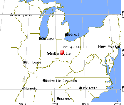
Springfield, Ohio

Springfield: Reflection

Springfield: Art Museum

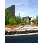
Springfield: Fountain

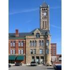
Springfield: Heritage Center

Springfield: Memorial Hall
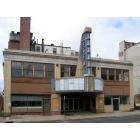
Springfield: Springfield OH Regent Theater
Springfield: Springfield OH Library
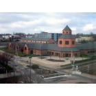
Springfield: Heritage Center of Clark County, Springfield OH
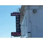
Springfield: Schuler's Bakery on the Old National Road
Springfield: DT Springfield
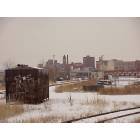
Springfield: City of Springfield Oh from train tracks
- add
your
Submit your own pictures of this city and show them to the world
- OSM Map
- General Map
- Google Map
- MSN Map
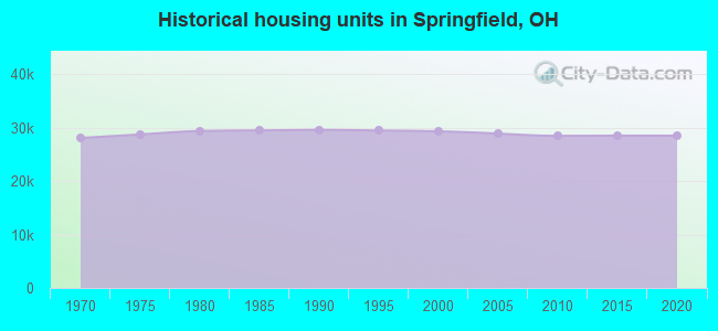
Population change since 2000: -11.1%
 |
| Males: 28,071 | |
| Females: 30,035 |
| Median resident age: | 36.8 years |
| Ohio median age: | 39.9 years |
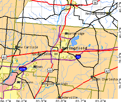
Zip codes: 45504, 45505, 45506.
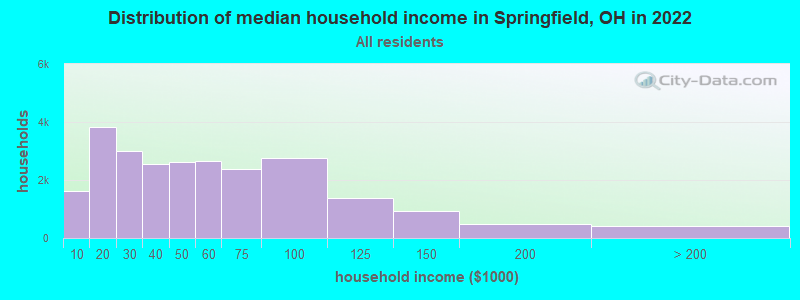
Springfield Zip Code Map| Springfield: | $42,954 |
| OH: | $65,720 |
Estimated per capita income in 2022: $25,348 (it was $16,660 in 2000)
Springfield city income, earnings, and wages data
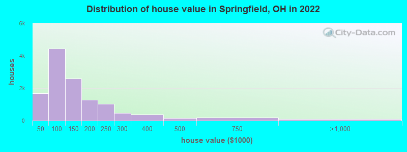
Estimated median house or condo value in 2022: $114,642 (it was $69,300 in 2000)
| Springfield: | $114,642 |
| OH: | $204,100 |
Mean prices in 2022: all housing units: $139,250; detached houses: $135,766; townhouses or other attached units: $170,462; in 2-unit structures: $183,637; in 3-to-4-unit structures: $304,461; in 5-or-more-unit structures: $135,477; mobile homes: $16,564
Median gross rent in 2022: $821.
(18.7% for White Non-Hispanic residents, 29.4% for Black residents, 39.0% for Hispanic or Latino residents, 86.8% for American Indian residents, 28.2% for Native Hawaiian and other Pacific Islander residents, 72.5% for other race residents, 33.6% for two or more races residents)
Detailed information about poverty and poor residents in Springfield, OH


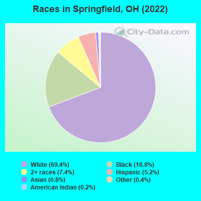
- 40,37169.4%White alone
- 9,75016.8%Black alone
- 4,3207.4%Two or more races
- 3,0485.2%Hispanic
- 4920.8%Asian alone
- 2110.4%Other race alone
- 1020.2%American Indian alone
- 290.05%Native Hawaiian and Other
Pacific Islander alone
Races in Springfield detailed stats: ancestries, foreign born residents, place of birth
According to our research of Ohio and other state lists, there were 199 registered sex offenders living in Springfield, Ohio as of May 16, 2024.
The ratio of all residents to sex offenders in Springfield is 301 to 1.
The City-Data.com crime index weighs serious crimes and violent crimes more heavily. Higher means more crime, U.S. average is 246.1. It adjusts for the number of visitors and daily workers commuting into cities.
- means the value is about the same as the state average.- means the value is bigger than the state average.
- means the value is much bigger than the state average.
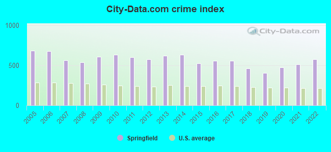
Crime rate in Springfield detailed stats: murders, rapes, robberies, assaults, burglaries, thefts, arson
Full-time law enforcement employees in 2020, including police officers: 134 (124 officers - 107 male; 17 female).
| Officers per 1,000 residents here: | 2.11 |
| Ohio average: | 2.24 |
 Recent articles from our blog. Our writers, many of them Ph.D. graduates or candidates, create easy-to-read articles on a wide variety of topics.


Latest news from Springfield, OH collected exclusively by city-data.com from local newspapers, TV, and radio stations
Ancestries: German (12.3%), American (11.4%), English (7.2%), Irish (6.3%), Italian (3.4%), European (1.7%).
Current Local Time: EST time zone
Incorporated in 1913
Elevation: 1000 feet
Land area: 22.5 square miles.
Population density: 2,586 people per square mile (average).
1,837 residents are foreign born (2.0% Latin America, 0.5% Asia).
| This city: | 3.2% |
| Ohio: | 4.9% |
Median real estate property taxes paid for housing units with mortgages in 2022: $1,420 (1.2%)
Median real estate property taxes paid for housing units with no mortgage in 2022: $1,221 (1.2%)
Nearest city with pop. 200,000+: Columbus, OH  (43.3 miles , pop. 711,470).
Nearest city with pop. 1,000,000+: Chicago, IL (242.0 miles , pop. 2,896,016).
Nearest cities:
), ), ), ), ), ), Latitude: 39.93 N, Longitude: 83.80 W
Daytime population change due to commuting: +6,024 (+10.4%)
Workers who live and work in this city: 13,094 (54.7%)
Area code: 937

Springfield, Ohio accommodation & food services, waste management - Economy and Business Data
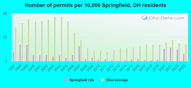
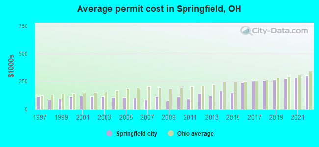
Single-family new house construction building permits:
- 2022: 64 buildings, average cost: $302,100
- 2021: 76 buildings, average cost: $282,700
- 2020: 69 buildings, average cost: $277,900
- 2019: 10 buildings, average cost: $265,800
- 2018: 5 buildings, average cost: $258,600
- 2017: 6 buildings, average cost: $257,900
- 2016: 11 buildings, average cost: $242,800
- 2015: 11 buildings, average cost: $149,600
- 2014: 8 buildings, average cost: $168,600
- 2013: 3 buildings, average cost: $121,600
- 2012: 8 buildings, average cost: $139,900
- 2011: 11 buildings, average cost: $93,600
- 2010: 9 buildings, average cost: $118,800
- 2009: 20 buildings, average cost: $76,100
- 2008: 11 buildings, average cost: $119,400
- 2007: 84 buildings, average cost: $81,700
- 2006: 36 buildings, average cost: $99,900
- 2005: 20 buildings, average cost: $108,800
- 2004: 33 buildings, average cost: $111,600
- 2003: 25 buildings, average cost: $120,500
- 2002: 35 buildings, average cost: $121,300
- 2001: 34 buildings, average cost: $121,800
- 2000: 35 buildings, average cost: $119,100
- 1999: 91 buildings, average cost: $90,500
- 1998: 93 buildings, average cost: $86,400
- 1997: 53 buildings, average cost: $117,400
| Here: | 3.6% |
| Ohio: | 3.1% |
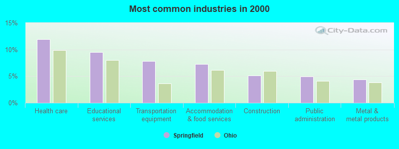
- Health care (11.9%)
- Educational services (9.5%)
- Transportation equipment (7.8%)
- Accommodation & food services (7.2%)
- Construction (5.1%)
- Public administration (4.9%)
- Metal & metal products (4.4%)
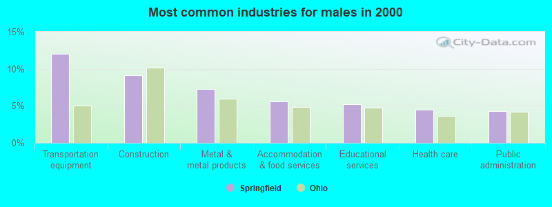
- Transportation equipment (12.0%)
- Construction (9.2%)
- Metal & metal products (7.2%)
- Accommodation & food services (5.6%)
- Educational services (5.2%)
- Health care (4.5%)
- Public administration (4.3%)
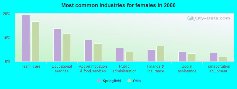
- Health care (19.5%)
- Educational services (13.8%)
- Accommodation & food services (8.9%)
- Public administration (5.6%)
- Finance & insurance (5.0%)
- Social assistance (4.0%)
- Transportation equipment (3.6%)
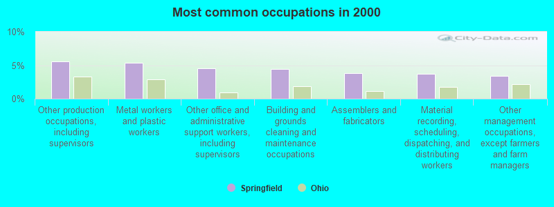
- Other production occupations, including supervisors (5.6%)
- Metal workers and plastic workers (5.3%)
- Other office and administrative support workers, including supervisors (4.5%)
- Building and grounds cleaning and maintenance occupations (4.5%)
- Assemblers and fabricators (3.9%)
- Material recording, scheduling, dispatching, and distributing workers (3.7%)
- Other management occupations, except farmers and farm managers (3.4%)
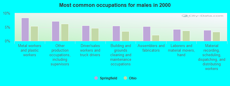
- Metal workers and plastic workers (8.3%)
- Other production occupations, including supervisors (7.1%)
- Driver/sales workers and truck drivers (5.5%)
- Building and grounds cleaning and maintenance occupations (5.5%)
- Assemblers and fabricators (5.3%)
- Laborers and material movers, hand (4.2%)
- Material recording, scheduling, dispatching, and distributing workers (3.9%)
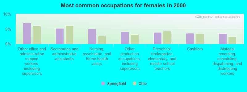
- Other office and administrative support workers, including supervisors (7.1%)
- Secretaries and administrative assistants (5.2%)
- Nursing, psychiatric, and home health aides (5.1%)
- Other production occupations, including supervisors (4.1%)
- Preschool, kindergarten, elementary, and middle school teachers (3.9%)
- Cashiers (3.6%)
- Material recording, scheduling, dispatching, and distributing workers (3.5%)
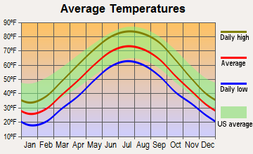
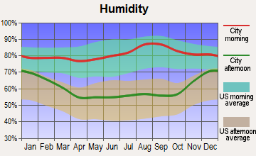
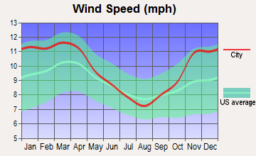
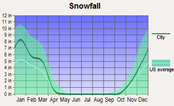
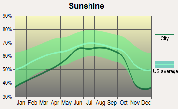
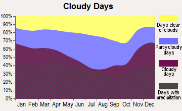
Average climate in Springfield, Ohio
Based on data reported by over 4,000 weather stations
|
|

(lower is better)
Air Quality Index (AQI) level in 2023 was 97.5. This is worse than average.
| City: | 97.5 |
| U.S.: | 72.6 |

Carbon Monoxide (CO) [ppm] level in 2010 was 0.300. This is about average. Closest monitor was 0.6 miles away from the city center.
| City: | 0.300 |
| U.S.: | 0.251 |
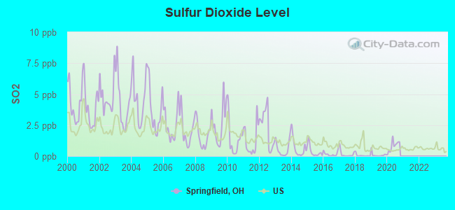
Sulfur Dioxide (SO2) [ppb] level in 2020 was 0.813. This is significantly better than average. Closest monitor was 0.3 miles away from the city center.
| City: | 0.813 |
| U.S.: | 1.515 |
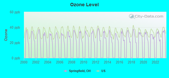
Ozone [ppb] level in 2022 was 28.9. This is about average. Closest monitor was 0.6 miles away from the city center.
| City: | 28.9 |
| U.S.: | 33.3 |
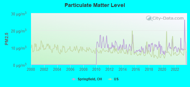
Particulate Matter (PM2.5) [µg/m3] level in 2023 was 12.2. This is significantly worse than average. Closest monitor was 0.3 miles away from the city center.
| City: | 12.2 |
| U.S.: | 8.1 |
Tornado activity:
Springfield-area historical tornado activity is slightly above Ohio state average. It is 44% greater than the overall U.S. average.
On 4/3/1974, a category F5 (max. wind speeds 261-318 mph) tornado 10.8 miles away from the Springfield city center killed 36 people and injured 1150 people and caused between $50,000,000 and $500,000,000 in damages.
On 9/20/2000, a category F4 (max. wind speeds 207-260 mph) tornado 14.2 miles away from the city center killed one person and injured 100 people and caused $15 million in damages.
Earthquake activity:
Springfield-area historical earthquake activity is significantly above Ohio state average. It is 14% greater than the overall U.S. average.On 7/27/1980 at 18:52:21, a magnitude 5.2 (5.1 MB, 4.7 MS, 5.0 UK, 5.2 UK, Class: Moderate, Intensity: VI - VII) earthquake occurred 119.3 miles away from Springfield center
On 7/12/1986 at 08:19:37, a magnitude 4.5 (4.5 MB, Class: Light, Intensity: IV - V) earthquake occurred 51.7 miles away from Springfield center
On 4/18/2008 at 09:36:59, a magnitude 5.4 (5.1 MB, 4.8 MS, 5.4 MW, 5.2 MW) earthquake occurred 241.4 miles away from the city center
On 9/25/1998 at 19:52:52, a magnitude 5.2 (4.8 MB, 4.3 MS, 5.2 LG, 4.5 MW, Depth: 3.1 mi) earthquake occurred 208.9 miles away from the city center
On 1/31/1986 at 16:46:43, a magnitude 5.0 (5.0 MB) earthquake occurred 180.6 miles away from the city center
On 8/23/2011 at 17:51:04, a magnitude 5.8 (5.8 MW, Depth: 3.7 mi) earthquake occurred 345.1 miles away from Springfield center
Magnitude types: regional Lg-wave magnitude (LG), body-wave magnitude (MB), surface-wave magnitude (MS), moment magnitude (MW)
Natural disasters:
The number of natural disasters in Clark County (8) is smaller than the US average (15).Major Disasters (Presidential) Declared: 4
Emergencies Declared: 3
Causes of natural disasters: Storms: 2, Winds: 2, Blizzard: 1, Flood: 1, Hurricane: 1, Mudslide: 1, Snow: 1, Snowstorm: 1, Tornado: 1, Tropical Depression: 1, Winter Storm: 1, Other: 1 (Note: some incidents may be assigned to more than one category).
Main business address for: WESTERN OHIO FINANCIAL CORP (SAVINGS INSTITUTION, FEDERALLY CHARTERED).
Hospitals in Springfield:
- COMMUNITY HOSPITAL OF SPRINGFIELD AND CLARK CO,THE (provides emergency services, 2615 EAST HIGH STREET)
- COMMUNITY MERCY HOSPICE (1343 NORTH FOUNTAIN BLVD, 5N)
- CSS - EL CAMINO DRIVE (3154 EL CAMINO DRIVE)
- F F MUELLER RESIDENTIAL SERVICES/SUNSET (2422 SUNSET AVENUE)
- MENTAL HEALTH SERVICES-CLARK COUNTY (1345 FOUNTAIN BOULEVARD)
- OHIO VALLEY MEDICAL CENTER, LLC (Voluntary non-profit - Private, 100 WEST MAIN STREET)
- SPRINGFIELD REGIONAL MEDICAL CENTER (Voluntary non-profit - Private, 100 MEDICAL CENTER DRIVE)
- SPRINGFIELD SURGERY CENTER (2685 E HIGH ST)
- WHISPERING PINES OF SPRINGFIELD (1365 WEST SEMINOLE AVENUE)
Nursing Homes in Springfield:
- CASTLE KNOLL (901 WEST HIGH STREET)
- EAGLEWOOD CARE CENTER (2000 VILLA ROAD)
- FOREST GLEN HEALTH CAMPUS (2150 MONTEGO DRIVE)
- HEARTLAND OF SPRINGFIELD (2615 DERR ROAD)
- MERCY ST JOHN'S CENTER (100 WEST MCCREIGHT AVENUE)
- NEW HORIZONS NURSING HOME (1157 DRISCOLL AVE)
- PILLARS NURSING HOME, LTD (336 WEST COLUMBIA STREET)
- SKILLED NURSING UNIT OF COMMUNITY HOSPITAL (2615 EAST HIGH STREET)
- SPRINGFIELD MASONIC COMMUNITY (2655 W NATIONAL RD)
- ST JOHNS NURSING AND CONV CTR (100 W MCCREIGHT AVENUE)
Dialysis Facilities in Springfield:
- DAVITA - MIDWEST SPRINGFIELD DIALYSIS (2200 N LIMESTONE STREET SUITE 104)
- DAVITA - NATIONAL TRAIL DIALYSIS (171 S. TUTTLE ROAD)
Home Health Centers in Springfield:
Airports and heliports located in Springfield:
- Springfield-Beckley Municipal Airport (SGH) (Runways: 2, Air Taxi Ops: 248, Itinerant Ops: 1,590, Local Ops: 5,638, Military Ops: 1,769)
- Kepes Flying Field Airport (1OA4) (Runways: 1, Itinerant Ops: 100, Local Ops: 400, Military Ops: 10)
- Mercy Medical Center Heliport (6OH0)
- Springfield Regional Medical Center Heliport (OH81)
Colleges/Universities in Springfield:
- Clark State Community College (Full-time enrollment: 3,689; Location: 570 E Leffel Ln; Public; Website: www.clarkstate.edu)
- Wittenberg University (Full-time enrollment: 1,987; Location: Ward St at N Wittenberg Ave; Private, not-for-profit; Website: www.wittenberg.edu; Offers Master's degree)
- Carousel Beauty College-Springfield (Full-time enrollment: 68; Location: 1475 Upper Valley Pike; Private, for-profit; Website: www.carouselbeauty.com)
Other colleges/universities with over 2000 students near Springfield:
- Cedarville University (about 13 miles; Cedarville, OH; Full-time enrollment: 3,396)
- Central State University (about 16 miles; Wilberforce, OH; FT enrollment: 2,094)
- Wright State University-Main Campus (about 18 miles; Dayton, OH; FT enrollment: 14,482)
- University of Dayton (about 24 miles; Dayton, OH; FT enrollment: 10,392)
- Sinclair Community College (about 25 miles; Dayton, OH; FT enrollment: 13,779)
- Fortis College-Centerville (about 27 miles; Centerville, OH; FT enrollment: 4,527)
- Edison State Community College (about 27 miles; Piqua, OH; FT enrollment: 2,049)
Biggest public high schools in Springfield:
- SPRINGFIELD HIGH SCHOOL (Students: 1,868, Location: 701 E HOME RD, Grades: 9-12)
- KENTON RIDGE HIGH SCHOOL (Students: 747, Location: 4444 MIDDLE URBANA RD, Grades: 9-12)
- GREENON HIGH SCHOOL (Students: 659, Location: 3950 S TECUMSEH RD, Grades: 9-12)
- NORTHEASTERN HIGH SCHOOL (Students: 530, Location: 1480 BOWMAN RD, Grades: 9-12)
- CLIFF PARK HIGH SCHOOL (Location: 821 N LIMESTONE ST, Grades: 9-12, Charter school)
- GLOBAL IMPACT STEM ACADEMY (Location: 570 E LEFFEL LN, Grades: 9-10)
- KEIFER ACADEMY (Location: 601 SELMA RD, Grades: 1-12)
- NORTHWESTERN JUNIOR/SENIOR HIGH SCHOOL (Location: 5650 TROY RD, Grades: 6-12)
- SHAWNEE HIGH SCHOOL (Location: 1675 E POSSUM RD, Grades: 9-12)
- SPRINGFIELD-CLARK COUNTY (Location: 1901 SELMA RD, Grades: 7-12)
Private high schools in Springfield:
Biggest public elementary/middle schools in Springfield:
- NORTHWESTERN ELEMENTARY SCHOOL (Students: 674, Location: 5610 TROY RD, Grades: PK-6)
- NORTHRIDGE MIDDLE SCHOOL (Students: 564, Location: 4445 RIDGEWOOD RD E, Grades: 6-8)
- REID ELEMENTARY SCHOOL (Students: 561, Location: 3640 E HIGH ST, Grades: KG-5)
- POSSUM ELEMENTARY SCHOOL (Students: 519, Location: 2589 S YELLOW SPRINGS RD, Grades: KG-5)
- ROLLING HILLS ELEMENTARY SCHOOL (Students: 518, Location: 2613 MOOREFIELD RD, Grades: PK-5)
- SNOWHILL ELEMENTARY SCHOOL (Students: 477, Location: 531 W HARDING RD, Grades: KG-6)
- WARDER PARK-WAYNE ELEMENTARY SCHOOL (Students: 474, Location: 2820 HILLSIDE AVE, Grades: KG-6)
- MANN ELEMENTARY SCHOOL (Students: 469, Location: 521 MOUNT JOY ST, Grades: KG-6)
- PERRIN WOODS ELEMENTARY SCHOOL (Students: 421, Location: 431 W JOHN ST, Grades: KG-6)
- KENWOOD ELEMENTARY (Students: 420, Location: 1421 NAGLEY ST, Grades: KG-6)
Private elementary/middle schools in Springfield:
- CATHOLIC CENTRAL ELEMENTARY SCHOOL - PK-6 (Students: 471, Location: 800 LAGONDA AVE, Grades: PK-6)
- CATHOLIC CENTRAL ELEMENTARY - LIMESTONE CAMPUS (Students: 283, Location: 1817 N LIMESTONE ST, Grades: PK-3)
- RISEN CHRIST LUTHERAN SCHOOL (Students: 102, Location: 41 E POSSUM RD, Grades: PK-6)
- RIDGEWOOD SCHOOL (Students: 89, Location: 2420 SAINT PARIS PIKE, Grades: KG-8)
- SPRINGFIELD CHRISTIAN SCHOOL (Students: 83, Location: 311 W HIGH ST, Grades: PK-8)
- MAIDEN LANE EDUCARE (Students: 12, Location: 1201 MAIDEN LN, Grades: KG-1)
- TWIN OAKS SDA ELEMENTARY SCHOOL (Students: 5, Location: 151 S BIRD RD, Grades: KG-4)
User-submitted facts and corrections:
- Students are now able to complete a high school diploma at Nightingale Montessori. The grade range should be PK-12. Their # is (937) 324-0336.
- Emmanuel Christian Academy is now K-12
- Emmanuel Christian Academy - 385 students, grades k-12, location 2177 Emmanuel Way, phone (937)390-3777
- The Westcott House...desigend and built by the great american architect...Frank Llyod Wright. Located on E. High street.
Points of interest:
Notable locations in Springfield: Weaver Observatory (A), Evans Stadium (B), Municipal Stadium (C), Springfield Country Club (D), Northwood Hills Country Club (E), Springfield Water Treatment Plant (F), Snyder Park Golf Course (G), Reid Memorial Golf Course (H), Primeohio Corporate Park (I), Eaton Medical Transportation Station 5 (J), Med Trans Emergency Medical Services (K), Independent Order of Odd Fellows Home (L), Medcorp Emergency Medical Services (M), Quality Care Transport (N), Bayley Auditorium (O), Clark County Courthouse (P), Clark County Public Library (Q), Ohio Masonic Home (R), Springfield City Hall (S), Thomas Library (T). Display/hide their locations on the map
Shopping Centers: Park Shopping Center (1), Northland Plaza Shopping Center (2), Moorefield Square Shopping Center (3), East Main Plaza Shopping Center (4), Burnett Plaza Shopping Center (5), Western Plaza Shopping Center (6), Southern Village Shopping Center (7), Circus Plaza Shopping Center (8), Bushnell Square Shopping Center (9). Display/hide their locations on the map
Main business address in Springfield: WESTERN OHIO FINANCIAL CORP (A). Display/hide its location on the map
Churches in Springfield include: Third Presbyterian Church (A), Assumption of the Blessed Virgin Mary Greek Orthodox Cathedral (B), Beacon Street Church of Christ in Christian Union (C), Blessed Hope Baptist Church (D), Central Christian Church (E), Church of God (F), Clifton Avenue Church of God (G), Elbethel Temple (H), Fellowship Christian Church (I). Display/hide their locations on the map
Cemeteries: Saint Raphaels Cemetery (1), Old Columbia Street Cemetery (2), Ferncliff Cemetery (3), Greenmount Cemetery (4), Masonic Home Cemetery (5), Childrens Home Cemetery (6), New Comer Cemetery (7). Display/hide their locations on the map
Lake: Culp Lake (A). Display/hide its location on the map
Creek: Mill Creek (A). Display/hide its location on the map
Parks in Springfield include: Willa Park (1), Old Reid Park (2), Lagonda Park (3), East High Street Historic District (4), Davey Moore Park (5), Cliff Park (6), Rose Street Park (7), New Reid Park (8), Snyder Park (9). Display/hide their locations on the map
Tourist attractions: Clark County Historical Society - Crabill Homestead (Cultural Attractions- Events- & Facilities; 2800 Croft Road) (1), Alternative Sports Supply Limited (Amusement & Theme Parks; 1236 Villa Road) (2), Kid Enterprises (Amusement & Theme Parks; 3434 Saint Paris Pike) (3), Classic Coffee (Amusement & Theme Parks; 3434 Saint Paris Pike) (4), Hughes Music CO (Amusement & Theme Parks; 355 South Limestone Street) (5), Forever Sports Canoe Livery (Amusement & Theme Parks; 2237 West 1st Street) (6), Amusement Equipment CO (Amusement & Theme Parks; 3207 East National Road) (7), Convention & Visitors Bureau Springfield Area (333 North Limestone Street Suite 201) (8), Blue Sky Balloons LLC (7070 Ballentine Pike) (9). Display/hide their approximate locations on the map
Hotels: Courtyard by Marriott (100 South Fountain Avenue) (1), Hampton Inn Springfield (101 W Leffel Ln) (2), Country Inn-Suites Springfield (1751 West 1st Street) (3), Comfort Suites Springfield (121 Raydo Circle) (4), Executive Inn (325 West Columbia Street) (5), Drake Self Storage (3200 East National Road) (6), Harmony Motel (4725 East National Road) (7), Harvester Inn (2045 Lagonda Avenue) (8), Fairfax Motel (2418 East Main Street) (9). Display/hide their approximate locations on the map
Courts: Clark County - Juvenile Court Center (101 East Columbia) (1), Clark County - Probate Court (50 East Columbia Street) (2), Springfield City - City Prosecutor- Municipal Court- Law Department- Criminal Divi (50 East Columbia Street) (3), Clark County - Sheriff's Office- Court Deputies (31 North Limestone Street) (4), Clark County Juvenile Court (527 East Home Road) (5). Display/hide their approximate locations on the map
Birthplace of: Mike DeWine - politician, Kevin Donley - Football player and coach, Jennifer Brunner - Politician, Lillian Gish, Jan Finney - Martial artist, Nancy Warren (baseball) - Baseball player, Adam Eaton (outfielder) - Baseball player, Alaina Reed Hall - Actress, Alice Hohlmayer - Girls Professional Baseball League player, Justin Chambers - Film actor.
Drinking water stations with addresses in Springfield and their reported violations in the past:
CLARK COUNTY NORTHRIDGE 1 PWS (Population served: 9,800, Purch groundwater):Past monitoring violations:CENTRAL STATE UNIVERSITY (Population served: 2,051, Groundwater):
- Failure Submit IDSE/Subpart V Plan Rpt - In JUL-02-2009, Contaminant: DBP STAGE 2. Follow-up actions: Fed FAO issued (JUL-02-2009), Fed Compliance achieved (JUN-21-2010)
- Monitoring, Routine (IDSE) - Between APR-2008 and MAR-2009, Contaminant: TTHM. Follow-up actions: Fed FAO issued (JUL-02-2009), Fed Compliance achieved (JUN-21-2010)
- Monitoring, Routine (IDSE) - Between APR-2008 and MAR-2009, Contaminant: Total Haloacetic Acids (HAA5). Follow-up actions: Fed FAO issued (JUL-02-2009), Fed Compliance achieved (JUN-21-2010)
Past monitoring violations:SPEEDWAY #6662 (Serves IN, Population served: 1,011, Groundwater):
- Monitoring and Reporting (DBP) - Between JAN-2013 and SEP-2013, Contaminant: Total Haloacetic Acids (HAA5). Follow-up actions: St Public Notif requested (NOV-20-2013), St Violation/Reminder Notice (NOV-20-2013), St Public Notif received (FEB-11-2014)
- Monitoring and Reporting (DBP) - Between JAN-2013 and SEP-2013, Contaminant: TTHM. Follow-up actions: St Public Notif requested (NOV-20-2013), St Violation/Reminder Notice (NOV-20-2013), St Public Notif received (FEB-11-2014)
- Monitoring and Reporting (DBP) - Between JUL-2005 and SEP-2005, Contaminant: Total Haloacetic Acids (HAA5). Follow-up actions: St Compliance achieved (OCT-11-2005), St Violation/Reminder Notice (JAN-27-2006), St Public Notif requested (JAN-27-2006), St Public Notif received (FEB-27-2006)
- 2 minor monitoring violations
Past health violations:SPEEDWAY #7190 (Serves MI, Population served: 900, Groundwater):Past monitoring violations:
- MCL, Monthly (TCR) - In OCT-2008, Contaminant: Coliform. Follow-up actions: St Public Notif requested (OCT-27-2008), St Violation/Reminder Notice (OCT-27-2008), St Boil Water Order (OCT-27-2008), St Compliance achieved (MAR-16-2010)
- MCL, Monthly (TCR) - In SEP-2008, Contaminant: Coliform. Follow-up actions: St Public Notif received (OCT-22-2008), St Public Notif requested (OCT-23-2008), St Violation/Reminder Notice (OCT-23-2008), St Compliance achieved (MAR-16-2010)
- MCL, Monthly (TCR) - In AUG-2008, Contaminant: Coliform. Follow-up actions: St Boil Water Order (AUG-05-2008), St Public Notif requested (AUG-12-2008), St Violation/Reminder Notice (AUG-12-2008), St Compliance achieved (MAR-16-2010)
- MCL, Monthly (TCR) - In JUN-2007, Contaminant: Coliform. Follow-up actions: St Public Notif requested (JUL-03-2007), St Violation/Reminder Notice (JUL-03-2007), St Public Notif received (JUL-03-2007), St Compliance achieved (MAR-16-2010)
- One routine major monitoring violation
- One regular monitoring violation
Past health violations:SPEEDWAY (Serves MI, Population served: 800, Groundwater):
- MCL, Monthly (TCR) - In OCT-2013, Contaminant: Coliform. Follow-up actions: St Public Notif requested (OCT-21-2013), St Violation/Reminder Notice (OCT-21-2013), St Compliance achieved (OCT-22-2013), St Public Notif received (OCT-28-2013)
Past health violations:SIMS AND MURRY MARATHON PWS (Population served: 705, Groundwater):
- MCL, Monthly (TCR) - In NOV-2013, Contaminant: Coliform. Follow-up actions: St Tech Assistance Visit (NOV-19-2013), St Public Notif received (2 times from NOV-21-2013 to DEC-17-2013), St Compliance achieved (JAN-08-2014)
- MCL, Monthly (TCR) - In NOV-2005, Contaminant: Coliform. Follow-up actions: St Public Notif received (DEC-02-2005), St Compliance achieved (DEC-12-2005)
- MCL, Monthly (TCR) - In OCT-2005, Contaminant: Coliform. Follow-up actions: St Public Notif received (OCT-10-2005), St Public Notif requested (OCT-10-2005), St Compliance achieved (OCT-12-2005)
Past monitoring violations:SPRINGFIELD ANTIQUE CENTER (Population served: 602, Groundwater):
- One minor monitoring violation
Past monitoring violations:CLARK COUNTY ROCKWAY PWS (Population served: 450, Purch groundwater):
- One routine major monitoring violation
- One regular monitoring violation
Past monitoring violations:
- One routine major monitoring violation
Drinking water stations with addresses in Springfield that have no violations reported:
- CLARK COUNTY PARK LAYNE PWS (Population served: 6,600, Primary Water Source Type: Groundwater)
- CLARK COUNTY GREEN MEADOWS 1 PWS (Population served: 2,318, Primary Water Source Type: Purch groundwater)
- CLARK COUNTY GREEN MEADOWS 2 PWS (Population served: 2,000, Primary Water Source Type: Purch groundwater)
- FAIRWAY TERRACE MHP PWS (Population served: 800, Primary Water Source Type: Groundwater)
- SPEEDWAY 6272 / EMRO MARKETING (Serves MI, Population served: 700, Primary Water Source Type: Groundwater)
- CLARK COUNTY LIMECREST PWS (Population served: 500, Primary Water Source Type: Purch groundwater)
- CLARK COUNTY MAPLEWOOD PWS (Population served: 500, Primary Water Source Type: Purch groundwater)
- SKYBORN DRIVE-IN THEATER (Population served: 307, Primary Water Source Type: Groundwater)
- SPEEDWAY #8741 (Serves MI, Population served: 250, Primary Water Source Type: Groundwater)
- VFW POST 8673 (Population served: 150, Primary Water Source Type: Groundwater)
| This city: | 2.4 people |
| Ohio: | 2.4 people |
| This city: | 58.9% |
| Whole state: | 65.0% |
| This city: | 9.4% |
| Whole state: | 6.8% |
Likely homosexual households (counted as self-reported same-sex unmarried-partner households)
- Lesbian couples: 0.4% of all households
- Gay men: 0.2% of all households
People in group quarters in Springfield in 2010:
- 1,144 people in college/university student housing
- 854 people in nursing facilities/skilled-nursing facilities
- 201 people in local jails and other municipal confinement facilities
- 108 people in group homes intended for adults
- 71 people in other noninstitutional facilities
- 35 people in correctional facilities intended for juveniles
- 26 people in emergency and transitional shelters (with sleeping facilities) for people experiencing homelessness
- 22 people in residential treatment centers for juveniles (non-correctional)
- 20 people in residential treatment centers for adults
- 16 people in hospitals with patients who have no usual home elsewhere
People in group quarters in Springfield in 2000:
- 1,269 people in college dormitories (includes college quarters off campus)
- 996 people in nursing homes
- 185 people in local jails and other confinement facilities (including police lockups)
- 108 people in other noninstitutional group quarters
- 82 people in other nonhousehold living situations
- 72 people in mental (psychiatric) hospitals or wards
- 29 people in short-term care, detention or diagnostic centers for delinquent children
- 29 people in homes for the mentally retarded
- 18 people in homes for abused, dependent, and neglected children
- 12 people in homes for the mentally ill
- 11 people in other group homes
- 5 people in homes or halfway houses for drug/alcohol abuse
- 4 people in unknown juvenile institutions
Banks with most branches in Springfield (2011 data):
- PNC Bank, National Association: Springfield-East Branch, Springfield-West Branch, Springfield-North Du Branch, Springfield-Main Branch, Springfield-North Branch, Springfield South-Side Branch. Info updated 2012/03/20: Bank assets: $263,309.6 mil, Deposits: $197,343.0 mil, headquarters in Wilmington, DE, positive income, Commercial Lending Specialization, 3085 total offices, Holding Company: Pnc Financial Services Group, Inc., The
- The Park National Bank: 2016 Kroger-Derr Road Branch, 2003 Northridge Branch, 2010 North Limestone Branch, 2001 Security National Bank, 2002 Western Branch, 2009 East Main Plaza Branch. Info updated 2008/09/29: Bank assets: $6,281.7 mil, Deposits: $4,611.6 mil, headquarters in Newark, OH, positive income, Commercial Lending Specialization, 123 total offices, Holding Company: Park National Corporation
- The Huntington National Bank: Derr - Villa Branch, Springfield Branch, Park Shopping Center Branch, Southern Village Center Branch. Info updated 2012/04/02: Bank assets: $54,183.4 mil, Deposits: $44,300.3 mil, headquarters in Columbus, OH, positive income, Commercial Lending Specialization, 878 total offices, Holding Company: Huntington Bancshares Incorporated
- KeyBank National Association: Springfield Downtown Branch, Burnett Plaza Branch, Upper Valley Mall Branch. Info updated 2008/03/03: Bank assets: $86,198.8 mil, Deposits: $64,214.8 mil, headquarters in Cleveland, OH, positive income, Commercial Lending Specialization, 1067 total offices, Holding Company: Keycorp
- Fifth Third Bank: Eastside Square Banking Center, West Springfield Bankmart, Red Coach Banking Center Branch. Info updated 2009/10/05: Bank assets: $114,540.4 mil, Deposits: $89,689.1 mil, headquarters in Cincinnati, OH, positive income, Commercial Lending Specialization, 1378 total offices, Holding Company: Fifth Third Bancorp
- Home City Federal Savings Bank of Springfield: West Main Branch at 63 West Main Street, branch established on 2007/06/20; Home City Federal Savings Bank Of Sp at 2454 North Limestone Street, branch established on 1925/01/01. Info updated 2011/07/21: Bank assets: $143.7 mil, Deposits: $113.8 mil, local headquarters, positive income, Commercial Lending Specialization, 2 total offices
- Wesbanco Bank, Inc.: Upper Valley Branch at 1480 Upper Valley Pike, branch established on 2004/08/31; Springfield - Main Branch at 28 E Main Street, branch established on 2004/08/31. Info updated 2009/04/02: Bank assets: $5,520.2 mil, Deposits: $4,394.5 mil, headquarters in Wheeling, WV, positive income, Commercial Lending Specialization, 115 total offices, Holding Company: Wesbanco, Inc.
- Woodforest National Bank: Springfield Walmart Branch at 200 S Tuttle Rd, branch established on 2007/07/15. Info updated 2011/05/10: Bank assets: $3,488.9 mil, Deposits: $3,097.6 mil, headquarters in Houston, TX, positive income, Commercial Lending Specialization, 766 total offices, Holding Company: Woodforest Financial Group Employee Stock Ownership Plan (With 401(K) Provisions)
- U.S. Bank National Association: Springfield Meijer at 1500 Hillcrest Avenue, branch established on 2000/04/24. Info updated 2012/01/30: Bank assets: $330,470.8 mil, Deposits: $236,091.5 mil, headquarters in Cincinnati, OH, positive income, 3121 total offices, Holding Company: U.S. Bancorp
- 3 other banks with 3 local branches
For population 15 years and over in Springfield:
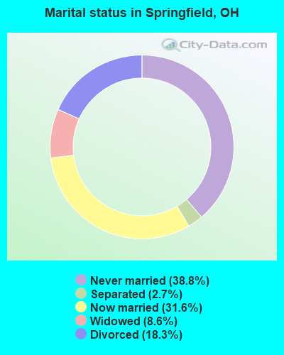
- Never married: 38.8%
- Now married: 31.6%
- Separated: 2.7%
- Widowed: 8.6%
- Divorced: 18.3%
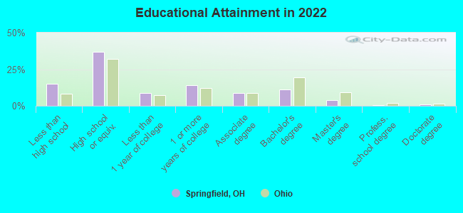
For population 25 years and over in Springfield:
- High school or higher: 85.7%
- Bachelor's degree or higher: 14.6%
- Graduate or professional degree: 4.5%
- Unemployed: 5.7%
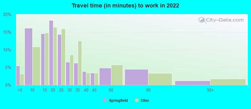
- Mean travel time to work (commute): 17.9 minutes
| Here: | 10.9 |
| Ohio average: | 11.0 |
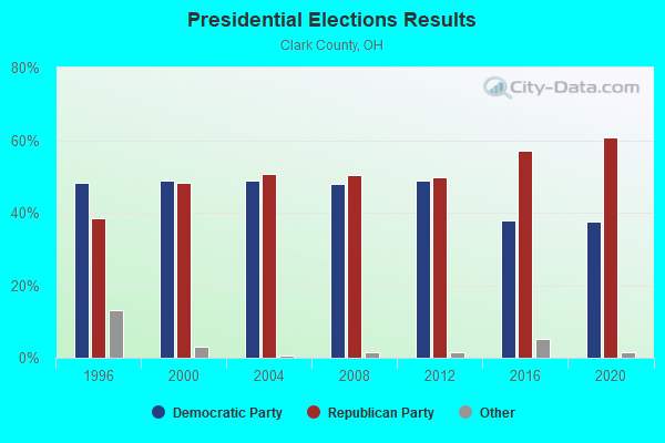
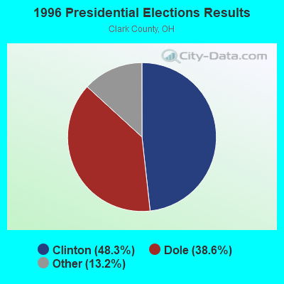

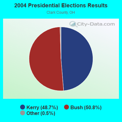
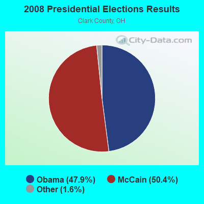
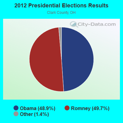
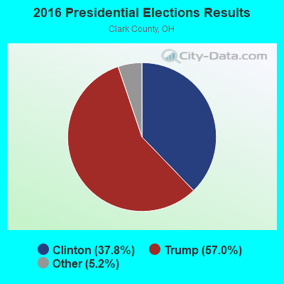
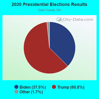
Graphs represent county-level data. Detailed 2008 Election Results
Religion statistics for Springfield, OH (based on Clark County data)
| Religion | Adherents | Congregations |
|---|---|---|
| Evangelical Protestant | 18,482 | 109 |
| Mainline Protestant | 12,863 | 52 |
| Catholic | 9,130 | 6 |
| Other | 1,508 | 8 |
| Black Protestant | 1,281 | 8 |
| Orthodox | 225 | 1 |
| None | 94,844 | - |
Food Environment Statistics:
| This county: | 1.57 / 10,000 pop. |
| Ohio: | 1.89 / 10,000 pop. |
| Clark County: | 0.07 / 10,000 pop. |
| Ohio: | 0.13 / 10,000 pop. |
| Clark County: | 1.43 / 10,000 pop. |
| Ohio: | 1.25 / 10,000 pop. |
| Here: | 2.85 / 10,000 pop. |
| State: | 2.93 / 10,000 pop. |
| Clark County: | 2.99 / 10,000 pop. |
| State: | 6.25 / 10,000 pop. |
| Here: | 11.4% |
| Ohio: | 10.3% |
| Clark County: | 30.0% |
| Ohio: | 29.1% |
| This county: | 11.8% |
| Ohio: | 11.9% |
Health and Nutrition:
| Springfield: | 48.2% |
| Ohio: | 50.4% |
| This city: | 44.1% |
| State: | 47.8% |
| Springfield: | 29.0 |
| Ohio: | 28.7 |
| This city: | 20.7% |
| State: | 20.6% |
| Springfield: | 12.6% |
| Ohio: | 10.4% |
| This city: | 6.8 |
| Ohio: | 6.8 |
| Here: | 34.0% |
| State: | 34.3% |
| Here: | 54.3% |
| Ohio: | 57.0% |
| This city: | 78.2% |
| Ohio: | 79.1% |
More about Health and Nutrition of Springfield, OH Residents
| Local government employment and payroll (March 2022) | |||||
| Function | Full-time employees | Monthly full-time payroll | Average yearly full-time wage | Part-time employees | Monthly part-time payroll |
|---|---|---|---|---|---|
| Firefighters | 132 | $828,506 | $75,319 | 0 | $0 |
| Police Protection - Officers | 124 | $781,681 | $75,647 | 0 | $0 |
| Judicial and Legal | 62 | $316,158 | $61,192 | 6 | $9,296 |
| Water Supply | 39 | $180,349 | $55,492 | 1 | $2,064 |
| Sewerage | 39 | $180,566 | $55,559 | 0 | $0 |
| Streets and Highways | 36 | $183,803 | $61,268 | 0 | $0 |
| Financial Administration | 31 | $172,911 | $66,933 | 4 | $7,883 |
| Other Government Administration | 21 | $117,583 | $67,190 | 3 | $7,163 |
| Parks and Recreation | 20 | $86,047 | $51,628 | 9 | $8,131 |
| Housing and Community Development (Local) | 14 | $74,641 | $63,978 | 0 | $0 |
| Police - Other | 14 | $49,425 | $42,364 | 0 | $0 |
| Natural Resources | 8 | $41,458 | $62,187 | 2 | $2,400 |
| Airports | 3 | $15,553 | $62,212 | 0 | $0 |
| Fire - Other | 1 | $4,703 | $56,436 | 1 | $394 |
| Other and Unallocable | 0 | $0 | 1 | $2,197 | |
| Totals for Government | 544 | $3,033,385 | $66,913 | 27 | $39,527 |
Springfield government finances - Expenditure in 2021 (per resident):
- Construction - Sewerage: $6,139,000 ($105.65)
Regular Highways: $5,245,000 ($90.27)
General - Other: $4,760,000 ($81.92)
Water Utilities: $640,000 ($11.01)
Housing and Community Development: $385,000 ($6.63)
- Current Operations - Police Protection: $28,604,000 ($492.27)
Sewerage: $10,544,000 ($181.46)
Local Fire Protection: $8,183,000 ($140.83)
General - Other: $7,755,000 ($133.46)
Water Utilities: $6,460,000 ($111.18)
Judicial and Legal Services: $5,975,000 ($102.83)
Housing and Community Development: $5,581,000 ($96.05)
Regular Highways: $4,962,000 ($85.40)
Transit Utilities: $3,767,000 ($64.83)
Financial Administration: $2,146,000 ($36.93)
Central Staff Services: $1,140,000 ($19.62)
Air Transportation: $971,000 ($16.71)
Parks and Recreation: $769,000 ($13.23)
Corrections - Other: $353,000 ($6.08)
Health - Other: $110,000 ($1.89)
- General - Interest on Debt: $2,327,000 ($40.05)
- Intergovernmental to State - Sewerage: $1,733,000 ($29.82)
- Other Capital Outlay - Transit Utilities: $706,000 ($12.15)
Judicial and Legal Services: $256,000 ($4.41)
General - Other: $195,000 ($3.36)
Police Protection: $88,000 ($1.51)
Local Fire Protection: $87,000 ($1.50)
Water Utilities: $85,000 ($1.46)
Central Staff Services: $62,000 ($1.07)
Air Transportation: $4,000 ($0.07)
- Total Salaries and Wages: $50,532,000 ($869.65)
- Water Utilities - Interest on Debt: $200,000 ($3.44)
Springfield government finances - Revenue in 2021 (per resident):
- Charges - Other: $3,298,000 ($56.76)
Sewerage: $1,998,000 ($34.39)
Regular Highways: $289,000 ($4.97)
Air Transportation: $126,000 ($2.17)
- Federal Intergovernmental - Housing and Community Development: $2,066,000 ($35.56)
Transit Utilities: $1,639,000 ($28.21)
Air Transportation: $364,000 ($6.26)
Other: $85,000 ($1.46)
- Miscellaneous - General Revenue - Other: $7,551,000 ($129.95)
Fines and Forfeits: $1,988,000 ($34.21)
Special Assessments: $371,000 ($6.38)
Interest Earnings: $307,000 ($5.28)
Sale of Property: $33,000 ($0.57)
- Revenue - Water Utilities: $6,886,000 ($118.51)
- State Intergovernmental - Highways: $7,617,000 ($131.09)
Other: $3,124,000 ($53.76)
General Local Government Support: $2,927,000 ($50.37)
Sewerage: $1,518,000 ($26.12)
Housing and Community Development: $711,000 ($12.24)
Transit Utilities: $21,000 ($0.36)
- Tax - Individual Income: $35,124,000 ($604.48)
Property: $2,199,000 ($37.84)
Other Selective Sales: $1,516,000 ($26.09)
Other License: $742,000 ($12.77)
Springfield government finances - Debt in 2021 (per resident):
- Long Term Debt - Beginning Outstanding - Unspecified Public Purpose: $33,730,000 ($580.49)
Outstanding Unspecified Public Purpose: $30,527,000 ($525.37)
Retired Unspecified Public Purpose: $3,203,000 ($55.12)
Springfield government finances - Cash and Securities in 2021 (per resident):
- Bond Funds - Cash and Securities: $1,844,000 ($31.74)
- Other Funds - Cash and Securities: $64,062,000 ($1102.50)
- Sinking Funds - Cash and Securities: $1,756,000 ($30.22)
| Businesses in Springfield, OH | ||||
| Name | Count | Name | Count | |
|---|---|---|---|---|
| AT&T | 2 | Lane Bryant | 1 | |
| Ace Hardware | 1 | Lane Furniture | 2 | |
| Advance Auto Parts | 3 | LensCrafters | 1 | |
| Aeropostale | 1 | Little Caesars Pizza | 3 | |
| American Eagle Outfitters | 1 | Long John Silver's | 3 | |
| Applebee's | 1 | Lowe's | 1 | |
| Arby's | 3 | Macy's | 1 | |
| Ashley Furniture | 1 | Marriott | 2 | |
| AutoZone | 2 | Marshalls | 1 | |
| Bath & Body Works | 1 | MasterBrand Cabinets | 5 | |
| Bed Bath & Beyond | 1 | McDonald's | 5 | |
| Blockbuster | 1 | Meijer | 1 | |
| Buffalo Wild Wings | 2 | Motherhood Maternity | 1 | |
| Burger King | 2 | Nike | 7 | |
| CVS | 3 | OfficeMax | 1 | |
| Carson Pirie Scott | 1 | Old Navy | 1 | |
| Catherines | 1 | Olive Garden | 1 | |
| Charlotte Russe | 1 | Pac Sun | 1 | |
| Chipotle | 1 | Panera Bread | 1 | |
| Chuck E. Cheese's | 1 | Papa John's Pizza | 2 | |
| Cold Stone Creamery | 1 | Payless | 2 | |
| Comfort Suites | 1 | Penske | 2 | |
| Cracker Barrel | 1 | PetSmart | 1 | |
| Cricket Wireless | 4 | Pizza Hut | 3 | |
| Curves | 2 | Quality | 1 | |
| DHL | 1 | RadioShack | 2 | |
| Dairy Queen | 3 | Ramada | 1 | |
| Days Inn | 1 | Red Lobster | 1 | |
| Deb | 1 | Red Roof Inn | 1 | |
| Domino's Pizza | 4 | Rite Aid | 2 | |
| Famous Footwear | 1 | Rue21 | 1 | |
| FedEx | 7 | SONIC Drive-In | 1 | |
| Finish Line | 1 | Sears | 2 | |
| Firestone Complete Auto Care | 1 | Spencer Gifts | 1 | |
| Foot Locker | 1 | Sprint Nextel | 2 | |
| GNC | 1 | Steak 'n Shake | 1 | |
| GameStop | 2 | Subway | 4 | |
| Goodwill | 3 | Super 8 | 1 | |
| H&R Block | 4 | T-Mobile | 3 | |
| Hardee's | 1 | T.G.I. Driday's | 1 | |
| Hilton | 1 | Taco Bell | 4 | |
| Hobby Lobby | 1 | Target | 1 | |
| Home Depot | 1 | Tim Hortons | 2 | |
| Honda | 1 | Toys"R"Us | 1 | |
| Hot Topic | 1 | U-Haul | 4 | |
| Hyundai | 1 | UPS | 15 | |
| JCPenney | 1 | Vans | 2 | |
| Jones New York | 1 | Verizon Wireless | 1 | |
| Journeys | 1 | Victoria's Secret | 1 | |
| KFC | 3 | Volkswagen | 1 | |
| Kincaid | 1 | Walgreens | 3 | |
| Kmart | 2 | Walmart | 2 | |
| Knights Inn | 1 | Wendy's | 4 | |
| Kohl's | 1 | White Castle | 1 | |
| Kroger | 5 | YMCA | 1 | |
| La-Z-Boy | 1 | |||
Strongest AM radio stations in Springfield:
- WIZE (1340 AM; 1 kW; SPRINGFIELD, OH; Owner: CITICASTERS LICENSES, L.P.)
- WULM (1600 AM; 1 kW; SPRINGFIELD, OH; Owner: URBAN LIGHT MINISTRIES, INC.)
- WLW (700 AM; 50 kW; CINCINNATI, OH; Owner: JACOR BROADCASTING CORPORATION)
- WTVN (610 AM; 50 kW; COLUMBUS, OH; Owner: CITICASTERS LICENSES, L.P.)
- WRFD (880 AM; daytime; 23 kW; COLUMBUS-WORTHINGTON, OH; Owner: SALEM MEDIA OF OHIO, INC.)
- WONE (980 AM; 5 kW; DAYTON, OH; Owner: CITICASTERS LICENSES, L.P.)
- WHIO (1290 AM; 5 kW; DAYTON, OH; Owner: CXR HOLDINGS, INC.)
- WGNZ (1110 AM; daytime; 2 kW; FAIRBORN, OH; Owner: L&D BROADCASTORS INC.)
- WSAI (1530 AM; 50 kW; CINCINNATI, OH; Owner: JACOR BROADCASTING CORPORATION)
- WING (1410 AM; 5 kW; DAYTON, OH)
- WOSU (820 AM; 5 kW; COLUMBUS, OH; Owner: THE OHIO STATE UNIVERSITY)
- WOWO (1190 AM; 50 kW; FORT WAYNE, IN; Owner: PATHFINDER COMMUNICATIONS CORPORATION)
- WHAS (840 AM; 50 kW; LOUISVILLE, KY; Owner: CLEAR CHANNEL BROADCASTING LICENSES, INC.)
Strongest FM radio stations in Springfield:
- WUSO (89.1 FM; SPRINGFIELD, OH; Owner: THE BD. OF DIR. OF WITTENBERG COLLEGE)
- WDHT (102.9 FM; SPRINGFIELD, OH; Owner: BLUE CHIP BROADCASTING LICENSES, LTD)
- WEEC (100.7 FM; SPRINGFIELD, OH; Owner: WORLD EVENGELISTIC ENTERPRISE CORP.)
- WRVT (88.7 FM; RUTLAND, VT; Owner: VERMONT PUBLIC RADIO)
- WKSW (101.7 FM; URBANA, OH; Owner: BLUE CHIP BROADCASTING LICENSES, LTD)
- WYSO (91.3 FM; YELLOW SPRINGS, OH; Owner: ANTIOCH UNIVERSITY)
- WHKO (99.1 FM; DAYTON, OH; Owner: CXR HOLDINGS, INC.)
- WCDR-FM (90.3 FM; CEDARVILLE, OH; Owner: THE CEDARVILLE UNIVERSITY)
- WLQT (99.9 FM; KETTERING, OH; Owner: CITICASTERS LICENSES, L.P.)
- WMMX (107.7 FM; DAYTON, OH; Owner: CITICASTERS LICENSES, L.P.)
- WTUE (104.7 FM; DAYTON, OH; Owner: CITICASTERS LICENSES, L.P.)
- WCSU-FM (88.9 FM; WILBERFORCE, OH; Owner: CENTRAL STATE UNIVERSITY)
- WXEG (103.9 FM; BEAVERCREEK, OH; Owner: CITICASTERS LICENSES, L.P.)
- WRNB (92.1 FM; WEST CARROLLTON, OH; Owner: RADIO ONE OF DAYTON LICENSES, LLC)
- W201AK (88.1 FM; COLUMBUS, OH; Owner: THE CEDARVILLE UNIVERSITY)
- WOSU-FM (89.7 FM; COLUMBUS, OH; Owner: THE OHIO STATE UNIVERSITY)
- WJYD (106.3 FM; LONDON, OH; Owner: BLUE CHIP BROADCASTING LICENSES, LTD)
- WZLR (95.3 FM; XENIA, OH; Owner: CXR HOLDINGS, INC.)
- WQRP (89.5 FM; DAYTON, OH; Owner: WQRP FAMILY RADIO, INC.)
- WOKL (96.9 FM; TROY, OH; Owner: EDUCATIONAL MEDIA FOUNDATION)
TV broadcast stations around Springfield:
- WBDT (Channel 26; SPRINGFIELD, OH; Owner: ACME TV LICENSES OF OHIO, LLC)
- W47BC (Channel 47; SPRINGFIELD, OH; Owner: TRINITY BROADCASTING NETWORK)
- WHIO-TV (Channel 7; DAYTON, OH; Owner: WHIO-TV HOLDINGS, INC.)
- WDTN (Channel 2; DAYTON, OH; Owner: WDTN BROADCASTING, LLC)
- WPTD (Channel 16; DAYTON, OH; Owner: GREATER DAYTON PUBLIC TV, INC.)
- WKEF (Channel 22; DAYTON, OH; Owner: WKEF LICENSEE L.P.)
- WRGT-TV (Channel 45; DAYTON, OH; Owner: WRGT LICENSEE, LLC)
- W61DE (Channel 61; CINCINNATI, OH; Owner: TRINITY BROADCASTING NETWORK)
- WWHO (Channel 53; CHILLICOTHE, OH; Owner: UPN STATIONS GROUP INC.)
- WSYX (Channel 6; COLUMBUS, OH; Owner: WSYX LICENSEE, INC.)
- WBNS-TV (Channel 10; COLUMBUS, OH; Owner: WBNS-TV, INC.)
- WTTE (Channel 28; COLUMBUS, OH; Owner: COLUMBUS (WTTE-TV) LICENSEE, INC.)
- WCMH-TV (Channel 4; COLUMBUS, OH; Owner: OUTLET BROADCASTING, INC.)
- WRCX-LP (Channel 51; DAYTON, OH; Owner: ROSS COMMUNICATIONS, LTD.)
Medal of Honor Recipients
Medal of Honor Recipients born in Springfield: Frederick Funston, James Richard Ward, John H. Ricksecker.
- National Bridge Inventory (NBI) Statistics
- 192Number of bridges
- 2,293ft / 699mTotal length
- $173,387,000Total costs
- 2,264,616Total average daily traffic
- 379,967Total average daily truck traffic
- New bridges - historical statistics
- 51900-1909
- 11910-1919
- 31920-1929
- 31930-1939
- 31940-1949
- 211950-1959
- 621960-1969
- 361970-1979
- 41980-1989
- 141990-1999
- 132000-2009
- 152010-2019
- 122020-2022
FCC Registered Antenna Towers: 517 (See the full list of FCC Registered Antenna Towers)
FCC Registered Commercial Land Mobile Towers: 2 (See the full list of FCC Registered Commercial Land Mobile Towers in Springfield, OH)
FCC Registered Private Land Mobile Towers: 14 (See the full list of FCC Registered Private Land Mobile Towers)
FCC Registered Broadcast Land Mobile Towers: 88 (See the full list of FCC Registered Broadcast Land Mobile Towers)
FCC Registered Microwave Towers: 38 (See the full list of FCC Registered Microwave Towers in this town)
FCC Registered Paging Towers: 21 (See the full list of FCC Registered Paging Towers)
FCC Registered Maritime Coast & Aviation Ground Towers: 5 (See the full list of FCC Registered Maritime Coast & Aviation Ground Towers)
FCC Registered Amateur Radio Licenses: 472 (See the full list of FCC Registered Amateur Radio Licenses in Springfield)
FAA Registered Aircraft: 59 (See the full list of FAA Registered Aircraft in Springfield)
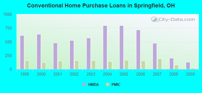
| Home Mortgage Disclosure Act Aggregated Statistics For Year 2009 (Based on 15 full and 9 partial tracts) | ||||||||||||||
| A) FHA, FSA/RHS & VA Home Purchase Loans | B) Conventional Home Purchase Loans | C) Refinancings | D) Home Improvement Loans | E) Loans on Dwellings For 5+ Families | F) Non-occupant Loans on < 5 Family Dwellings (A B C & D) | G) Loans On Manufactured Home Dwelling (A B C & D) | ||||||||
|---|---|---|---|---|---|---|---|---|---|---|---|---|---|---|
| Number | Average Value | Number | Average Value | Number | Average Value | Number | Average Value | Number | Average Value | Number | Average Value | Number | Average Value | |
| LOANS ORIGINATED | 204 | $81,571 | 129 | $80,198 | 501 | $95,720 | 58 | $17,728 | 1 | $909,340 | 81 | $66,372 | 1 | $73,000 |
| APPLICATIONS APPROVED, NOT ACCEPTED | 11 | $65,292 | 5 | $103,942 | 61 | $86,241 | 10 | $16,388 | 0 | $0 | 3 | $41,880 | 0 | $0 |
| APPLICATIONS DENIED | 32 | $76,737 | 35 | $67,697 | 290 | $81,850 | 62 | $17,634 | 0 | $0 | 35 | $44,263 | 4 | $37,478 |
| APPLICATIONS WITHDRAWN | 21 | $76,096 | 11 | $131,900 | 135 | $101,463 | 7 | $17,166 | 0 | $0 | 9 | $43,302 | 1 | $74,000 |
| FILES CLOSED FOR INCOMPLETENESS | 6 | $64,233 | 1 | $76,290 | 18 | $110,586 | 2 | $18,865 | 0 | $0 | 2 | $105,500 | 0 | $0 |
Detailed mortgage data for all 24 tracts in Springfield, OH
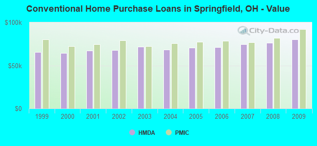
| Private Mortgage Insurance Companies Aggregated Statistics For Year 2009 (Based on 10 full and 8 partial tracts) | ||||||
| A) Conventional Home Purchase Loans | B) Refinancings | C) Non-occupant Loans on < 5 Family Dwellings (A & B) | ||||
|---|---|---|---|---|---|---|
| Number | Average Value | Number | Average Value | Number | Average Value | |
| LOANS ORIGINATED | 24 | $92,029 | 15 | $144,161 | 0 | $0 |
| APPLICATIONS APPROVED, NOT ACCEPTED | 8 | $84,631 | 10 | $105,910 | 1 | $97,700 |
| APPLICATIONS DENIED | 4 | $57,275 | 1 | $139,020 | 0 | $0 |
| APPLICATIONS WITHDRAWN | 1 | $115,800 | 1 | $86,920 | 0 | $0 |
| FILES CLOSED FOR INCOMPLETENESS | 1 | $152,260 | 2 | $109,480 | 0 | $0 |
2002 - 2018 National Fire Incident Reporting System (NFIRS) incidents
- Fire incident types reported to NFIRS in Springfield, OH
- 4,30245.8%Structure Fires
- 3,19134.0%Outside Fires
- 1,85119.7%Mobile Property/Vehicle Fires
- 540.6%Other
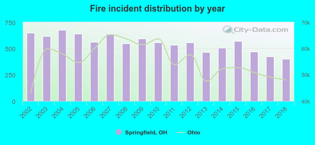 Based on the data from the years 2002 - 2018 the average number of fires per year is 553. The highest number of reported fire incidents - 678 took place in 2004, and the least - 399 in 2018. The data has a decreasing trend.
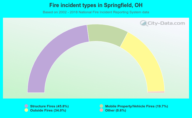 When looking into fire subcategories, the most incidents belonged to: Structure Fires (45.8%), and Outside Fires (34.0%).
Fire-safe hotels and motels in Springfield, Ohio:
- Drake Motel, 3200 E Main St, Springfield, Ohio 45505 , Phone: (937) 325-7334
- Rodeway Inn, 1715 W North St, Springfield, Ohio 45504 , Phone: (937) 324-5561, Fax: (937) 324-5845
- Howard Johnson, 11 W Leffel Ln, Springfield, Ohio 45506 , Phone: (937) 322-4941
- Ramada LTD, 319 E Leffel Ln, Springfield, Ohio 45505 , Phone: (937) 328-0123, Fax: (937) 322-4434
- Holiday Inn Springfield South, 383 E Leffel Ln, Springfield, Ohio 45505 , Phone: (937) 323-8631, Fax: (937) 323-5389
- Courtyard By Marriott Springfield Downtown, 100 S Fountain Ave, Springfield, Ohio 45502 , Phone: (973) 322-3600, Fax: (937) 322-0462
- Hampton Inn, 101 W Leffel Ln, Springfield, Ohio 45506 , Phone: (937) 325-8480, Fax: (937) 325-8634
- Red Roof Inn, 155 W Leffel Ln, Springfield, Ohio 45506 , Phone: (937) 325-5356, Fax: (937) 322-9409
- 4 other hotels and motels
| Most common first names in Springfield, OH among deceased individuals | ||
| Name | Count | Lived (average) |
|---|---|---|
| Mary | 1,324 | 79.6 years |
| John | 1,184 | 74.9 years |
| William | 1,065 | 74.8 years |
| Robert | 1,053 | 72.5 years |
| James | 874 | 71.8 years |
| Charles | 874 | 75.4 years |
| Helen | 594 | 80.3 years |
| George | 542 | 76.3 years |
| Dorothy | 473 | 79.5 years |
| Ruth | 459 | 80.6 years |
| Most common last names in Springfield, OH among deceased individuals | ||
| Last name | Count | Lived (average) |
|---|---|---|
| Smith | 521 | 75.8 years |
| Miller | 381 | 76.9 years |
| Johnson | 299 | 75.5 years |
| Jones | 269 | 75.3 years |
| Davis | 260 | 74.9 years |
| Brown | 250 | 73.9 years |
| Williams | 227 | 74.5 years |
| Wilson | 189 | 75.8 years |
| Baker | 164 | 77.3 years |
| Thompson | 153 | 77.9 years |
- 91.8%Utility gas
- 6.4%Electricity
- 0.9%Bottled, tank, or LP gas
- 0.4%Fuel oil, kerosene, etc.
- 0.4%Wood
- 0.1%Other fuel

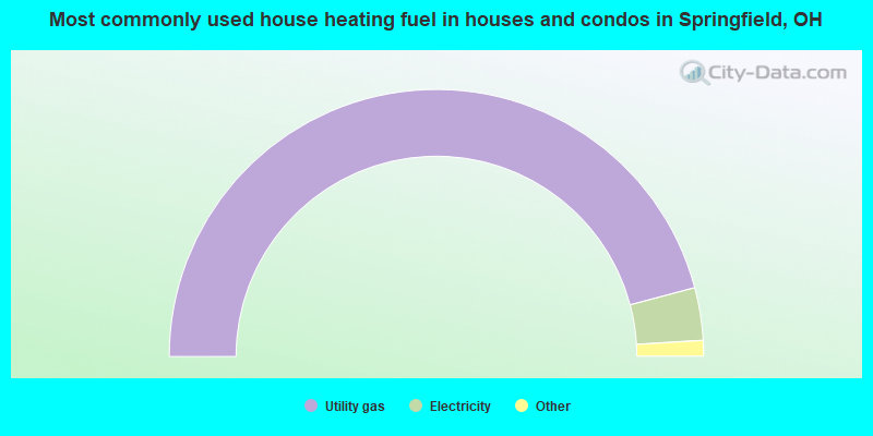
- 71.8%Utility gas
- 26.1%Electricity
- 1.1%Bottled, tank, or LP gas
- 0.6%No fuel used
- 0.3%Other fuel
Springfield compared to Ohio state average:
- Median household income below state average.
- Median house value below state average.
- Unemployed percentage below state average.
- Median age below state average.
- Foreign-born population percentage below state average.
- House age above state average.
- Percentage of population with a bachelor's degree or higher below state average.
Springfield on our top lists:
- #6 on the list of "Top 101 cities with the highest number of arson incidents per 100,000 residents, excludes tourist destinations and others with a lot of outsiders visiting based on city industries data (population 50,000+)"
- #6 on the list of "Top 101 cities with the highest average snowfall in a year (population 50,000+)"
- #10 on the list of "Top 101 cities with the highest number of burglaries per 100,000 residents, excludes tourist destinations and others with a lot of outsiders visiting based on city industries data (population 50,000+)"
- #13 on the list of "Top 101 cities with the most people born in the same U.S. state as the city (population 50,000+)"
- #16 on the list of "Top 101 cities with the largest percentage population decrease from 2000 (population 50,000+)"
- #19 on the list of "Top 100 cities with declining populations from 2000 to 2014 (pop. 50,000+)"
- #19 on the list of "Top 101 cities with the highest number of thefts per 100,000 residents, excludes tourist destinations and others with a lot of outsiders visiting based on city industries data (population 50,000+)"
- #23 on the list of "Top 101 cities with largest percentage population decreases in the 1990s) (population 50,000+)"
- #28 on the list of "Top 101 cities with largest percentage of females in industries: health care and social assistance (population 50,000+)"
- #31 on the list of "Top 101 cities with largest percentage of males in occupations: production occupations (population 50,000+)"
- #31 on the list of "Top 101 cities with the largest wind speed differences during a year (population 50,000+)"
- #34 on the list of "Top 100 least-safe cities (highest city-data.com crime index) (pop. 50,000+)"
- #39 on the list of "Top 101 larger cities with the largest decrease or smallest increase in household income from 2000 (population 50,000+)"
- #46 on the list of "Top 100 cities with oldest houses (pop. 50,000+)"
- #49 on the list of "Top 101 larger cities with the largest decrease or smallest increase in house/condo value from 2000 (population 50,000+)"
- #50 on the list of "Top 101 cities with largest percentage of males in occupations: building and grounds cleaning and maintenance occupations (population 50,000+)"
- #51 on the list of "Top 101 cities with largest percentage of males in occupations: community and social service occupations (population 50,000+)"
- #51 on the list of "Top 101 cities with the highest percentage of English-only speaking households, population 50,000+"
- #54 on the list of "Top 101 cities with the highest city-data.com crime index, excludes tourist destinations and others with a lot of outsiders visiting based on city industries data (population 50,000+)"
- #55 on the list of "Top 101 cities with the largest percentage of unmarried partner households (population 50,000+)"
- #38 on the list of "Top 101 counties with the highest Sulfur Oxides Annual air pollution readings in 2012 (µg/m3)"
- #56 on the list of "Top 101 counties with the lowest percentage of residents relocating from foreign countries between 2010 and 2011"
- #64 on the list of "Top 101 counties with the highest number of deaths per 1000 residents 2007-2013 (pop. 50,000+)"
- #80 on the list of "Top 101 counties with the lowest percentage of residents relocating from other counties between 2010 and 2011 (pop. 50,000+)"
- #93 on the list of "Top 101 counties with the largest number of people moving out compared to moving in (pop. 50,000+)"

|
|
Total of 148 patent applications in 2008-2024.