Southeast Washita, Oklahoma
Submit your own pictures of this place and show them to the world
- OSM Map
- General Map
- Google Map
- MSN Map

| Males: 418 | |
| Females: 424 |
| Median resident age: | 42.8 years |
| Oklahoma median age: | 35.5 years |
Zip code: 73632
| Southeast Washita: | $62,604 |
| OK: | $59,673 |
Estimated per capita income in 2022: $34,272 (it was $17,297 in 2000)
Southeast Washita CCD income, earnings, and wages data
Estimated median house or condo value in 2022: $150,501 (it was $56,100 in 2000)
| Southeast Washita: | $150,501 |
| OK: | $191,700 |
Mean prices in 2022: all housing units: $161,130; detached houses: $158,904; townhouses or other attached units: $68,005; mobile homes: $220,205
Southeast Washita, OK residents, houses, and apartments details
Detailed information about poverty and poor residents in Southeast Washita, OK
Compare current foreclosures near Southeast Washita, OK:
| Photo | Address | Area | Beds / Baths | Price | Details |
|---|---|---|---|---|---|

|
#1
Norma Rd
Hydro, OK 73048
|
1,782 sq. feet
|
2 baths 3 beds |
show details | |

|
#2
S Bruce St
Carnegie, OK 73015
|
2,778 sq. feet
|
2 baths 3 beds |
show details | |

|
#3
E 3rd St
Cordell, OK 73632
|
2,493 sq. feet
|
1 baths 3 beds |
show details | |

|
#4
N College St
Cordell, OK 73632
|
2,407 sq. feet
|
2 baths 3 beds |
show details | |

|
#5
Crestview Dr
Cordell, OK 73632
|
2,290 sq. feet
|
3 baths 4 beds |
show details | |

|
#6
Bluestem St
Weatherford, OK 73096
|
1,404 sq. feet
|
2 baths 3 beds |
show details | |

|
#7
N Oklahoma
Corn, OK 73024
|
- sq. feet
|
- baths - beds |
show details | |

|
#8
N 2270 Rd
Cordell, OK 73632
|
- sq. feet
|
- baths - beds |
show details | |

|
#9
10th St
Bessie, OK 73622
|
- sq. feet
|
- baths - beds |
show details | |

|
#10
N Oklahoma
Corn, OK 73024
|
- sq. feet
|
- baths - beds |
show details |
| Photo | Address | Area | Beds / Baths | Price | Details |
|---|---|---|---|---|---|

|
Check over 1 million property listings on Foreclosure.com!
|
browse all offers | |||
| Photo | Address | Area | Beds / Baths | Price | Details |
|---|

- 73988.7%White alone
- 506.0%American Indian alone
- 263.1%Hispanic
- 131.6%Two or more races
- 30.4%Black alone
- 10.1%Asian alone
- 10.1%Other race alone

Races in Southeast Washita detailed stats: ancestries, foreign born residents, place of birth
 Recent articles from our blog. Our writers, many of them Ph.D. graduates or candidates, create easy-to-read articles on a wide variety of topics.
Current Local Time: CST time zone
Land area: 252.7 square miles.
Population density: 3.3 people per square mile (very low).

| Southeast Washita CCD: | 0.5% ($284) |
| Oklahoma: | 0.8% ($523) |
Nearest city with pop. 50,000+: Lawton, OK  (48.6 miles , pop. 92,757).
Nearest city with pop. 200,000+: Oklahoma City, OK (69.2 miles , pop. 506,132).
Nearest city with pop. 1,000,000+: Dallas, TX (203.6 miles , pop. 1,188,580).
Nearest cities:
), ), Latitude: 35.26 N, Longitude: 98.73 W


| Here: | 3.3% |
| Oklahoma: | 3.2% |

- Agriculture, forestry, fishing & hunting (18.8%)
- Educational services (14.7%)
- Health care (12.6%)
- Mining, quarrying, oil & gas extraction (5.2%)
- Construction (5.2%)
- Public administration (4.4%)
- Truck transportation (4.1%)

- Agriculture, forestry, fishing & hunting (26.0%)
- Mining, quarrying, oil & gas extraction (8.8%)
- Construction (8.8%)
- Truck transportation (7.0%)
- Farm product raw materials merchant wholesalers (6.6%)
- Educational services (5.3%)
- Public administration (4.0%)

- Educational services (28.0%)
- Health care (26.1%)
- Agriculture, forestry, fishing & hunting (8.7%)
- Department & other general merchandise stores (5.6%)
- Public administration (5.0%)
- Accommodation & food services (5.0%)
- Finance & insurance (4.3%)

- Farmers and farm managers (14.4%)
- Driver/sales workers and truck drivers (8.8%)
- Preschool, kindergarten, elementary, and middle school teachers (7.0%)
- Health technologists and technicians (3.9%)
- Other teachers, instructors, education, training, and library occupations (3.4%)
- Registered nurses (3.1%)
- Extraction workers (3.1%)

- Farmers and farm managers (22.0%)
- Driver/sales workers and truck drivers (15.0%)
- Extraction workers (5.3%)
- Construction traders workers except carpenters, electricians, painters, plumbers, and construction laborers (4.4%)
- Metal workers and plastic workers (4.0%)
- Laborers and material movers, hand (4.0%)
- Other management occupations, except farmers and farm managers (3.5%)

- Preschool, kindergarten, elementary, and middle school teachers (13.0%)
- Registered nurses (7.5%)
- Nursing, psychiatric, and home health aides (6.8%)
- Health technologists and technicians (6.2%)
- Material recording, scheduling, dispatching, and distributing workers (6.2%)
- Other teachers, instructors, education, training, and library occupations (5.6%)
- Financial managers (4.3%)
Average climate in Southeast Washita, Oklahoma
Based on data reported by over 4,000 weather stations


(lower is better)

Air Quality Index (AQI) level in 2019 was 43.8. This is significantly better than average.
| City: | 43.8 |
| U.S.: | 72.6 |

Particulate Matter (PM10) [µg/m3] level in 2019 was 17.5. This is about average. Closest monitor was 20.7 miles away from the city center.
| City: | 17.5 |
| U.S.: | 19.2 |
Tornado activity:
Southeast Washita-area historical tornado activity is near Oklahoma state average. It is 174% greater than the overall U.S. average.
On 5/25/1962, a category F4 (max. wind speeds 207-260 mph) tornado 19.8 miles away from the Southeast Washita place center injured 9 people and caused between $50,000 and $500,000 in damages.
On 5/22/1981, a category F4 tornado 20.8 miles away from the place center caused between $500,000 and $5,000,000 in damages.
Earthquake activity:
Southeast Washita-area historical earthquake activity is significantly above Oklahoma state average. It is 756% greater than the overall U.S. average.On 9/3/2016 at 12:02:44, a magnitude 5.8 (5.8 MW, Depth: 3.5 mi, Class: Moderate, Intensity: VI - VII) earthquake occurred 129.1 miles away from Southeast Washita center
On 11/6/2011 at 03:53:10, a magnitude 5.7 (5.7 MW, Depth: 3.2 mi) earthquake occurred 112.5 miles away from the city center
On 2/13/2016 at 17:07:06, a magnitude 5.1 (5.1 MW, Depth: 5.2 mi) earthquake occurred 84.9 miles away from the city center
On 11/7/2016 at 01:44:24, a magnitude 5.0 (5.0 MW, Depth: 2.8 mi) earthquake occurred 119.6 miles away from the city center
On 6/16/1978 at 11:46:54, a magnitude 5.3 (4.4 MB, 4.6 UK, 5.3 ML) earthquake occurred 193.4 miles away from the city center
On 1/7/2016 at 04:27:57, a magnitude 4.7 (4.7 MW, Depth: 2.5 mi, Class: Light, Intensity: IV - V) earthquake occurred 85.2 miles away from the city center
Magnitude types: body-wave magnitude (MB), local magnitude (ML), moment magnitude (MW)
Natural disasters:
The number of natural disasters in Washita County (29) is a lot greater than the US average (15).Major Disasters (Presidential) Declared: 21
Emergencies Declared: 5
Causes of natural disasters: Floods: 16, Storms: 13, Winter Storms: 11, Tornadoes: 9, Ice Storms: 2, Winds: 2, Hurricane: 1, Snowstorm: 1, Other: 1 (Note: some incidents may be assigned to more than one category).
Hospitals and medical centers near Southeast Washita:
- CORN HERITAGE VILLAGE (Nursing Home, about 9 miles away; CORN, OK)
- MENNONITE BRETHREN HOME FOR AGED (Nursing Home, about 9 miles away; CORN, OK)
- MT VIEW HEALTH CARE, INC (Nursing Home, about 12 miles away; MOUNTAIN VIEW, OK)
- CARNEGIE HOME HEALTH (Home Health Center, about 13 miles away; CARNEGIE, OK)
- CARNEGIE TRI-COUNTY MUNICIPAL HOSPITAL Critical Access Hospitals (about 13 miles away; CARNEGIE, OK)
- CARNEGIE NURSING HOME, INC. (Nursing Home, about 14 miles away; CARNEGIE, OK)
- CORDELL CARE CENTER (Nursing Home, about 14 miles away; CORDELL, OK)
Colleges/universities with over 2000 students nearest to Southeast Washita:
- Southwestern Oklahoma State University (about 19 miles; Weatherford, OK; Full-time enrollment: 4,126)
- Cameron University (about 49 miles; Lawton, OK; FT enrollment: 4,695)
- Western Oklahoma State College (about 54 miles; Altus, OK; FT enrollment: 2,054)
- Southern Nazarene University (about 65 miles; Bethany, OK; FT enrollment: 2,064)
- Mid-America Christian University (about 66 miles; Oklahoma City, OK; FT enrollment: 2,869)
- Oklahoma City Community College (about 67 miles; Oklahoma City, OK; FT enrollment: 8,904)
- Oklahoma State University-Oklahoma City (about 67 miles; Oklahoma City, OK; FT enrollment: 4,784)
Points of interest:
Notable location: Colony Fire Department (A). Display/hide its location on the map
Churches in Southeast Washita include: Colony Baptist Church (A), Odessa Church (B), Salem Church (C), Sappington Chapel (D), Sharon Church (E), New Harmony Church (F), Plainview Church (G), Mount Vernon Church (H). Display/hide their locations on the map
Cemeteries: Plainview Cemetery (1), Salem Cemetery (2), Odessa Cemetery (3), Fesser Cemetery (4), Bethany Cemetery (5), High Point Cemetery (6), Indian Cemetery (7). Display/hide their locations on the map
Lakes and reservoirs: Lake Vanderwork (A), Crowder Lake (B), Worth Richmond Lake (C), Ionine Creek Site 102 Reservoir (D), Cowden Laterals Site 4 Reservoir (E), Cavalry Creek Site 1 Reservoir (F), Cavalry Creek Site 2 Reservoir (G), Cowden Laterals Site 3 Reservoir (H). Display/hide their locations on the map
Creeks: Bull Creek (A), Two Baby Creek (B), Taylor Creek (C), Cavalry Creek (D), Oak Creek (E), Friendship Creek (F). Display/hide their locations on the map
Park in Southeast Washita: Crowder Lake State Recreation Area (1). Display/hide its location on the map
| This place: | 2.5 people |
| Oklahoma: | 2.5 people |
| This place: | 70.7% |
| Whole state: | 66.8% |
| This place: | 6.7% |
| Whole state: | 5.9% |
Likely homosexual households (counted as self-reported same-sex unmarried-partner households)
- Lesbian couples: 0.6% of all households
- Gay men: 0.0% of all households
| This place: | 15.9% |
| Whole state: | 14.7% |
| This place: | 8.0% |
| Whole state: | 6.1% |
For population 15 years and over in Southeast Washita:

- Never married: 14.5%
- Now married: 70.7%
- Separated: 1.4%
- Widowed: 7.8%
- Divorced: 7.0%
For population 25 years and over in Southeast Washita:
- High school or higher: 81.7%
- Bachelor's degree or higher: 15.3%
- Graduate or professional degree: 5.0%
- Unemployed: 6.7%
- Mean travel time to work (commute): 19.6 minutes


| Here: | 9.7 |
| Oklahoma average: | 11.7 |
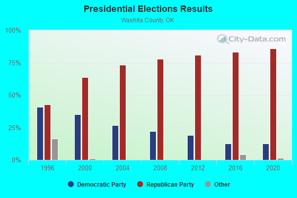
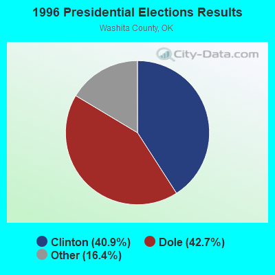
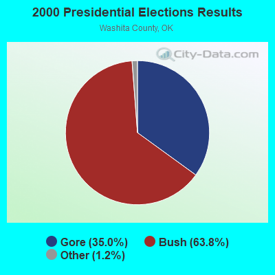
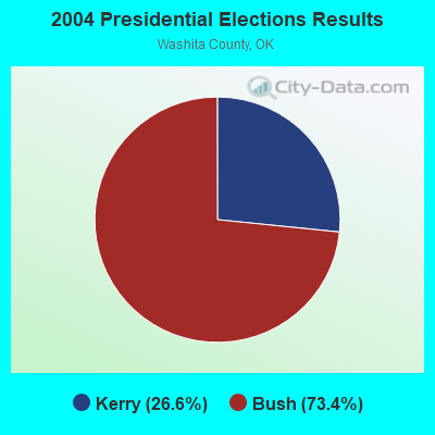
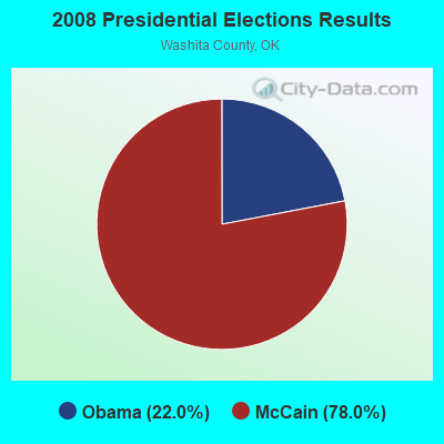
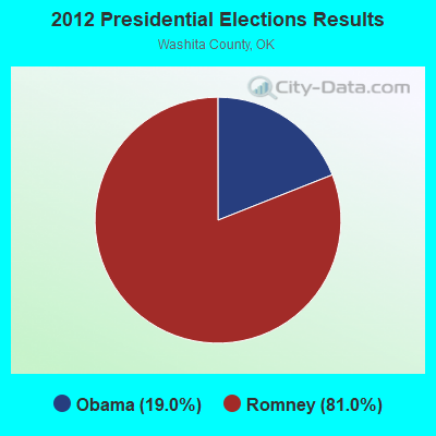
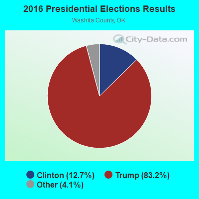
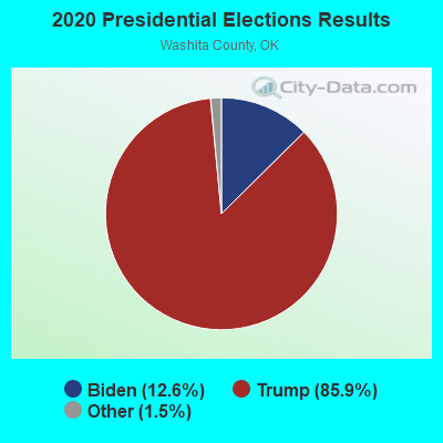
Graphs represent county-level data. Detailed 2008 Election Results
Religion statistics for Southeast Washita, OK (based on Washita County data)
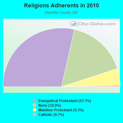
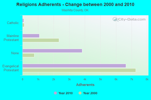
| Religion | Adherents | Congregations |
|---|---|---|
| Evangelical Protestant | 6,641 | 31 |
| Mainline Protestant | 1,084 | 7 |
| Catholic | 81 | 1 |
| None | 3,823 | - |
Food Environment Statistics:
| Washita County: | 1.72 / 10,000 pop. |
| Oklahoma: | 1.97 / 10,000 pop. |
| This county: | 1.72 / 10,000 pop. |
| Oklahoma: | 0.76 / 10,000 pop. |
| Washita County: | 6.87 / 10,000 pop. |
| State: | 4.35 / 10,000 pop. |
| Washita County: | 8.58 / 10,000 pop. |
| Oklahoma: | 6.89 / 10,000 pop. |
| Washita County: | 10.5% |
| Oklahoma: | 10.3% |
| Here: | 26.1% |
| Oklahoma: | 29.2% |
Strongest AM radio stations in Southeast Washita:
- KJON (850 AM; daytime; 5 kW; ANADARKO, OK; Owner: CARROLLTON BROADCASTING OF TEXAS, LP)
- KOMA (1520 AM; 50 kW; OKLAHOMA CITY, OK; Owner: RENDA BROADCASTING CORP. OF NEVADA)
- KRMG (740 AM; 50 kW; TULSA, OK; Owner: CXR HOLDINGS, INC.)
- KCLI (1320 AM; 1 kW; CLINTON, OK; Owner: WRIGHT BROADCASTING SYSTEMS, INC.)
- KWEY (1590 AM; 1 kW; WEATHERFORD, OK; Owner: WRIGHT BROADCASTING SYSTEMS, INC.)
- WWLS (640 AM; 5 kW; MOORE, OK; Owner: CITADEL BROADCASTING COMPANY)
- WBAP (820 AM; 50 kW; FORT WORTH, TX; Owner: WBAP-KSCS OPERATING, LTD.)
- KFAQ (1170 AM; 50 kW; TULSA, OK; Owner: JOURNAL BROADCAST CORPORATION)
- KGYN (1210 AM; 50 kW; GUYMON, OK; Owner: TELNS BROADCASTING COMPANY, INC.)
- KCAF (990 AM; 10 kW; FARMERSVILLE, TX; Owner: RENAISSANCE RADIO, INC.)
- KRLD (1080 AM; 50 kW; DALLAS, TX; Owner: TEXAS INFINITY BROADCASTING L.P.)
- KTJS (1420 AM; 1 kW; HOBART, OK; Owner: FUCHS RADIO, LLC)
- KAHZ (1360 AM; 50 kW; HURST, TX)
Strongest FM radio stations in Southeast Washita:
- KRMP (103.5 FM; ANADARKO, OK; Owner: PERRY BROADCASTING OF SOUTHWEST OKLAHOMA, INC.)
- KWEY-FM (97.3 FM; WEATHERFORD, OK; Owner: WRIGHT BROADCASTING SYSTEMS, INC.)
- KQMX (95.5 FM; CLINTON, OK; Owner: WRIGHT BROADCASTING SYSTEMS, INC)
- KCDL (99.3 FM; CORDELL, OK; Owner: WRIGHT BROADCASTING SYSTEMS, INC.)
- KYCU (89.1 FM; CLINTON, OK; Owner: CAMERON UNIVERSITY)
- KTIJ (98.5 FM; ELK CITY, OK; Owner: FUCHS RADIO, LLC)
- KQTZ (105.9 FM; HOBART, OK; Owner: ALTUS RADIO, INC.)
- KAYM (90.5 FM; WEATHERFORD, OK; Owner: AMERICAN FAMILY ASSOCIATION)
- K216FR (91.1 FM; CLINTON, OK; Owner: CALVARY CHAPEL OF TWIN FALLS, INC.)
TV broadcast stations around Southeast Washita:
- KWTV (Channel 9; OKLAHOMA CITY, OK; Owner: GRIFFIN ENTITIES, L.L.C.)
- K17DH (Channel 17; WEATHERFORD, OK; Owner: NORTHFORK TV TRANSLATOR SYSTEM)
- K20DX (Channel 20; WEATHERFORD, OK; Owner: NORTHFORK TV TRANSLATOR SYSTEM)
- K22ED (Channel 22; WEATHERFORD, OK; Owner: NORTHFORK TV TRANSLATOR SYSTEM)
- K41DS (Channel 41; WEATHERFORD, OK; Owner: NORTHFORK TV TRANSLATOR SYSTEM)
- K59GE (Channel 39; WEATHERFORD, OK; Owner: NORTHFORK TV TRANSLATOR SYSTEM)

- 40.1%Electricity
- 34.2%Bottled, tank, or LP gas
- 23.0%Utility gas
- 1.5%Other fuel
- 1.1%Wood

- 44.3%Bottled, tank, or LP gas
- 36.7%Utility gas
- 13.9%Electricity
- 5.1%Wood
Southeast Washita compared to Oklahoma state average:
- Unemployed percentage below state average.
- Black race population percentage significantly below state average.
- Hispanic race population percentage significantly below state average.
- Median age above state average.
- Foreign-born population percentage significantly below state average.
- Length of stay since moving in significantly above state average.
- Number of rooms per house significantly below state average.
- House age significantly below state average.