Southeast Benton, Oregon
Southeast Benton: Young Trees.....
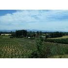
Southeast Benton: Farm,,,,,
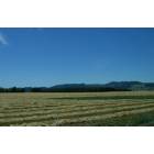
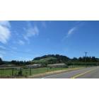
Southeast Benton: Blue Sky...
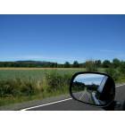
Southeast Benton: In the Mirror....
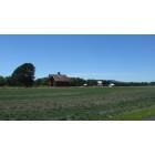
Southeast Benton: Rural Home...

Southeast Benton: Gravel Road.....
- add
your
Submit your own pictures of this place and show them to the world
- OSM Map
- General Map
- Google Map
- MSN Map

| Males: 1,972 | |
| Females: 1,868 |
| Median resident age: | 39.2 years |
| Oregon median age: | 36.3 years |
Zip code: 97456
| Southeast Benton: | $71,555 |
| OR: | $75,657 |
Estimated per capita income in 2022: $40,739 (it was $22,705 in 2000)
Southeast Benton CCD income, earnings, and wages data
Estimated median house or condo value in 2022: $505,376 (it was $161,600 in 2000)
| Southeast Benton: | $505,376 |
| OR: | $475,600 |
Mean prices in 2022: all housing units: $527,422; detached houses: $564,307; townhouses or other attached units: $409,548; in 2-unit structures: $301,079; in 3-to-4-unit structures: $485,522; in 5-or-more-unit structures: $256,840; mobile homes: $179,405; occupied boats, rvs, vans, etc.: $76,136
Southeast Benton, OR residents, houses, and apartments details
Detailed information about poverty and poor residents in Southeast Benton, OR
Compare current foreclosures near Southeast Benton, OR:
| Photo | Address | Area | Beds / Baths | Price | Details |
|---|---|---|---|---|---|

|
#1
Orchard Tract Rd
Monroe, OR 97456
|
1,056 sq. feet
|
2 baths 3 beds |
show details | |

|
#2
Toftdahl Rd
Junction City, OR 97448
|
1,712 sq. feet
|
2 baths 4 beds |
show details | |

|
#3
Elm St
Junction City, OR 97448
|
- sq. feet
|
2 baths 3 beds |
show details | |

|
#4
Smith St
Harrisburg, OR 97446
|
1,084 sq. feet
|
2 baths 3 beds |
show details | |

|
#5
Highway 99e
Tangent, OR 97389
|
- sq. feet
|
1 baths 4 beds |
show details | |

|
#6
NW Huckleberry Dr
Corvallis, OR 97330
|
1,567 sq. feet
|
2 baths 3 beds |
show details | |

|
#7
NW Sequoia Ave
Corvallis, OR 97330
|
1,562 sq. feet
|
2 baths 3 beds |
show details | |

|
#8
NW 29th St
Corvallis, OR 97330
|
1,584 sq. feet
|
1 baths 4 beds |
show details | |

|
#9
NW Crest Dr
Corvallis, OR 97330
|
2,317 sq. feet
|
3 baths 4 beds |
show details | |

|
#10
W 6th Ave
Junction City, OR 97448
|
2,049 sq. feet
|
2 baths 4 beds |
show details |
| Photo | Address | Area | Beds / Baths | Price | Details |
|---|---|---|---|---|---|

|
#11
NW 29th St
Corvallis, OR 97330
|
988 sq. feet
|
2 baths 2 beds |
show details | |

|
#12
Crona St
Junction City, OR 97448
|
1,024 sq. feet
|
1 baths 3 beds |
show details | |

|
#13
Deal St
Junction City, OR 97448
|
1,024 sq. feet
|
1 baths 3 beds |
show details | |

|
#14
Laurel St
Junction City, OR 97448
|
3,294 sq. feet
|
2 baths 3 beds |
show details | |

|
#15
N Lake Creek Dr Unit 57
Tangent, OR 97389
|
1,782 sq. feet
|
2 baths 3 beds |
show details | |

|
#16
Deal St
Junction City, OR 97448
|
1,576 sq. feet
|
2 baths 4 beds |
show details | |

|
#17
NE Cambridge Cir
Corvallis, OR 97330
|
1,488 sq. feet
|
2 baths 3 beds |
show details | |

|
#18
Kalmia St
Junction City, OR 97448
|
1,050 sq. feet
|
1 baths 2 beds |
show details | |

|
#19
W 10th Ave
Junction City, OR 97448
|
1,100 sq. feet
|
1 baths 2 beds |
show details | |

|
#20
NE Highway 20
Corvallis, OR 97330
|
1,082 sq. feet
|
1 baths 2 beds |
show details |
| Photo | Address | Area | Beds / Baths | Price | Details |
|---|---|---|---|---|---|

|
#21
S 2nd St
Harrisburg, OR 97446
|
1,834 sq. feet
|
2 baths 4 beds |
show details | |

|
#22
Cartney Dr
Harrisburg, OR 97446
|
1,792 sq. feet
|
2 baths 3 beds |
show details | |

|
#23
S 24th St
Philomath, OR 97370
|
1,040 sq. feet
|
1 baths 3 beds |
show details | |

|
#24
N 6th St
Harrisburg, OR 97446
|
1,564 sq. feet
|
2 baths 3 beds |
show details | |

|
#25
Oakview Dr
Corvallis, OR 97333
|
1,104 sq. feet
|
2 baths 3 beds |
show details | |

|
#26
Highway 99w
Corvallis, OR 97333
|
1,604 sq. feet
|
1 baths 2 beds |
show details | |

|
#27
SW 53rd St
Corvallis, OR 97333
|
924 sq. feet
|
1 baths - beds |
show details | |

|
#28
College St
Philomath, OR 97370
|
- sq. feet
|
- baths - beds |
show details | |

|
#29
River Rd
Junction City, OR 97448
|
- sq. feet
|
- baths - beds |
show details | |

|
#30
NW Elmwood Pl
Corvallis, OR 97330
|
- sq. feet
|
- baths - beds |
show details |
| Photo | Address | Area | Beds / Baths | Price | Details |
|---|---|---|---|---|---|

|
#31
NW Circle Blvd
Corvallis, OR 97330
|
- sq. feet
|
- baths - beds |
show details | |

|
#32
NW Walnut Blvd
Corvallis, OR 97330
|
- sq. feet
|
- baths - beds |
show details | |

|
#33
NW Stardown Dr
Corvallis, OR 97330
|
- sq. feet
|
- baths - beds |
show details | |

|
#34
Jaeg Rd
Junction City, OR 97448
|
- sq. feet
|
- baths - beds |
show details | |

|
#35
Erica Pl
Harrisburg, OR 97446
|
- sq. feet
|
- baths - beds |
show details | |

|
#36
NW Garryanna Dr Apt 3
Corvallis, OR 97330
|
- sq. feet
|
- baths - beds |
show details | |

|
#37
NW Garryanna Dr
Corvallis, OR 97330
|
- sq. feet
|
- baths - beds |
show details | |

|
#38
NE 2nd St Apt 19
Corvallis, OR 97330
|
- sq. feet
|
- baths - beds |
show details | |

|
#39
N Lake Creek Dr Unit 72
Tangent, OR 97389
|
- sq. feet
|
1 baths - beds |
show details | |

|
#40
NE Conifer Blvd Apt C
Corvallis, OR 97330
|
- sq. feet
|
- baths - beds |
show details |
| Photo | Address | Area | Beds / Baths | Price | Details |
|---|---|---|---|---|---|

|
#41
NE Oxford Cir Apt B
Corvallis, OR 97330
|
- sq. feet
|
- baths - beds |
show details | |

|
#42
River Rd
Junction City, OR 97448
|
- sq. feet
|
- baths - beds |
show details | |

|
#43
NW 25th St
Corvallis, OR 97330
|
- sq. feet
|
- baths - beds |
show details | |

|
#44
Lasalle St Apt 4
Harrisburg, OR 97446
|
- sq. feet
|
- baths - beds |
show details | |

|
#45
NW Fillmore Ave # 3
Corvallis, OR 97330
|
- sq. feet
|
- baths - beds |
show details | |

|
#46
SW Wake Robin Ave
Corvallis, OR 97333
|
- sq. feet
|
- baths - beds |
show details | |

|
#47
Oakville Rd SW # 44
Albany, OR 97321
|
- sq. feet
|
- baths - beds |
show details | |

|
#48
W 10th Ave, Apt 130
Junction City, OR 97448
|
- sq. feet
|
- baths - beds |
show details | |

|
#49
Timothy Pl
Junction City, OR 97448
|
- sq. feet
|
- baths - beds |
show details | |

|
Check over 1 million property listings on Foreclosure.com!
|
browse all offers | |||

- 3,35791.2%White alone
- 1885.1%Hispanic
- 742.0%Two or more races
- 280.8%American Indian alone
- 180.5%Asian alone
- 70.2%Black alone
- 60.2%Native Hawaiian and Other
Pacific Islander alone - 30.08%Other race alone

Races in Southeast Benton detailed stats: ancestries, foreign born residents, place of birth
 Recent articles from our blog. Our writers, many of them Ph.D. graduates or candidates, create easy-to-read articles on a wide variety of topics.
Current Local Time: PST time zone
Land area: 165.6 square miles.
Population density: 23 people per square mile (very low).

| Southeast Benton CCD: | 0.7% ($1,182) |
| Oregon: | 1.2% ($1,687) |
Nearest city with pop. 50,000+: Eugene, OR  (24.3 miles , pop. 137,893).
Nearest city with pop. 200,000+: Northwest Clackamas, OR (79.0 miles , pop. 224,220).
Nearest city with pop. 1,000,000+: Los Angeles, CA (759.0 miles , pop. 3,694,820).
Nearest cities:
Latitude: 44.37 N, Longitude: 123.33 W
Area code commonly used in this area: 541


| Here: | 3.1% |
| Oregon: | 3.9% |

- Agriculture, forestry, fishing & hunting (16.3%)
- Educational services (12.5%)
- Health care (7.7%)
- Construction (7.0%)
- Wood products (4.8%)
- Professional, scientific, technical services (4.0%)
- Computer & electronic products (3.7%)

- Agriculture, forestry, fishing & hunting (22.5%)
- Construction (11.5%)
- Wood products (7.8%)
- Educational services (7.7%)
- Metal & metal products (4.8%)
- Computer & electronic products (4.7%)
- Transportation equipment (3.6%)

- Educational services (18.2%)
- Health care (13.7%)
- Agriculture, forestry, fishing & hunting (8.8%)
- Professional, scientific, technical services (6.3%)
- Accommodation & food services (5.7%)
- Food & beverage stores (5.0%)
- Personal & laundry services (4.4%)

- Farmers and farm managers (6.2%)
- Other production occupations, including supervisors (6.0%)
- Agricultural workers, including supervisors (5.3%)
- Other management occupations, except farmers and farm managers (4.0%)
- Driver/sales workers and truck drivers (3.0%)
- Secretaries and administrative assistants (2.8%)
- Bookkeeping, accounting, and auditing clerks (2.8%)

- Farmers and farm managers (9.1%)
- Other production occupations, including supervisors (8.6%)
- Agricultural workers, including supervisors (7.7%)
- Driver/sales workers and truck drivers (4.8%)
- Metal workers and plastic workers (4.3%)
- Other management occupations, except farmers and farm managers (4.1%)
- Construction traders workers except carpenters, electricians, painters, plumbers, and construction laborers (3.7%)

- Secretaries and administrative assistants (6.3%)
- Bookkeeping, accounting, and auditing clerks (6.2%)
- Registered nurses (5.2%)
- Other office and administrative support workers, including supervisors (4.9%)
- Other management occupations, except farmers and farm managers (3.9%)
- Other health diagnosing and treating practitioners and technical occupations (3.7%)
- Other teachers, instructors, education, training, and library occupations (3.4%)
Average climate in Southeast Benton, Oregon
Based on data reported by over 4,000 weather stations


(lower is better)

Air Quality Index (AQI) level in 2023 was 83.5. This is about average.
| City: | 83.5 |
| U.S.: | 72.6 |

Particulate Matter (PM10) [µg/m3] level in 2022 was 16.0. This is about average. Closest monitor was 11.9 miles away from the city center.
| City: | 16.0 |
| U.S.: | 19.2 |

Particulate Matter (PM2.5) [µg/m3] level in 2023 was 6.19. This is better than average. Closest monitor was 15.3 miles away from the city center.
| City: | 6.19 |
| U.S.: | 8.11 |
Earthquake activity:
Southeast Benton-area historical earthquake activity is significantly above Oregon state average. It is 2209% greater than the overall U.S. average.On 1/31/1922 at 13:17:28, a magnitude 7.6 (7.6 UK, Class: Major, Intensity: VIII - XII) earthquake occurred 278.1 miles away from the city center
On 11/8/1980 at 10:27:34, a magnitude 7.2 (6.2 MB, 7.2 MS, 7.2 MW, 7.0 ML) earthquake occurred 231.0 miles away from the city center
On 8/17/1991 at 22:17:14, a magnitude 7.1 (6.2 MB, 7.1 MS, 7.1 MW, 6.8 ML, Depth: 8.4 mi) earthquake occurred 214.4 miles away from the city center
On 4/13/1949 at 19:55:42, a magnitude 7.0 (7.0 UK) earthquake occurred 203.0 miles away from the city center, causing $80,000,000 total damage
On 6/15/2005 at 02:50:54, a magnitude 7.2 (7.2 MW, Depth: 9.9 mi) earthquake occurred 251.2 miles away from Southeast Benton center
On 6/15/2005 at 02:50:54, a magnitude 7.2 (6.1 MB, 7.1 MS, 7.2 MW, 7.1 MW) earthquake occurred 257.4 miles away from Southeast Benton center
Magnitude types: body-wave magnitude (MB), local magnitude (ML), surface-wave magnitude (MS), moment magnitude (MW)
Natural disasters:
The number of natural disasters in Benton County (12) is smaller than the US average (15).Major Disasters (Presidential) Declared: 10
Emergencies Declared: 1
Causes of natural disasters: Floods: 6, Storms: 4, Winter Storms: 4, Landslides: 2, Mudslides: 2, Winds: 2, Fire: 1, Heavy Rain: 1, Hurricane: 1, Snow: 1, Other: 1 (Note: some incidents may be assigned to more than one category).
Hospitals and medical centers near Southeast Benton:
- AVAMERE REHABILITATION OF JUNCTION CITY (Nursing Home, about 13 miles away; JUNCTION CITY, OR)
- GRANDVIEW MANOR CARE CENTER (Nursing Home, about 13 miles away; JUNCTION CITY, OR)
- SAMARITAN HEART OF THE VALLEY (Nursing Home, about 14 miles away; CORVALLIS, OR)
- CORVALLIS CARE CENTER (Nursing Home, about 16 miles away; CORVALLIS, OR)
Colleges/universities with over 2000 students nearest to Southeast Benton:
- Oregon State University (about 14 miles; Corvallis, OR; Full-time enrollment: 23,206)
- Linn-Benton Community College (about 19 miles; Albany, OR; FT enrollment: 4,511)
- University of Oregon (about 26 miles; Eugene, OR; FT enrollment: 23,329)
- Lane Community College (about 30 miles; Eugene, OR; FT enrollment: 6,373)
- Western Oregon University (about 34 miles; Monmouth, OR; FT enrollment: 5,131)
- Willamette University (about 42 miles; Salem, OR; FT enrollment: 2,551)
- Chemeketa Community College (about 46 miles; Salem, OR; FT enrollment: 10,746)
Points of interest:
Notable locations in Southeast Benton: Monroe Sewage Treatment Plant (A), Alpine County Service District Sewage Facility (B), Greenberry (C), Shrock (D), Bruce (E), Rickard (F), Buchanan (G), Booneville (H), Alpine Junction (I), Dawson (J), Stahlbush Island Farms (K), Irish Bend County Park Boat Launch (L), Harken's Lake Landing Boat Access (M), Bailey Junction (N), Bellfountain Junction (O), Territorial Road Orchard (P), Monroe Rural Fire Protection District Station 1 (Q), Monroe Rural Fire Protection District Station 3 (R), Monroe Rural Fire Protection District Station 2 (S), South Benton Communities Historical Association Museum (T). Display/hide their locations on the map
Churches in Southeast Benton include: Monroe Church of Christ (A), United Methodist Church (B). Display/hide their locations on the map
Cemeteries: Alpine Cemetery (1), Bellfountain Cemetery (2), Saint Rose Cemetery (3), Reeves Cemetery (4), Irwin Cemetery (5), Winkle Cemetery (6), Butte Cemetery (7). Display/hide their locations on the map
Lakes, reservoirs, and swamps: Harkens Lake (A), Martins Lake (B), McBee Lake (C), Oliver Lake (D), Porter Lake (E), Riser Lake (F), Whitaker Lake (G), Winkle Lake (H). Display/hide their locations on the map
Streams, rivers, and creeks: Muddy Creek (A), Perkins Slough (B), Blue Lake Slough (C), Fall Creek (D), Evergreen Creek (E), Booneville Slough (F), Brown Creek (G), Hull Creek (H), Rambo Creek (I). Display/hide their locations on the map
Parks in Southeast Benton include: Saxton County Park (1), William L Finley National Wildlife Refuge (2), Finley National Wildlife Refuge (3), Alsea Falls Recreation Site (4), Bellfountain County Park (5), Irish Bend County Park (6), Anderson County Park (7). Display/hide their locations on the map
| This place: | 2.5 people |
| Oregon: | 2.5 people |
| This place: | 72.0% |
| Whole state: | 63.4% |
| This place: | 7.0% |
| Whole state: | 8.0% |
Likely homosexual households (counted as self-reported same-sex unmarried-partner households)
- Lesbian couples: 0.5% of all households
- Gay men: 0.2% of all households
| This place: | 9.0% |
| Whole state: | 11.6% |
| This place: | 3.6% |
| Whole state: | 5.0% |
For population 15 years and over in Southeast Benton:

- Never married: 19.1%
- Now married: 69.2%
- Separated: 1.6%
- Widowed: 3.5%
- Divorced: 8.3%
For population 25 years and over in Southeast Benton:
- High school or higher: 87.8%
- Bachelor's degree or higher: 23.8%
- Graduate or professional degree: 9.9%
- Unemployed: 5.3%
- Mean travel time to work (commute): 25.3 minutes


| Here: | 11.0 |
| Oregon average: | 11.5 |
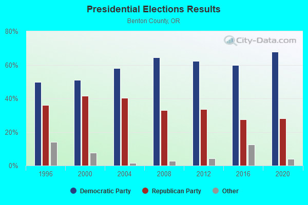
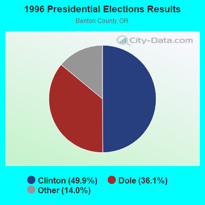
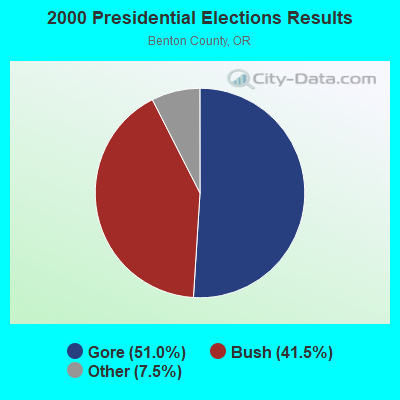
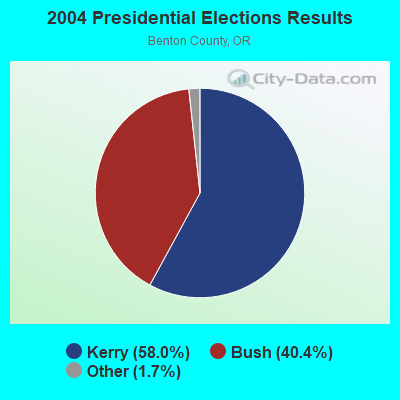
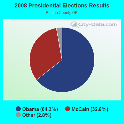
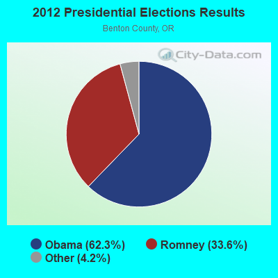
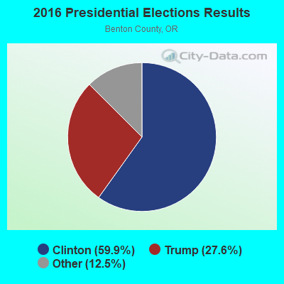
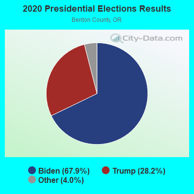
Graphs represent county-level data. Detailed 2008 Election Results
Religion statistics for Southeast Benton, OR (based on Benton County data)
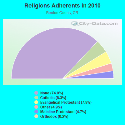
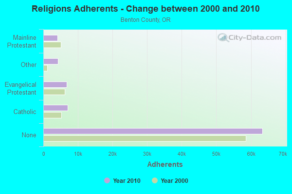
| Religion | Adherents | Congregations |
|---|---|---|
| Catholic | 7,077 | 2 |
| Evangelical Protestant | 6,758 | 50 |
| Other | 4,164 | 19 |
| Mainline Protestant | 4,065 | 11 |
| Orthodox | 160 | 2 |
| None | 63,355 | - |
Food Environment Statistics:
| Here: | 1.73 / 10,000 pop. |
| State: | 2.03 / 10,000 pop. |
| Benton County: | 0.37 / 10,000 pop. |
| Oregon: | 0.33 / 10,000 pop. |
| Benton County: | 1.60 / 10,000 pop. |
| Oregon: | 2.01 / 10,000 pop. |
| Here: | 1.48 / 10,000 pop. |
| Oregon: | 1.69 / 10,000 pop. |
| Benton County: | 7.15 / 10,000 pop. |
| Oregon: | 9.93 / 10,000 pop. |
| Benton County: | 6.0% |
| Oregon: | 7.4% |
| Benton County: | 22.0% |
| Oregon: | 25.6% |
| Here: | 16.9% |
| State: | 14.2% |
Strongest AM radio stations in Southeast Benton:
- KZTU (660 AM; 10 kW; JUNCTION CITY, OR; Owner: PAMPLIN BROADCASTING-OREGON, INC.)
- KPNW (1120 AM; 50 kW; EUGENE, OR; Owner: CAPSTAR TX LIMITED PARTNERSHIP)
- KOAC (550 AM; 5 kW; CORVALLIS, OR; Owner: OREGON PUBLIC BROADCASTING)
- KDUN (1030 AM; 50 kW; REEDSPORT, OR; Owner: PAMPLIN BROADCASTING-OREGON, INC.)
- KUGN (590 AM; 5 kW; EUGENE, OR; Owner: CUMULUS LICENSING CORP.)
- KPOJ (620 AM; 50 kW; PORTLAND, OR; Owner: CITICASTERS LICENSES, L.P.)
- KXL (750 AM; 50 kW; PORTLAND, OR; Owner: ROSE CITY RADIO CORPORATION)
- KRVM (1280 AM; 5 kW; EUGENE, OR; Owner: LANE COUNTY SCHOOL DISTRICT 4J)
- KORE (1050 AM; 5 kW; SPRINGFIELD-EUGENE, OR; Owner: SUPPORT CHRISTIAN BROADCASTING)
- KEX (1190 AM; 50 kW; PORTLAND, OR; Owner: CITICASTERS LICENSES, L.P.)
- KPAM (860 AM; 50 kW; TROUTDALE, OR; Owner: PAMPLIN BROADCASTING-OREGON, INC.)
- KOTK (1080 AM; 50 kW; PORTLAND, OR; Owner: FISHER BROADCASTING - PORTLAND RADIO, L.L.C.)
- KKSN (1520 AM; 50 kW; OREGON CITY, OR; Owner: ENTERCOM PORTLAND LICENSE, LLC)
Strongest FM radio stations in Southeast Benton:
- KDUK-FM (104.7 FM; FLORENCE, OR; Owner: CAPSTAR TX LIMITED PARTNERSHIP)
- KFLY (101.5 FM; CORVALLIS, OR; Owner: CITICASTERS LICENSES, L.P.)
- K207BX (89.3 FM; EUGENE, OR; Owner: PENSACOLA CHRISTIAN COLLEGE, INC.)
- K203BT (88.5 FM; EUGENE, OR; Owner: CALVARY CHAPEL OF TWIN FALLS, INC.)
- K214CI (90.7 FM; EUGENE, OR; Owner: EDUCATIONAL MEDIA FOUNDATION)
- KODZ (99.1 FM; EUGENE, OR; Owner: CAPSTAR TX LIMITED PARTNERSHIP)
- KHPE (107.9 FM; ALBANY, OR; Owner: INTEGRITY MEDIA, INC.)
- K264AA (100.7 FM; CORVALLIS, ETC., OR; Owner: THE KBOO FOUNDATION)
- KLOO-FM (106.3 FM; CORVALLIS, OR; Owner: CITICASTERS LICENSES, L.P.)
- KEHK (102.3 FM; BROWNSVILLE, OR; Owner: CUMULUS LICENSING CORP.)
- K276BU (103.1 FM; CORVALLIS, OR; Owner: OREGON PUBLIC BROADCASTING)
- K243AL (96.5 FM; CORVALLIS, OR; Owner: CUMULUS LICENSING CORP.)
- KRKT-FM (99.9 FM; ALBANY, OR; Owner: CITICASTERS LICENSES, L.P.)
- KLVU (107.1 FM; SWEET HOME, OR; Owner: EDUCATIONAL MEDIA FOUNDATION)
- KKNU (93.1 FM; SPRINGFIELD-EUGENE, OR; Owner: MCKENZIE RIVER BROADCASTING COMPANY, INC.)
- KMGE (94.5 FM; EUGENE, OR; Owner: MCKENZIE RIVER BROADCASTING COMPANY, INC.)
- KUJZ (95.3 FM; CRESWELL, OR; Owner: CUMULUS LICENSING CORP.)
- KXPC-FM (103.7 FM; LEBANON, OR; Owner: PORTLAND BROADCASTING, L.L.C.)
- KZEL-FM (96.1 FM; EUGENE, OR; Owner: CUMULUS LICENSING CORP.)
- KNRQ-FM (97.9 FM; EUGENE, OR; Owner: CUMULUS LICENSING CORP.)
TV broadcast stations around Southeast Benton:
- KLSR-TV (Channel 34; EUGENE, OR; Owner: CALIFORNIA OREGON BROADCASTING, INC.)
- KVAL-TV (Channel 13; EUGENE, OR; Owner: FISHER BROADCASTING - OREGON TV, L.L.C.)
- KEPB-TV (Channel 28; EUGENE, OR; Owner: OREGON PUBLIC BROADCASTING)
- KEVU-LP (Channel 23; EUGENE, OR; Owner: CALIFORNIA OREGON BROADCASTING, INC.)
- KMTR (Channel 16; EUGENE, OR; Owner: ACKERLEY MEDIA GROUP, INC.)
- KOAC-TV (Channel 7; CORVALLIS, OR; Owner: OREGON PUBLIC BROADCASTING)
- KEZI (Channel 9; EUGENE, OR; Owner: KEZI, INC.)
- K14GW (Channel 14; CORVALLIS, OR; Owner: CALIFORNIA OREGON BROADCASTING, INC.)

- 53.8%Electricity
- 25.0%Wood
- 9.8%Fuel oil, kerosene, etc.
- 6.4%Bottled, tank, or LP gas
- 4.3%Other fuel
- 0.6%Utility gas

- 56.6%Electricity
- 28.0%Wood
- 10.1%Fuel oil, kerosene, etc.
- 3.5%Other fuel
- 0.9%Utility gas
- 0.9%Bottled, tank, or LP gas
Southeast Benton compared to Oregon state average:
- Unemployed percentage below state average.
- Black race population percentage significantly below state average.
- Hispanic race population percentage below state average.
- Foreign-born population percentage significantly below state average.
- Length of stay since moving in significantly above state average.
- Number of rooms per house significantly below state average.
- House age significantly below state average.