South Valley, Montana
Submit your own pictures of this place and show them to the world
- OSM Map
- General Map
- Google Map
- MSN Map

| Males: 311 | |
| Females: 304 |
| Median resident age: | 44.9 years |
| Montana median age: | 37.5 years |
Zip code: 59230
| South Valley: | $75,293 |
| MT: | $67,631 |
Estimated per capita income in 2022: $33,408 (it was $17,316 in 2000)
South Valley CCD income, earnings, and wages data
Estimated median house or condo value in 2022: $327,510 (it was $88,300 in 2000)
| South Valley: | $327,510 |
| MT: | $366,400 |
Mean prices in 2022: all housing units: $219,157; detached houses: $216,231; townhouses or other attached units: $62,765; in 3-to-4-unit structures: $68,397; mobile homes: $281,248
Detailed information about poverty and poor residents in South Valley, MT


- 66997.8%White alone
- 101.5%Two or more races
- 50.7%American Indian alone

Races in South Valley detailed stats: ancestries, foreign born residents, place of birth
 Recent articles from our blog. Our writers, many of them Ph.D. graduates or candidates, create easy-to-read articles on a wide variety of topics.
Current Local Time: MST time zone
Land area: 1329.1 square miles.
Population density: 0.5 people per square mile (very low).

| South Valley CCD: | 0.9% ($800) |
| Montana: | 1.3% ($1,212) |
Nearest city with pop. 50,000+: Billings, MT  (172.1 miles , pop. 89,847).
Nearest city with pop. 200,000+: West Adams, CO (566.3 miles , pop. 259,628).
Nearest city with pop. 1,000,000+: Chicago, IL (1023.1 miles , pop. 2,896,016).
Nearest cities:
), ), )Latitude: 47.96 N, Longitude: 106.77 W
Area code commonly used in this area: 406


| Here: | 3.0% |
| Montana: | 3.8% |

- Agriculture, forestry, fishing & hunting (17.0%)
- Accommodation & food services (12.4%)
- Public administration (12.1%)
- Educational services (10.1%)
- Construction (8.1%)
- Health care (5.8%)
- Utilities (4.9%)

- Agriculture, forestry, fishing & hunting (27.3%)
- Public administration (15.3%)
- Construction (13.1%)
- Utilities (6.6%)
- Accommodation & food services (6.6%)
- Repair & maintenance (5.5%)
- Educational services (4.4%)

- Accommodation & food services (18.9%)
- Educational services (16.5%)
- Public administration (8.5%)
- Health care (8.5%)
- Social assistance (7.9%)
- Agriculture, forestry, fishing & hunting (5.5%)
- Real estate & rental & leasing (4.3%)

- Farmers and farm managers (10.4%)
- Building and grounds cleaning and maintenance occupations (6.9%)
- Preschool, kindergarten, elementary, and middle school teachers (6.6%)
- Vehicle and mobile equipment mechanics, installers, and repairers (4.9%)
- Agricultural workers, including supervisors (3.7%)
- Cooks and food preparation workers (3.5%)
- Other management occupations, except farmers and farm managers (3.5%)

- Farmers and farm managers (16.4%)
- Vehicle and mobile equipment mechanics, installers, and repairers (9.3%)
- Agricultural workers, including supervisors (7.1%)
- Law enforcement workers, including supervisors (4.9%)
- Building and grounds cleaning and maintenance occupations (4.9%)
- Other management occupations, except farmers and farm managers (4.4%)
- Life and physical scientists (4.4%)

- Preschool, kindergarten, elementary, and middle school teachers (11.6%)
- Building and grounds cleaning and maintenance occupations (9.1%)
- Waiters and waitresses (7.3%)
- Counselors, social workers, and other community and social service specialists (4.9%)
- Child care workers (4.3%)
- Bookkeeping, accounting, and auditing clerks (4.3%)
- Other office and administrative support workers, including supervisors (4.3%)
Average climate in South Valley, Montana
Based on data reported by over 4,000 weather stations


Earthquake activity:
South Valley-area historical earthquake activity is significantly above Montana state average. It is 296% greater than the overall U.S. average.On 8/18/1959 at 06:37:13, a magnitude 7.7 (7.7 UK, Class: Major, Intensity: VIII - XII) earthquake occurred 299.4 miles away from the city center, causing $26,000,000 total damage
On 10/28/1983 at 14:06:06, a magnitude 7.3 (6.2 MB, 7.3 MS, 7.0 MW) earthquake occurred 431.3 miles away from South Valley center, causing 2 deaths (2 shaking deaths) and 3 injuries, causing $15,000,000 total damage
On 6/30/1975 at 18:54:13, a magnitude 6.1 (5.6 MB, 5.9 MS, 6.1 UK, 6.1 ML, Class: Strong, Intensity: VII - IX) earthquake occurred 296.0 miles away from South Valley center
On 7/6/2017 at 06:30:17, a magnitude 5.8 (5.8 MW, Depth: 7.6 mi, Class: Moderate, Intensity: VI - VII) earthquake occurred 281.7 miles away from the city center
On 7/26/2005 at 04:08:37, a magnitude 5.7 (5.7 MB, 5.2 MS, 5.6 MW) earthquake occurred 327.5 miles away from South Valley center
On 3/31/2020 at 23:52:30, a magnitude 6.5 (6.5 MW, Depth: 7.5 mi) earthquake occurred 466.7 miles away from South Valley center
Magnitude types: body-wave magnitude (MB), local magnitude (ML), surface-wave magnitude (MS), moment magnitude (MW)
Natural disasters:
The number of natural disasters in Valley County (10) is smaller than the US average (15).Major Disasters (Presidential) Declared: 6
Emergencies Declared: 1
Causes of natural disasters: Floods: 8, Storms: 4, Heavy Rain: 1, Hurricane: 1, Landslide: 1, Snow: 1, Wind: 1, Other: 1 (Note: some incidents may be assigned to more than one category).
Colleges/universities with over 2000 students nearest to South Valley:
- Montana State University-Billings (about 172 miles; Billings, MT; Full-time enrollment: 4,319)
- Sheridan College (about 222 miles; Sheridan, WY; FT enrollment: 2,070)
- Minot State University (about 254 miles; Minot, ND; FT enrollment: 2,887)
- Montana State University (about 258 miles; Bozeman, MT; FT enrollment: 12,942)
- Black Hills State University (about 277 miles; Spearfish, SD; FT enrollment: 3,166)
- Bismarck State College (about 290 miles; Bismarck, ND; FT enrollment: 3,015)
- University of Mary (about 295 miles; Bismarck, ND; FT enrollment: 2,854)
Points of interest:
Notable locations in South Valley: Anderson Ranch (A), Archambeault Ranch (B), Magruder Ranch (C), Blanchard Cabin (D), Blanchard Ranch (E), Browning Ranch (F), Charles M Russell NWR Station (G), Collins Ranch (H), Engstrom Ranch (I), Etchart Cow Camp (J), Etchart Stone House (K), Faranuf Ranch (L), Gideon Ranch (M), Wittmayer Ranch (N), Handley Ranch (O), Harper Camp (P), Duck Creek Fishing Access Site (Q), Fort Peck Dredge Cuts Fishing Access Site (R), West End Campground (S), Stebley Ranch (T). Display/hide their locations on the map
Churches in South Valley include: Fort Peck Chapel (A), Galpin Church (B). Display/hide their locations on the map
Cemeteries: Fort Peck Cemetery (1), Galpin Cemetery (2). Display/hide their locations on the map
Lakes and reservoirs: Dry Lake (A), Jack Rabbit Reservoir (B), Itcaina Reservoir (C), Prairie Reservoir (D), Browning Reservoir (E), Bomber Reservoir (F), Your Name Reservoir (G), Blanchard Reservoir (H). Display/hide their locations on the map
Creeks: Beaver Creek (A), Carpenter Creek (B), Coyote Creek (C), Dog Creek (D), Dogie Creek (E), Hard Pan Creek (F), Little Brazil Creek (G), Lone Tree Creek (H), Mud Creek (I). Display/hide their locations on the map
Parks in South Valley include: Big Muddy Park (1), The Pines Recreation Area (2), Coleman Wildlife Park (3), Downstream Recreation Area (4), Trout Pond Recreation Area (5), Duck Creek Recreation Area (6), Fort Peck Recreation Area (7), Bone Trail Recreation Area (8), Charles M Russell National Wildlife Refuge (9). Display/hide their locations on the map
| This place: | 2.2 people |
| Montana: | 2.4 people |
| This place: | 69.9% |
| Whole state: | 62.8% |
| This place: | 5.0% |
| Whole state: | 6.7% |
Likely homosexual households (counted as self-reported same-sex unmarried-partner households)
- Lesbian couples: 1.3% of all households
- Gay men: 0.0% of all households
| This place: | 6.7% |
| Whole state: | 14.6% |
| This place: | 0.3% |
| Whole state: | 5.8% |
For population 15 years and over in South Valley:

- Never married: 15.4%
- Now married: 68.4%
- Separated: 0.3%
- Widowed: 7.0%
- Divorced: 9.3%
For population 25 years and over in South Valley:
- High school or higher: 86.1%
- Bachelor's degree or higher: 23.2%
- Graduate or professional degree: 6.3%
- Unemployed: 4.4%
- Mean travel time to work (commute): 15.7 minutes


| Here: | 10.4 |
| Montana average: | 10.4 |
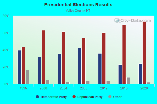
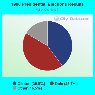
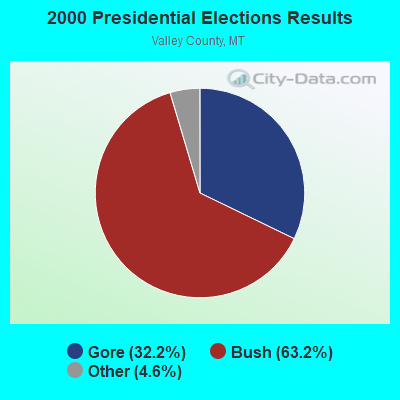

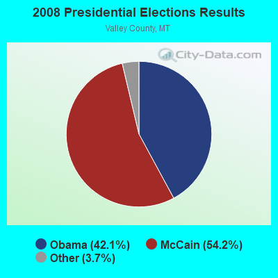

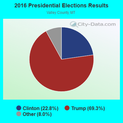
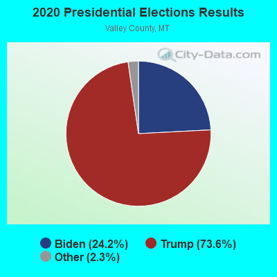
Graphs represent county-level data. Detailed 2008 Election Results
Religion statistics for South Valley, MT (based on Valley County data)
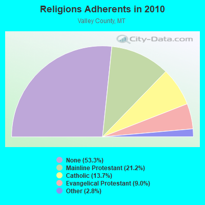
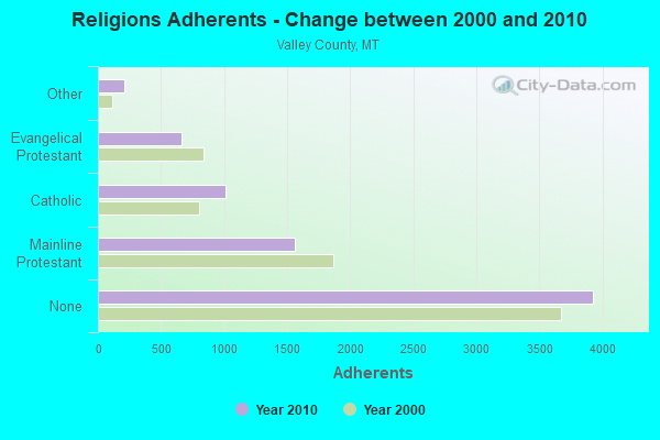
| Religion | Adherents | Congregations |
|---|---|---|
| Mainline Protestant | 1,562 | 11 |
| Catholic | 1,010 | 6 |
| Evangelical Protestant | 663 | 13 |
| Other | 205 | 3 |
| None | 3,929 | - |
Food Environment Statistics:
| Valley County: | 4.36 / 10,000 pop. |
| State: | 2.55 / 10,000 pop. |
| Valley County: | 5.81 / 10,000 pop. |
| Montana: | 4.69 / 10,000 pop. |
| Here: | 14.53 / 10,000 pop. |
| Montana: | 10.38 / 10,000 pop. |
| This county: | 8.8% |
| Montana: | 7.2% |
| Here: | 24.7% |
| State: | 23.1% |
| This county: | 14.9% |
| Montana: | 10.7% |
Strongest AM radio stations in South Valley:
- KLTZ (1240 AM; 1 kW; GLASGOW, MT; Owner: GLASGOW BROADCASTING CO.)
- KATL (770 AM; 10 kW; MILES CITY, MT; Owner: STAR PRINTING COMPANY)
- KXMR (710 AM; 50 kW; BISMARCK, ND; Owner: RADIO BISMARCK MANDAN, LLC)
- KMTA (1050 AM; 10 kW; MILES CITY, MT; Owner: SENGER BROADCASTING CORPORATION)
- KERR (750 AM; 50 kW; POLSON, MT; Owner: ANDERSON RADIO BROADCASTING, INC.)
- KTWO (1030 AM; 50 kW; CASPER, WY; Owner: CITICASTERS LICENSES, L.P.)
- KOFI (1180 AM; 50 kW; KALISPELL, MT; Owner: KOFI, INC.)
- KBHB (810 AM; 25 kW; STURGIS, SD; Owner: MONTEREY LICENSES, LLC)
- KATQ (1070 AM; daytime; 5 kW; PLENTYWOOD, MT; Owner: RADIO INTERNAT'L-KATQ B/CAST ASSOC.)
- KEYZ (660 AM; 5 kW; WILLISTON, ND; Owner: COMMONWEALTH LICENSE SUBSIDIARY, LLC)
- KIKC (1250 AM; 5 kW; FORSYTH, MT; Owner: MILES CITY, FORSYTH B/DCSTG, INC.)
- KVCK (1450 AM; 1 kW; WOLF POINT, MT; Owner: WOLF TOWN WIRELESS, INC.)
- KUYO (830 AM; daytime; 25 kW; EVANSVILLE, WY; Owner: WYOMING CHRISTIAN BROADCASTING COMPANY)
Strongest FM radio stations in South Valley:
- KLAN (93.5 FM; GLASGOW, MT; Owner: W.L. HOLTER/GLASGOW B/CASTG CO.)

- 36.6%Utility gas
- 36.6%Bottled, tank, or LP gas
- 18.5%Electricity
- 4.2%Wood
- 2.1%Other fuel
- 1.7%No fuel used
- 0.4%Fuel oil, kerosene, etc.

- 35.2%Bottled, tank, or LP gas
- 33.3%Utility gas
- 27.8%Electricity
- 3.7%Wood
South Valley compared to Montana state average:
- Unemployed percentage significantly below state average.
- Black race population percentage significantly below state average.
- Hispanic race population percentage significantly below state average.
- Median age above state average.
- Foreign-born population percentage significantly below state average.
- Renting percentage significantly below state average.
- Length of stay since moving in significantly above state average.
- Number of rooms per house significantly below state average.
- House age significantly below state average.
- Number of college students significantly below state average.
South Valley on our top lists:
- #99 on the list of "Top 100 cities with largest land areas"
- #79 on the list of "Top 101 counties with highest percentage of residents voting for 3rd party candidates in the 2012 Presidential Election"