South Le Flore, Oklahoma
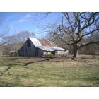
Submit your own pictures of this place and show them to the world
- OSM Map
- General Map
- Google Map
- MSN Map

| Males: 320 | |
| Females: 320 |
| Median resident age: | 41.1 years |
| Oklahoma median age: | 35.5 years |
Zip code: 74957
| South Le Flore: | $39,582 |
| OK: | $59,673 |
Estimated per capita income in 2022: $19,275 (it was $11,401 in 2000)
South Le Flore CCD income, earnings, and wages data
Estimated median house or condo value in 2022: $91,121 (it was $37,500 in 2000)
| South Le Flore: | $91,121 |
| OK: | $191,700 |
Mean prices in 2022: all housing units: $187,295; detached houses: $200,172; townhouses or other attached units: $325,325; mobile homes: $97,221; occupied boats, rvs, vans, etc.: $135,422
South Le Flore, OK residents, houses, and apartments details
Detailed information about poverty and poor residents in South Le Flore, OK
Compare current foreclosures near your location:
| Photo | Address | Area | Beds / Baths | Price | Details |
|---|---|---|---|---|---|

|
#1
Bayberry Cir
Columbus, OH 43207
|
1,564 sq. feet
|
1 baths 3 beds |
$127,500
|
show details |

|
#2
E 21st Ave
Columbus, OH 43211
|
1,061 sq. feet
|
1 baths 3 beds |
$179,900
|
show details |

|
#3
S High St
Columbus, OH 43207
|
1,678 sq. feet
|
2 baths 4 beds |
$27,500
|
show details |

|
#4
Inishmore Ln
Dublin, OH 43017
|
912 sq. feet
|
1 baths 1 beds |
show details | |

|
#5
Lewis Rd
Columbus, OH 43207
|
1,976 sq. feet
|
2 baths 4 beds |
show details | |

|
#6
Front St
Commercial Point, OH 43116
|
1,311 sq. feet
|
2 baths 3 beds |
show details | |

|
#7
Wallcrest Blvd
Columbus, OH 43231
|
2,152 sq. feet
|
3 baths 3 beds |
show details | |

|
#8
Hall Rd
Galloway, OH 43119
|
1,008 sq. feet
|
1 baths 3 beds |
show details | |

|
#9
Braeburn Ct
Blacklick, OH 43004
|
2,122 sq. feet
|
3 baths 4 beds |
show details | |

|
#10
Elm Ct
Westerville, OH 43082
|
2,022 sq. feet
|
3 baths 4 beds |
show details |
| Photo | Address | Area | Beds / Baths | Price | Details |
|---|---|---|---|---|---|

|
#11
Wallcrest Blvd
Columbus, OH 43231
|
2,236 sq. feet
|
3 baths 4 beds |
show details | |

|
#12
Ironstone Dr
Columbus, OH 43231
|
1,236 sq. feet
|
2 baths 3 beds |
show details | |

|
#13
Hardwood Dr
Galloway, OH 43119
|
2,435 sq. feet
|
3 baths 3 beds |
show details | |

|
#14
Heritage Lakes Dr
Hilliard, OH 43026
|
3,895 sq. feet
|
5 baths 4 beds |
show details | |

|
#15
Andrew Rd
Columbus, OH 43227
|
1,053 sq. feet
|
2 baths 3 beds |
show details | |

|
#16
Golden Cloud Ln
Columbus, OH 43228
|
1,576 sq. feet
|
3 baths 3 beds |
show details | |

|
#17
Alderson Ct
Columbus, OH 43228
|
1,224 sq. feet
|
3 baths 3 beds |
show details | |

|
#18
Doral Ave
Columbus, OH 43213
|
2,124 sq. feet
|
3 baths 4 beds |
show details | |

|
#19
Edgeview Rd
Columbus, OH 43207
|
1,700 sq. feet
|
1 baths 4 beds |
show details | |

|
#20
Firwood Dr
Columbus, OH 43229
|
1,483 sq. feet
|
2 baths 3 beds |
show details |
| Photo | Address | Area | Beds / Baths | Price | Details |
|---|---|---|---|---|---|

|
#21
Baker Hill Rd
Columbus, OH 43207
|
896 sq. feet
|
1 baths 3 beds |
show details | |

|
#22
Minerva Park Pl
Columbus, OH 43229
|
965 sq. feet
|
3 baths 3 beds |
show details | |

|
#23
Big Walnut Dr
Groveport, OH 43125
|
1,028 sq. feet
|
1 baths 3 beds |
show details | |

|
#24
Sweeny Ct
Dublin, OH 43017
|
2,160 sq. feet
|
3 baths 4 beds |
show details | |

|
#25
Lovell Ln
Blacklick, OH 43004
|
1,920 sq. feet
|
3 baths 3 beds |
show details | |

|
#26
Sandalwood Blvd
Columbus, OH 43229
|
1,161 sq. feet
|
2 baths 3 beds |
show details | |

|
#27
Hempwood Dr
Columbus, OH 43229
|
1,360 sq. feet
|
2 baths 3 beds |
show details | |

|
#28
Westrock Dr
Hilliard, OH 43026
|
1,819 sq. feet
|
3 baths 3 beds |
show details | |

|
#29
Steiner St
Columbus, OH 43231
|
1,464 sq. feet
|
3 baths 3 beds |
show details | |

|
#30
Dunkirk Dr
Columbus, OH 43219
|
924 sq. feet
|
1 baths 3 beds |
show details |
| Photo | Address | Area | Beds / Baths | Price | Details |
|---|---|---|---|---|---|

|
#31
Richardson Rd
Groveport, OH 43125
|
1,080 sq. feet
|
3 baths 4 beds |
show details | |

|
#32
Parkwood Ave
Columbus, OH 43211
|
672 sq. feet
|
1 baths 2 beds |
show details | |

|
#33
Brookview Cir
Pickerington, OH 43147
|
1,280 sq. feet
|
3 baths 2 beds |
show details | |

|
#34
Chinquo St
Grove City, OH 43123
|
1,158 sq. feet
|
2 baths 3 beds |
show details | |

|
#35
N Dawson Ave
Columbus, OH 43219
|
888 sq. feet
|
2 baths 3 beds |
show details | |

|
#36
Scriven Ave
Columbus, OH 43228
|
832 sq. feet
|
2 baths 2 beds |
show details | |

|
#37
Silo Ct
Hilliard, OH 43026
|
2,865 sq. feet
|
4 baths 4 beds |
show details | |

|
#38
Muldoon Ct
Dublin, OH 43016
|
1,816 sq. feet
|
3 baths 3 beds |
show details | |

|
#39
Brookfield Rd
Columbus, OH 43229
|
924 sq. feet
|
1 baths 3 beds |
show details | |

|
#40
Wynnewood Dr
Grove City, OH 43123
|
3,170 sq. feet
|
3 baths 4 beds |
show details |
| Photo | Address | Area | Beds / Baths | Price | Details |
|---|---|---|---|---|---|

|
#41
Dover Rd
Columbus, OH 43209
|
2,019 sq. feet
|
3 baths 3 beds |
show details | |

|
#42
Oakland Park Ave
Columbus, OH 43224
|
1,127 sq. feet
|
1 baths 3 beds |
show details | |

|
#43
Hepplewhite St
Westerville, OH 43081
|
1,570 sq. feet
|
3 baths 4 beds |
show details | |

|
#44
Black Kettle Trl
Dublin, OH 43017
|
1,768 sq. feet
|
3 baths 4 beds |
show details | |

|
#45
Maplerun Ln
Westerville, OH 43081
|
2,020 sq. feet
|
3 baths 4 beds |
show details | |

|
#46
Norman Dr
Columbus, OH 43227
|
1,260 sq. feet
|
2 baths 3 beds |
show details | |

|
#47
Prosperity Ln
Columbus, OH 43231
|
1,376 sq. feet
|
3 baths 3 beds |
show details | |

|
#48
Alkire Rd
Grove City, OH 43123
|
1,680 sq. feet
|
3 baths 4 beds |
show details | |

|
#49
Bar Harbor Rd
Columbus, OH 43219
|
960 sq. feet
|
2 baths 3 beds |
show details | |

|
Check over 1 million property listings on Foreclosure.com!
|
browse all offers | |||

- 46374.6%White alone
- 11418.4%American Indian alone
- 335.3%Two or more races
- 61.0%Black alone
- 50.8%Hispanic

Races in South Le Flore detailed stats: ancestries, foreign born residents, place of birth
 Recent articles from our blog. Our writers, many of them Ph.D. graduates or candidates, create easy-to-read articles on a wide variety of topics.
Current Local Time: CST time zone
Land area: 284.1 square miles.
Population density: 2.3 people per square mile (very low).

| South Le Flore CCD: | 0.6% ($213) |
| Oklahoma: | 0.8% ($523) |
Nearest city with pop. 50,000+: Fort Smith, AR  (57.2 miles , pop. 80,268).
Nearest city with pop. 200,000+: Tulsa, OK (129.9 miles , pop. 393,049).
Nearest city with pop. 1,000,000+: Dallas, TX (173.2 miles , pop. 1,188,580).
Nearest cities:
), ), ), ), Latitude: 34.57 N, Longitude: 94.66 W


| Here: | 4.1% |
| Oklahoma: | 3.2% |
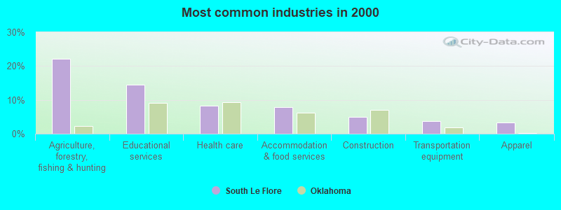
- Agriculture, forestry, fishing & hunting (22.2%)
- Educational services (14.4%)
- Health care (8.2%)
- Accommodation & food services (7.8%)
- Construction (4.9%)
- Transportation equipment (3.7%)
- Apparel (3.3%)
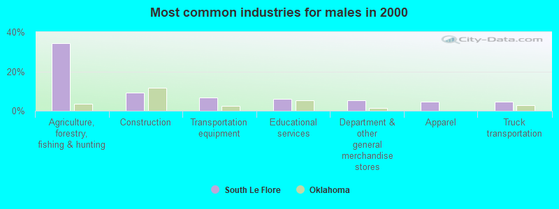
- Agriculture, forestry, fishing & hunting (34.4%)
- Construction (9.2%)
- Transportation equipment (6.9%)
- Educational services (6.1%)
- Department & other general merchandise stores (5.3%)
- Apparel (4.6%)
- Truck transportation (4.6%)
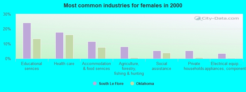
- Educational services (24.1%)
- Health care (17.9%)
- Accommodation & food services (11.6%)
- Agriculture, forestry, fishing & hunting (8.0%)
- Social assistance (5.4%)
- Private households (5.4%)
- Electrical equipment, appliances, components (3.6%)

- Fishing, hunting, and forestry occupations (11.1%)
- Building and grounds cleaning and maintenance occupations (8.2%)
- Preschool, kindergarten, elementary, and middle school teachers (7.0%)
- Driver/sales workers and truck drivers (4.9%)
- Nursing, psychiatric, and home health aides (4.5%)
- Other production occupations, including supervisors (4.5%)
- Farmers and farm managers (4.1%)

- Fishing, hunting, and forestry occupations (19.1%)
- Driver/sales workers and truck drivers (9.2%)
- Other production occupations, including supervisors (7.6%)
- Vehicle and mobile equipment mechanics, installers, and repairers (6.1%)
- Farmers and farm managers (4.6%)
- Other sales and related occupations, including supervisors (4.6%)
- Electrical equipment mechanics and other installation, maintenance, and repair workers, including supervisors (3.8%)

- Building and grounds cleaning and maintenance occupations (14.3%)
- Preschool, kindergarten, elementary, and middle school teachers (11.6%)
- Nursing, psychiatric, and home health aides (9.8%)
- Cooks and food preparation workers (5.4%)
- Other teachers, instructors, education, training, and library occupations (4.5%)
- Occupational and physical therapist assistants and aides (3.6%)
- Farmers and farm managers (3.6%)
Average climate in South Le Flore, Oklahoma
Based on data reported by over 4,000 weather stations


Tornado activity:
South Le Flore-area historical tornado activity is below Oklahoma state average. It is 59% greater than the overall U.S. average.
On 4/2/1982, a category F5 (max. wind speeds 261-318 mph) tornado 39.8 miles away from the South Le Flore place center injured 29 people and caused between $500,000 and $5,000,000 in damages.
On 5/5/1961, a category F4 (max. wind speeds 207-260 mph) tornado 23.9 miles away from the place center killed 16 people and injured 58 people and caused between $50,000 and $500,000 in damages.
Earthquake activity:
South Le Flore-area historical earthquake activity is significantly above Oklahoma state average. It is 588% greater than the overall U.S. average.On 11/6/2011 at 03:53:10, a magnitude 5.7 (5.7 MW, Depth: 3.2 mi, Class: Moderate, Intensity: VI - VII) earthquake occurred 136.6 miles away from the city center
On 9/3/2016 at 12:02:44, a magnitude 5.8 (5.8 MW, Depth: 3.5 mi) earthquake occurred 181.1 miles away from South Le Flore center
On 11/7/2016 at 01:44:24, a magnitude 5.0 (5.0 MW, Depth: 2.8 mi) earthquake occurred 155.9 miles away from the city center
On 11/5/2011 at 07:12:45, a magnitude 4.8 (4.8 MW, Depth: 1.9 mi, Class: Light, Intensity: IV - V) earthquake occurred 137.1 miles away from the city center
On 11/8/2011 at 02:46:57, a magnitude 4.8 (4.8 MW, Depth: 3.1 mi) earthquake occurred 137.7 miles away from the city center
On 2/28/2011 at 05:00:50, a magnitude 4.7 (4.7 MW, Depth: 2.0 mi) earthquake occurred 139.3 miles away from South Le Flore center
Magnitude types: moment magnitude (MW)
Natural disasters:
The number of natural disasters in Le Flore County (26) is a lot greater than the US average (15).Major Disasters (Presidential) Declared: 17
Emergencies Declared: 6
Causes of natural disasters: Storms: 15, Floods: 13, Tornadoes: 10, Winter Storms: 8, Winds: 4, Heavy Rain: 1, Hurricane: 1, Snow: 1, Other: 1 (Note: some incidents may be assigned to more than one category).
Colleges/universities with over 2000 students nearest to South Le Flore:
- Carl Albert State College (about 33 miles; Poteau, OK; Full-time enrollment: 2,041)
- University of Arkansas-Fort Smith (about 59 miles; Fort Smith, AR; FT enrollment: 6,103)
- Paris Junior College (about 81 miles; Paris, TX; FT enrollment: 3,875)
- Texarkana College (about 85 miles; Texarkana, TX; FT enrollment: 2,629)
- National Park Community College (about 88 miles; Hot Springs, AR; FT enrollment: 2,237)
- Northeastern State University (about 96 miles; Tahlequah, OK; FT enrollment: 6,895)
- Henderson State University (about 97 miles; Arkadelphia, AR; FT enrollment: 3,528)
Points of interest:
Notable locations in South Le Flore: Vertao Electronic Site (A), Kerr Natural Center (B), Kiamichi Mountain AT&T Electronic Site (C), Christs Forty Acres Camp (D), Octavia - Smithville Rural Fire Association Station 1 (E). Display/hide their locations on the map
Churches in South Le Flore include: Spring Hill Church (A), New Home Church (B), Page Church (C), Zafra Church (D). Display/hide their locations on the map
Cemeteries: McClure Cemetery (1), Octavia Cemetery (2), Spring Hill Cemetery (3), Big Cedar Cemetery (4), Ludlow Cemetery (5). Display/hide their locations on the map
Streams, rivers, and creeks: Honobia Creek (A), Cow Creek (B), Horse Bone Creek (C), Cedar Creek (D), Little Eagle Creek (E), Dark Hollow Branch (F), Brushy Creek (G), Rock Creek (H), Pigeon Creek (I). Display/hide their locations on the map
Parks in South Le Flore include: Robert S Kerr Arboretum (1), Beech Creek National Scenic Area (2). Display/hide their locations on the map
| This place: | 2.3 people |
| Oklahoma: | 2.5 people |
| This place: | 65.8% |
| Whole state: | 66.8% |
| This place: | 3.2% |
| Whole state: | 5.9% |
No gay or lesbian households reported
| This place: | 19.8% |
| Whole state: | 14.7% |
| This place: | 7.6% |
| Whole state: | 6.1% |
For population 15 years and over in South Le Flore:

- Never married: 17.8%
- Now married: 66.8%
- Separated: 2.4%
- Widowed: 7.1%
- Divorced: 8.3%
For population 25 years and over in South Le Flore:
- High school or higher: 76.3%
- Bachelor's degree or higher: 14.2%
- Graduate or professional degree: 3.3%
- Unemployed: 2.4%
- Mean travel time to work (commute): 30.9 minutes


| Here: | 13.3 |
| Oklahoma average: | 11.7 |
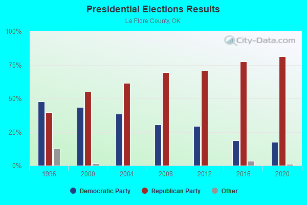
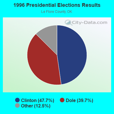
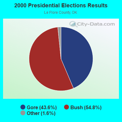
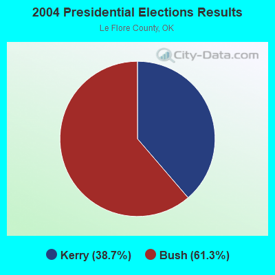
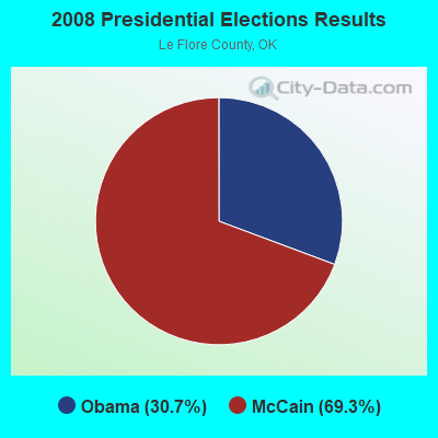
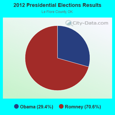
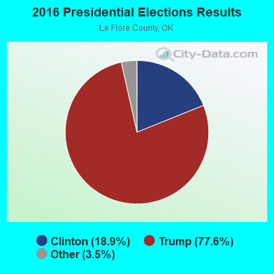
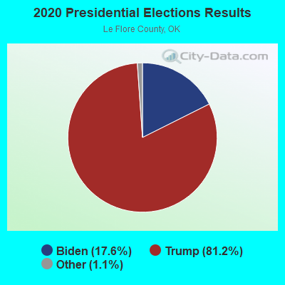
Graphs represent county-level data. Detailed 2008 Election Results
Religion statistics for South Le Flore, OK (based on Le Flore County data)
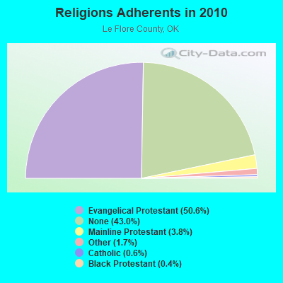
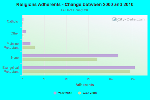
| Religion | Adherents | Congregations |
|---|---|---|
| Evangelical Protestant | 25,481 | 138 |
| Mainline Protestant | 1,891 | 15 |
| Other | 842 | 4 |
| Catholic | 303 | 3 |
| Black Protestant | 186 | 1 |
| None | 21,681 | - |
Food Environment Statistics:
| Le Flore County: | 1.62 / 10,000 pop. |
| Oklahoma: | 1.97 / 10,000 pop. |
| This county: | 0.20 / 10,000 pop. |
| Oklahoma: | 0.20 / 10,000 pop. |
| Le Flore County: | 1.21 / 10,000 pop. |
| Oklahoma: | 0.76 / 10,000 pop. |
| Le Flore County: | 7.07 / 10,000 pop. |
| State: | 4.35 / 10,000 pop. |
| This county: | 3.84 / 10,000 pop. |
| State: | 6.89 / 10,000 pop. |
| This county: | 12.8% |
| Oklahoma: | 10.3% |
| This county: | 28.8% |
| Oklahoma: | 29.2% |
Strongest AM radio stations in South Le Flore:
- KEEL (710 AM; 50 kW; SHREVEPORT, LA; Owner: CITICASTERS LICENSES, L.P.)
- KRMG (740 AM; 50 kW; TULSA, OK; Owner: CXR HOLDINGS, INC.)
- KGHT (880 AM; 50 kW; SHERIDAN, AR; Owner: METROPOLITAN RADIO GROUP, INC.)
- KFAQ (1170 AM; 50 kW; TULSA, OK; Owner: JOURNAL BROADCAST CORPORATION)
- KAAY (1090 AM; 50 kW; LITTLE ROCK, AR; Owner: CITADEL BROADCASTING COMPANY)
- KWKH (1130 AM; 50 kW; SHREVEPORT, LA; Owner: CITICASTERS LICENSES, L.P.)
- KYHN (1320 AM; 10 kW; FORT SMITH, AR; Owner: CAPSTAR TX LIMITED PARTNERSHIP)
- KFXR (1190 AM; 50 kW; DALLAS, TX; Owner: CLEAR CHANNEL BROADCASTING LICENSES, INC.)
- KRLD (1080 AM; 50 kW; DALLAS, TX; Owner: TEXAS INFINITY BROADCASTING L.P.)
- KWHN (1650 AM; 10 kW; FT. SMITH, AR; Owner: CAPSTAR TX LIMITED PARTNERSHIP)
- KWXI (670 AM; daytime; 5 kW; GLENWOOD, AR; Owner: PGR COMMUNICATIONS, INC.)
- WBAP (820 AM; 50 kW; FORT WORTH, TX; Owner: WBAP-KSCS OPERATING, LTD.)
- KENA (1450 AM; 1 kW; MENA, AR; Owner: OUACHITA BROADCASTING, INC)
Strongest FM radio stations in South Le Flore:
- KOMS (107.3 FM; POTEAU, OK; Owner: CUMULUS LICENSING CORP.)
- KZBB (97.9 FM; POTEAU, OK; Owner: CAPSTAR TX LIMITED PARTNERSHIP)
- KMAG (99.1 FM; FORT SMITH, AR; Owner: CAPSTAR TX LIMITED PARTNERSHIP)
- KTCS-FM (99.9 FM; FORT SMITH, AR; Owner: BIG CHIEF BROADCASTING COMPANY)
- K204EW (88.7 FM; POTEAU, OK; Owner: CALVARY CHAPEL OF TWIN FALLS, INC.)
- K219CN (91.7 FM; POTEAU, OK; Owner: AMERICAN FAMILY ASSOCIATION)
- KARG (91.7 FM; POTEAU, OK; Owner: AMERICAN FAMILY ASSOCIATION)
- KKBI (106.1 FM; BROKEN BOW, OK; Owner: J.D.C. RADIO, INC.)
- KQOR (105.3 FM; MENA, AR; Owner: OUACHITA BROADCASTING, INC.)
- KRWA-FM (103.1 FM; WALDRON, AR; Owner: PHARIS BROADCASTING, INC.)
- KPRV-FM (92.5 FM; HEAVENER, OK; Owner: LEROY BILLY)
- KTTG (96.3 FM; MENA, AR; Owner: PEARSON BROADCASTING OF MENA, INC.)
- KENA-FM (102.1 FM; MENA, AR; Owner: OUACHITA BROADCASTING, INC.)

- 58.0%Bottled, tank, or LP gas
- 21.5%Wood
- 15.5%Electricity
- 5.0%Utility gas

- 60.0%Bottled, tank, or LP gas
- 26.7%Wood
- 13.3%Electricity
South Le Flore compared to Oklahoma state average:
- Median household income below state average.
- Median house value below state average.
- Unemployed percentage significantly below state average.
- Black race population percentage significantly below state average.
- Hispanic race population percentage significantly below state average.
- Median age above state average.
- Foreign-born population percentage significantly below state average.
- Renting percentage significantly below state average.
- Length of stay since moving in significantly above state average.
- Number of rooms per house significantly below state average.
- House age significantly below state average.
- Number of college students below state average.
State forum archive: