Sheffield, Massachusetts
Submit your own pictures of this town and show them to the world
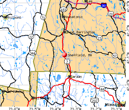
- OSM Map
- General Map
- Google Map
- MSN Map
Population change since 2000: -2.3%
 |
| Males: 1,618 | |
| Females: 1,639 |
| Median resident age: | 47.8 years |
| Massachusetts median age: | 39.2 years |
Zip codes: 01257.
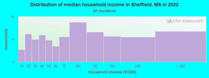
| Sheffield: | $85,640 |
| MA: | $94,488 |
Estimated per capita income in 2022: $57,178 (it was $25,492 in 2000)
Sheffield town income, earnings, and wages data
Estimated median house or condo value in 2022: $420,116 (it was $157,100 in 2000)
| Sheffield: | $420,116 |
| MA: | $534,700 |
Mean prices in 2022: all housing units: $357,971; detached houses: $376,086; townhouses or other attached units: $341,816; in 2-unit structures: $250,940; in 3-to-4-unit structures: $400,871; in 5-or-more-unit structures: $281,990; mobile homes: $80,872
Detailed information about poverty and poor residents in Sheffield, MA


- 3,07094.3%White alone
- 1053.2%Hispanic
- 341.0%Black alone
- 300.9%Two or more races
- 110.3%Asian alone
- 50.2%American Indian alone
- 20.06%Other race alone
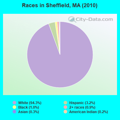
Races in Sheffield detailed stats: ancestries, foreign born residents, place of birth
According to our research of Massachusetts and other state lists, there were 2 registered sex offenders living in Sheffield, Massachusetts as of May 28, 2024.
The ratio of all residents to sex offenders in Sheffield is 1,629 to 1.
The ratio of registered sex offenders to all residents in this city is near the state average.
Full-time law enforcement employees in 2021, including police officers: 4 (4 officers - 4 male; 0 female).
| Officers per 1,000 residents here: | 1.29 |
| Massachusetts average: | 2.53 |
 Recent articles from our blog. Our writers, many of them Ph.D. graduates or candidates, create easy-to-read articles on a wide variety of topics.

 | Big MA Ancestry Data Thread by Town (31 replies) |
| Is it possible to escape hunters, ATVs and noise in a rural area? (278 replies) |
| Names of people arrested in Boston Sunday for rioting. (231 replies) |
| Favorite local breweries and craft beers (171 replies) |
| How is downtown Springfield? (140 replies) |
| Life in the farthest reaches of the Berkshires/Taconics? (8 replies) |
Latest news from Sheffield, MA collected exclusively by city-data.com from local newspapers, TV, and radio stations
Sheffield, MA City Guides:
Ancestries: English (18.7%), Irish (17.4%), German (12.9%), Italian (11.6%), French (7.7%), United States (7.4%).
Current Local Time: EST time zone
Incorporated in 1733
Elevation: 675 feet
Land area: 48.1 square miles.
Population density: 68 people per square mile (very low).
87 residents are foreign born (1.4% Europe, 0.6% Latin America, 0.4% North America).
| This town: | 2.6% |
| Massachusetts: | 12.2% |
| Sheffield town: | 1.3% ($2,066) |
| Massachusetts: | 1.3% ($2,336) |
Nearest city with pop. 50,000+: Bristol, CT  (36.1 miles , pop. 60,062).
Nearest city with pop. 200,000+: Bronx, NY (90.6 miles , pop. 1,332,650).
Nearest cities:
), ), ), ), )Latitude: 42.10 N, Longitude: 73.36 W
Area code: 413

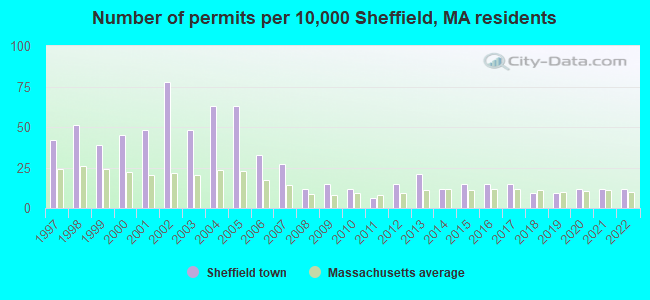
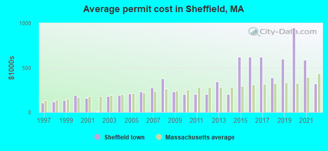
Single-family new house construction building permits:
- 2022: 4 buildings, average cost: $321,300
- 2021: 4 buildings, average cost: $587,500
- 2020: 4 buildings, average cost: $950,000
- 2019: 3 buildings, average cost: $600,000
- 2018: 3 buildings, average cost: $391,000
- 2017: 5 buildings, average cost: $620,000
- 2016: 5 buildings, average cost: $620,000
- 2015: 5 buildings, average cost: $620,000
- 2014: 4 buildings, average cost: $205,800
- 2013: 7 buildings, average cost: $346,500
- 2012: 5 buildings, average cost: $204,000
- 2011: 2 buildings, average cost: $205,000
- 2010: 4 buildings, average cost: $201,300
- 2009: 5 buildings, average cost: $231,100
- 2008: 4 buildings, average cost: $378,800
- 2007: 9 buildings, average cost: $278,500
- 2006: 11 buildings, average cost: $231,900
- 2005: 21 buildings, average cost: $207,800
- 2004: 21 buildings, average cost: $190,300
- 2003: 16 buildings, average cost: $180,600
- 2002: 26 buildings, average cost: $5,100
- 2001: 16 buildings, average cost: $157,300
- 2000: 15 buildings, average cost: $190,000
- 1999: 13 buildings, average cost: $134,600
- 1998: 17 buildings, average cost: $120,000
- 1997: 14 buildings, average cost: $105,900
| Here: | 3.0% |
| Massachusetts: | 3.5% |

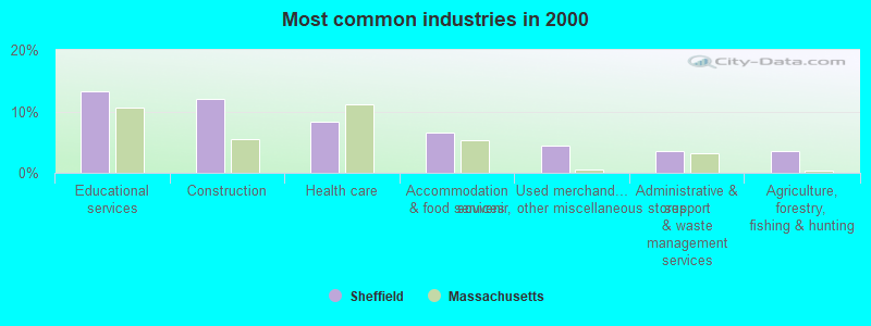
- Educational services (13.3%)
- Construction (12.1%)
- Health care (8.3%)
- Accommodation & food services (6.6%)
- Used merchandise, gift, novelty, souvenir, other miscellaneous stores (4.4%)
- Administrative & support & waste management services (3.6%)
- Agriculture, forestry, fishing & hunting (3.5%)
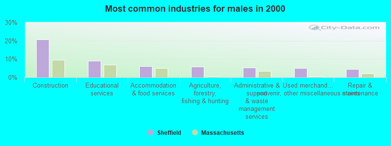
- Construction (20.8%)
- Educational services (8.9%)
- Accommodation & food services (6.2%)
- Agriculture, forestry, fishing & hunting (5.7%)
- Administrative & support & waste management services (5.2%)
- Used merchandise, gift, novelty, souvenir, other miscellaneous stores (5.1%)
- Repair & maintenance (4.5%)

- Educational services (18.5%)
- Health care (13.9%)
- Accommodation & food services (7.1%)
- Arts, entertainment, recreation (4.5%)
- Food & beverage stores (4.1%)
- Used merchandise, gift, novelty, souvenir, other miscellaneous stores (3.5%)
- Professional, scientific, technical services (3.4%)
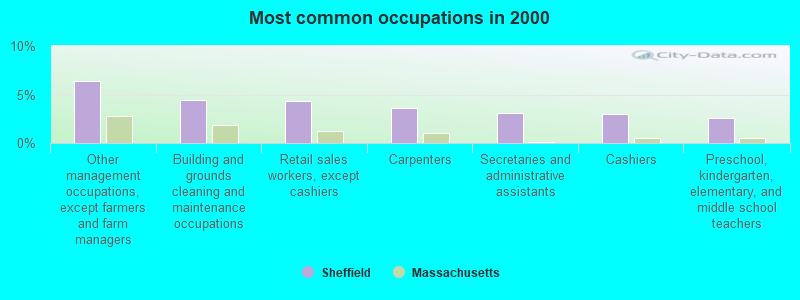
- Other management occupations, except farmers and farm managers (6.4%)
- Building and grounds cleaning and maintenance occupations (4.4%)
- Retail sales workers, except cashiers (4.4%)
- Carpenters (3.6%)
- Secretaries and administrative assistants (3.1%)
- Cashiers (3.0%)
- Preschool, kindergarten, elementary, and middle school teachers (2.6%)
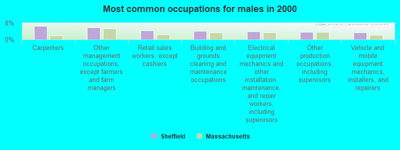
- Carpenters (6.6%)
- Other management occupations, except farmers and farm managers (5.7%)
- Retail sales workers, except cashiers (4.5%)
- Building and grounds cleaning and maintenance occupations (4.1%)
- Electrical equipment mechanics and other installation, maintenance, and repair workers, including supervisors (3.9%)
- Other production occupations, including supervisors (3.7%)
- Vehicle and mobile equipment mechanics, installers, and repairers (3.5%)
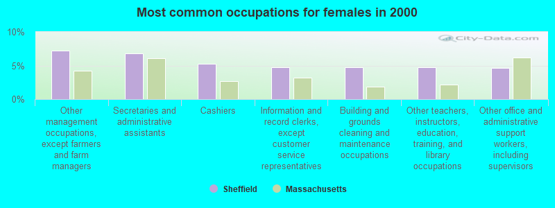
- Other management occupations, except farmers and farm managers (7.3%)
- Secretaries and administrative assistants (6.8%)
- Cashiers (5.3%)
- Information and record clerks, except customer service representatives (4.8%)
- Building and grounds cleaning and maintenance occupations (4.8%)
- Other teachers, instructors, education, training, and library occupations (4.8%)
- Other office and administrative support workers, including supervisors (4.6%)
Average climate in Sheffield, Massachusetts
Based on data reported by over 4,000 weather stations


(lower is better)
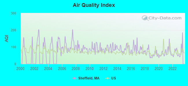
Air Quality Index (AQI) level in 2022 was 64.1. This is about average.
| City: | 64.1 |
| U.S.: | 72.6 |

Carbon Monoxide (CO) [ppm] level in 2022 was 0.149. This is significantly better than average. Closest monitor was 9.1 miles away from the city center.
| City: | 0.149 |
| U.S.: | 0.251 |
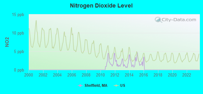
Nitrogen Dioxide (NO2) [ppb] level in 2015 was 2.27. This is significantly better than average. Closest monitor was 9.1 miles away from the city center.
| City: | 2.27 |
| U.S.: | 5.11 |
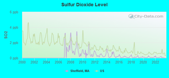
Sulfur Dioxide (SO2) [ppb] level in 2022 was 0.109. This is significantly better than average. Closest monitor was 9.1 miles away from the city center.
| City: | 0.109 |
| U.S.: | 1.515 |
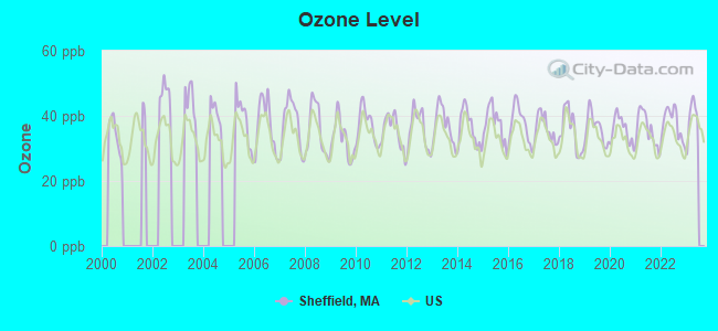
Ozone [ppb] level in 2022 was 37.6. This is about average. Closest monitor was 19.4 miles away from the city center.
| City: | 37.6 |
| U.S.: | 33.3 |
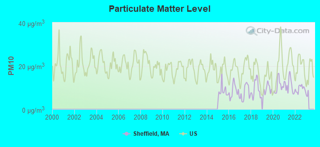
Particulate Matter (PM10) [µg/m3] level in 2022 was 9.49. This is significantly better than average. Closest monitor was 19.4 miles away from the city center.
| City: | 9.49 |
| U.S.: | 19.21 |
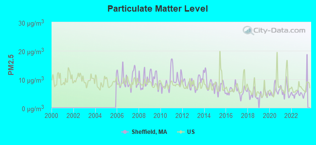
Particulate Matter (PM2.5) [µg/m3] level in 2022 was 4.86. This is significantly better than average. Closest monitor was 19.4 miles away from the city center.
| City: | 4.86 |
| U.S.: | 8.11 |
Tornado activity:
Sheffield-area historical tornado activity is slightly above Massachusetts state average. It is 17% smaller than the overall U.S. average.
On 5/29/1995, a category F4 (max. wind speeds 207-260 mph) tornado 7.9 miles away from the Sheffield town center killed 3 people and injured 24 people and caused between $5,000,000 and $50,000,000 in damages.
On 8/28/1973, a category F4 tornado 11.9 miles away from the town center killed 4 people and injured 36 people and caused between $5,000,000 and $50,000,000 in damages.
Earthquake activity:
Sheffield-area historical earthquake activity is significantly above Massachusetts state average. It is 69% smaller than the overall U.S. average.On 10/7/1983 at 10:18:46, a magnitude 5.3 (5.1 MB, 5.3 LG, 5.1 ML, Class: Moderate, Intensity: VI - VII) earthquake occurred 137.6 miles away from the city center
On 4/20/2002 at 10:50:47, a magnitude 5.3 (5.3 ML, Depth: 3.0 mi) earthquake occurred 167.8 miles away from the city center
On 4/20/2002 at 10:50:47, a magnitude 5.2 (5.2 MB, 4.2 MS, 5.2 MW, 5.0 MW) earthquake occurred 166.2 miles away from Sheffield center
On 1/19/1982 at 00:14:42, a magnitude 4.7 (4.5 MB, 4.7 MD, 4.5 LG, Class: Light, Intensity: IV - V) earthquake occurred 131.7 miles away from Sheffield center
On 10/16/2012 at 23:12:25, a magnitude 4.7 (4.7 ML, Depth: 10.0 mi) earthquake occurred 171.8 miles away from Sheffield center
On 8/23/2011 at 17:51:04, a magnitude 5.8 (5.8 MW, Depth: 3.7 mi) earthquake occurred 377.8 miles away from the city center
Magnitude types: regional Lg-wave magnitude (LG), body-wave magnitude (MB), duration magnitude (MD), local magnitude (ML), surface-wave magnitude (MS), moment magnitude (MW)
Natural disasters:
The number of natural disasters in Berkshire County (21) is greater than the US average (15).Major Disasters (Presidential) Declared: 10
Emergencies Declared: 10
Causes of natural disasters: Floods: 5, Snowstorms: 5, Storms: 5, Hurricanes: 4, Winter Storms: 4, Blizzards: 2, Snows: 2, Snowfall: 1, Tropical Storm: 1, Wind: 1, Other: 1 (Note: some incidents may be assigned to more than one category).

Hospitals and medical centers near Sheffield:
- KINDRED NRSING AND REHABILITATION-TIMBERLYN HEIGHTS (Nursing Home, about 6 miles away; GREAT BARRINGTON, MA)
- GREAT BARRINGTON REHABILITATION AND NURSING CENTER (Nursing Home, about 7 miles away; GREAT BARRINGTON, MA)
- FAIRVIEW HOSPITAL DIALYSIS CENTER (Dialysis Facility, about 7 miles away; GREAT BARRINGTON, MA)
- FAIRVIEW HOSPITAL Critical Access Hospitals (about 7 miles away; GREAT BARRINGTON, MA)
- NOBLE HORIZONS (Nursing Home, about 9 miles away; SALISBURY, CT)
- GEER NURSING AND REHABILITATIO (Nursing Home, about 10 miles away; CANAAN, CT)
- BERKSHIRE HEALTH CARE CENTER (Nursing Home, about 14 miles away; SANDISFIELD, MA)
Airports located in Sheffield:
- Cmelak Field Airport (MA18) (Runways: 2)
Colleges/universities with over 2000 students nearest to Sheffield:
- Bard College (about 29 miles; Annandale-On-Hudson, NY; Full-time enrollment: 3,137)
- Westfield State University (about 29 miles; Westfield, MA; FT enrollment: 5,548)
- Tunxis Community College (about 37 miles; Farmington, CT; FT enrollment: 2,787)
- Holyoke Community College (about 37 miles; Holyoke, MA; FT enrollment: 4,911)
- Dutchess Community College (about 39 miles; Poughkeepsie, NY; FT enrollment: 6,554)
- Culinary Institute of America (about 39 miles; Hyde Park, NY; FT enrollment: 3,869)
- University of Hartford (about 40 miles; West Hartford, CT; FT enrollment: 6,398)
Public high school in Sheffield:
- MT EVERETT REGIONAL (Students: 367, Location: 491 BERKSHIRE SCHOOL ROAD, Grades: 7-12)
Public elementary/middle schools in Sheffield:
- UNDERMOUNTAIN (Students: 405, Location: 491 BERKSHIRE SCHOOL ROAD, Grades: PK-6)
- SOUTH EGREMONT (Students: 15, Location: 491 BERKSHIRE SCHOOL ROAD, Grades: KG-1)
Points of interest:
Notable locations in Sheffield: Sheffield Fire Department (A), Mount Everett Regional School Library (B), Colonel Ashley House (C), Sheffield Town Hall (D). Display/hide their locations on the map
Church in Sheffield: Grace Bible Church (A). Display/hide its location on the map
Cemeteries: Churchill Cemetery (1), Center Cemetery (2), Hewins Cemetery (3), Barnard Cemetery (4). Display/hide their locations on the map
Lakes, reservoirs, and swamps: Fawn Lake (A), Davis Pond (B), Harman Marsh Pond (C), Spurr Lake (D), Threemile Pond (E), Combes Pond (F), Berkshire Trout Pond (G), Mill Pond (H). Display/hide their locations on the map
Streams, rivers, and creeks: Schenob Brook (A), Konkapot River (B), Willard Brook (C), Stony Brook (D), Soda Creek (E), Race Brook (F), Ironwork Brook (G), Hubbard Brook (H), Dry Brook (I). Display/hide their locations on the map
Parks in Sheffield include: Bartholomews Cobble (1), Sheffield Plain Historic District (2), Battlesite Monument (3). Display/hide their locations on the map
Hotel: Ramblewood Inn (Under Mountain Road) (1). Display/hide its approximate location on the map
Court: Dewey Court (3 Dewey Way) (1). Display/hide its approximate location on the map
Birthplace of: David Joyce - Businessman, Frederick Augustus Porter Barnard.
Drinking water stations with addresses in Sheffield and their reported violations in the past:
SHEFFIELD WATER COMPANY (Population served: 965, Groundwater):Past health violations:BERKSHIRE SCHOOL (Address: 245 N UNDERMOUNTAIN RD , Population served: 475, Groundwater):
- MCL, Monthly (TCR) - In NOV-2012, Contaminant: Coliform. Follow-up actions: St AO (w/o penalty) issued (NOV-20-2012)
- MCL, Monthly (TCR) - In JUL-2009, Contaminant: Coliform. Follow-up actions: St AO (w/o penalty) issued (OCT-01-2009)
- MCL, Monthly (TCR) - In JUN-2009, Contaminant: Coliform. Follow-up actions: St AO (w/o penalty) issued (2 times from JUL-27-2009 to OCT-01-2009)
Past health violations:Past monitoring violations:
- MCL, Monthly (TCR) - In JUL-2014, Contaminant: Coliform. Follow-up actions: St AO (w/o penalty) issued (AUG-15-2014)
- MCL, Monthly (TCR) - In JUN-2013, Contaminant: Coliform. Follow-up actions: St AO (w/o penalty) issued (JUL-22-2013)
- One regular monitoring violation
| This town: | 2.3 people |
| Massachusetts: | 2.5 people |
| This town: | 61.7% |
| Whole state: | 63.0% |
| This town: | 8.8% |
| Whole state: | 7.0% |
Likely homosexual households (counted as self-reported same-sex unmarried-partner households)
- Lesbian couples: 0.7% of all households
- Gay men: 0.7% of all households
| This town: | 5.3% |
| Whole state: | 9.3% |
| This town: | 3.3% |
| Whole state: | 4.4% |
12 people in other group homes in 2000
2 people in other nonhousehold living situations in 2000
Banks with branches in Sheffield (2011 data):
- Berkshire Bank: Sheffield Branch at 103 Main Street, branch established on 1966/11/21. Info updated 2011/08/24: Bank assets: $3,955.6 mil, Deposits: $3,176.2 mil, headquarters in Pittsfield, MA, positive income, Commercial Lending Specialization, 64 total offices
- Salisbury Bank and Trust Company: Sheffield Branch at 640 North Main Street, branch established on 2005/03/14. Info updated 2010/09/29: Bank assets: $608.2 mil, Deposits: $480.4 mil, headquarters in Lakeville, CT, positive income, 8 total offices, Holding Company: Salisbury Bancorp, Inc.
For population 15 years and over in Sheffield:
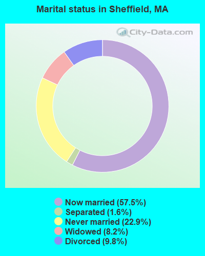
- Never married: 22.9%
- Now married: 57.5%
- Separated: 1.6%
- Widowed: 8.2%
- Divorced: 9.8%
For population 25 years and over in Sheffield:
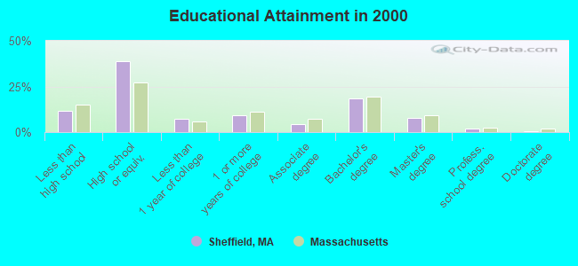
- High school or higher: 88.1%
- Bachelor's degree or higher: 28.3%
- Graduate or professional degree: 10.0%
- Unemployed: 2.5%
- Mean travel time to work (commute): 22.6 minutes
| Here: | 11.2 |
| Massachusetts average: | 13.1 |


Graphs represent county-level data. Detailed 2008 Election Results
Religion statistics for Sheffield, MA (based on Berkshire County data)


| Religion | Adherents | Congregations |
|---|---|---|
| Catholic | 50,187 | 32 |
| Mainline Protestant | 9,895 | 63 |
| Other | 3,647 | 20 |
| Evangelical Protestant | 2,817 | 28 |
| Black Protestant | 233 | 2 |
| Orthodox | 225 | 2 |
| None | 64,215 | - |
Food Environment Statistics:
| This county: | 2.54 / 10,000 pop. |
| Massachusetts: | 1.98 / 10,000 pop. |
| Here: | 1.61 / 10,000 pop. |
| Massachusetts: | 2.22 / 10,000 pop. |
| Berkshire County: | 4.08 / 10,000 pop. |
| Massachusetts: | 1.77 / 10,000 pop. |
| Berkshire County: | 15.00 / 10,000 pop. |
| Massachusetts: | 8.76 / 10,000 pop. |
| Berkshire County: | 8.0% |
| Massachusetts: | 8.1% |
| Berkshire County: | 22.8% |
| Massachusetts: | 22.5% |
| This county: | 9.9% |
| Massachusetts: | 16.5% |
Strongest AM radio stations in Sheffield:
- WNNZ (640 AM; 50 kW; WESTFIELD, MA; Owner: CLEAR CHANNEL BROADCASTING LICENSES, INC.)
- WSBS (860 AM; 3 kW; GREAT BARRINGTON, MA; Owner: BERKSHIRE BROADCASTING CO., INC.)
- WTIC (1080 AM; 50 kW; HARTFORD, CT; Owner: INFINITY RADIO OPERATIONS INC.)
- WGY (810 AM; 50 kW; SCHENECTADY, NY; Owner: CLEAR CHANNEL BROADCASTING LICENSES, INC.)
- WKZE (1020 AM; daytime; 2 kW; SHARON, CT; Owner: JOHNSON DEVELOPMENT, INC.)
- WPTR (1540 AM; 50 kW; ALBANY, NY; Owner: KIMTRON, INC.)
- WCRN (830 AM; 50 kW; WORCESTER, MA; Owner: CARTER BROADCASTING CORPORATION)
- WFAN (660 AM; 50 kW; NEW YORK, NY; Owner: INFINITY BROADCASTING OPERATIONS, INC.)
- WMCA (570 AM; 50 kW; NEW YORK, NY; Owner: SALEM MEDIA OF NEW YORK, LLC)
- WUHN (1110 AM; daytime; 5 kW; PITTSFIELD, MA; Owner: WEINER BROADCASTING, INC.)
- WABC (770 AM; 50 kW; NEW YORK, NY; Owner: WABC-AM RADIO, INC.)
- WVNE (760 AM; daytime; 25 kW; LEICESTER, MA; Owner: BLOUNT MASSCOM, INC.)
- WCBS (880 AM; 50 kW; NEW YORK, NY; Owner: INFINITY BROADCASTING OPERATIONS, INC.)
Strongest FM radio stations in Sheffield:
- WAMQ (105.1 FM; GREAT BARRINGTON, MA; Owner: WAMC)
- WHVP (91.1 FM; HUDSON, NY; Owner: SOUND OF LIFE, INC.)
- WAMC-FM (90.3 FM; ALBANY, NY; Owner: WAMC)
- WKZE-FM (98.1 FM; SALISBURY, CT; Owner: JOHNSON DEVELOPMENT, INC.)
- WAMK (90.9 FM; KINGSTON, NY; Owner: W A M C)
- WFGB (89.7 FM; KINGSTON, NY; Owner: SOUND OF LIFE, INC.)
- WQQQ (103.3 FM; SHARON, CT; Owner: THE RIDGEFIELD BROADCASTING CORPORATION)
- WPDH (101.5 FM; POUGHKEEPSIE, NY; Owner: CUMULUS LICENSING CORP.)
- WRCH (100.5 FM; NEW BRITAIN, CT; Owner: INFINITY RADIO OPERATIONS INC.)
- WBEC-FM (105.5 FM; PITTSFIELD, MA; Owner: GREAT NORTHERN RADIO, LLC)
- WUPE (95.9 FM; PITTSFIELD, MA; Owner: WEINER BROADCASTING, INC.)
- WFNP (88.7 FM; ROSENDALE, NY; Owner: STATE UNIVERSITY OF NEW YORK)
- WRHV (88.7 FM; POUGHKEEPSIE, NY; Owner: WMHT EDUCATIONAL TELECOMMUNICATIONS)
- WRNQ (92.1 FM; POUGHKEEPSIE, NY; Owner: CLEAR CHANNEL BROADCASTING LICENSES, INC.)
- W206AW (89.1 FM; PAWLING, NY; Owner: SOUND OF LIFE, INC.)
- WHYN-FM (93.1 FM; SPRINGFIELD, MA; Owner: CLEAR CHANNEL BROADCASTING LICENSES, INC.)
- WSGG (89.3 FM; NORFOLK, CT; Owner: REVIVAL CHRISTIAN MINISTRIES, INC.)
- W218AV (91.5 FM; WARREN, CT; Owner: MONROE BOARD OF EDUCATION)
- WAQY (102.1 FM; SPRINGFIELD, MA; Owner: SAGA COMMUNICATIONS OF NEW ENGLAND, LLC)
- WRNX (100.9 FM; AMHERST, MA; Owner: WESTERN MASSACHUSETTS RADIO COMPANY)
TV broadcast stations around Sheffield:
- WTIC-TV (Channel 61; HARTFORD, CT; Owner: TRIBUNE TELEVISION COMPANY)
- W11BJ (Channel 11; HARTFORD, CT; Owner: COMMUNICATIONS SITE MANAGEMENT LLC)
- WTXX (Channel 20; WATERBURY, CT; Owner: WTXX INC.)
- WUVN (Channel 18; HARTFORD, CT; Owner: ENTRAVISION HOLDINGS, LLC)
- WVIT (Channel 30; NEW BRITAIN, CT; Owner: OUTLET BROADCASTING, INC)
- WEDH (Channel 24; HARTFORD, CT; Owner: CONNECTICUT PUBLIC BROADCASTING, INC.)
Medal of Honor Recipients
Medal of Honor Recipient born in Sheffield: Frederick N. Deland.
- National Bridge Inventory (NBI) Statistics
- 20Number of bridges
- 177ft / 54.4mTotal length
- $37,662,000Total costs
- 46,444Total average daily traffic
- 2,561Total average daily truck traffic
- 46,495Total future (year 2031) average daily traffic
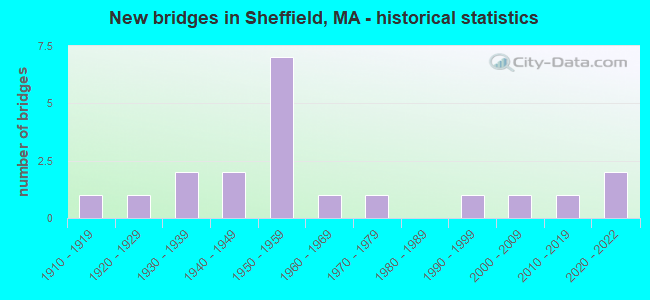
- New bridges - historical statistics
- 11910-1919
- 11920-1929
- 21930-1939
- 21940-1949
- 71950-1959
- 11960-1969
- 11970-1979
- 11990-1999
- 12000-2009
- 12010-2019
- 22020-2022
FCC Registered Cell Phone Towers:
2 (See the full list of FCC Registered Cell Phone Towers in Sheffield)FCC Registered Antenna Towers:
6 (See the full list of FCC Registered Antenna Towers)FCC Registered Broadcast Land Mobile Towers:
6- Railroad St (Lat: 42.111194 Lon: -73.325944), Call Sign: KNBU763,
Assigned Frequencies: 154.310 MHz, Grant Date: 11/04/2011, Expiration Date: 10/16/2021, Cancellation Date: 12/18/2021, Registrant: Washington Radio Reports, 1588 Fairfield Road Ste 7, Gettysburg, PA 17325, Phone: (717) 334-0668, Fax: (717) 334-6440
- Lat: 42.107306 Lon: -73.355111, Call Sign: WPNZ202,
Assigned Frequencies: 154.950 MHz, Grant Date: 10/03/2014, Expiration Date: 08/09/2024, Certifier: James J Mcgarry, Registrant: Pittsfield Communications Systems, Inc, 1502 W. Housatonic Street, Pittsfield, MA 01201, Phone: (413) 448-8214, Fax: (413) 448-6263, Email:
- Lime Kiln Rd (Lat: 42.154250 Lon: -73.369000), Call Sign: WQQ762,
Assigned Frequencies: 43.0200 MHz, Grant Date: 03/24/2015, Expiration Date: 06/20/2025, Registrant: Atlantic Communications, Inc., 40 Freedom Parkway, Hermon, Me 04401, Bangor, ME 04402-0596, Phone: (207) 848-7590, Fax: (207) 974-3151, Email:
- MAPLE AVENUE WELL, 176 Maple Avenue (Lat: 42.107667 Lon: -73.344806), Type: Pole, Structure height: 10 m, Call Sign: WQPL743,
Assigned Frequencies: 173.396 MHz, Grant Date: 06/22/2012, Expiration Date: 06/22/2022, Cancellation Date: 08/27/2022, Certifier: Beth Bartholomew, Registrant: Siemens Industry Inc, 1239 Willow Lake Blvd, Vadnais Heights, MN 55110, Phone: (651) 766-2700, Fax: (561) 766-2701, Email:
- 245 North Undermountain Road (Lat: 42.114861 Lon: -73.413917), Type: Building, Structure height: 14 m, Call Sign: WQTM328,
Assigned Frequencies: 465.000 MHz, 462.750 MHz, Grant Date: 03/04/2014, Expiration Date: 03/04/2024, Certifier: John Alden, Registrant: Visiplex, Inc., 1287 North Barclay Boulevard, Buffalo Grove, IL 60089, Phone: (847) 229-0250, Fax: (847) 229-0259, Email:
- Lat: 42.117139 Lon: -73.416167, Call Sign: WQXM953,
Assigned Frequencies: 72.1000 MHz, Grant Date: 04/19/2016, Expiration Date: 04/19/2026, Certifier: Tim Fulco, Registrant: Primex Wireless Inc, 965 Wells St., Lake Geneva, WI 53147, Phone: (800) 537-0464, Email:
FCC Registered Maritime Coast & Aviation Ground Towers:
1- Rt 7 (Lat: 42.127861 Lon: -73.363722), Call Sign: WRLA2077,
Assigned Frequencies: 75.0000 MHz, Grant Date: 08/26/1993, Expiration Date: 08/26/1998, Cancellation Date: 05/06/2001, Registrant: Massachusetts, Commonwealth Of, 10 Park Plz Rm 6620, Boston, MA 02116
FCC Registered Amateur Radio Licenses:
19 (See the full list of FCC Registered Amateur Radio Licenses in Sheffield)FAA Registered Aircraft:
3- Aircraft: CESSNA 336 (Category: Land, Engines: 2, Seats: 4, Weight: Up to 12,499 Pounds, Speed: 135 mph), Engine: CONT MOTOR IO-360 SER (300 HP) (Reciprocating)
N-Number: 1768Z, N1768Z, N-1768Z, Serial Number: 336-0068, Year manufactured: 1963, Airworthiness Date: 09/26/1963, Certificate Issue Date: 08/01/2020
Registrant (Individual): Craig B Moskowitz, 1220 Berkshire School Rd, Sheffield, MA 01257 - Aircraft: PIPER PA-15 (Category: Land, Seats: 2, Weight: Up to 12,499 Pounds, Speed: 75 mph), Engine: LYCOMING 0-145B SERIES (65 HP) (Reciprocating)
N-Number: 4487H, N4487H, N-4487H, Serial Number: 15-276, Year manufactured: 1948, Airworthiness Date: 06/24/1956, Certificate Issue Date: 08/10/2006
Registrant (Individual): Noel Anderson, Po Box 242, Sheffield, MA 01257 - Aircraft: PIPER PA-12 (Category: Land, Seats: 3, Weight: Up to 12,499 Pounds, Speed: 82 mph), Engine: LYCOMING 0-235 SERIES (115 HP) (Reciprocating)
N-Number: 2798M, N2798M, N-2798M, Serial Number: 12-1198, Year manufactured: 1946
Registrant (Individual): Frank Farrar, Stage Coach Rd, Sheffield, MA 01257
Deregistered: Cancel Date: 11/15/2019
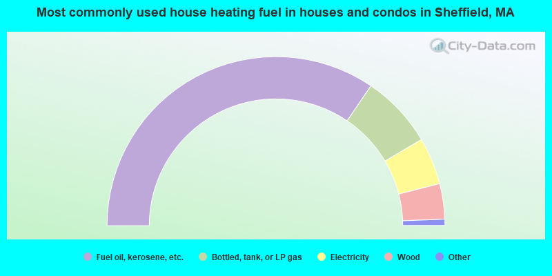
- 69.0%Fuel oil, kerosene, etc.
- 14.0%Bottled, tank, or LP gas
- 9.0%Electricity
- 6.8%Wood
- 0.6%Utility gas
- 0.6%Solar energy
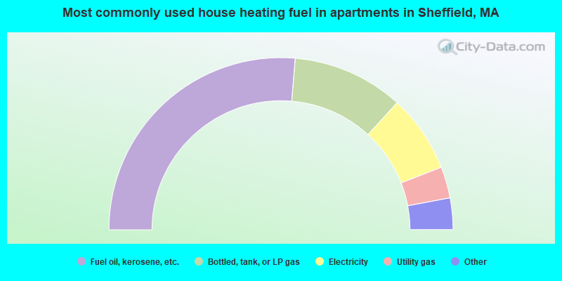
- 52.6%Fuel oil, kerosene, etc.
- 20.9%Bottled, tank, or LP gas
- 14.6%Electricity
- 5.9%Utility gas
- 3.1%Coal or coke
- 2.8%Other fuel
Sheffield compared to Massachusetts state average:
- Unemployed percentage significantly below state average.
- Black race population percentage significantly below state average.
- Hispanic race population percentage significantly below state average.
- Median age significantly above state average.
- Foreign-born population percentage significantly below state average.
- Renting percentage below state average.
- Length of stay since moving in significantly above state average.
- Number of rooms per house significantly below state average.
- House age significantly below state average.
- Number of college students below state average.

|
|
Total of 6 patent applications in 2008-2024.