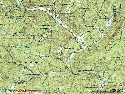
Rockingham, Vermont
Submit your own pictures of this town and show them to the world
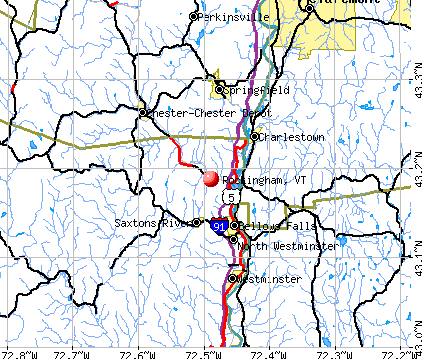
- OSM Map
- General Map
- Google Map
- MSN Map
Population change since 2000: -0.5%
 |
| Males: 2,538 | |
| Females: 2,744 |
| Median resident age: | 42.5 years |
| Vermont median age: | 45.8 years |
Zip codes: 05101.
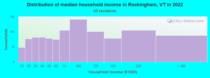
| Rockingham: | $57,262 |
| VT: | $73,991 |
Estimated per capita income in 2022: $37,888 (it was $19,051 in 2000)
Rockingham town income, earnings, and wages data
Estimated median house or condo value in 2022: $223,417 (it was $89,800 in 2000)
| Rockingham: | $223,417 |
| VT: | $304,700 |
Mean prices in 2022: all housing units: $298,935; detached houses: $317,292; townhouses or other attached units: $299,018; in 2-unit structures: $292,940; in 3-to-4-unit structures: $427,770; in 5-or-more-unit structures: $214,034; mobile homes: $65,502
Detailed information about poverty and poor residents in Rockingham, VT
Compare current foreclosures near Rockingham, VT:
| Photo | Address | Area | Beds / Baths | Price | Details |
|---|---|---|---|---|---|

|
#1
Byrd Ave
Claremont, NH 03743
|
1,021 sq. feet
|
1 baths 3 beds |
show details | |

|
#2
Elm St
Claremont, NH 03743
|
2,176 sq. feet
|
2 baths 5 beds |
show details | |

|
#3
Laura Ln
Keene, NH 03431
|
912 sq. feet
|
1 baths 3 beds |
show details | |

|
#4
Taylor Hill Rd
Charlestown, NH 03603
|
2,226 sq. feet
|
2 baths 4 beds |
show details | |

|
#5
Old Springfield Rd
Charlestown, NH 03603
|
1,848 sq. feet
|
1 baths 4 beds |
show details | |

|
#6
James St
Charlestown, NH 03603
|
1,032 sq. feet
|
2 baths 2 beds |
show details | |

|
#7
Acworth Rd
Charlestown, NH 03603
|
1,826 sq. feet
|
1 baths 3 beds |
show details | |

|
#8
Morways Park
Charlestown, NH 03603
|
1,064 sq. feet
|
2 baths 2 beds |
show details | |

|
#9
Pine Grove St
Claremont, NH 03743
|
2,304 sq. feet
|
1 baths 3 beds |
show details | |

|
#10
2nd Nh Tpke
Claremont, NH 03743
|
1,975 sq. feet
|
1 baths 3 beds |
show details |
| Photo | Address | Area | Beds / Baths | Price | Details |
|---|---|---|---|---|---|

|
#11
Edgebrook Park
Bellows Falls, VT 05101
|
- sq. feet
|
- baths - beds |
show details | |

|
#12
Roberts Rd
Springfield, VT 05156
|
- sq. feet
|
- baths - beds |
show details | |

|
#13
Lincoln Hts
Claremont, NH 03743
|
- sq. feet
|
- baths - beds |
show details | |

|
#14
Franklin St Frnt A
Claremont, NH 03743
|
- sq. feet
|
- baths - beds |
show details | |

|
#15
Gilsum Mine Rd
Alstead, NH 03602
|
- sq. feet
|
- baths - beds |
show details | |

|
#16
Baine Way
Alstead, NH 03602
|
- sq. feet
|
- baths - beds |
show details | |

|
#17
Dogwood Ln
Springfield, VT 05156
|
- sq. feet
|
- baths - beds |
show details | |

|
#18
Westview Ter
Springfield, VT 05156
|
- sq. feet
|
- baths - beds |
show details | |

|
#19
Library Ave
Alstead, NH 03602
|
- sq. feet
|
- baths - beds |
show details | |

|
#20
River St
Alstead, NH 03602
|
- sq. feet
|
- baths - beds |
show details |
| Photo | Address | Area | Beds / Baths | Price | Details |
|---|---|---|---|---|---|

|
#21
Court St Apt I
Keene, NH 03431
|
- sq. feet
|
- baths - beds |
show details | |

|
#22
Atkinson St
Bellows Falls, VT 05101
|
- sq. feet
|
- baths - beds |
show details | |

|
#23
Paine Rd
Westmoreland, NH 03467
|
- sq. feet
|
- baths - beds |
show details | |

|
#24
Upper Falls Rd
Perkinsville, VT 05151
|
- sq. feet
|
- baths - beds |
show details | |

|
#25
Taylor Dr
Springfield, VT 05156
|
- sq. feet
|
- baths - beds |
show details | |

|
#26
Mill St
Cavendish, VT 05142
|
- sq. feet
|
- baths - beds |
show details | |

|
#27
Center St
North Walpole, NH 03609
|
- sq. feet
|
- baths - beds |
show details | |

|
Check over 1 million property listings on Foreclosure.com!
|
browse all offers | |||

- 4,97194.1%White alone
- 1282.4%Two or more races
- 931.8%Hispanic
- 380.7%Asian alone
- 310.6%Black alone
- 120.2%American Indian alone
- 60.1%Native Hawaiian and Other
Pacific Islander alone - 30.06%Other race alone
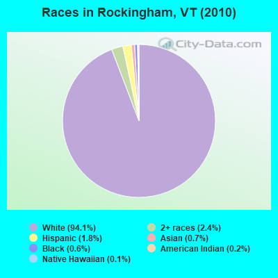
Races in Rockingham detailed stats: ancestries, foreign born residents, place of birth
According to our research of Vermont and other state lists, there was 1 registered sex offender living in Rockingham, Vermont as of May 29, 2024.
The ratio of all residents to sex offenders in Rockingham is 5,282 to 1.
The ratio of registered sex offenders to all residents in this city is much lower than the state average.
 Recent articles from our blog. Our writers, many of them Ph.D. graduates or candidates, create easy-to-read articles on a wide variety of topics.

 | Official Vermont Picture Thread (966 replies) |
| Anyone Inconvenienced by the Suspension of Amtrak Service to Vermont? (23 replies) |
| Vermont will pay you $10,000 to move there. (47 replies) |
| Wanting to relocate to VT from NY (11 replies) |
| Vacation Help (25 replies) |
| Keep your lawn trimmed in Rockingham (4 replies) |
Latest news from Rockingham, VT collected exclusively by city-data.com from local newspapers, TV, and radio stations
Ancestries: Irish (18.3%), French (16.7%), English (15.6%), German (8.1%), Polish (7.1%), United States (5.4%).
Current Local Time: EST time zone
Elevation: 487 feet
Land area: 41.9 square miles.
Population density: 126 people per square mile (very low).
140 residents are foreign born (0.9% Asia, 0.8% Europe, 0.5% Latin America, 0.4% North America).
| This town: | 2.6% |
| Vermont: | 3.8% |
| Rockingham town: | 2.9% ($2,602) |
| Vermont: | 2.0% ($2,196) |
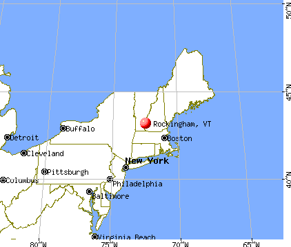
Nearest city with pop. 50,000+: Manchester, NH  (53.5 miles , pop. 107,006).
Nearest city with pop. 200,000+: Boston, MA (91.7 miles , pop. 589,141).
Nearest city with pop. 1,000,000+: Bronx, NY (175.6 miles , pop. 1,332,650).
Nearest cities:
), ), ), ), ), Latitude: 43.17 N, Longitude: 72.48 W
Area code commonly used in this area: 802

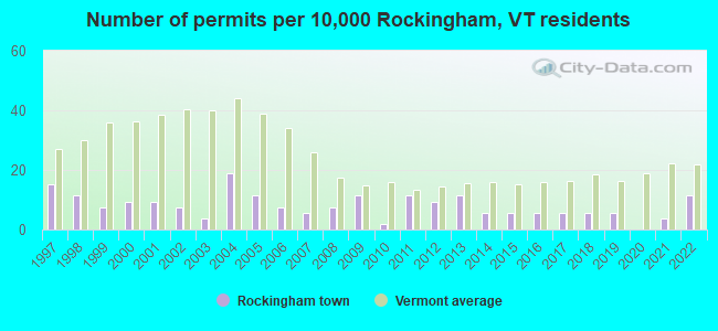
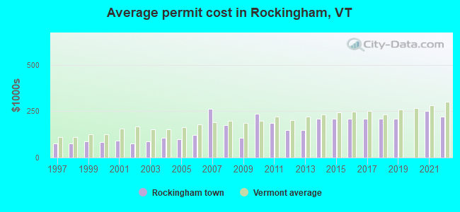
Single-family new house construction building permits:
- 2022: 6 buildings, average cost: $220,800
- 2021: 2 buildings, average cost: $250,000
- 2019: 3 buildings, average cost: $211,200
- 2018: 3 buildings, average cost: $211,200
- 2017: 3 buildings, average cost: $211,200
- 2016: 3 buildings, average cost: $211,200
- 2015: 3 buildings, average cost: $211,200
- 2014: 3 buildings, average cost: $211,200
- 2013: 6 buildings, average cost: $149,000
- 2012: 5 buildings, average cost: $149,000
- 2011: 6 buildings, average cost: $187,700
- 2010: 1 building, cost: $235,000
- 2009: 6 buildings, average cost: $104,500
- 2008: 4 buildings, average cost: $173,800
- 2007: 3 buildings, average cost: $261,700
- 2006: 4 buildings, average cost: $120,500
- 2005: 6 buildings, average cost: $101,200
- 2004: 10 buildings, average cost: $107,600
- 2003: 2 buildings, average cost: $87,500
- 2002: 4 buildings, average cost: $78,300
- 2001: 5 buildings, average cost: $90,400
- 2000: 5 buildings, average cost: $81,600
- 1999: 4 buildings, average cost: $86,200
- 1998: 6 buildings, average cost: $76,500
- 1997: 8 buildings, average cost: $76,500
| Here: | 2.4% |
| Vermont: | 2.0% |
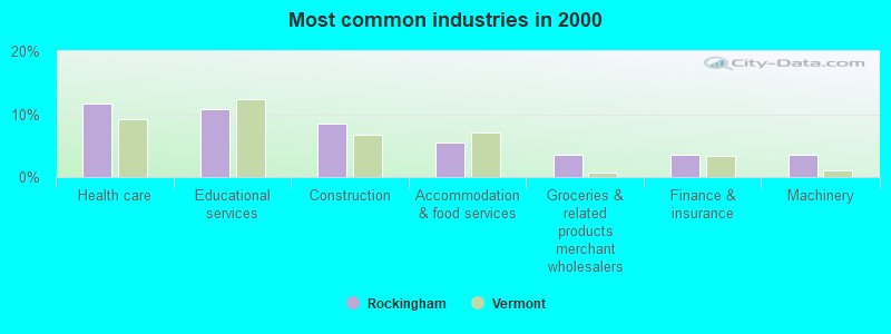
- Health care (11.7%)
- Educational services (10.9%)
- Construction (8.4%)
- Accommodation & food services (5.4%)
- Groceries & related products merchant wholesalers (3.6%)
- Finance & insurance (3.5%)
- Machinery (3.5%)
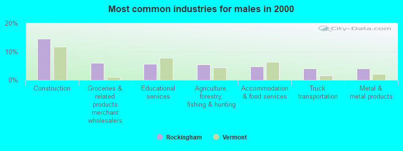
- Construction (14.4%)
- Groceries & related products merchant wholesalers (6.0%)
- Educational services (5.6%)
- Agriculture, forestry, fishing & hunting (5.5%)
- Accommodation & food services (4.9%)
- Truck transportation (4.1%)
- Metal & metal products (4.0%)
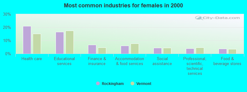
- Health care (20.9%)
- Educational services (16.4%)
- Finance & insurance (6.8%)
- Accommodation & food services (6.0%)
- Social assistance (4.4%)
- Professional, scientific, technical services (4.0%)
- Food & beverage stores (3.8%)
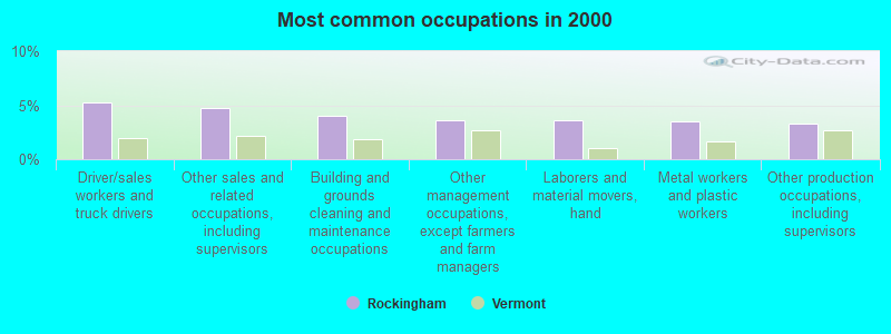
- Driver/sales workers and truck drivers (5.3%)
- Other sales and related occupations, including supervisors (4.8%)
- Building and grounds cleaning and maintenance occupations (4.0%)
- Other management occupations, except farmers and farm managers (3.6%)
- Laborers and material movers, hand (3.6%)
- Metal workers and plastic workers (3.5%)
- Other production occupations, including supervisors (3.3%)
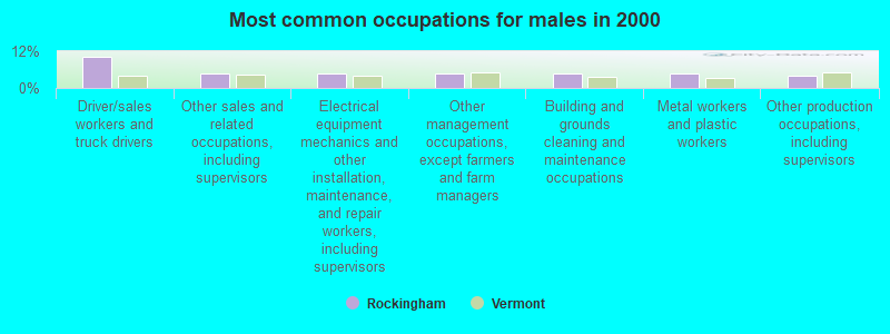
- Driver/sales workers and truck drivers (10.2%)
- Other sales and related occupations, including supervisors (4.9%)
- Electrical equipment mechanics and other installation, maintenance, and repair workers, including supervisors (4.9%)
- Other management occupations, except farmers and farm managers (4.8%)
- Building and grounds cleaning and maintenance occupations (4.7%)
- Metal workers and plastic workers (4.6%)
- Other production occupations, including supervisors (4.1%)
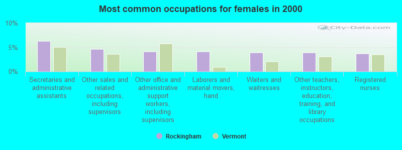
- Secretaries and administrative assistants (6.3%)
- Other sales and related occupations, including supervisors (4.7%)
- Other office and administrative support workers, including supervisors (4.1%)
- Laborers and material movers, hand (4.1%)
- Waiters and waitresses (4.0%)
- Other teachers, instructors, education, training, and library occupations (3.9%)
- Registered nurses (3.7%)
Average climate in Rockingham, Vermont
Based on data reported by over 4,000 weather stations


(lower is better)
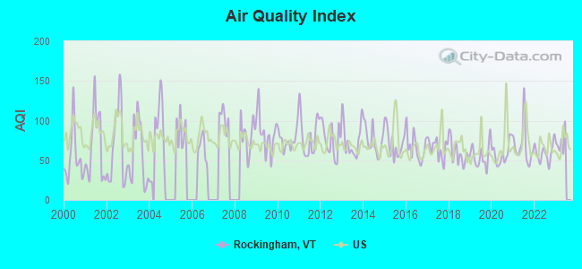
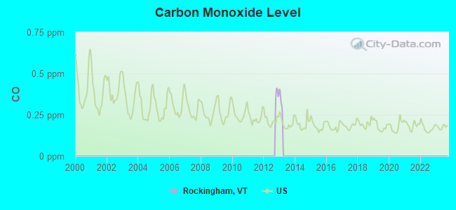
Air Quality Index (AQI) level in 2022 was 59.0. This is better than average.
| City: | 59.0 |
| U.S.: | 72.6 |
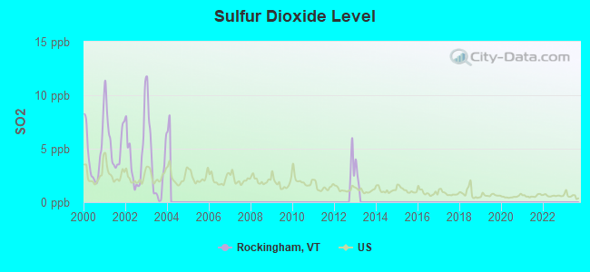
Sulfur Dioxide (SO2) [ppb] level in 2003 was 3.66. This is significantly worse than average. Closest monitor was 8.9 miles away from the city center.
| City: | 3.66 |
| U.S.: | 1.51 |
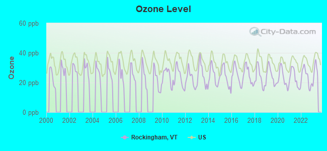
Ozone [ppb] level in 2022 was 23.7. This is significantly better than average. Closest monitor was 15.5 miles away from the city center.
| City: | 23.7 |
| U.S.: | 33.3 |
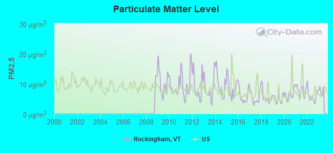
Particulate Matter (PM2.5) [µg/m3] level in 2022 was 5.97. This is better than average. Closest monitor was 15.5 miles away from the city center.
| City: | 5.97 |
| U.S.: | 8.11 |
Tornado activity:
Rockingham-area historical tornado activity is significantly above Vermont state average. It is 41% smaller than the overall U.S. average.
On 8/20/1968, a category F3 (max. wind speeds 158-206 mph) tornado 16.7 miles away from the Rockingham town center injured one person and caused between $5000 and $50,000 in damages.
On 6/9/1953, a category F4 (max. wind speeds 207-260 mph) tornado 50.7 miles away from the town center killed 90 people and injured 1228 people and caused between $50,000,000 and $500,000,000 in damages.
Earthquake activity:
Rockingham-area historical earthquake activity is significantly above Vermont state average. It is 70% smaller than the overall U.S. average.On 10/7/1983 at 10:18:46, a magnitude 5.3 (5.1 MB, 5.3 LG, 5.1 ML, Class: Moderate, Intensity: VI - VII) earthquake occurred 108.0 miles away from Rockingham center
On 4/20/2002 at 10:50:47, a magnitude 5.3 (5.3 ML, Depth: 3.0 mi) earthquake occurred 111.1 miles away from the city center
On 4/20/2002 at 10:50:47, a magnitude 5.2 (5.2 MB, 4.2 MS, 5.2 MW, 5.0 MW) earthquake occurred 110.3 miles away from the city center
On 1/19/1982 at 00:14:42, a magnitude 4.7 (4.5 MB, 4.7 MD, 4.5 LG, Class: Light, Intensity: IV - V) earthquake occurred 50.0 miles away from Rockingham center
On 10/16/2012 at 23:12:25, a magnitude 4.7 (4.7 ML, Depth: 10.0 mi) earthquake occurred 96.5 miles away from the city center
On 6/17/1991 at 08:53:16, a magnitude 4.1 (4.0 MB, 4.0 LG, Depth: 3.1 mi) earthquake occurred 117.3 miles away from the city center
Magnitude types: regional Lg-wave magnitude (LG), body-wave magnitude (MB), duration magnitude (MD), local magnitude (ML), surface-wave magnitude (MS), moment magnitude (MW)
Natural disasters:
The number of natural disasters in Windham County (16) is near the US average (15).Major Disasters (Presidential) Declared: 13
Emergencies Declared: 2
Causes of natural disasters: Floods: 11, Storms: 10, Tropical Storms: 2, Hurricane: 1, Landslide: 1, Snowstorm: 1, Wind: 1, Winter Storm: 1 (Note: some incidents may be assigned to more than one category).
Amtrak stations near Rockingham:
- 3 miles: BELLOWS FALLS (DEPOT ST.) . Services: enclosed waiting area, public restrooms, public payphones, free short-term parking, free long-term parking, call for taxi service.
- 15 miles: CLAREMONT (PLAINS RD.) . Services: public payphones, free short-term parking, free long-term parking.
- 20 miles: OKEMO (LUDLOW, OKEMO MOUNTAIN) - Seasonal Bus Station
Colleges/universities with over 2000 students nearest to Rockingham:
- Keene State College (about 20 miles; Keene, NH; Full-time enrollment: 5,098)
- Franklin Pierce University (about 35 miles; Rindge, NH; FT enrollment: 2,139)
- Dartmouth College (about 39 miles; Hanover, NH; FT enrollment: 6,030)
- Castleton State College (about 47 miles; Castleton, VT; FT enrollment: 2,079)
- Mount Wachusett Community College (about 47 miles; Gardner, MA; FT enrollment: 3,143)
- NHTI-Concord's Community College (about 49 miles; Concord, NH; FT enrollment: 2,865)
- Williams College (about 49 miles; Williamstown, MA; FT enrollment: 2,141)
Points of interest:
Notable locations in Rockingham: Saxtons River Historical Society Building (A), Fish Ladder and New England Power Company Information Center (B), Old Fire House (C), Rockingham Town Hall (D), Rockingham Free Public Library (E), Great Falls Regional Chamber of Commerce (F), Polish American Club (G), Bellows Falls Historical Society Museum (H), Bellows Falls Fire Department (I), Saxtons River Volunteer Fire Department (J), Rockingham Fire Department (K), Lefevre Ambulance Incorporated (L), Bellows Falls Opera House (M). Display/hide their locations on the map
Churches in Rockingham include: United Church of Bellows Falls (A), Immanuel Episcopal Church (B), Saint Edmund of Canterbury Roman Catholic Church (C), Christ Church (D), First Baptist Church (E), Rockingham Meeting-House (F). Display/hide their locations on the map
Cemeteries: Wright-Bartonsville Cemetery (1), Williams River-Wright Cemetery (2), Saxtons River Cemetery (3), Rockingham Meeting-House Cemetery (4), Restland Cemetery (5), Oliver Lovell Cemetery (6), Immanuel Cemetery (7). Display/hide their locations on the map
Reservoir: Minards Pond (A). Display/hide its location on the map
Streams, rivers, and creeks: O'Brien Brook (A), Little Commissary Brook (B), Lily Brook (C), Williams River (D), Bull Creek (E), Weaver Brook (F). Display/hide their locations on the map
Parks in Rockingham include: Saxtons River Village Historic District (1), Bellows Falls Downtown Historic District (2). Display/hide their locations on the map
Birthplace of: George O. Proctor - Politician, S. S. Davis - Politician, Zera Pulsipher - Mormon missionary.
| This town: | 2.3 people |
| Vermont: | 2.3 people |
| This town: | 59.9% |
| Whole state: | 62.5% |
| This town: | 10.3% |
| Whole state: | 9.2% |
Likely homosexual households (counted as self-reported same-sex unmarried-partner households)
- Lesbian couples: 0.9% of all households
- Gay men: 0.8% of all households
| This town: | 10.0% |
| Whole state: | 9.4% |
| This town: | 3.5% |
| Whole state: | 3.6% |
People in group quarters in Rockingham in 2010:
- 60 people in other noninstitutional facilities
- 36 people in workers' group living quarters and job corps centers
- 34 people in residential treatment centers for adults
- 28 people in nursing facilities/skilled-nursing facilities
- 6 people in emergency and transitional shelters (with sleeping facilities) for people experiencing homelessness
19 people in other group homes in 2000
For population 15 years and over in Rockingham:
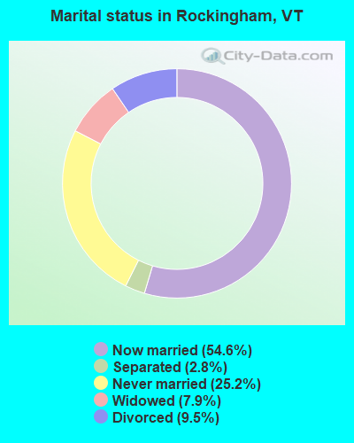
- Never married: 25.2%
- Now married: 54.6%
- Separated: 2.8%
- Widowed: 7.9%
- Divorced: 9.5%
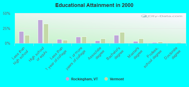
For population 25 years and over in Rockingham:
- High school or higher: 80.1%
- Bachelor's degree or higher: 18.7%
- Graduate or professional degree: 5.0%
- Unemployed: 5.5%
- Mean travel time to work (commute): 18.2 minutes
| Here: | 11.3 |
| Vermont average: | 11.7 |
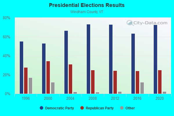
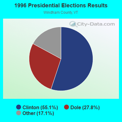
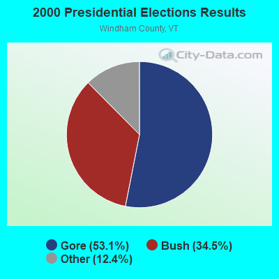
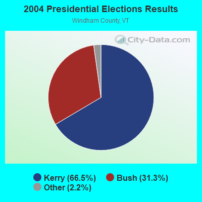
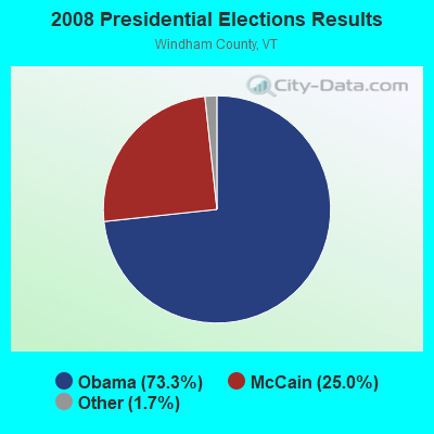

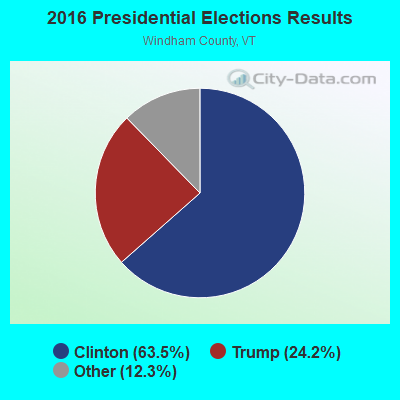
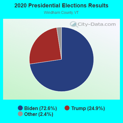
Graphs represent county-level data. Detailed 2008 Election Results
Religion statistics for Rockingham, VT (based on Windham County data)
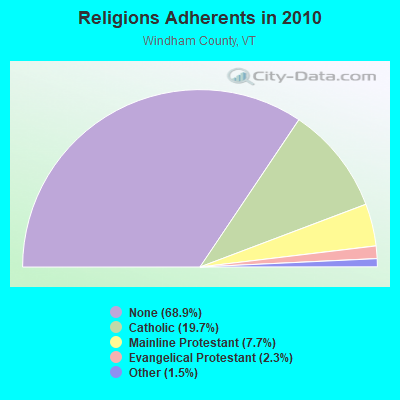
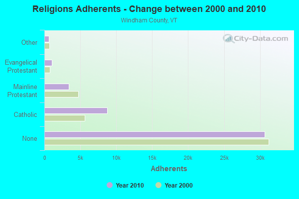
| Religion | Adherents | Congregations |
|---|---|---|
| Catholic | 8,753 | 8 |
| Mainline Protestant | 3,412 | 38 |
| Evangelical Protestant | 1,026 | 13 |
| Other | 647 | 12 |
| None | 30,675 | - |
Food Environment Statistics:
| This county: | 4.14 / 10,000 pop. |
| State: | 3.84 / 10,000 pop. |
| Here: | 1.38 / 10,000 pop. |
| Vermont: | 1.95 / 10,000 pop. |
| Here: | 7.37 / 10,000 pop. |
| State: | 6.40 / 10,000 pop. |
| Windham County: | 18.87 / 10,000 pop. |
| State: | 11.52 / 10,000 pop. |
| Windham County: | 6.7% |
| Vermont: | 6.8% |
| Windham County: | 22.6% |
| Vermont: | 22.3% |
| Windham County: | 12.5% |
| State: | 13.3% |
Strongest AM radio stations in Rockingham:
- WNBX (1480 AM; 5 kW; SPRINGFIELD, VT)
- WNTK (1020 AM; 10 kW; NEWPORT, NH; Owner: KOOR COMMUNICATIONS, INC.)
- WNNZ (640 AM; 50 kW; WESTFIELD, MA; Owner: CLEAR CHANNEL BROADCASTING LICENSES, INC.)
- WKBK (1290 AM; 5 kW; KEENE, NH; Owner: SAGA COMMUNICATIONS OF NEW ENGLAND, LLC)
- WCRN (830 AM; 50 kW; WORCESTER, MA; Owner: CARTER BROADCASTING CORPORATION)
- WRKO (680 AM; 50 kW; BOSTON, MA; Owner: ENTERCOM BOSTON LICENSE, LLC)
- WGY (810 AM; 50 kW; SCHENECTADY, NY; Owner: CLEAR CHANNEL BROADCASTING LICENSES, INC.)
- WEEI (850 AM; 50 kW; BOSTON, MA; Owner: ENTERCOM BOSTON LICENSE, LLC)
- WVNE (760 AM; daytime; 25 kW; LEICESTER, MA; Owner: BLOUNT MASSCOM, INC.)
- WKOX (1200 AM; 50 kW; FRAMINGHAM, MA; Owner: CAPSTAR TX LIMITED PARTNERSHIP)
- WBIX (1060 AM; 40 kW; NATICK, MA; Owner: LANGER BROADCASTING CORPORATION)
- WPTR (1540 AM; 50 kW; ALBANY, NY; Owner: KIMTRON, INC.)
- WALE (990 AM; 50 kW; GREENVILLE, RI; Owner: NORTH AMERICAN BROADCASTING CO., INC.)
Strongest FM radio stations in Rockingham:
- WCFR-FM (96.3 FM; WALPOLE, NH; Owner: GREAT NORTHERN RADIO, LLC)
- WHDQ (106.1 FM; CLAREMONT, NH; Owner: GREAT NORTHERN RADIO, L.L.C.)
- WVPR (89.5 FM; WINDSOR, VT; Owner: VERMONT PUBLIC RADIO)
- WKNE (103.7 FM; KEENE, NH; Owner: SAGA COMMUNICATIONS OF NEW ENGLAND, LLC)
- WEVN (90.7 FM; KEENE, NH; Owner: NEW HAMPSHIRE PUBLIC RADIO, INC.)
- WZSH (107.1 FM; BELLOWS FALLS, VT; Owner: GREAT NORTHERN RADIO, L.L.C.)
- WEQX (102.7 FM; MANCHESTER, VT; Owner: NORTHSHIRE COMMUNICATIONS, INC.)
- WJAN (95.1 FM; SUNDERLAND, VT; Owner: 6 JOHNSON ROAD LICENSES, INC.)
- WVRR (101.7 FM; NEWPORT, NH; Owner: CAPSTAR TX LIMITED PARTNERSHIP)
- WJJR (98.1 FM; RUTLAND, VT; Owner: 6 JOHNSON ROAD LICENSES, INC.)
- WZRT (97.1 FM; RUTLAND, VT; Owner: CAPSTAR TX LIMITED PARTNERSHIP)
- WCMK (91.9 FM; PUTNEY, VT; Owner: CHRISTIAN MINISTRIES INC)
- WXKK (93.5 FM; SPRINGFIELD, VT; Owner: CLEAR CHANNEL BROADCASTING LICENSES, INC.)
- WEBK (105.3 FM; KILLINGTON, VT; Owner: 6 JOHNSON ROAD LICENSES, INC.)
- WVAY (100.7 FM; WILMINGTON, VT; Owner: GREAT NORTHERN RADIO, L.L.C.)
- WGLV (91.7 FM; WOODSTOCK, VT; Owner: CHRISTIAN MINISTRIES INC)
- WHDQ-FM1 (106.1 FM; RUTLAND, VT; Owner: GREAT NORTHERN RADIO, L.L.C.)
- WFEX (92.1 FM; PETERBOROUGH, NH; Owner: FNX BROADCASTING OF NEW HAMPSHIRE LLC)
- W293AB (106.5 FM; KEENE, NH; Owner: GREAT NORTHERN RADIO, L.L.C.)
- WKVT-FM (92.7 FM; BRATTLEBORO, VT; Owner: SAGA COMMUNICATIONS OF NEW ENGLAND, LLC)
TV broadcast stations around Rockingham:
- WEKW-TV (Channel 52; KEENE, NH; Owner: UNIVERSITY OF NEW HAMPSHIRE)
- WVTA (Channel 41; WINDSOR, VT; Owner: VERMONT ETV, INC.)
- WNNE (Channel 31; HARTFORD, VT; Owner: HEARST-ARGYLE STATIONS, INC.)
- W17CI (Channel 17; CLAREMONT, NH; Owner: UPPER VALLEY BROADCASTING, LLC)
Medal of Honor Recipients
Medal of Honor Recipient born in Rockingham: Frank G. Butterfield.
- National Bridge Inventory (NBI) Statistics
- 24Number of bridges
- 453ft / 138mTotal length
- $30,282,000Total costs
- 144,261Total average daily traffic
- 16,762Total average daily truck traffic
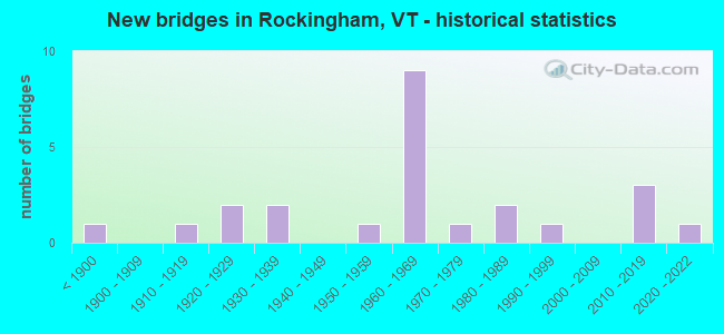
- New bridges - historical statistics
- 1Before 1900
- 11910-1919
- 21920-1929
- 21930-1939
- 11950-1959
- 91960-1969
- 11970-1979
- 21980-1989
- 11990-1999
- 32010-2019
- 12020-2022
FCC Registered Broadcast Land Mobile Towers:
7- Fire Station Rt 103 (Lat: 43.200917 Lon: -72.506750), Call Sign: KUQ898,
Assigned Frequencies: 154.430 MHz, Grant Date: 09/03/2011, Expiration Date: 11/15/2021, Cancellation Date: 02/23/2022, Registrant: Southwestern Nh District Fire Mutual Aid, 32 Vernon Street, Keene, NH 03431, Phone: (603) 352-8635, Fax: (603) 357-1985, Email:
- Rockingham St Hwy Garage (Lat: 44.187556 Lon: -72.482333), Call Sign: WLR96,
Assigned Frequencies: 151.070 MHz, Grant Date: 05/05/2021, Expiration Date: 07/31/2031, Registrant: State Of Vermont, 45 State Drive, Watterbury, VT 05671, Phone: (802) 229-0882, Fax: (802) 241-5557, Email:
- Rockingham Tool Shed Rt 103 (Lat: 43.178139 Lon: -72.489806), Call Sign: KFV816,
Assigned Frequencies: 39.1000 MHz, Grant Date: 04/09/2015, Expiration Date: 06/26/2025, Registrant: Swnh District Fire Mutual Aid, Keene, NH 03431, Phone: (603) 352-8635, Fax: (603) 357-1985, Email:
- Tool Shed (Lat: 43.200917 Lon: -72.506750), Call Sign: KVF816,
Assigned Frequencies: 39.1000 MHz, Grant Date: 03/29/1996, Expiration Date: 04/11/2001, Cancellation Date: 06/17/2001, Registrant: Rockingham, Town Of, Rockingham St, Bellows Falls, VT 05101
- State Police District Headquarters (Lat: 43.178139 Lon: -72.459250), Call Sign: WAL272,
Assigned Frequencies: 465.100 MHz, Grant Date: 06/12/2014, Expiration Date: 07/24/2024, Registrant: State Of Vermont, 45 State Drive, Watterbury, VT 05671, Phone: (802) 229-0882, Fax: (802) 241-5557, Email:
- Chester Rd State Police Office (Lat: 43.178139 Lon: -72.459250), Call Sign: WGW33,
Assigned Frequencies: 465.025 MHz, Grant Date: 09/12/2015, Expiration Date: 11/21/2025, Registrant: State Of Vermont, 45 State Drive, Watterbury, VT 05671, Phone: (802) 229-0882, Fax: (802) 241-5557, Email:
- Fire Station Rt 103 (Lat: 43.200917 Lon: -72.506750), Call Sign: KNDD580,
Assigned Frequencies: 154.540 MHz, Grant Date: 10/19/2022, Expiration Date: 07/27/2032, Registrant: Swnh District Fire Mutual Aid, 32 Vernon St., Keene, NH 03431, Phone: (603) 352-8635, Fax: (603) 357-1985, Email:
FCC Registered Microwave Towers:
3- ROCKINGHAM, Approx. 0.14 Miles W Of The Int. Of Parker Hill Road And Osgood Road (Lat: 43.213444 Lon: -72.485139), Type: Upole, Structure height: 24.7 m, Overall height: 30.8 m, Call Sign: WQVG851,
Assigned Frequencies: 942.575 MHz, Grant Date: 02/09/2015, Expiration Date: 02/09/2025, Certifier: Phillip T Chitwood, Registrant: Vermont Transco LLC, 366 Pinnacle Ridge Road, Rutland, VT 05701, Phone: (802) 772-3777, Email:
- Rockingham, State Police Troop D Headqtrs (Lat: 43.227028 Lon: -72.540917), Type: Bant, Structure height: 4 m, Overall height: 5.2 m, Call Sign: KFG84,
Assigned Frequencies: 6825.00 MHz, Grant Date: 01/04/2018, Expiration Date: 03/04/2028, Registrant: State Of Vermont, 45 State Drive, Watterbury, VT 05671, Phone: (802) 229-0882, Fax: (802) 241-5557, Email:
- STATION, Bellows Falls Hydroelectric Station Off Bridge St (Lat: 43.132833 Lon: -72.441750), Structure height: 9.8 m, Overall height: 18.9 m, Call Sign: KZW79,
Assigned Frequencies: 6805.00 MHz, Grant Date: 05/26/2012, Expiration Date: 07/23/2022, Cancellation Date: 08/31/2017, Registrant: Utilties Telecom Council, 1129 20th Street Nw, Suite 350, Washington, DC 20036, Phone: (202) 872-0030, Fax: (202) 872-1331, Email:
FAA Registered Aircraft:
1- Aircraft: EXTRA-FLUGZEUGBAU GMBH 300/S (Category: Land, Seats: 2, Weight: Up to 12,499 Pounds), Engine: Reciprocating
N-Number: 76PK, N76PK, N-76PK, Serial Number: 15, Airworthiness Date: 02/18/1998, Certificate Issue Date: 03/20/2018
Registrant (Individual): Charles W Schumacher, 288 Cambridgeport Rd, Rockingham, VT 05143
2002 - 2018 National Fire Incident Reporting System (NFIRS) incidents
- Fire incident types reported to NFIRS in Rockingham, VT
- 9153.8%Structure Fires
- 4224.9%Outside Fires
- 2414.2%Mobile Property/Vehicle Fires
- 127.1%Other
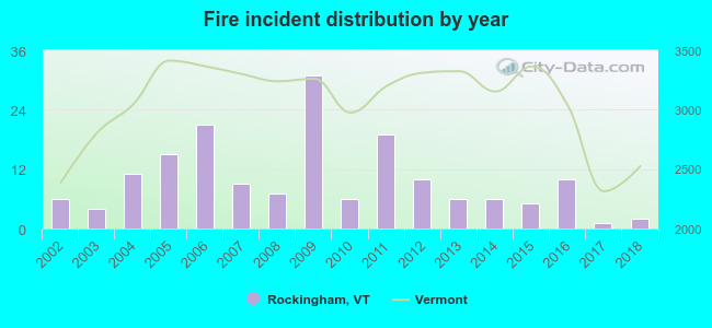 According to the data from the years 2002 - 2018 the average number of fire incidents per year is 10. The highest number of reported fires - 31 took place in 2009, and the least - 1 in 2017. The data has a declining trend.
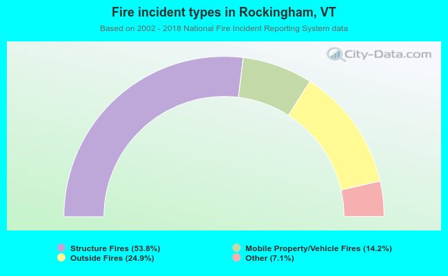 When looking into fire subcategories, the most incidents belonged to: Structure Fires (53.8%), and Outside Fires (24.9%).
- 82.8%Fuel oil, kerosene, etc.
- 10.3%Wood
- 4.7%Bottled, tank, or LP gas
- 2.2%Electricity
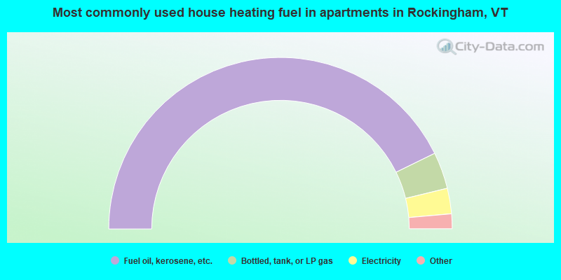
- 85.4%Fuel oil, kerosene, etc.
- 6.9%Bottled, tank, or LP gas
- 4.8%Electricity
- 1.4%Utility gas
- 1.1%Wood
- 0.3%Other fuel
Rockingham compared to Vermont state average:
- Unemployed percentage below state average.
- Foreign-born population percentage below state average.
- Length of stay since moving in significantly above state average.
- Number of rooms per house significantly below state average.
- House age significantly below state average.
- Number of college students below state average.
- Percentage of population with a bachelor's degree or higher below state average.
Rockingham on our top lists:
- #1 on the list of "Top 101 cities with largest percentage of males in industries: fuel dealers (population 5,000+)"
- #3 on the list of "Top 101 cities with largest percentage of males in industries: groceries and related products merchant wholesalers (population 5,000+)"
- #11 on the list of "Top 101 cities with largest percentage of males in occupations: secondary school teachers (population 5,000+)"
- #13 on the list of "Top 101 cities with largest percentage of males in occupations: printing workers (population 5,000+)"
- #14 on the list of "Top 101 cities with largest percentage of females in occupations: laborers and material movers, hand (population 5,000+)"
- #26 on the list of "Top 101 cities with largest percentage of males in industries: petroleum and petroleum products merchant wholesalers (population 5,000+)"
- #31 on the list of "Top 101 cities with largest percentage of males in occupations: nursing, psychiatric, and home health aides (population 5,000+)"
- #32 on the list of "Top 101 cities with largest percentage of males in occupations: driver/sales workers and truck drivers (population 5,000+)"
- #37 on the list of "Top 101 cities with largest percentage of females in industries: wood products (population 5,000+)"
- #38 on the list of "Top 101 cities with largest percentage of females in occupations: metal workers and plastic workers (population 5,000+)"
- #40 on the list of "Top 101 cities with largest percentage of females in industries: machinery (population 5,000+)"
- #43 on the list of "Top 101 cities with largest percentage of females in industries: motor vehicles, parts and supplies merchant wholesalers (population 5,000+)"
- #46 on the list of "Top 101 cities with largest percentage of males in industries: printing and related support activities (population 5,000+)"
- #52 on the list of "Top 101 cities with largest percentage of males in industries: book stores and news dealers (population 5,000+)"
- #54 on the list of "Top 101 cities with largest percentage of males in industries: recyclable material merchant wholesalers (population 5,000+)"
- #71 on the list of "Top 101 cities with largest percentage of females in industries: furniture and related product manufacturing (population 5,000+)"
- #72 on the list of "Top 101 cities with the largest percentage of likely homosexual households (counted as self-reported same-sex unmarried-partner households) (population 5,000+)"
- #73 on the list of "Top 101 cities with largest percentage of males in industries: used merchandise, gift, novelty, and souvenir, and other miscellaneous stores (population 5,000+)"
- #76 on the list of "Top 101 cities with largest percentage of females in industries: u. s. postal service (population 5,000+)"
- #81 on the list of "Top 101 cities with largest percentage of males in industries: furniture and home furnishing merchant wholesalers (population 5,000+)"

|
Total of 3 patent applications in 2008-2024.