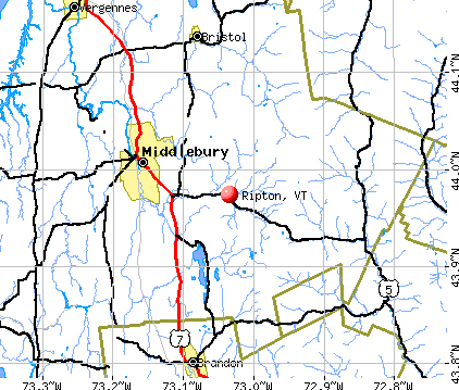
Ripton, Vermont
Submit your own pictures of this town and show them to the world
- OSM Map
- General Map
- Google Map
- MSN Map
Population change since 2000: +5.8%
 |
| Males: 298 | |
| Females: 290 |
| Median resident age: | 46.2 years |
| Vermont median age: | 45.8 years |
Zip codes: 05766.
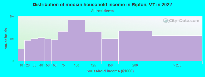
| Ripton: | $78,762 |
| VT: | $73,991 |
Estimated per capita income in 2022: $42,977 (it was $19,597 in 2000)
Ripton town income, earnings, and wages data
Estimated median house or condo value in 2022: $339,713 (it was $113,400 in 2000)
| Ripton: | $339,713 |
| VT: | $304,700 |
Mean prices in 2022: all housing units: $400,302; detached houses: $427,258; townhouses or other attached units: $389,241; in 2-unit structures: $373,341; in 3-to-4-unit structures: $633,103; in 5-or-more-unit structures: $292,995; mobile homes: $101,709
Detailed information about poverty and poor residents in Ripton, VT
Compare current foreclosures near Ripton, VT:
| Photo | Address | Area | Beds / Baths | Price | Details |
|---|---|---|---|---|---|

|
#1
Pine St # 4
Bristol, VT 05443
|
- sq. feet
|
- baths - beds |
show details | |

|
#2
N Meadow Dr
Bristol, VT 05443
|
- sq. feet
|
- baths - beds |
show details | |

|
#3
Cuttinghill Rd
Whiting, VT 05778
|
- sq. feet
|
- baths - beds |
show details | |

|
#4
Rabbit Hollow Rd
Northfield, VT 05663
|
- sq. feet
|
- baths - beds |
show details | |

|
#5
Leicester Whiting Rd
Whiting, VT 05778
|
- sq. feet
|
- baths - beds |
show details | |

|
#6
Rattlin Bridge Rd
Bridport, VT 05734
|
- sq. feet
|
- baths - beds |
show details | |

|
#7
Plank Rd
Vergennes, VT 05491
|
- sq. feet
|
- baths - beds |
show details | |

|
#8
Eagles Rd
Waitsfield, VT 05673
|
- sq. feet
|
- baths - beds |
show details | |

|
#9
Hardscrabble Rd
Bristol, VT 05443
|
- sq. feet
|
- baths - beds |
show details | |

|
Check over 1 million property listings on Foreclosure.com!
|
browse all offers | |||

- 56495.9%White alone
- 122.0%Two or more races
- 71.2%Hispanic
- 40.7%Asian alone
- 10.2%American Indian alone
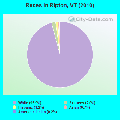
Races in Ripton detailed stats: ancestries, foreign born residents, place of birth
 Recent articles from our blog. Our writers, many of them Ph.D. graduates or candidates, create easy-to-read articles on a wide variety of topics.

 | Which larger towns have the most hikes nearby? (12 replies) |
| Living Near Middlebury - Things to consider? (3 replies) |
| Visit Green Mountain National Forest: Questions (7 replies) |
| Mad River Valley? Questions on possible relocation... (30 replies) |
| Fall color/colour (4 replies) |
| Best nordic skiing near(ish) Burlington? (2 replies) |
Latest news from Ripton, VT collected exclusively by city-data.com from local newspapers, TV, and radio stations
Ancestries: English (24.6%), Irish (21.6%), German (12.2%), French (8.8%), Scottish (7.4%), French Canadian (7.2%).
Current Local Time: EST time zone
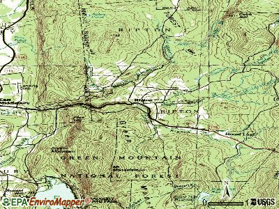
Elevation: 1058 feet
Land area: 49.5 square miles.
Population density: 12 people per square mile (very low).
11 residents are foreign born
| This town: | 2.0% |
| Vermont: | 3.8% |
| Ripton town: | 2.1% ($2,385) |
| Vermont: | 2.0% ($2,196) |
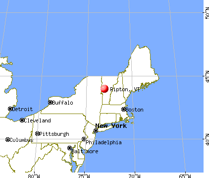
Nearest city with pop. 50,000+: Schenectady, NY  (93.5 miles , pop. 61,821).
Nearest city with pop. 200,000+: Boston, MA (150.4 miles , pop. 589,141).
Nearest city with pop. 1,000,000+: Bronx, NY (221.2 miles , pop. 1,332,650).
Nearest cities:
), ), ), ), ), )Latitude: 43.98 N, Longitude: 73.02 W
Area code commonly used in this area: 802

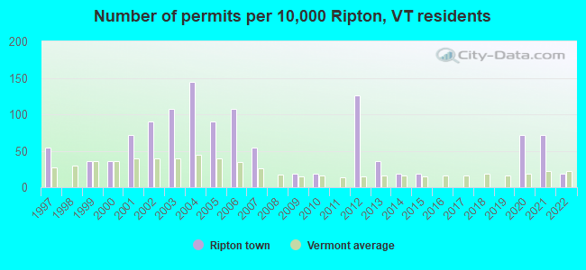
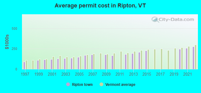
Single-family new house construction building permits:
- 2022: 1 building, cost: $279,200
- 2021: 4 buildings, average cost: $259,200
- 2020: 4 buildings, average cost: $248,200
- 2015: 1 building, cost: $226,800
- 2014: 1 building, cost: $211,200
- 2013: 2 buildings, average cost: $193,300
- 2012: 7 buildings, average cost: $184,000
- 2010: 1 building, cost: $165,900
- 2009: 1 building, cost: $178,900
- 2007: 3 buildings, average cost: $181,200
- 2006: 6 buildings, average cost: $171,000
- 2005: 5 buildings, average cost: $150,200
- 2004: 8 buildings, average cost: $138,800
- 2003: 6 buildings, average cost: $132,800
- 2002: 5 buildings, average cost: $130,700
- 2001: 4 buildings, average cost: $121,400
- 2000: 2 buildings, average cost: $118,000
- 1999: 2 buildings, average cost: $109,200
- 1997: 3 buildings, average cost: $91,700
| Here: | 0.8% |
| Vermont: | 2.0% |
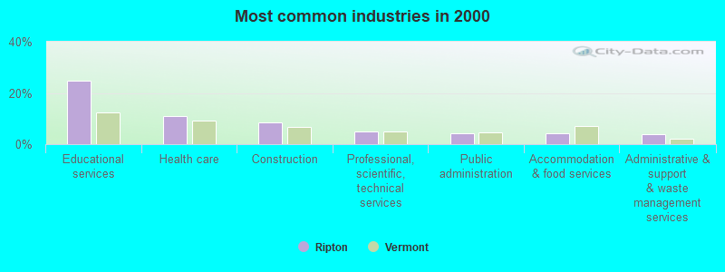
- Educational services (24.8%)
- Health care (10.8%)
- Construction (8.4%)
- Professional, scientific, technical services (5.0%)
- Public administration (4.3%)
- Accommodation & food services (4.3%)
- Administrative & support & waste management services (4.0%)
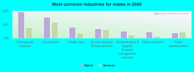
- Educational services (19.3%)
- Construction (15.3%)
- Health care (8.0%)
- Accommodation & food services (6.8%)
- Administrative & support & waste management services (5.1%)
- Wood products (4.5%)
- Public administration (4.0%)
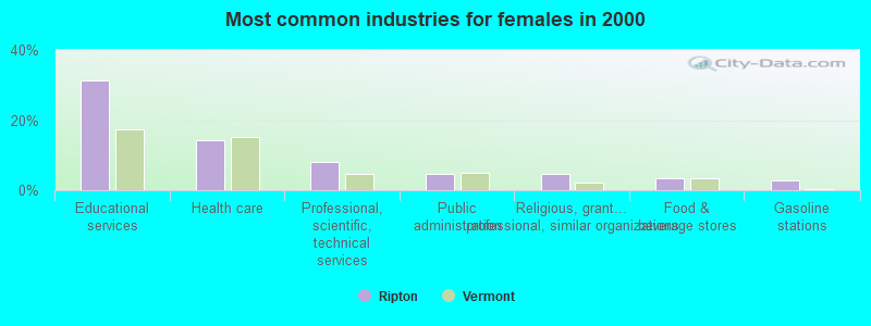
- Educational services (31.3%)
- Health care (14.3%)
- Professional, scientific, technical services (8.2%)
- Public administration (4.8%)
- Religious, grantmaking, civic, professional, similar organizations (4.8%)
- Food & beverage stores (3.4%)
- Gasoline stations (2.7%)
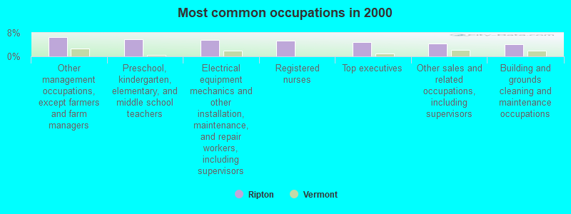
- Other management occupations, except farmers and farm managers (6.5%)
- Preschool, kindergarten, elementary, and middle school teachers (5.9%)
- Electrical equipment mechanics and other installation, maintenance, and repair workers, including supervisors (5.6%)
- Registered nurses (5.3%)
- Top executives (5.0%)
- Other sales and related occupations, including supervisors (4.3%)
- Building and grounds cleaning and maintenance occupations (4.0%)
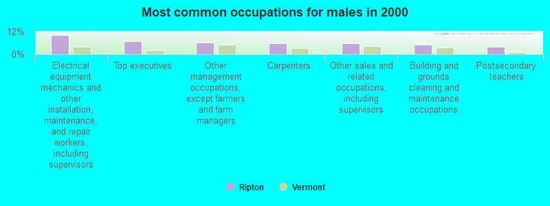
- Electrical equipment mechanics and other installation, maintenance, and repair workers, including supervisors (10.2%)
- Top executives (6.8%)
- Other management occupations, except farmers and farm managers (6.2%)
- Carpenters (5.7%)
- Other sales and related occupations, including supervisors (5.7%)
- Building and grounds cleaning and maintenance occupations (5.1%)
- Postsecondary teachers (4.0%)
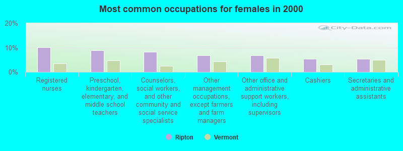
- Registered nurses (10.2%)
- Preschool, kindergarten, elementary, and middle school teachers (8.8%)
- Counselors, social workers, and other community and social service specialists (8.2%)
- Other management occupations, except farmers and farm managers (6.8%)
- Other office and administrative support workers, including supervisors (6.8%)
- Cashiers (5.4%)
- Secretaries and administrative assistants (5.4%)
Average climate in Ripton, Vermont
Based on data reported by over 4,000 weather stations


Earthquake activity:
Ripton-area historical earthquake activity is significantly above Vermont state average. It is 70% smaller than the overall U.S. average.On 4/20/2002 at 10:50:47, a magnitude 5.3 (5.3 ML, Depth: 3.0 mi, Class: Moderate, Intensity: VI - VII) earthquake occurred 49.9 miles away from Ripton center
On 10/7/1983 at 10:18:46, a magnitude 5.3 (5.1 MB, 5.3 LG, 5.1 ML) earthquake occurred 66.1 miles away from Ripton center
On 4/20/2002 at 10:50:47, a magnitude 5.2 (5.2 MB, 4.2 MS, 5.2 MW, 5.0 MW) earthquake occurred 49.3 miles away from the city center
On 1/19/1982 at 00:14:42, a magnitude 4.7 (4.5 MB, 4.7 MD, 4.5 LG, Class: Light, Intensity: IV - V) earthquake occurred 78.2 miles away from Ripton center
On 10/16/2012 at 23:12:25, a magnitude 4.7 (4.7 ML, Depth: 10.0 mi) earthquake occurred 120.8 miles away from the city center
On 6/16/1995 at 12:13:11, a magnitude 3.8 (3.8 LG, Depth: 3.1 mi, Class: Light, Intensity: II - III) earthquake occurred 58.5 miles away from the city center
Magnitude types: regional Lg-wave magnitude (LG), body-wave magnitude (MB), duration magnitude (MD), local magnitude (ML), surface-wave magnitude (MS), moment magnitude (MW)
Natural disasters:
The number of natural disasters in Addison County (23) is greater than the US average (15).Major Disasters (Presidential) Declared: 16
Emergencies Declared: 3
Causes of natural disasters: Floods: 16, Storms: 15, Drought: 1, Heavy Rain: 1, Hurricane: 1, Ice Storm: 1, Landslide: 1, Snow: 1, Snowstorm: 1, Tornado: 1, Tropical Storm: 1, Wind: 1, Winter Storm: 1, Other: 1 (Note: some incidents may be assigned to more than one category).
Colleges/universities with over 2000 students nearest to Ripton:
- Middlebury College (about 9 miles; Middlebury, VT; Full-time enrollment: 3,077)
- Norwich University (about 21 miles; Northfield, VT; FT enrollment: 4,221)
- Castleton State College (about 28 miles; Castleton, VT; FT enrollment: 2,079)
- Champlain College (about 36 miles; Burlington, VT; FT enrollment: 2,623)
- University of Vermont (about 36 miles; Burlington, VT; FT enrollment: 11,566)
- Saint Michael's College (about 37 miles; Colchester, VT; FT enrollment: 2,336)
- Community College of Vermont (about 37 miles; Winooski, VT; FT enrollment: 3,394)
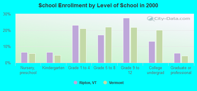
Private high school in Ripton:
Public elementary/middle school in Ripton:
- RIPTON ELEMENTARY SCHOOL (Students: 68, Location: 753 LINCOLN ROAD, Grades: PK-6)
Points of interest:
Notable locations in Ripton: Skylight Lodge (A), Camp Charidan (B), Silver Towers Camp (C), Emily Proctor Shelter (D), Robert Frost Wayside (E), Silver Towers Camp (F), Ripton Fire Department (G). Display/hide their locations on the map
Cemeteries: Gea Cemetery (1), Kirby Cemetery (2), Saint Therese Cemetery (3), Cooks Cemetery (4), Gee Cemetery (5), Cushman Cemetery (6), Galvin Cemetery (7). Display/hide their locations on the map
Lakes and swamps: Abbey Pond (A), Skylight Pond (B), Beaver Meadow (C). Display/hide their locations on the map
Streams, rivers, and creeks: Dragon Brook (A), Crystal Brook (B), Sparks Brook (C), South Branch Middlebury River (D), Brandy Brook (E), Gonya Brook (F), Alder Brook (G), Fire Brook (H), Middle Branch Middlebury River (I). Display/hide their locations on the map
Park in Ripton: Robert Frost Wayside (1). Display/hide its location on the map
Drinking water stations with addresses in Ripton and their reported violations in the past:
RIPTON ELEMENTARY SCHOOL (Population served: 75, Groundwater):Past health violations:NORTH BRANCH SCHOOL (Population served: 31, Groundwater):Past monitoring violations:
- MCL, Acute (TCR) - In JAN-2014, Contaminant: Coliform. Follow-up actions: St Tech Assistance Visit (JAN-23-2014), St Formal NOV issued (JAN-23-2014), St Public Notif received (JAN-23-2014), St Public Notif requested (JAN-23-2014), St Boil Water Order (JAN-23-2014), St Compliance achieved (FEB-11-2014)
- MCL, Monthly (TCR) - Between JUL-2010 and SEP-2010, Contaminant: Coliform. Follow-up actions: St Public Notif requested (JUL-13-2010), St Formal NOV issued (JUL-13-2010), St Public Notif received (JUL-15-2010), St Compliance achieved (MAY-19-2011)
- Follow-up Or Routine LCR Tap M/R - In JAN-01-1997, Contaminant: Lead and Copper Rule. Follow-up actions: St Violation/Reminder Notice (JUL-01-1997), St Compliance achieved (MAR-16-2011)
- 2 routine major monitoring violations
- 38 regular monitoring violations
Past monitoring violations:
- Initial Tap Sampling for Pb and Cu - In JUL-01-2006, Contaminant: Lead and Copper Rule. Follow-up actions: St Public Notif requested (AUG-28-2006), St Formal NOV issued (AUG-28-2006), St Public Notif received (SEP-25-2006), St Compliance achieved (APR-26-2011)
- Follow-up Or Routine LCR Tap M/R - In APR-01-2004, Contaminant: Lead and Copper Rule. Follow-up actions: St Public Notif requested (SEP-14-2004), St Formal NOV issued (SEP-14-2004), St Compliance achieved (APR-26-2011)
- One routine major monitoring violation
- 14 regular monitoring violations
| This town: | 2.2 people |
| Vermont: | 2.3 people |
| This town: | 61.2% |
| Whole state: | 62.5% |
| This town: | 14.1% |
| Whole state: | 9.2% |
Likely homosexual households (counted as self-reported same-sex unmarried-partner households)
- Lesbian couples: 1.1% of all households
- Gay men: 0.4% of all households
| This town: | 15.6% |
| Whole state: | 9.4% |
| This town: | 4.9% |
| Whole state: | 3.6% |
For population 15 years and over in Ripton:
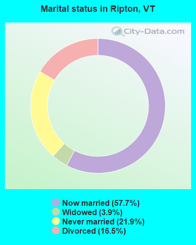
- Never married: 21.9%
- Now married: 57.7%
- Separated: 0.0%
- Widowed: 3.9%
- Divorced: 16.5%
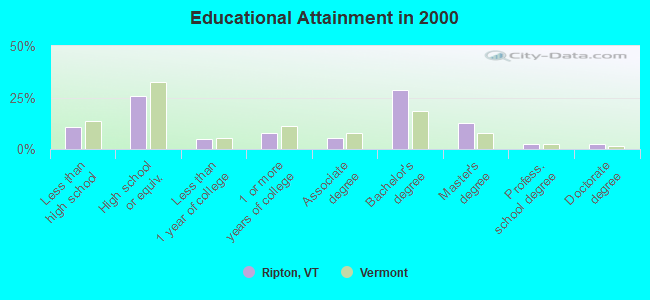
For population 25 years and over in Ripton:
- High school or higher: 89.4%
- Bachelor's degree or higher: 45.8%
- Graduate or professional degree: 17.1%
- Unemployed: 8.2%
- Mean travel time to work (commute): 25.5 minutes
| Here: | 10.5 |
| Vermont average: | 11.7 |
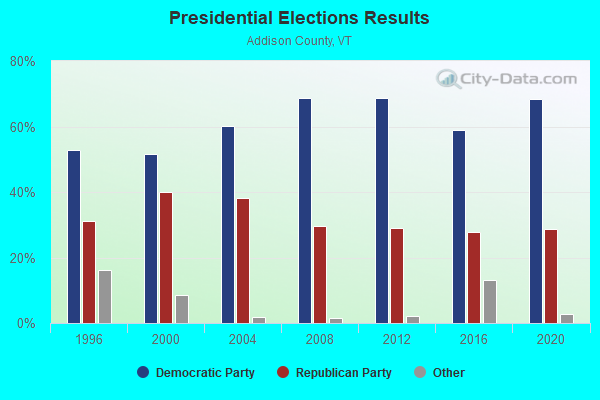
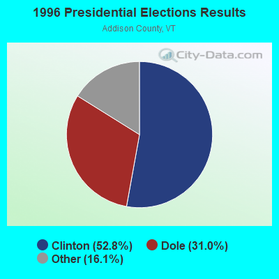

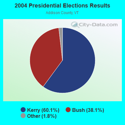
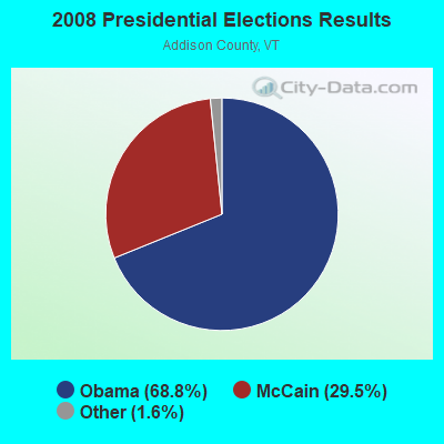
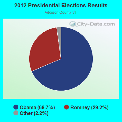
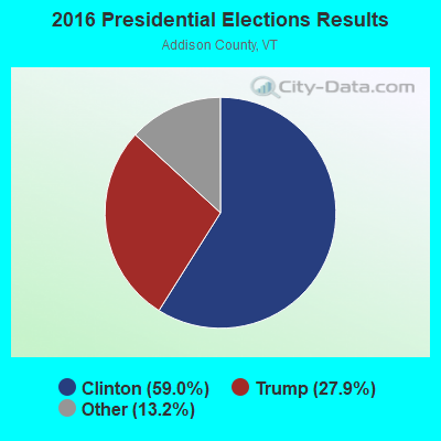
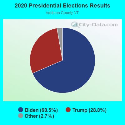
Graphs represent county-level data. Detailed 2008 Election Results
Religion statistics for Ripton, VT (based on Addison County data)
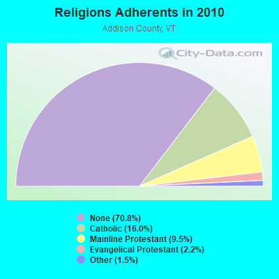
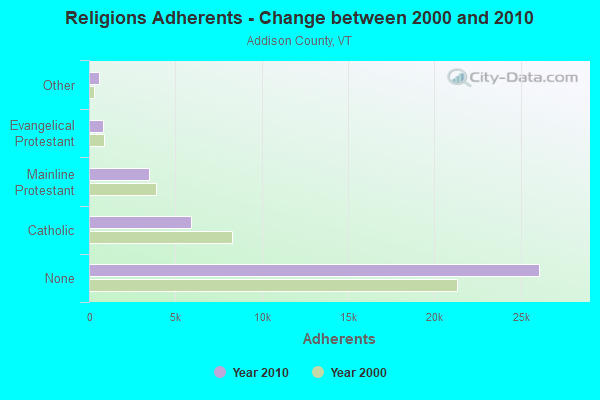
| Religion | Adherents | Congregations |
|---|---|---|
| Catholic | 5,892 | 6 |
| Mainline Protestant | 3,491 | 27 |
| Evangelical Protestant | 801 | 13 |
| Other | 560 | 6 |
| None | 26,077 | - |
Food Environment Statistics:
| Here: | 4.64 / 10,000 pop. |
| Vermont: | 3.84 / 10,000 pop. |
| Addison County: | 1.36 / 10,000 pop. |
| Vermont: | 1.95 / 10,000 pop. |
| Here: | 6.55 / 10,000 pop. |
| Vermont: | 6.40 / 10,000 pop. |
| This county: | 8.45 / 10,000 pop. |
| Vermont: | 11.52 / 10,000 pop. |
| Addison County: | 5.8% |
| State: | 6.8% |
| Addison County: | 20.9% |
| State: | 22.3% |
| Addison County: | 9.1% |
| Vermont: | 13.3% |
Strongest AM radio stations in Ripton:
- WFAD (1490 AM; 1 kW; MIDDLEBURY, VT; Owner: ADDISON BROADCASTING COMPANY, INC.)
- WDEV (550 AM; 5 kW; WATERBURY, VT; Owner: RADIO VERMONT, INC.)
- WCHP (760 AM; 35 kW; CHAMPLAIN, NY; Owner: CHAMPLAIN RADIO, INC.)
- WGY (810 AM; 50 kW; SCHENECTADY, NY; Owner: CLEAR CHANNEL BROADCASTING LICENSES, INC.)
- WSYB (1380 AM; 5 kW; RUTLAND, VT; Owner: CAPSTAR TX LIMITED PARTNERSHIP)
- WVMT (620 AM; 5 kW; BURLINGTON, VT; Owner: SISON BROADCASTING, INC.)
- WNNZ (640 AM; 50 kW; WESTFIELD, MA; Owner: CLEAR CHANNEL BROADCASTING LICENSES, INC.)
- WICY (1490 AM; 50 kW; MALONE, NY; Owner: CARTIER COMMUNICATIONS INC.)
- WRKO (680 AM; 50 kW; BOSTON, MA; Owner: ENTERCOM BOSTON LICENSE, LLC)
- WPTR (1540 AM; 50 kW; ALBANY, NY; Owner: KIMTRON, INC.)
- WCRN (830 AM; 50 kW; WORCESTER, MA; Owner: CARTER BROADCASTING CORPORATION)
- WNTK (1020 AM; 10 kW; NEWPORT, NH; Owner: KOOR COMMUNICATIONS, INC.)
- WVAA (1390 AM; 5 kW; BURLINGTON, VT; Owner: RADIO VERMONT, KDR, LLC)
Strongest FM radio stations in Ripton:
- WDEV-FM (96.1 FM; WARREN, VT; Owner: RADIO VERMONT, INC.)
- WWFY (100.9 FM; BERLIN, VT; Owner: VOX ALLEGANY, LLC)
- WEXP (101.5 FM; BRANDON, VT; Owner: VOX VERMONT, L.L.C.)
- WJEN (94.5 FM; RUTLAND, VT; Owner: 6 JOHNSON ROAD LICENSES, INC.)
- WEBK (105.3 FM; KILLINGTON, VT; Owner: 6 JOHNSON ROAD LICENSES, INC.)
- WJJR (98.1 FM; RUTLAND, VT; Owner: 6 JOHNSON ROAD LICENSES, INC.)
- WZRT (97.1 FM; RUTLAND, VT; Owner: CAPSTAR TX LIMITED PARTNERSHIP)
- WGLV (91.7 FM; WOODSTOCK, VT; Owner: CHRISTIAN MINISTRIES INC)
- WHDQ-FM1 (106.1 FM; RUTLAND, VT; Owner: GREAT NORTHERN RADIO, L.L.C.)
- WCVT (101.7 FM; STOWE, VT; Owner: RADIO VERMONT CLASSICS, L.L.C.)
- WNCS (104.7 FM; MONTPELIER, VT; Owner: MONTPELIER BROADCASTING, INC.)
- WVPS (107.9 FM; BURLINGTON, VT; Owner: VERMONT PUBLIC RADIO)
- WEZF (92.9 FM; BURLINGTON, VT; Owner: CAPSTAR TX LIMITED PARTNERSHIP)
- WLKC (103.3 FM; WATERBURY, VT; Owner: RADIO BROADCASTING SERVICES, INC.)
- WRMC-FM (91.1 FM; MIDDLEBURY, VT; Owner: THE PRESIDENT AND FELLOWS OF MIDDLEBURY COLLEGE)
- WVPR (89.5 FM; WINDSOR, VT; Owner: VERMONT PUBLIC RADIO)
- WGLY-FM (91.5 FM; BOLTON, VT; Owner: CHRISTIAN MINISTRIES, INC.)
- WEQX (102.7 FM; MANCHESTER, VT; Owner: NORTHSHIRE COMMUNICATIONS, INC.)
- WJAN (95.1 FM; SUNDERLAND, VT; Owner: 6 JOHNSON ROAD LICENSES, INC.)
- WHDQ (106.1 FM; CLAREMONT, NH; Owner: GREAT NORTHERN RADIO, L.L.C.)
TV broadcast stations around Ripton:
- W19BR (Channel 19; MONKTON, VT; Owner: PLATTSBURGH PARTNERS)
- WVER (Channel 28; RUTLAND, VT; Owner: VERMONT ETV, INC.)
- W25BT (Channel 25; MONKTON, VT; Owner: MOUNTAIN LAKES PUB.TELECOMM.COUNCIL)
Ripton fatal accident list:
Jul 15, 2005 01:25 PM, Sr-125, Lat: 43.974590, Lon: -73.043560, Vehicles: 2, Persons: 2, Fatalities: 1
Jul 9, 1976 07:35 AM, Vehicles: 1, Persons: 1, Fatalities: 1
Jul 9, 1975 07:35 AM, Vehicles: 1, Persons: 1, Fatalities: 1
- National Bridge Inventory (NBI) Statistics
- 11Number of bridges
- 49ft / 14.9mTotal length
- $1,220,000Total costs
- 5,238Total average daily traffic
- 269Total average daily truck traffic
- 5,501Total future (year 2027) average daily traffic
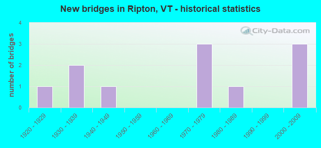
- New bridges - historical statistics
- 11920-1929
- 21930-1939
- 11940-1949
- 31970-1979
- 11980-1989
- 32000-2009
FCC Registered Broadcast Land Mobile Towers:
1- Water Tank (Lat: 43.961667 Lon: -72.978611), Type: Tank, Structure height: 9 m, Overall height: 10 m, Call Sign: WQNG342,
Assigned Frequencies: 173.203 MHz, Grant Date: 01/22/2021, Expiration Date: 01/27/2031, Certifier: Norman Cushman, Registrant: Bearcom, Po Box 559001, Dallas, TX 75355, Phone: (800) 458-9887, Email:
FCC Registered Microwave Towers:
4- Billings, Lat: 43.968111 Lon: -73.035472, Type: Tree, Structure height: 12 m, Call Sign: WQJR336,
Assigned Frequencies: 3650.00 MHz, Grant Date: 12/02/2008, Expiration Date: 12/02/2018, Cancellation Date: 02/16/2019, Certifier: Jeremy A Grip, Registrant: North Branch Networks, LLC, 10 Merchants Row Suite B104, Middlebury, VT 05753, Phone: (802) 382-8700, Fax: (802) 388-7156, Email:
- Brooks, Lat: 43.940556 Lon: -72.974528, Type: Building, Structure height: 6.5 m, Overall height: 6.9 m, Call Sign: WQJR336,
Assigned Frequencies: 3650.00 MHz, Grant Date: 12/02/2008, Expiration Date: 12/02/2018, Cancellation Date: 02/16/2019, Certifier: Jeremy A Grip, Registrant: North Branch Networks, LLC, 10 Merchants Row Suite B104, Middlebury, VT 05753, Phone: (802) 382-8700, Fax: (802) 388-7156, Email:
- Hanson, Lat: 43.983556 Lon: -73.033944, Type: Ltower, Structure height: 30.5 m, Overall height: 32.6 m, Call Sign: WQJR336,
Assigned Frequencies: 3650.00 MHz, Grant Date: 12/02/2008, Expiration Date: 12/02/2018, Cancellation Date: 02/16/2019, Certifier: Jeremy A Grip, Registrant: North Branch Networks, LLC, 10 Merchants Row Suite B104, Middlebury, VT 05753, Phone: (802) 382-8700, Fax: (802) 388-7156, Email:
- Biederman, Lat: 43.981139 Lon: -73.021083, Type: Building, Structure height: 10 m, Call Sign: WQJR336,
Assigned Frequencies: 3650.00 MHz, Grant Date: 12/02/2008, Expiration Date: 12/02/2018, Cancellation Date: 02/16/2019, Certifier: Jeremy A Grip, Registrant: North Branch Networks, LLC, 10 Merchants Row Suite B104, Middlebury, VT 05753, Phone: (802) 382-8700, Fax: (802) 388-7156, Email:
FCC Registered Amateur Radio Licenses:
4- Call Sign: N1FPR, Licensee ID: L00832044, Grant Date: 02/12/2014, Expiration Date: 05/10/2024, Certifier: Ross B Elliott, Registrant: Ross B Elliott, Ripton, VT 05766
- Call Sign: WB2GFU, Licensee ID: L00512554, Grant Date: 09/12/2018, Expiration Date: 11/19/2028, Certifier: Peter Karpak Jr, Registrant: Peter Karpak Jr, Ripton, VT 05766-0116
- Call Sign: WB4NIU, Licensee ID: L00973397, Grant Date: 02/24/2015, Expiration Date: 04/05/2025, Certifier: James M Kater, Registrant: James M Kater, Peddlars Bridge Rd, Ripton, VT 05766
- Call Sign: KB1TOH, Licensee ID: L01541379, Grant Date: 11/01/2019, Expiration Date: 01/14/2030, Certifier: Raven B Billings, Registrant: Raven B Billings, Po Box 131, Ripton, VT 05766
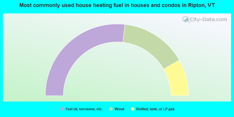
- 53.5%Fuel oil, kerosene, etc.
- 30.0%Wood
- 16.5%Bottled, tank, or LP gas
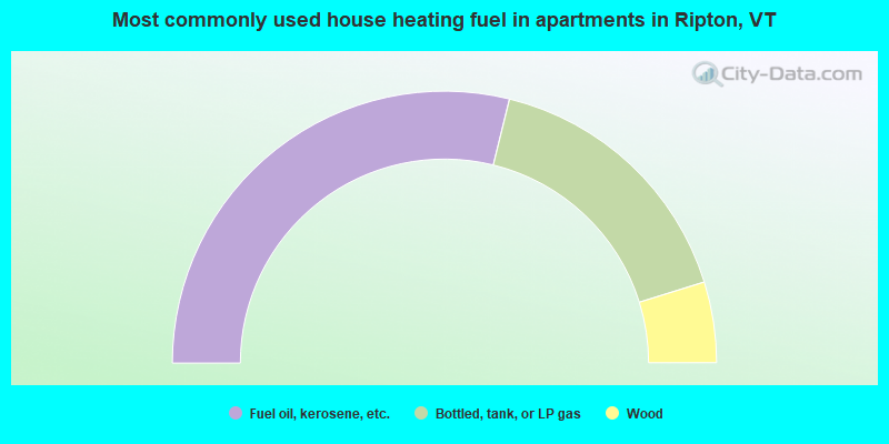
- 57.7%Fuel oil, kerosene, etc.
- 32.7%Bottled, tank, or LP gas
- 9.6%Wood
Ripton compared to Vermont state average:
- Black race population percentage significantly below state average.
- Hispanic race population percentage below state average.
- Foreign-born population percentage below state average.
- Renting percentage below state average.
- Length of stay since moving in significantly above state average.
- Number of rooms per house significantly below state average.
- House age significantly below state average.

|
Total of 2 patent applications in 2008-2024.