Pine Mountain, Kentucky
Submit your own pictures of this place and show them to the world
- OSM Map
- General Map
- Google Map
- MSN Map

| Males: 759 | |
| Females: 777 |
| Median resident age: | 35.7 years |
| Kentucky median age: | 35.9 years |
Zip code: 40810
| Pine Mountain: | $33,102 |
| KY: | $59,341 |
Estimated per capita income in 2022: $17,410 (it was $9,699 in 2000)
Pine Mountain CCD income, earnings, and wages data
Estimated median house or condo value in 2022: $63,091 (it was $30,000 in 2000)
| Pine Mountain: | $63,091 |
| KY: | $196,300 |
Mean prices in 2022: all housing units: $102,372; detached houses: $112,042; townhouses or other attached units: $117,777; in 2-unit structures: $250,926; mobile homes: $57,021
Detailed information about poverty and poor residents in Pine Mountain, KY
Compare current foreclosures near Pine Mountain, KY:
| Photo | Address | Area | Beds / Baths | Price | Details |
|---|---|---|---|---|---|

|
#1
Green Street
Loyall, KY 40854
|
1,210 sq. feet
|
1 baths 2 beds |
show details | |

|
#2
Sergent St
Evarts, KY 40828
|
1,008 sq. feet
|
1 baths 4 beds |
show details | |

|
#3
E Mound St
Harlan, KY 40831
|
1,305 sq. feet
|
1 baths 3 beds |
show details | |

|
#4
Daley Rd
Smilax, KY 41764
|
1,252 sq. feet
|
1 baths 3 beds |
show details | |

|
#5
Big Fork Rd
Yeaddiss, KY 41777
|
768 sq. feet
|
1 baths 3 beds |
show details | |

|
#6
Hazelnut Dr
Yeaddiss, KY 41777
|
1,680 sq. feet
|
1 baths 4 beds |
show details | |

|
#7
Highway 406
Stinnett, KY 40868
|
960 sq. feet
|
1 baths 3 beds |
show details | |

|
#8
Heavenly Dr
Wendover, KY 41775
|
2,520 sq. feet
|
3 baths 3 beds |
show details | |

|
#9
Peters Branch Rd
Yeaddiss, KY 41777
|
1,056 sq. feet
|
1 baths 3 beds |
show details | |

|
#10
Peppermint Dr
Hyden, KY 41749
|
608 sq. feet
|
1 baths 1 beds |
show details |
| Photo | Address | Area | Beds / Baths | Price | Details |
|---|---|---|---|---|---|

|
#11
Seibers Rd
Closplint, KY 40927
|
- sq. feet
|
- baths - beds |
show details | |

|
#12
Allen Ln
Hulen, KY 40845
|
- sq. feet
|
- baths - beds |
show details | |

|
#13
Cutshin Rd
Wooton, KY 41776
|
- sq. feet
|
- baths - beds |
show details | |

|
#14
Black Gold Ln
Hyden, KY 41749
|
- sq. feet
|
- baths - beds |
show details | |

|
#15
Ky Highway 463
Delphia, KY 41735
|
- sq. feet
|
- baths - beds |
show details | |

|
#16
Witt Rd
Smilax, KY 41764
|
1,296 sq. feet
|
- baths - beds |
show details | |

|
#17
Beech Bottom Rd
Wooton, KY 41776
|
- sq. feet
|
- baths - beds |
show details | |

|
#18
Mill Creek Rd
Kettle Island, KY 40958
|
- sq. feet
|
- baths - beds |
show details | |

|
#19
Shady Ln
Viper, KY 41774
|
- sq. feet
|
- baths - beds |
show details | |

|
#20
Beatty Branch Rd
Wooton, KY 41776
|
720 sq. feet
|
- baths - beds |
show details |
| Photo | Address | Area | Beds / Baths | Price | Details |
|---|---|---|---|---|---|

|
#21
Highway 522
Totz, KY 40870
|
- sq. feet
|
- baths - beds |
show details | |

|
#22
Blue Diamond Camp Rd
Pathfork, KY 40863
|
- sq. feet
|
- baths - beds |
show details | |

|
#23
Chappell Dr
Baxter, KY 40806
|
- sq. feet
|
- baths - beds |
show details | |

|
#24
Cutshin Rd
Yeaddiss, KY 41777
|
- sq. feet
|
- baths - beds |
show details | |

|
#25
Possum Hollow Rd
Dayhoit, KY 40824
|
- sq. feet
|
- baths - beds |
show details | |

|
#26
W Highway 221
Bledsoe, KY 40810
|
- sq. feet
|
- baths - beds |
show details | |

|
#27
Highway 2058
Helton, KY 40840
|
1,344 sq. feet
|
- baths - beds |
show details | |

|
#28
Harlan Gas Rd
Harlan, KY 40831
|
- sq. feet
|
- baths - beds |
show details | |

|
#29
Gilbert St
Harlan, KY 40831
|
- sq. feet
|
- baths - beds |
show details | |

|
#30
Highway 421
Bledsoe, KY 40810
|
- sq. feet
|
- baths - beds |
show details |
| Photo | Address | Area | Beds / Baths | Price | Details |
|---|---|---|---|---|---|

|
#31
Day Ln
Cawood, KY 40815
|
- sq. feet
|
- baths - beds |
show details | |

|
#32
Dorcas Jane Ln
Wallins Creek, KY 40873
|
- sq. feet
|
- baths - beds |
show details | |

|
#33
Terrys Fork Rd
Wallins Creek, KY 40873
|
- sq. feet
|
- baths - beds |
show details | |

|
#34
Highway 215
Evarts, KY 40828
|
- sq. feet
|
- baths - beds |
show details | |

|
#35
E Branch Rd
Warbranch, KY 40874
|
- sq. feet
|
- baths - beds |
show details | |

|
#36
Poplar Ter
Harlan, KY 40831
|
- sq. feet
|
- baths - beds |
show details | |

|
#37
Red Bud Hill Rd
Evarts, KY 40828
|
- sq. feet
|
- baths - beds |
show details | |

|
#38
Ivy Hl
Harlan, KY 40831
|
- sq. feet
|
- baths - beds |
show details | |

|
#39
W Highway 221
Stoney Fork, KY 40988
|
- sq. feet
|
- baths - beds |
show details | |

|
#40
Highway 522
Baxter, KY 40806
|
- sq. feet
|
- baths - beds |
show details |
| Photo | Address | Area | Beds / Baths | Price | Details |
|---|---|---|---|---|---|

|
#41
Ky 718
Flat Lick, KY 40935
|
- sq. feet
|
- baths - beds |
show details | |

|
#42
Pleasant Dr
Harlan, KY 40831
|
- sq. feet
|
- baths - beds |
show details | |

|
Check over 1 million property listings on Foreclosure.com!
|
browse all offers | |||

- 1,61899.1%White alone
- 50.3%Two or more races
- 50.3%Hispanic
- 40.2%American Indian alone

Races in Pine Mountain detailed stats: ancestries, foreign born residents, place of birth
 Recent articles from our blog. Our writers, many of them Ph.D. graduates or candidates, create easy-to-read articles on a wide variety of topics.
Current Local Time: EST time zone
Elevation: 1760 feet
Land area: 68.0 square miles.
Population density: 23 people per square mile (very low).

| Pine Mountain CCD: | 1.1% ($333) |
| Kentucky: | 0.8% ($610) |
Nearest city with pop. 50,000+: Johnson City, TN  (66.4 miles , pop. 55,469).
Nearest city with pop. 200,000+: Fayette, KY (100.3 miles , pop. 260,512).
Nearest city with pop. 1,000,000+: Chicago, IL (412.4 miles , pop. 2,896,016).
Nearest cities:
), ), ), ), ), )Latitude: 36.92 N, Longitude: 83.32 W
Area code commonly used in this area: 606


| Here: | 5.9% |
| Kentucky: | 3.8% |

- Mining, quarrying, oil & gas extraction (21.2%)
- Educational services (16.3%)
- Health care (12.7%)
- Construction (9.6%)
- Accommodation & food services (5.9%)
- Public administration (5.2%)
- Professional, scientific, technical services (4.9%)

- Mining, quarrying, oil & gas extraction (46.3%)
- Construction (20.9%)
- Petroleum & petroleum products merchant wholesalers (4.5%)
- Textile mills & textile products (4.5%)
- Wood products (4.0%)
- Professional, scientific, technical services (4.0%)
- Health care (4.0%)

- Educational services (27.1%)
- Health care (20.0%)
- Accommodation & food services (11.0%)
- Public administration (9.5%)
- Professional, scientific, technical services (5.7%)
- Apparel (4.8%)
- Other transportation, support activities, couriers (3.3%)

- Extraction workers (9.0%)
- Driver/sales workers and truck drivers (7.5%)
- Secretaries and administrative assistants (5.9%)
- Construction traders workers except carpenters, electricians, painters, plumbers, and construction laborers (5.4%)
- Other office and administrative support workers, including supervisors (5.4%)
- Electrical equipment mechanics and other installation, maintenance, and repair workers, including supervisors (5.2%)
- Preschool, kindergarten, elementary, and middle school teachers (4.9%)

- Extraction workers (19.8%)
- Driver/sales workers and truck drivers (16.4%)
- Construction traders workers except carpenters, electricians, painters, plumbers, and construction laborers (11.9%)
- Electrical equipment mechanics and other installation, maintenance, and repair workers, including supervisors (11.3%)
- Engineers (4.5%)
- Material recording, scheduling, dispatching, and distributing workers (4.5%)
- Other material moving workers, except laborers (4.5%)

- Secretaries and administrative assistants (11.0%)
- Other office and administrative support workers, including supervisors (10.0%)
- Preschool, kindergarten, elementary, and middle school teachers (9.0%)
- Other production occupations, including supervisors (7.6%)
- Cooks and food preparation workers (5.7%)
- Nursing, psychiatric, and home health aides (4.8%)
- Registered nurses (4.8%)
Average climate in Pine Mountain, Kentucky
Based on data reported by over 4,000 weather stations


Tornado activity:
Pine Mountain-area historical tornado activity is significantly below Kentucky state average. It is 57% smaller than the overall U.S. average.
On 5/9/1988, a category F3 (max. wind speeds 158-206 mph) tornado 28.4 miles away from the Pine Mountain place center killed one person and injured 15 people and caused between $5,000,000 and $50,000,000 in damages.
On 6/29/1973, a category F3 tornado 44.3 miles away from the place center injured 2 people and caused between $50,000 and $500,000 in damages.
Earthquake activity:
Pine Mountain-area historical earthquake activity is significantly above Kentucky state average. It is 50% greater than the overall U.S. average.On 7/27/1980 at 18:52:21, a magnitude 5.2 (5.1 MB, 4.7 MS, 5.0 UK, 5.2 UK, Class: Moderate, Intensity: VI - VII) earthquake occurred 95.3 miles away from Pine Mountain center
On 8/9/2020 at 12:07:37, a magnitude 5.1 (5.1 MW, Depth: 4.7 mi) earthquake occurred 127.4 miles away from Pine Mountain center
On 8/23/2011 at 17:51:04, a magnitude 5.8 (5.8 MW, Depth: 3.7 mi) earthquake occurred 303.8 miles away from the city center
On 11/30/1973 at 07:48:41, a magnitude 4.7 (4.7 MB, 4.6 ML, Class: Light, Intensity: IV - V) earthquake occurred 85.1 miles away from the city center
On 9/7/1988 at 02:28:09, a magnitude 4.6 (4.5 MB, 4.6 LG) earthquake occurred 90.1 miles away from Pine Mountain center
On 11/10/2012 at 17:08:14, a magnitude 4.2 (4.2 MW, Depth: 10.6 mi) earthquake occurred 21.4 miles away from the city center
Magnitude types: regional Lg-wave magnitude (LG), body-wave magnitude (MB), local magnitude (ML), surface-wave magnitude (MS), moment magnitude (MW)
Natural disasters:
The number of natural disasters in Harlan County (21) is greater than the US average (15).Major Disasters (Presidential) Declared: 14
Emergencies Declared: 2
Causes of natural disasters: Floods: 14, Storms: 11, Mudslides: 6, Landslides: 5, Tornadoes: 4, Winter Storms: 3, Fires: 2, Snows: 2, Snowstorms: 2, Winds: 2, Blizzard: 1, Freeze: 1, Hurricane: 1, Snowfall: 1, Other: 1 (Note: some incidents may be assigned to more than one category).
Colleges/universities with over 2000 students nearest to Pine Mountain:
- Southeast Kentucky Community and Technical College (about 19 miles; Cumberland, KY; Full-time enrollment: 2,196)
- Hazard Community and Technical College (about 24 miles; Hazard, KY; FT enrollment: 2,087)
- Lincoln Memorial University (about 30 miles; Harrogate, TN; FT enrollment: 3,706)
- University of the Cumberlands (about 49 miles; Williamsburg, KY; FT enrollment: 3,585)
- Walters State Community College (about 49 miles; Morristown, TN; FT enrollment: 4,359)
- Northeast State Community College (about 59 miles; Blountville, TN; FT enrollment: 4,480)
- Tusculum College (about 61 miles; Greeneville, TN; FT enrollment: 2,070)
Points of interest:
Notable locations in Pine Mountain: McKnight (A), Bledsoe Volunteer Fire Department Station 1 (B), Bledsoe Volunteer Fire Department Station 2 (C). Display/hide their locations on the map
Churches in Pine Mountain include: Grace Church (A), Bledsoe Church (B), Straight Creek Church (C), Pine Mountain Church (D), Little Laurel Community Church (E). Display/hide their locations on the map
Cemeteries: Nolan Cemetery (1), Napier Cemetery (2), Middleton Cemetery (3), Holbrook Cemetery (4), Green Hill Cemetery (5), Green Cemetery (6). Display/hide their locations on the map
Streams, rivers, and creeks: Bullhorn Branch (A), Chumney Branch (B), Combs Fork (C), Daws Branch (D), Deadening Branch (E), Dry Branch (F), Franks Branch (G), Hall Branch (H), Henry Fork (I). Display/hide their locations on the map
Drinking water stations with addresses in Pine Mountain and their reported violations in the past:
PINE MT SETTLEMENT SCHOOL (Population served: 45, Surface water):Past health violations:Past monitoring violations:
- MCL, Average - Between JAN-2007 and MAR-2007, Contaminant: Total Haloacetic Acids (HAA5). Follow-up actions: St Public Notif requested (FEB-04-2008), St Formal NOV issued (FEB-04-2008), St Public Notif received (FEB-04-2008), St Compliance achieved (MAY-07-2008)
- MCL, Average - Between JAN-2007 and MAR-2007, Contaminant: TTHM. Follow-up actions: St Public Notif requested (FEB-04-2008), St Formal NOV issued (FEB-04-2008), St Public Notif received (FEB-04-2008), St Compliance achieved (MAY-07-2008)
- Monitoring of Treatment (SWTR-Filter) - In MAY-2013. Follow-up actions: St Public Notif requested (JUL-09-2013), St Formal NOV issued (JUL-09-2013), St Public Notif received (JUL-30-2013), St Compliance achieved (OCT-10-2013)
| This place: | 2.5 people |
| Kentucky: | 2.5 people |
| This place: | 71.9% |
| Whole state: | 66.9% |
| This place: | 3.6% |
| Whole state: | 6.4% |
Likely homosexual households (counted as self-reported same-sex unmarried-partner households)
- Lesbian couples: 0.2% of all households
- Gay men: 0.0% of all households
| This place: | 29.2% |
| Whole state: | 15.8% |
| This place: | 9.4% |
| Whole state: | 6.6% |
2 people in other nonhousehold living situations in 2000
For population 15 years and over in Pine Mountain:

- Never married: 20.7%
- Now married: 62.5%
- Separated: 2.4%
- Widowed: 9.3%
- Divorced: 7.5%
For population 25 years and over in Pine Mountain:
- High school or higher: 58.5%
- Bachelor's degree or higher: 4.8%
- Graduate or professional degree: 0.6%
- Unemployed: 15.3%
- Mean travel time to work (commute): 46.5 minutes


| Here: | 19.0 |
| Kentucky average: | 13.8 |
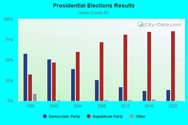
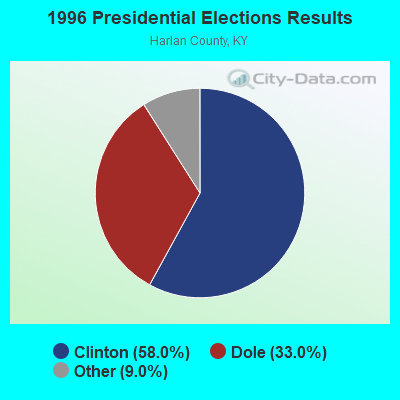
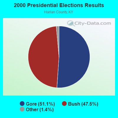

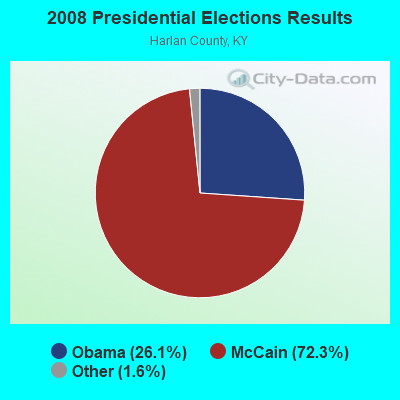
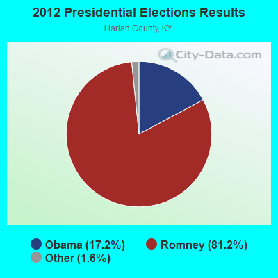

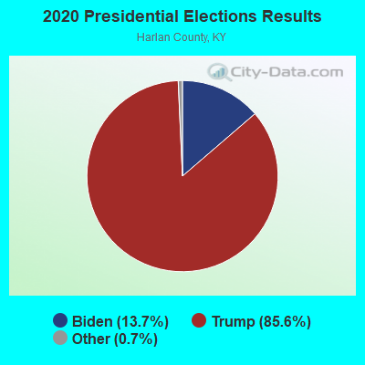
Graphs represent county-level data. Detailed 2008 Election Results
Religion statistics for Pine Mountain, KY (based on Harlan County data)
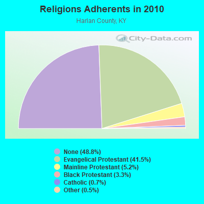
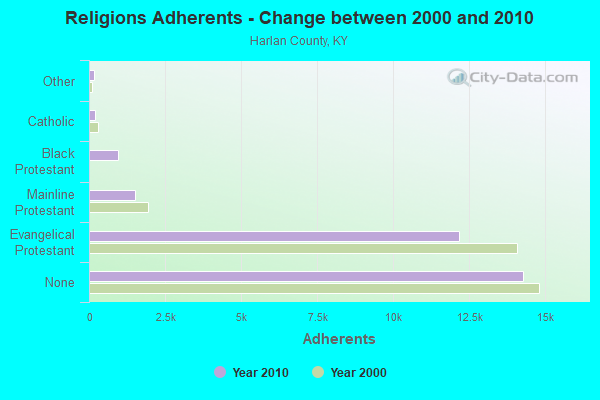
| Religion | Adherents | Congregations |
|---|---|---|
| Evangelical Protestant | 12,152 | 95 |
| Mainline Protestant | 1,524 | 13 |
| Black Protestant | 968 | 3 |
| Catholic | 207 | 3 |
| Other | 151 | 2 |
| None | 14,276 | - |
Food Environment Statistics:
| Harlan County: | 3.22 / 10,000 pop. |
| Kentucky: | 2.19 / 10,000 pop. |
| Harlan County: | 0.64 / 10,000 pop. |
| Kentucky: | 0.74 / 10,000 pop. |
| Here: | 4.18 / 10,000 pop. |
| Kentucky: | 4.36 / 10,000 pop. |
| This county: | 2.57 / 10,000 pop. |
| Kentucky: | 5.74 / 10,000 pop. |
| This county: | 12.9% |
| Kentucky: | 11.0% |
| This county: | 29.8% |
| Kentucky: | 30.0% |
| Harlan County: | 21.0% |
| Kentucky: | 15.9% |
Strongest AM radio stations in Pine Mountain:
- WFSR (970 AM; 5 kW; HARLAN, KY; Owner: EASTERN BROADCASTING COMPAY)
- WHLN (1410 AM; 5 kW; HARLAN, KY)
- WKVL (850 AM; daytime; 50 kW; KNOXVILLE, TN; Owner: HORNE RADIO, LLC)
- WKIC (1390 AM; 5 kW; HAZARD, KY)
- WMIK (560 AM; 2 kW; MIDDLESBORO, KY; Owner: GATEWAY BROADCASTING, INC.)
- WGOC (640 AM; 10 kW; BLOUNTVILLE, TN; Owner: CITADEL BROADCASTING COMPANY)
- WKLB (1290 AM; 5 kW; MANCHESTER, KY; Owner: BARKER BROADCASTING COMPANY, INC.)
- WFGW (1010 AM; 50 kW; BLACK MOUNTAIN, NC; Owner: BLUE RIDGE BROADCASTING CORP.)
- WTCW (920 AM; 4 kW; WHITESBURG, KY; Owner: T.C.W. BROADCASTING , INC.)
- WSWV (1570 AM; 2 kW; PENNINGTON GAP, VA; Owner: IBS COMMUNICATIONS, L.L.C.)
- WPWT (870 AM; daytime; 10 kW; COLONIAL HEIGHTS, TN; Owner: INFORMATION COMMUNICATIONS CORP.)
- WLFJ (660 AM; daytime; 50 kW; GREENVILLE, SC; Owner: CLEAR CHANNEL BROADCASTING LICENSES, INC.)
- WZAP (690 AM; 10 kW; BRISTOL, VA; Owner: RAM COMMUNICATIONS, INC.)
Strongest FM radio stations in Pine Mountain:
- WTUK (105.1 FM; HARLAN, KY; Owner: EASTERN BROADCASTING COMPANY)
- WSEH (102.7 FM; CUMBERLAND, KY; Owner: CUMBERLAND CITY BROADCASTING, INC.)
- WSGS (101.1 FM; HAZARD, KY; Owner: MOUNTAIN BROADCASTING SERVICE, INC.)
- WAXM (93.5 FM; BIG STONE GAP, VA; Owner: VALLEY BROADCASTING, INC.)
- WEKH (90.9 FM; HAZARD, KY; Owner: EASTERN KENTUCKY UNIVERSITY)
- WZQQ (97.9 FM; HYDEN, KY; Owner: LESLIE COUNTY BROADCASTING, INC.)
- WJMD (104.7 FM; HAZARD, KY; Owner: HAZARD BROADCASTING SERVICES)
- W217AB (91.3 FM; HARLAN, KY; Owner: APPALSHOP, INC.)
- W223AA (92.5 FM; BIG STONE GAP, VA; Owner: VALLEY BROADCASTING, INC.)
- WIFX-FM (94.3 FM; JENKINS, KY; Owner: LETCHER COUNTY BROADCASTING, INC)
- WXKQ-FM (103.9 FM; WHITESBURG, KY; Owner: T.C.W. BROADCASTING , INC.)
- WMIK-FM (92.7 FM; MIDDLESBORO, KY; Owner: GATEWAY BROADCASTING, INC.)
- WMMT (88.7 FM; WHITESBURG, KY; Owner: APPALSHOP, INCORPORATED)
- WTFM (98.5 FM; KINGSPORT, TN; Owner: HOLSTON VALLEY BROADCASTING CORP.)
- WRIL (106.3 FM; PINEVILLE, KY; Owner: PINE HILLS BROADCASTING, INC.)
- WJDT (106.5 FM; ROGERSVILLE, TN; Owner: C & S BROADCASTING)
- WBGQ (100.7 FM; BULLS GAP, TN; Owner: CHEROKEE BROADCASTING)
- WCTU (105.9 FM; TAZEWELL, TN; Owner: STAIR COMPANY, INC)
- WDXC (102.3 FM; POUND, VA; Owner: WDXC RADIO, INC.)
- WJNV (99.1 FM; JONESVILLE, VA; Owner: REGINA KAY MOORE)
TV broadcast stations around Pine Mountain:
- WAGV (Channel 44; HARLAN, KY; Owner: LIVING FAITH MINISTRIES, INC.)
- WYMT-TV (Channel 57; HAZARD, KY; Owner: WYMT LICENSEE CORP.)
- W24BT (Channel 24; TALBERT, KY; Owner: MS COMMUNICATIONS, LLC)
- WKHA (Channel 35; HAZARD, KY; Owner: KENTUCKY AUTHORITY FOR EDUCATIONAL TV)
- W31BU (Channel 31; TALBERT, KY; Owner: MS COMMUNICATIONS, LLC)
- W53BQ (Channel 53; TALBERT, KY; Owner: MS COMMUNICATIONS, LLC)
- W69ED (Channel 69; TALBERT, KY; Owner: MS COMMUNICATIONS, LLC)
- W26BK (Channel 26; TALBERT, KY; Owner: MS COMMUNICATIONS, LLC)
- W16BI (Channel 16; TALBERT, KY; Owner: MS COMMUNICATIONS, LLC)
FCC Registered Microwave Towers:
1- Various Locations (Lat: 36.754806 Lon: -83.702694), Overall height: 6.1 m, Call Sign: WPNL682,
Assigned Frequencies: 956.343 MHz, Grant Date: 01/07/2023, Expiration Date: 03/20/2033, Registrant: Keller And Heckman LLP, 1001 G Street Nw, Suite 500 West, Washington, DC 20001, Phone: (202) 434-4100, Fax: (202) 434-4646, Email:

- 60.4%Electricity
- 19.5%Fuel oil, kerosene, etc.
- 8.9%Wood
- 7.4%Coal or coke
- 3.8%Bottled, tank, or LP gas

- 35.9%Electricity
- 30.1%Fuel oil, kerosene, etc.
- 28.8%Coal or coke
- 5.1%Wood
Pine Mountain compared to Kentucky state average:
- Median household income below state average.
- Median house value significantly below state average.
- Black race population percentage significantly below state average.
- Hispanic race population percentage significantly below state average.
- Median age below state average.
- Foreign-born population percentage significantly below state average.
- Renting percentage below state average.
- Length of stay since moving in significantly above state average.
- Number of rooms per house significantly below state average.
- House age significantly below state average.
- Number of college students below state average.
- Percentage of population with a bachelor's degree or higher significantly below state average.