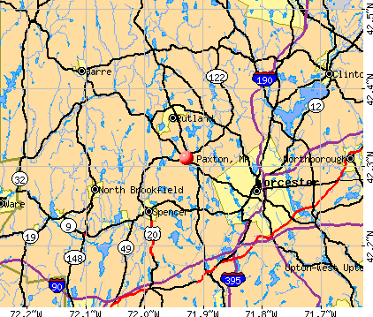
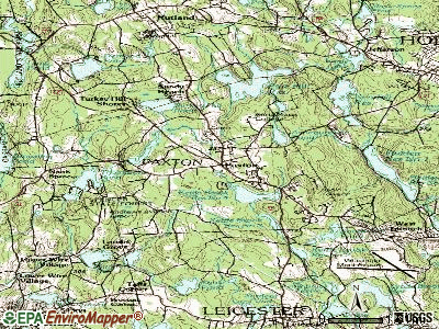
Paxton, Massachusetts
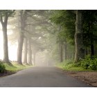
Paxton: Morning Fog
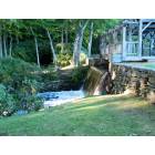
Paxton: Falls at Moore State Park
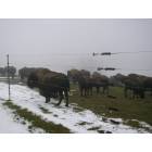
Paxton: buffalos
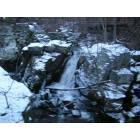
Paxton: water fall
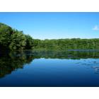
Paxton: Moore State Park
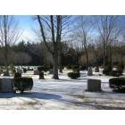
Paxton: cimetary
- add
your
Submit your own pictures of this town and show them to the world
- OSM Map
- General Map
- Google Map
- MSN Map
Population change since 2000: +9.6%
 |
| Males: 2,404 | |
| Females: 2,402 |
| Median resident age: | 39.2 years |
| Massachusetts median age: | 39.2 years |
Zip codes: 01612.
| Paxton: | $129,798 |
| MA: | $94,488 |
Estimated per capita income in 2022: $57,661 (it was $29,573 in 2000)
Paxton town income, earnings, and wages data
Estimated median house or condo value in 2022: $473,886 (it was $171,600 in 2000)
| Paxton: | $473,886 |
| MA: | $534,700 |
Mean prices in 2022: all housing units: $419,164; detached houses: $447,621; townhouses or other attached units: $343,592; in 2-unit structures: $323,295; in 3-to-4-unit structures: $332,295; in 5-or-more-unit structures: $232,758; mobile homes: $113,885
Detailed information about poverty and poor residents in Paxton, MA


- 4,44592.5%White alone
- 1513.1%Hispanic
- 921.9%Black alone
- 621.3%Asian alone
- 491.0%Two or more races
- 30.06%American Indian alone
- 30.06%Other race alone
- 10.02%Native Hawaiian and Other
Pacific Islander alone
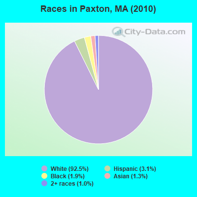
Races in Paxton detailed stats: ancestries, foreign born residents, place of birth
Type |
2009 |
2010 |
2011 |
2012 |
2013 |
2014 |
2015 |
2016 |
2017 |
2018 |
2019 |
2020 |
2021 |
2022 |
|---|---|---|---|---|---|---|---|---|---|---|---|---|---|---|
| Murders (per 100,000) | 0 (0.0) | 0 (0.0) | 0 (0.0) | 0 (0.0) | 0 (0.0) | 0 (0.0) | 0 (0.0) | 0 (0.0) | 0 (0.0) | 0 (0.0) | 0 (0.0) | 0 (0.0) | 0 (0.0) | 0 (0.0) |
| Rapes (per 100,000) | 0 (0.0) | 0 (0.0) | 1 (20.7) | 1 (20.6) | 2 (41.0) | 2 (41.0) | 0 (0.0) | 2 (41.0) | 0 (0.0) | 0 (0.0) | 2 (40.5) | 0 (0.0) | 1 (19.7) | 2 (39.4) |
| Robberies (per 100,000) | 0 (0.0) | 1 (20.8) | 0 (0.0) | 0 (0.0) | 0 (0.0) | 0 (0.0) | 0 (0.0) | 0 (0.0) | 0 (0.0) | 1 (20.5) | 0 (0.0) | 0 (0.0) | 0 (0.0) | 0 (0.0) |
| Assaults (per 100,000) | 1 (21.8) | 4 (83.2) | 5 (103.4) | 2 (41.1) | 2 (41.0) | 5 (102.6) | 4 (82.3) | 5 (102.6) | 2 (40.9) | 2 (40.9) | 6 (121.4) | 1 (20.2) | 7 (138.1) | 8 (157.7) |
| Burglaries (per 100,000) | 6 (131.0) | 12 (249.7) | 12 (248.2) | 16 (328.9) | 10 (204.8) | 10 (205.1) | 9 (185.1) | 5 (102.6) | 5 (102.2) | 1 (20.5) | 1 (20.2) | 2 (40.4) | 3 (59.2) | 1 (19.7) |
| Thefts (per 100,000) | 15 (327.5) | 10 (208.1) | 13 (268.9) | 19 (390.6) | 14 (286.7) | 9 (184.6) | 12 (246.8) | 10 (205.2) | 12 (245.3) | 12 (245.5) | 9 (182.0) | 8 (161.5) | 10 (197.3) | 11 (216.8) |
| Auto thefts (per 100,000) | 1 (21.8) | 0 (0.0) | 1 (20.7) | 1 (20.6) | 1 (20.5) | 0 (0.0) | 0 (0.0) | 1 (20.5) | 0 (0.0) | 1 (20.5) | 2 (40.5) | 0 (0.0) | 3 (59.2) | 1 (19.7) |
| Arson (per 100,000) | 0 (0.0) | 1 (20.8) | 1 (20.7) | 0 (0.0) | 0 (0.0) | 0 (0.0) | 0 (0.0) | 0 (0.0) | 0 (0.0) | 0 (0.0) | 0 (0.0) | 0 (0.0) | 0 (0.0) | 0 (0.0) |
| City-Data.com crime index | 28.4 | 48.7 | 67.0 | 65.0 | 68.4 | 75.1 | 39.3 | 70.4 | 25.1 | 27.2 | 68.6 | 13.3 | 60.2 | 74.7 |
The City-Data.com crime index weighs serious crimes and violent crimes more heavily. Higher means more crime, U.S. average is 246.1. It adjusts for the number of visitors and daily workers commuting into cities.
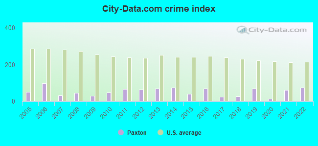
Crime rate in Paxton detailed stats: murders, rapes, robberies, assaults, burglaries, thefts, arson
Full-time law enforcement employees in 2021, including police officers: 16 (14 officers - 14 male; 0 female).
| Officers per 1,000 residents here: | 2.76 |
| Massachusetts average: | 2.53 |
 Recent articles from our blog. Our writers, many of them Ph.D. graduates or candidates, create easy-to-read articles on a wide variety of topics.

 | Rachael Rollins confirmed as Massachusetts US Attorney (191 replies) |
| Coronavirus in Massachusetts (18048 replies) |
| Red Sox 2021 (138 replies) |
| Could my young family be happy in MA? (152 replies) |
| Moving Small Family to Worcester. Advice? (25 replies) |
| Moving to MA from out of state - figuring out how to pick the "right" suburb for me and my family (81 replies) |
Latest news from Paxton, MA collected exclusively by city-data.com from local newspapers, TV, and radio stations
Ancestries: Irish (25.6%), English (16.4%), Italian (15.3%), French (12.4%), Polish (8.5%), German (7.4%).
Current Local Time: EST time zone
Incorporated in 1775
Elevation: 1158 feet
Land area: 14.7 square miles.
Population density: 326 people per square mile (very low).
340 residents are foreign born (5.1% Europe, 1.2% Asia, 0.8% Latin America).
| This town: | 7.8% |
| Massachusetts: | 12.2% |
| Paxton town: | 1.5% ($2,584) |
| Massachusetts: | 1.3% ($2,336) |
Nearest city with pop. 50,000+: Worcester, MA  (6.5 miles , pop. 172,648).
Nearest city with pop. 200,000+: Boston, MA (42.5 miles , pop. 589,141).
Nearest city with pop. 1,000,000+: Bronx, NY (142.9 miles , pop. 1,332,650).
Nearest cities:
Latitude: 42.31 N, Longitude: 71.92 W

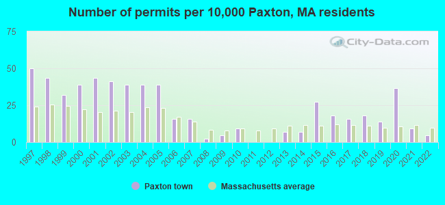
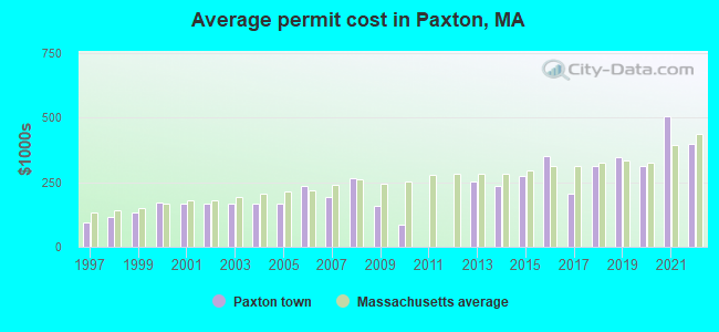
Single-family new house construction building permits:
- 2022: 2 buildings, average cost: $398,500
- 2021: 4 buildings, average cost: $506,300
- 2020: 16 buildings, average cost: $312,500
- 2019: 6 buildings, average cost: $348,700
- 2018: 8 buildings, average cost: $314,800
- 2017: 7 buildings, average cost: $204,300
- 2016: 8 buildings, average cost: $350,000
- 2015: 12 buildings, average cost: $272,500
- 2014: 3 buildings, average cost: $237,300
- 2013: 3 buildings, average cost: $253,300
- 2010: 4 buildings, average cost: $84,300
- 2009: 2 buildings, average cost: $158,000
- 2008: 1 building, cost: $267,000
- 2007: 7 buildings, average cost: $193,000
- 2006: 7 buildings, average cost: $235,700
- 2005: 17 buildings, average cost: $167,300
- 2004: 17 buildings, average cost: $167,300
- 2003: 17 buildings, average cost: $167,200
- 2002: 18 buildings, average cost: $167,600
- 2001: 19 buildings, average cost: $166,100
- 2000: 17 buildings, average cost: $172,600
- 1999: 14 buildings, average cost: $131,700
- 1998: 19 buildings, average cost: $115,700
- 1997: 22 buildings, average cost: $95,700
| Here: | 2.8% |
| Massachusetts: | 3.5% |
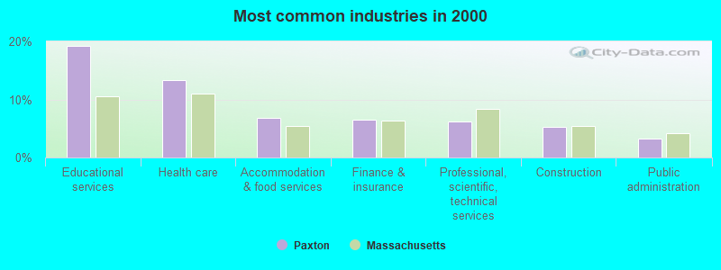
- Educational services (19.3%)
- Health care (13.3%)
- Accommodation & food services (6.8%)
- Finance & insurance (6.6%)
- Professional, scientific, technical services (6.2%)
- Construction (5.3%)
- Public administration (3.2%)
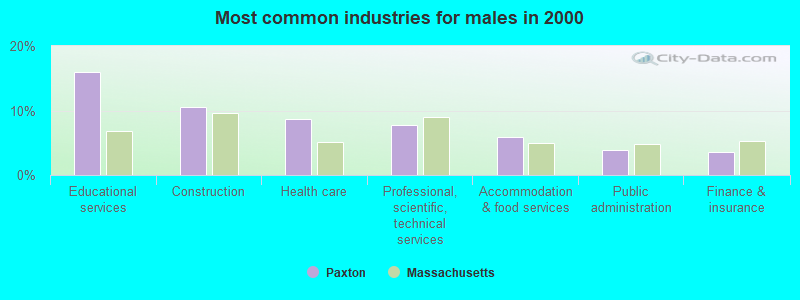
- Educational services (15.9%)
- Construction (10.6%)
- Health care (8.6%)
- Professional, scientific, technical services (7.8%)
- Accommodation & food services (5.9%)
- Public administration (4.0%)
- Finance & insurance (3.6%)
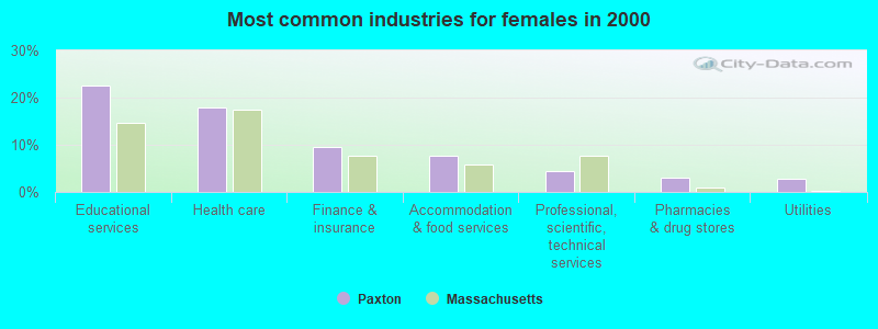
- Educational services (22.6%)
- Health care (17.9%)
- Finance & insurance (9.5%)
- Accommodation & food services (7.7%)
- Professional, scientific, technical services (4.5%)
- Pharmacies & drug stores (3.0%)
- Utilities (2.9%)
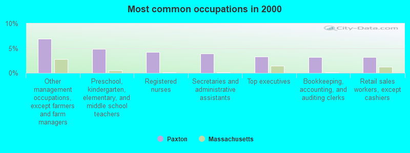
- Other management occupations, except farmers and farm managers (6.9%)
- Preschool, kindergarten, elementary, and middle school teachers (4.9%)
- Registered nurses (4.2%)
- Secretaries and administrative assistants (3.9%)
- Top executives (3.3%)
- Bookkeeping, accounting, and auditing clerks (3.2%)
- Retail sales workers, except cashiers (3.2%)
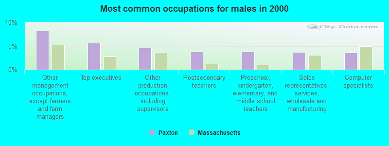
- Other management occupations, except farmers and farm managers (8.3%)
- Top executives (5.7%)
- Other production occupations, including supervisors (4.7%)
- Postsecondary teachers (3.9%)
- Preschool, kindergarten, elementary, and middle school teachers (3.8%)
- Sales representatives, services, wholesale and manufacturing (3.7%)
- Computer specialists (3.6%)
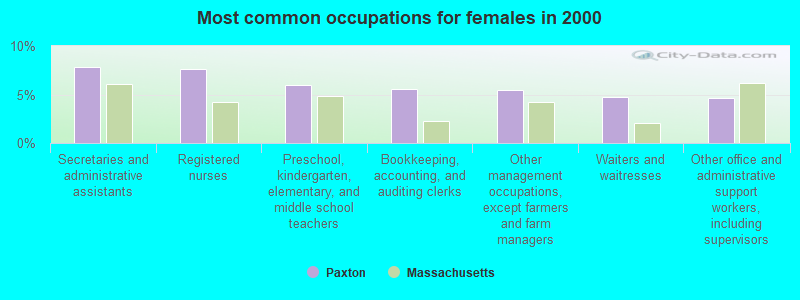
- Secretaries and administrative assistants (7.8%)
- Registered nurses (7.7%)
- Preschool, kindergarten, elementary, and middle school teachers (5.9%)
- Bookkeeping, accounting, and auditing clerks (5.6%)
- Other management occupations, except farmers and farm managers (5.5%)
- Waiters and waitresses (4.8%)
- Other office and administrative support workers, including supervisors (4.7%)
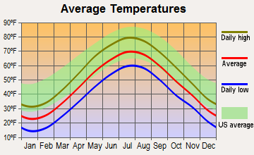
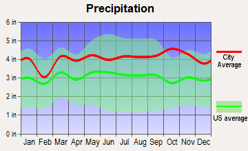
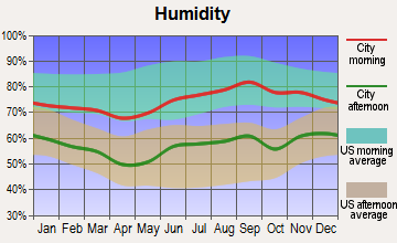
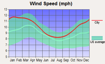
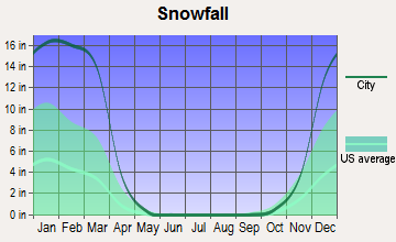
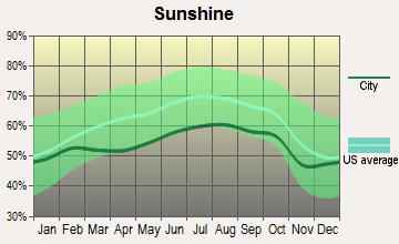
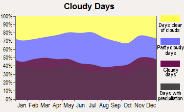
Average climate in Paxton, Massachusetts
Based on data reported by over 4,000 weather stations
(lower is better)
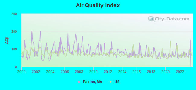
Air Quality Index (AQI) level in 2022 was 66.7. This is about average.
| City: | 66.7 |
| U.S.: | 72.6 |
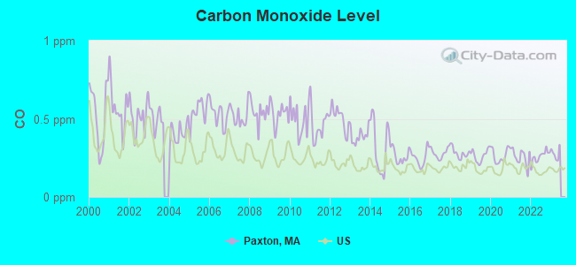
Carbon Monoxide (CO) [ppm] level in 2022 was 0.259. This is about average. Closest monitor was 6.8 miles away from the city center.
| City: | 0.259 |
| U.S.: | 0.251 |
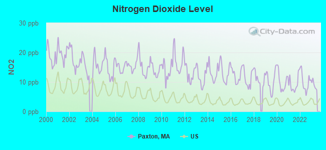
Nitrogen Dioxide (NO2) [ppb] level in 2022 was 10.1. This is significantly worse than average. Closest monitor was 6.3 miles away from the city center.
| City: | 10.1 |
| U.S.: | 5.1 |
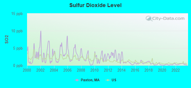
Sulfur Dioxide (SO2) [ppb] level in 2022 was 0.355. This is significantly better than average. Closest monitor was 6.3 miles away from the city center.
| City: | 0.355 |
| U.S.: | 1.515 |
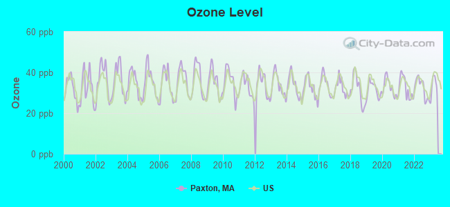
Ozone [ppb] level in 2022 was 32.3. This is about average. Closest monitor was 2.4 miles away from the city center.
| City: | 32.3 |
| U.S.: | 33.3 |
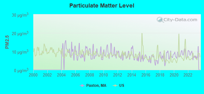
Particulate Matter (PM2.5) [µg/m3] level in 2022 was 8.48. This is about average. Closest monitor was 7.0 miles away from the city center.
| City: | 8.48 |
| U.S.: | 8.11 |
Tornado activity:
Paxton-area historical tornado activity is slightly above Massachusetts state average. It is 17% smaller than the overall U.S. average.
On 6/9/1953, a category F4 (max. wind speeds 207-260 mph) tornado 17.0 miles away from the Paxton town center killed 90 people and injured 1228 people and caused between $50,000,000 and $500,000,000 in damages.
On 6/9/1953, a category F3 (max. wind speeds 158-206 mph) tornado 12.2 miles away from the town center injured 17 people and caused between $500,000 and $5,000,000 in damages.
Earthquake activity:
Paxton-area historical earthquake activity is significantly above Massachusetts state average. It is 71% smaller than the overall U.S. average.On 10/7/1983 at 10:18:46, a magnitude 5.3 (5.1 MB, 5.3 LG, 5.1 ML, Class: Moderate, Intensity: VI - VII) earthquake occurred 167.0 miles away from the city center
On 4/20/2002 at 10:50:47, a magnitude 5.3 (5.3 ML, Depth: 3.0 mi) earthquake occurred 176.7 miles away from Paxton center
On 4/20/2002 at 10:50:47, a magnitude 5.2 (5.2 MB, 4.2 MS, 5.2 MW, 5.0 MW) earthquake occurred 175.8 miles away from Paxton center
On 1/19/1982 at 00:14:42, a magnitude 4.7 (4.5 MB, 4.7 MD, 4.5 LG, Class: Light, Intensity: IV - V) earthquake occurred 84.0 miles away from the city center
On 10/16/2012 at 23:12:25, a magnitude 4.7 (4.7 ML, Depth: 10.0 mi) earthquake occurred 109.8 miles away from the city center
On 8/22/1992 at 12:20:32, a magnitude 4.8 (4.8 MB, 3.8 MS, 4.7 LG, Depth: 6.2 mi) earthquake occurred 236.8 miles away from the city center
Magnitude types: regional Lg-wave magnitude (LG), body-wave magnitude (MB), duration magnitude (MD), local magnitude (ML), surface-wave magnitude (MS), moment magnitude (MW)
Natural disasters:
The number of natural disasters in Worcester County (27) is a lot greater than the US average (15).Major Disasters (Presidential) Declared: 15
Emergencies Declared: 12
Causes of natural disasters: Floods: 9, Storms: 8, Hurricanes: 6, Snowstorms: 5, Winter Storms: 4, Blizzards: 2, Snows: 2, Fire: 1, Heavy Rain: 1, Snowfall: 1, Tornado: 1, Wind: 1 (Note: some incidents may be assigned to more than one category).
Hospitals and medical centers near Paxton:
- OUR LADY OF MERCY HEALTH CARE (Nursing Home, about 5 miles away; WORCESTER, MA)
- MEDICAL CTR OF CENTRAL MASS-HOLDEN (Hospital, about 5 miles away; HOLDEN, MA)
- JEWISH HOME HOSPICE (Hospital, about 5 miles away; WORCESTER, MA)
- WACHUSETT EXTENDED CARE FACILITY (Nursing Home, about 5 miles away; HOLDEN, MA)
- JEWISH HEALTHCARE CENTER (Nursing Home, about 5 miles away; WORCESTER, MA)
- HOLDEN NURSING HOME (Nursing Home, about 5 miles away; HOLDEN, MA)
- HOLDEN REHABILITATION AND SKILLED NURSING CENTER INC (Nursing Home, about 5 miles away; HOLDEN, MA)
Amtrak station near Paxton:
College/University in Paxton:
Colleges/universities with over 2000 students nearest to Paxton:
- Assumption College (about 5 miles; Worcester, MA; Full-time enrollment: 2,580)
- Worcester State University (about 5 miles; Worcester, MA; FT enrollment: 5,426)
- Worcester Polytechnic Institute (about 7 miles; Worcester, MA; FT enrollment: 3,930)
- Clark University (about 7 miles; Worcester, MA; FT enrollment: 3,687)
- Quinsigamond Community College (about 7 miles; Worcester, MA; FT enrollment: 5,877)
- College of the Holy Cross (about 8 miles; Worcester, MA; FT enrollment: 3,125)
- Mount Wachusett Community College (about 21 miles; Gardner, MA; FT enrollment: 3,143)
Public elementary/middle school in Paxton:
- PAXTON CENTER (Students: 501, Location: 19 WEST STREET, Grades: KG-8)
Points of interest:
Notable locations in Paxton: Paxton Fire Department (A), Richards Memorial Library (B). Display/hide their locations on the map
Church in Paxton: First Congregational Church (A). Display/hide its location on the map
Cemetery: Mooreland Cemetery (1). Display/hide its location on the map
Lakes and reservoirs: Streeter Pond (A), Harrington Pond (B), Pine Hill Reservoir (C), Kettle Brook Reservoir Number Three (D), Kettle Brook Reservoir Number Four (E), Eames Pond (F), Asnebumskit Pond (G). Display/hide their locations on the map
Streams, rivers, and creeks: Bumbo Brook (A). Display/hide its location on the map
Birthplace of: David Goodman (Medal of Honor) - Army Medal of Honor recipient.
Drinking water stations with addresses in Paxton and their reported violations in the past:
PAXTON WATER DEPARTMENT (Population served: 3,608, Purch surface water):Past health violations:Past monitoring violations:
- MCL, Acute (TCR) - In AUG-2009, Contaminant: Coliform. Follow-up actions: St AO (w/o penalty) issued (SEP-22-2009), St Compliance achieved (SEP-22-2009)
- MCL, Monthly (TCR) - In AUG-2009, Contaminant: Coliform. Follow-up actions: St AO (w/o penalty) issued (SEP-22-2009), St Compliance achieved (SEP-22-2009)
- Monitoring and Reporting (DBP) - Between JUL-2013 and SEP-2013, Contaminant: Total Haloacetic Acids (HAA5). Follow-up actions: St AO (w/o penalty) issued (MAR-03-2014), St Compliance achieved (MAR-03-2014)
- One minor monitoring violation
| This town: | 2.8 people |
| Massachusetts: | 2.5 people |
| This town: | 80.1% |
| Whole state: | 63.0% |
| This town: | 4.2% |
| Whole state: | 7.0% |
Likely homosexual households (counted as self-reported same-sex unmarried-partner households)
- Lesbian couples: 0.6% of all households
- Gay men: 0.3% of all households
| This town: | 1.8% |
| Whole state: | 9.3% |
| This town: | 0.9% |
| Whole state: | 4.4% |
4 people in group homes intended for adults in 2010
People in group quarters in Paxton in 2000:
- 381 people in college dormitories (includes college quarters off campus)
- 16 people in homes for the mentally retarded
- 5 people in nursing homes
Banks with branches in Paxton (2011 data):
- Barre Savings Bank: Paxton Branch at 713 Pleasant Street, branch established on 1991/06/24. Info updated 2008/03/03: Bank assets: $144.3 mil, Deposits: $108.5 mil, headquarters in Barre, MA, positive income, Mortgage Lending Specialization, 3 total offices
- Country Bank for Savings: Paxton Branch at 687 Pleasant Street, branch established on 2004/06/10. Info updated 2006/09/29: Bank assets: $1,431.1 mil, Deposits: $953.8 mil, headquarters in Ware, MA, positive income, Mortgage Lending Specialization, 15 total offices
For population 15 years and over in Paxton:
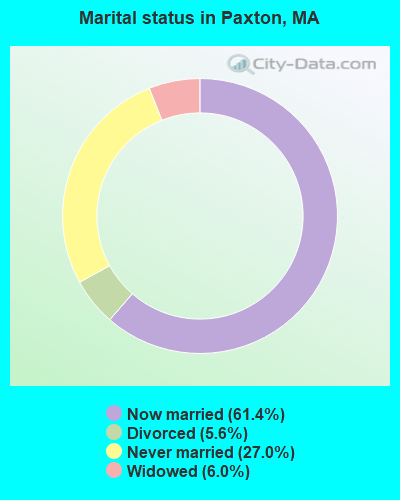
- Never married: 27.0%
- Now married: 61.4%
- Separated: 0.0%
- Widowed: 6.0%
- Divorced: 5.6%
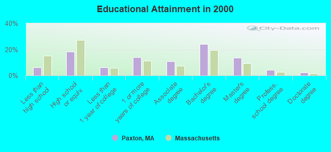
For population 25 years and over in Paxton:
- High school or higher: 93.9%
- Bachelor's degree or higher: 44.2%
- Graduate or professional degree: 20.0%
- Unemployed: 2.9%
- Mean travel time to work (commute): 24.0 minutes
| Here: | 10.5 |
| Massachusetts average: | 13.1 |


Graphs represent county-level data. Detailed 2008 Election Results
Religion statistics for Paxton, MA (based on Worcester County data)


| Religion | Adherents | Congregations |
|---|---|---|
| Catholic | 306,925 | 118 |
| Mainline Protestant | 43,326 | 171 |
| Evangelical Protestant | 37,511 | 203 |
| Other | 18,931 | 69 |
| Orthodox | 7,935 | 15 |
| Black Protestant | 497 | 6 |
| None | 383,427 | - |
Food Environment Statistics:
| Worcester County: | 1.73 / 10,000 pop. |
| Massachusetts: | 1.98 / 10,000 pop. |
| Here: | 0.05 / 10,000 pop. |
| Massachusetts: | 0.05 / 10,000 pop. |
| Worcester County: | 1.79 / 10,000 pop. |
| Massachusetts: | 2.22 / 10,000 pop. |
| Worcester County: | 2.22 / 10,000 pop. |
| Massachusetts: | 1.77 / 10,000 pop. |
| This county: | 7.27 / 10,000 pop. |
| Massachusetts: | 8.76 / 10,000 pop. |
| Worcester County: | 8.0% |
| State: | 8.1% |
| Worcester County: | 24.0% |
| Massachusetts: | 22.5% |
| This county: | 16.6% |
| State: | 16.5% |
4.71% of this county's 2021 resident taxpayers lived in other counties in 2020 ($76,229 average adjusted gross income)
| Here: | 4.71% |
| Massachusetts average: | 6.35% |
0.02% of residents moved from foreign countries ($100 average AGI)
Worcester County: 0.02% Massachusetts average: 0.01%
Top counties from which taxpayers relocated into this county between 2020 and 2021:
| from Middlesex County, MA | |
| from Norfolk County, MA | |
| from Suffolk County, MA |
4.84% of this county's 2020 resident taxpayers moved to other counties in 2021 ($87,252 average adjusted gross income)
| Here: | 4.84% |
| Massachusetts average: | 7.18% |
0.03% of residents moved to foreign countries ($199 average AGI)
Worcester County: 0.03% Massachusetts average: 0.02%
Top counties to which taxpayers relocated from this county between 2020 and 2021:
| to Middlesex County, MA | |
| to Norfolk County, MA | |
| to Suffolk County, MA |
Businesses in Paxton, MA
- Dunkin Donuts: 1
Strongest AM radio stations in Paxton:
- WCRN (830 AM; 50 kW; WORCESTER, MA; Owner: CARTER BROADCASTING CORPORATION)
- WVNE (760 AM; daytime; 25 kW; LEICESTER, MA; Owner: BLOUNT MASSCOM, INC.)
- WTAG (580 AM; 5 kW; WORCESTER, MA; Owner: CAPSTAR TX LIMITED PARTNERSHIP)
- WVEI (1440 AM; 5 kW; WORCESTER, MA; Owner: ENTERCOM BOSTON LICENSE, LLC)
- WKOX (1200 AM; 50 kW; FRAMINGHAM, MA; Owner: CAPSTAR TX LIMITED PARTNERSHIP)
- WORC (1310 AM; 5 kW; WORCESTER, MA; Owner: CHOWDER BROADCAST GROUP LLC)
- WBIX (1060 AM; 40 kW; NATICK, MA; Owner: LANGER BROADCASTING CORPORATION)
- WALE (990 AM; 50 kW; GREENVILLE, RI; Owner: NORTH AMERICAN BROADCASTING CO., INC.)
- WEEI (850 AM; 50 kW; BOSTON, MA; Owner: ENTERCOM BOSTON LICENSE, LLC)
- WRKO (680 AM; 50 kW; BOSTON, MA; Owner: ENTERCOM BOSTON LICENSE, LLC)
- WAMG (890 AM; 25 kW; DEDHAM, MA; Owner: MEGA COMMUNICATIONS OF DEDHAM LICENSEE, LLC)
- WNNZ (640 AM; 50 kW; WESTFIELD, MA; Owner: CLEAR CHANNEL BROADCASTING LICENSES, INC.)
- WNEB (1230 AM; 1 kW; WORCESTER, MA; Owner: GRACE BROADCASTING CORPORATION)
Strongest FM radio stations in Paxton:
- WSRS (96.1 FM; WORCESTER, MA; Owner: CAPSTAR TX LIMITED PARTNERSHIP)
- WAAF (107.3 FM; WORCESTER, MA; Owner: ENTERCOM BOSTON LICENSE, LLC)
- WBPR (91.9 FM; WORCESTER, MA; Owner: UNIVERSITY OF MASSACHUSETTS)
- WICN (90.5 FM; WORCESTER, MA; Owner: WICN PUBLIC RADIO, INC)
- WXLO (104.5 FM; FITCHBURG, MA; Owner: CITADEL BROADCASTING COMPANY)
- WYCM (90.1 FM; CHARLTON, MA; Owner: BAY PATH VOCATIONAL HIGH SCHOOL)
- WFCR (88.5 FM; AMHERST, MA; Owner: UNIVERSITY OF MASSACHUSETTS)
- WCUW (91.3 FM; WORCESTER, MA; Owner: WUW, INC.)
- WFEX (92.1 FM; PETERBOROUGH, NH; Owner: FNX BROADCASTING OF NEW HAMPSHIRE LLC)
- WBMX (98.5 FM; BOSTON, MA; Owner: INFINITY RADIO OPERATIONS INC.)
- WJMN (94.5 FM; BOSTON, MA; Owner: AMFM RADIO LICENSES, L.L.C.)
- WCRB (102.5 FM; WALTHAM, MA; Owner: CHARLES RIVER BROADCASTING WCRB LICE)
- WTKK (96.9 FM; BOSTON, MA; Owner: GREATER BOSTON RADIO, INC.)
- WROR-FM (105.7 FM; FRAMINGHAM, MA; Owner: GREATER BOSTON RADIO, INC.)
- WBOS (92.9 FM; BROOKLINE, MA; Owner: GREATER BOSTON RADIO, INC.)
- WWFX (100.1 FM; SOUTHBRIDGE, MA; Owner: CITADEL BROADCASTING COMPANY)
- WAMH (89.3 FM; AMHERST, MA; Owner: TRUSTEES OF AMHERST COLLEGE)
- WGBH (89.7 FM; BOSTON, MA; Owner: WGBH EDUCATIONAL FOUNDATION)
- WBUR-FM (90.9 FM; BOSTON, MA; Owner: TRUSTEES OF BOSTON UNIVERSITY)
- WORC-FM (98.9 FM; WEBSTER, MA; Owner: CITADEL BROADCASTING COMPANY)
TV broadcast stations around Paxton:
- WUNI (Channel 27; WORCESTER, MA; Owner: ENTRAVISION HOLDINGS, LLC)
- WCRN-LP (Channel 34; LEICESTER, MA; Owner: CARTER BROADCASTING CORPORATION)
- WYDN (Channel 48; WORCESTER, MA; Owner: EDUCATIONAL PUBLIC TV CORPORATION)
- WUTF (Channel 66; MARLBOROUGH, MA; Owner: TELEFUTURA BOSTON LLC)
- WCVB-TV (Channel 5; BOSTON, MA; Owner: WCVB HEARST-ARGYLE TV, INC.)
- WGBH-TV (Channel 2; BOSTON, MA; Owner: WGBH EDUCATIONAL FOUNDATION)
- WHDH-TV (Channel 7; BOSTON, MA; Owner: WHDH-TV)
- WMFP (Channel 62; LAWRENCE, MA; Owner: WSAH LICENSE, INC.)
- WBZ-TV (Channel 4; BOSTON, MA; Owner: VIACOM INC.)
- WGBX-TV (Channel 44; BOSTON, MA; Owner: WGBH EDUCATIONAL FOUNDATION)
- WSBK-TV (Channel 38; BOSTON, MA; Owner: VIACOM INC.)
- WLVI-TV (Channel 56; CAMBRIDGE, MA; Owner: WLVI, INC.)
- WFXT (Channel 25; BOSTON, MA; Owner: FOX TELEVISION STATIONS INC.)
- WPXQ (Channel 69; BLOCK ISLAND, RI; Owner: OCEAN STATE TELEVISION, L.L.C.)
- W40BO (Channel 40; BOSTON, MA; Owner: PAXSON COMMUNICATIONS LPTV, INC.)
- WBPX (Channel 68; BOSTON, MA; Owner: PAXSON BOSTON-68 LICENSE, INC.)
Medal of Honor Recipients
Medal of Honor Recipient born in Paxton: David Goodman.
FCC Registered Commercial Land Mobile Towers: 1 (See the full list of FCC Registered Commercial Land Mobile Towers in Paxton, MA)
FCC Registered Private Land Mobile Towers: 16 (See the full list of FCC Registered Private Land Mobile Towers)
FCC Registered Broadcast Land Mobile Towers: 9 (See the full list of FCC Registered Broadcast Land Mobile Towers)
FCC Registered Microwave Towers: 28 (See the full list of FCC Registered Microwave Towers in this town)
FCC Registered Paging Towers: 23 (See the full list of FCC Registered Paging Towers)
FCC Registered Maritime Coast & Aviation Ground Towers: 1 (See the full list of FCC Registered Maritime Coast & Aviation Ground Towers)
FCC Registered Amateur Radio Licenses: 25 (See the full list of FCC Registered Amateur Radio Licenses in Paxton)
FAA Registered Aircraft: 8 (See the full list of FAA Registered Aircraft in Paxton)
2002 - 2018 National Fire Incident Reporting System (NFIRS) incidents
- Fire incident types reported to NFIRS in Paxton, MA
- 16568.8%Structure Fires
- 3313.8%Mobile Property/Vehicle Fires
- 2912.1%Outside Fires
- 135.4%Other
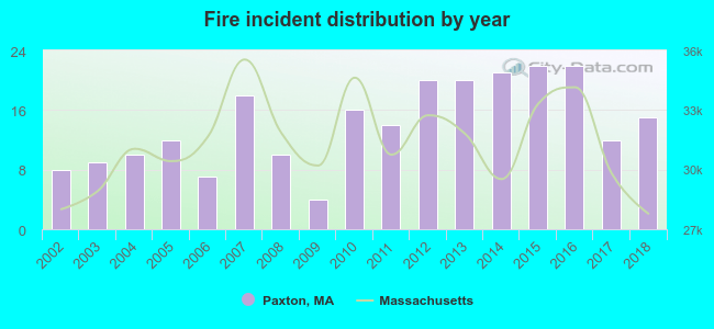 According to the data from the years 2002 - 2018 the average number of fire incidents per year is 14. The highest number of reported fire incidents - 22 took place in 2015, and the least - 4 in 2009. The data has a growing trend.
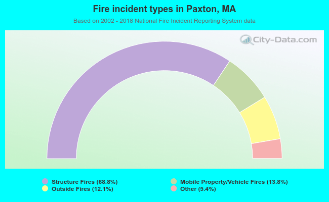 When looking into fire subcategories, the most reports belonged to: Structure Fires (68.8%), and Mobile Property/Vehicle Fires (13.8%).
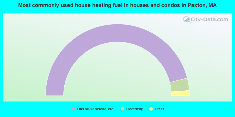
- 92.1%Fuel oil, kerosene, etc.
- 5.6%Electricity
- 1.5%Bottled, tank, or LP gas
- 0.4%Other fuel
- 0.4%Wood
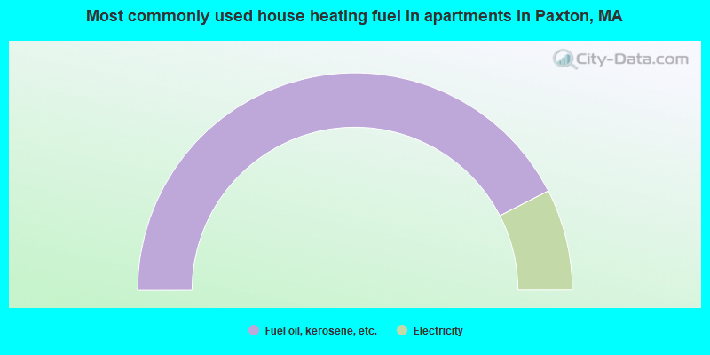
- 84.9%Fuel oil, kerosene, etc.
- 15.1%Electricity
Paxton compared to Massachusetts state average:
- Unemployed percentage significantly below state average.
- Black race population percentage significantly below state average.
- Hispanic race population percentage significantly below state average.
- Foreign-born population percentage significantly below state average.
- Renting percentage significantly below state average.
- Length of stay since moving in significantly above state average.
- Number of rooms per house significantly below state average.
- House age significantly below state average.

|
|
Total of 41 patent applications in 2008-2024.