Orford, New Hampshire


Submit your own pictures of this town and show them to the world
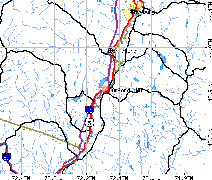
- OSM Map
- General Map
- Google Map
- MSN Map
Population change since 2000: +13.4%
 |
| Males: 602 | |
| Females: 635 |
| Median resident age: | 45.0 years |
| New Hampshire median age: | 43.9 years |
Zip codes: 03777.
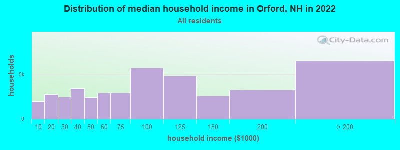
| Orford: | $90,429 |
| NH: | $89,992 |
Estimated per capita income in 2022: $55,021 (it was $24,196 in 2000)
Orford town income, earnings, and wages data
Estimated median house or condo value in 2022: $385,785 (it was $120,700 in 2000)
| Orford: | $385,785 |
| NH: | $384,700 |
Mean prices in 2022: all housing units: $486,096; detached houses: $533,852; townhouses or other attached units: $375,744; in 2-unit structures: $230,260; in 3-to-4-unit structures: $242,363; in 5-or-more-unit structures: $588,257; mobile homes: $127,035
Detailed information about poverty and poor residents in Orford, NH


- 1,19696.7%White alone
- 191.5%Two or more races
- 90.7%Asian alone
- 80.6%Hispanic
- 50.4%Black alone

Races in Orford detailed stats: ancestries, foreign born residents, place of birth
Type |
2009 |
2010 |
2011 |
2012 |
2013 |
2014 |
2015 |
2016 |
2019 |
2020 |
2021 |
2022 |
|---|---|---|---|---|---|---|---|---|---|---|---|---|
| Murders (per 100,000) | 0 (0.0) | 0 (0.0) | 0 (0.0) | 0 (0.0) | 0 (0.0) | 0 (0.0) | 0 (0.0) | 0 (0.0) | 0 (0.0) | 0 (0.0) | 1 (75.6) | 0 (0.0) |
| Rapes (per 100,000) | 0 (0.0) | 0 (0.0) | 0 (0.0) | 0 (0.0) | 0 (0.0) | 1 (80.3) | 0 (0.0) | 1 (80.3) | 0 (0.0) | 0 (0.0) | 0 (0.0) | 0 (0.0) |
| Robberies (per 100,000) | 0 (0.0) | 0 (0.0) | 0 (0.0) | 0 (0.0) | 0 (0.0) | 0 (0.0) | 0 (0.0) | 0 (0.0) | 0 (0.0) | 0 (0.0) | 0 (0.0) | 0 (0.0) |
| Assaults (per 100,000) | 1 (94.9) | 0 (0.0) | 0 (0.0) | 1 (81.0) | 0 (0.0) | 0 (0.0) | 0 (0.0) | 0 (0.0) | 1 (76.8) | 0 (0.0) | 0 (0.0) | 0 (0.0) |
| Burglaries (per 100,000) | 2 (189.8) | 0 (0.0) | 2 (161.4) | 3 (242.9) | 3 (243.3) | 1 (80.3) | 1 (80.1) | 1 (80.3) | 0 (0.0) | 0 (0.0) | 1 (75.6) | 0 (0.0) |
| Thefts (per 100,000) | 2 (189.8) | 8 (646.7) | 5 (403.6) | 11 (890.7) | 2 (162.2) | 1 (80.3) | 2 (160.1) | 0 (0.0) | 3 (230.4) | 13 (993.9) | 13 (982.6) | 8 (638.5) |
| Auto thefts (per 100,000) | 0 (0.0) | 0 (0.0) | 0 (0.0) | 1 (81.0) | 0 (0.0) | 0 (0.0) | 0 (0.0) | 0 (0.0) | 0 (0.0) | 0 (0.0) | 0 (0.0) | 0 (0.0) |
| Arson (per 100,000) | 0 (0.0) | 0 (0.0) | 0 (0.0) | 0 (0.0) | 0 (0.0) | 0 (0.0) | 0 (0.0) | 0 (0.0) | 0 (0.0) | 0 (0.0) | 0 (0.0) | 0 (0.0) |
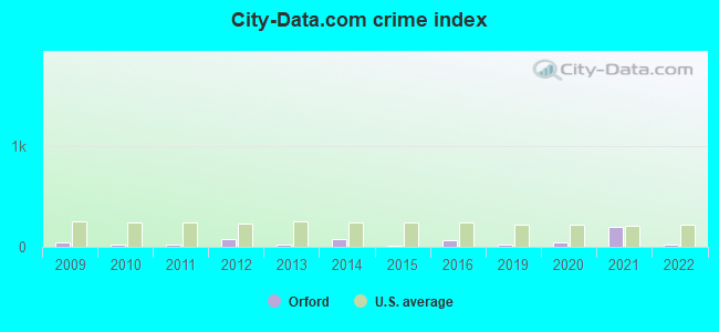
| City-Data.com crime index | 39.8 | 25.9 | 27.4 | 75.3 | 23.5 | 73.0 | 12.0 | 69.8 | 24.6 | 39.8 | 195.8 | 25.5 |
The City-Data.com crime index weighs serious crimes and violent crimes more heavily. Higher means more crime, U.S. average is 246.1. It adjusts for the number of visitors and daily workers commuting into cities.
Crime rate in Orford detailed stats: murders, rapes, robberies, assaults, burglaries, thefts, arson
Full-time law enforcement employees in 2021, including police officers: 1 (1 officers - 1 male; 0 female).
| Officers per 1,000 residents here: | 0.76 |
| New Hampshire average: | 2.14 |
 Recent articles from our blog. Our writers, many of them Ph.D. graduates or candidates, create easy-to-read articles on a wide variety of topics.

 | Relocation suggestions (30 replies) |
| How do NH voters feel about Maura Sullivan, the nationally backed D candidate for the 1st congressional district? (69 replies) |
| Littleton v. Orford (2 replies) |
| Help me get rid of comcast (34 replies) |
| Some ideas for relocation? (18 replies) |
| relocating to lebanon/hanover area (5 replies) |
Latest news from Orford, NH collected exclusively by city-data.com from local newspapers, TV, and radio stations
Ancestries: English (29.3%), German (13.5%), Irish (12.7%), French (9.3%), United States (6.1%), Scottish (4.2%).
Current Local Time: EST time zone
Incorporated in 1761
Elevation: 419 feet
Land area: 46.7 square miles.
Population density: 27 people per square mile (very low).
27 residents are foreign born (0.7% Asia, 0.7% Africa, 0.5% Europe, 0.3% North America).
| This town: | 2.5% |
| New Hampshire: | 4.4% |
| Orford town: | 2.2% ($2,676) |
| New Hampshire: | 2.3% ($2,946) |
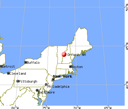
Nearest city with pop. 50,000+: Manchester, NH  (71.2 miles , pop. 107,006).
Nearest city with pop. 200,000+: Boston, MA (120.6 miles , pop. 589,141).
Nearest city with pop. 1,000,000+: Bronx, NY (230.8 miles , pop. 1,332,650).
Nearest cities:
), ), ), ), ), )Latitude: 43.91 N, Longitude: 72.08 W
Area code: 603

| Here: | 1.5% |
| New Hampshire: | 2.5% |


- Health care (14.1%)
- Educational services (13.6%)
- Construction (8.6%)
- Agriculture, forestry, fishing & hunting (7.8%)
- Professional, scientific, technical services (3.7%)
- Public administration (3.1%)
- Religious, grantmaking, civic, professional, similar organizations (2.9%)

- Construction (15.8%)
- Agriculture, forestry, fishing & hunting (10.6%)
- Educational services (8.4%)
- Health care (7.4%)
- Professional, scientific, technical services (4.5%)
- Furniture & related product manufacturing (3.9%)
- Public administration (3.9%)

- Health care (20.7%)
- Educational services (18.8%)
- Personal & laundry services (5.2%)
- Agriculture, forestry, fishing & hunting (4.9%)
- Finance & insurance (4.2%)
- Religious, grantmaking, civic, professional, similar organizations (3.6%)
- Publishing, motion picture & sound recording industries (3.2%)

- Secretaries and administrative assistants (6.0%)
- Other management occupations, except farmers and farm managers (4.4%)
- Preschool, kindergarten, elementary, and middle school teachers (3.9%)
- Other sales and related occupations, including supervisors (3.9%)
- Carpenters (3.4%)
- Building and grounds cleaning and maintenance occupations (3.4%)
- Bookkeeping, accounting, and auditing clerks (3.4%)

- Carpenters (6.8%)
- Building and grounds cleaning and maintenance occupations (6.1%)
- Driver/sales workers and truck drivers (4.8%)
- Farmers and farm managers (4.5%)
- Other production occupations, including supervisors (3.5%)
- Electrical equipment mechanics and other installation, maintenance, and repair workers, including supervisors (3.2%)
- Other management occupations, except farmers and farm managers (3.2%)

- Secretaries and administrative assistants (12.0%)
- Preschool, kindergarten, elementary, and middle school teachers (6.1%)
- Other sales and related occupations, including supervisors (5.8%)
- Registered nurses (5.8%)
- Other management occupations, except farmers and farm managers (5.5%)
- Bookkeeping, accounting, and auditing clerks (4.9%)
- Other office and administrative support workers, including supervisors (4.2%)
Average climate in Orford, New Hampshire
Based on data reported by over 4,000 weather stations


(lower is better)

Air Quality Index (AQI) level in 2022 was 51.6. This is significantly better than average.
| City: | 51.6 |
| U.S.: | 72.6 |

Ozone [ppb] level in 2022 was 25.9. This is better than average. Closest monitor was 12.6 miles away from the city center.
| City: | 25.9 |
| U.S.: | 33.3 |

Particulate Matter (PM2.5) [µg/m3] level in 2022 was 5.54. This is significantly better than average. Closest monitor was 22.2 miles away from the city center.
| City: | 5.54 |
| U.S.: | 8.11 |
Tornado activity:
Orford-area historical tornado activity is below New Hampshire state average. It is 75% smaller than the overall U.S. average.
On 8/11/1966, a category F2 (max. wind speeds 113-157 mph) tornado 6.4 miles away from the Orford town center caused between $50,000 and $500,000 in damages.
On 5/11/1973, a category F2 tornado 24.3 miles away from the town center .
Earthquake activity:
Orford-area historical earthquake activity is significantly above New Hampshire state average. It is 71% smaller than the overall U.S. average.On 4/20/2002 at 10:50:47, a magnitude 5.3 (5.3 ML, Depth: 3.0 mi, Class: Moderate, Intensity: VI - VII) earthquake occurred 90.5 miles away from the city center
On 4/20/2002 at 10:50:47, a magnitude 5.2 (5.2 MB, 4.2 MS, 5.2 MW, 5.0 MW) earthquake occurred 90.6 miles away from Orford center
On 10/7/1983 at 10:18:46, a magnitude 5.3 (5.1 MB, 5.3 LG, 5.1 ML) earthquake occurred 112.8 miles away from Orford center
On 1/19/1982 at 00:14:42, a magnitude 4.7 (4.5 MB, 4.7 MD, 4.5 LG, Class: Light, Intensity: IV - V) earthquake occurred 37.0 miles away from Orford center
On 10/16/2012 at 23:12:25, a magnitude 4.7 (4.7 ML, Depth: 10.0 mi) earthquake occurred 74.3 miles away from Orford center
On 6/16/1995 at 12:13:11, a magnitude 3.8 (3.8 LG, Depth: 3.1 mi, Class: Light, Intensity: II - III) earthquake occurred 27.3 miles away from the city center
Magnitude types: regional Lg-wave magnitude (LG), body-wave magnitude (MB), duration magnitude (MD), local magnitude (ML), surface-wave magnitude (MS), moment magnitude (MW)
Natural disasters:
The number of natural disasters in Grafton County (32) is a lot greater than the US average (15).Major Disasters (Presidential) Declared: 20
Emergencies Declared: 9
Causes of natural disasters: Floods: 16, Storms: 16, Hurricanes: 3, Snows: 3, Winter Storms: 3, Tropical Storms: 2, Blizzard: 1, Heavy Rain: 1, Ice Storm: 1, Landslide: 1, Snowfall: 1, Snowstorm: 1, Wind: 1, Other: 1 (Note: some incidents may be assigned to more than one category).
Hospitals and medical centers near Orford:
- GLENCLIFF HOME FOR THE ELDERLY (Nursing Home, about 12 miles away; GLENCLIFF, NH)
- GRAFTON COUNTY NURSING HOME (Nursing Home, about 13 miles away; NORTH HAVERHILL, NH)
- KENDAL AT HANOVER (Nursing Home, about 16 miles away; HANOVER, NH)
- COTTAGE HOSPITAL Critical Access Hospitals (about 16 miles away; WOODSVILLE, NH)
Heliports located in Orford:
Colleges/universities with over 2000 students nearest to Orford:
- Dartmouth College (about 18 miles; Hanover, NH; Full-time enrollment: 6,030)
- Plymouth State University (about 22 miles; Plymouth, NH; FT enrollment: 4,838)
- Norwich University (about 34 miles; Northfield, VT; FT enrollment: 4,221)
- NHTI-Concord's Community College (about 55 miles; Concord, NH; FT enrollment: 2,865)
- Middlebury College (about 56 miles; Middlebury, VT; FT enrollment: 3,077)
- Castleton State College (about 59 miles; Castleton, VT; FT enrollment: 2,079)
- Saint Michael's College (about 68 miles; Colchester, VT; FT enrollment: 2,336)
Libraries in Orford:
- ORFORD SOCIAL LIBRARY (Operating income: $37,449; Location: 573 NH RT. 10; 9,426 books; 480 audio materials; 525 video materials; 22 state licensed databases; 19 print serial subscriptions)
- ORFORD FREE LIBRARY (Operating income: $15,373; Location: 2539 ROUTE 25A; 9,602 books; 427 audio materials; 640 video materials; 22 state licensed databases; 6 print serial subscriptions)
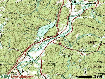
Points of interest:
Notable locations in Orford: Mount Cube Ski Touring Center (A), Camp Weston (B), Dartmouth Outing Club Camp (C), Moosilauke Camp (D), Orford Volunteer Fire Department (E). Display/hide their locations on the map
Church in Orford: Orford Congregational Church (A). Display/hide its location on the map
Lakes and swamps: Upper Baker Pond (A), Indian Pond (B), Mason Pond (C), Mud Turtle Pond (D), Pickerel Pond (E), Reeds Marsh (F). Display/hide their locations on the map
Streams, rivers, and creeks: Brackett Brook (A), South Branch Jacobs Brook (B), North Branch Jacobs Brook (C), Mousley Brook (D), Clough Brook (E), Archertown Brook (F). Display/hide their locations on the map
Park in Orford: Orford Street Historic District (1). Display/hide its location on the map
Hotels: White Goose Inn (422 Route 10) (1), Ivey Marshall J & Renee II (Route 10) (2). Display/hide their approximate locations on the map
Drinking water stations with addresses in Orford and their reported violations in the past:
WESTSHIRE ELEMENTARY SCHOOL (Serves VT, Population served: 131, Groundwater):Past health violations:ORFORD VILLAGE DIST (Population served: 128, Groundwater):Past monitoring violations:
- MCL, Monthly (TCR) - In OCT-2008, Contaminant: Coliform. Follow-up actions: St Boil Water Order (OCT-10-2008), St Formal NOV issued (OCT-10-2008), St Tech Assistance Visit (OCT-10-2008), St Public Notif requested (OCT-10-2008), St Compliance achieved (JAN-29-2010)
- MCL, Monthly (TCR) - In SEP-2008, Contaminant: Coliform. Follow-up actions: St Boil Water Order (SEP-17-2008), St Formal NOV issued (SEP-17-2008), St Tech Assistance Visit (SEP-17-2008), St Public Notif requested (SEP-17-2008), St Compliance achieved (JAN-29-2010)
- MCL, Monthly (TCR) - In AUG-2008, Contaminant: Coliform. Follow-up actions: St Boil Water Order (AUG-18-2008), St Formal NOV issued (AUG-18-2008), St Tech Assistance Visit (AUG-18-2008), St Public Notif requested (AUG-18-2008), St Compliance achieved (JAN-29-2010)
- MCL, Monthly (TCR) - In AUG-2007, Contaminant: Coliform. Follow-up actions: St Boil Water Order (AUG-10-2007), St Formal NOV issued (AUG-10-2007), St Tech Assistance Visit (AUG-10-2007), St Public Notif requested (AUG-10-2007), St Public Notif received (OCT-18-2007), St Compliance achieved (JAN-29-2010)
- MCL, Monthly (TCR) - In AUG-2006, Contaminant: Coliform. Follow-up actions: St Tech Assistance Visit (AUG-25-2006), St Boil Water Order (AUG-25-2006), St Formal NOV issued (AUG-25-2006), St Public Notif requested (AUG-25-2006), St Public Notif received (AUG-28-2006), St Compliance achieved (NOV-06-2006)
- MCL, Monthly (TCR) - In JUL-2006, Contaminant: Coliform. Follow-up actions: St Tech Assistance Visit (JUL-19-2006), St Boil Water Order (JUL-19-2006), St Formal NOV issued (JUL-19-2006), St Public Notif requested (JUL-19-2006), St Public Notif received (JUL-27-2006), St Compliance achieved (NOV-06-2006)
- 3 other older health violations
- One routine major monitoring violation
- One regular monitoring violation
Past health violations:Past monitoring violations:
- MCL, Monthly (TCR) - In JUL-2012, Contaminant: Coliform. Follow-up actions: St Public Notif requested (JUL-31-2012), St Violation/Reminder Notice (JUL-31-2012), St Public Notif received (AUG-07-2012), St Compliance achieved (FEB-13-2013)
- MCL, Monthly (TCR) - In OCT-2007, Contaminant: Coliform. Follow-up actions: St Public Notif requested (OCT-25-2007), St Violation/Reminder Notice (OCT-25-2007), St Public Notif received (NOV-01-2007), St Compliance achieved (MAY-07-2008)
- OCCT/SOWT Treatment Installation/Demonstration - In DEC-01-2005, Contaminant: Lead and Copper Rule. Follow-up actions: St Public Notif requested (DEC-05-2005), St Violation/Reminder Notice (DEC-05-2005), St Public Notif received (JAN-19-2006), St Compliance achieved (MAY-14-2007)
- Monitoring and Reporting (DBP) - Between JUL-01-2012 and OCT-01-2012, Contaminant: Total Haloacetic Acids (HAA5). Follow-up actions: St Public Notif requested (OCT-25-2012), St Violation/Reminder Notice (OCT-25-2012), St Public Notif received (NOV-01-2012), St Compliance achieved (NOV-26-2012)
- Monitoring and Reporting (DBP) - Between JUL-01-2012 and OCT-01-2012, Contaminant: TTHM. Follow-up actions: St Public Notif requested (OCT-25-2012), St Violation/Reminder Notice (OCT-25-2012), St Public Notif received (NOV-01-2012), St Compliance achieved (NOV-26-2012)
| This town: | 2.3 people |
| New Hampshire: | 2.5 people |
| This town: | 64.7% |
| Whole state: | 66.3% |
| This town: | 7.5% |
| Whole state: | 8.3% |
Likely homosexual households (counted as self-reported same-sex unmarried-partner households)
- Lesbian couples: 0.4% of all households
- Gay men: 0.2% of all households
| This town: | 5.5% |
| Whole state: | 6.5% |
| This town: | 2.8% |
| Whole state: | 2.8% |
For population 15 years and over in Orford:

- Never married: 21.0%
- Now married: 63.2%
- Separated: 0.1%
- Widowed: 6.0%
- Divorced: 9.7%
For population 25 years and over in Orford:
- High school or higher: 91.2%
- Bachelor's degree or higher: 37.7%
- Graduate or professional degree: 17.4%
- Unemployed: 2.1%
- Mean travel time to work (commute): 27.6 minutes


| Here: | 11.0 |
| New Hampshire average: | 10.9 |


Graphs represent county-level data. Detailed 2008 Election Results
Religion statistics for Orford, NH (based on Grafton County data)


| Religion | Adherents | Congregations |
|---|---|---|
| Catholic | 9,503 | 12 |
| Mainline Protestant | 7,832 | 57 |
| Evangelical Protestant | 1,494 | 29 |
| Other | 1,320 | 11 |
| None | 68,969 | - |
Food Environment Statistics:
| This county: | 3.87 / 10,000 pop. |
| State: | 2.14 / 10,000 pop. |
| Here: | 0.23 / 10,000 pop. |
| New Hampshire: | 0.15 / 10,000 pop. |
| Grafton County: | 1.29 / 10,000 pop. |
| New Hampshire: | 1.78 / 10,000 pop. |
| Here: | 6.45 / 10,000 pop. |
| New Hampshire: | 4.02 / 10,000 pop. |
| Here: | 14.41 / 10,000 pop. |
| New Hampshire: | 9.70 / 10,000 pop. |
| This county: | 7.2% |
| New Hampshire: | 7.6% |
| Here: | 22.9% |
| State: | 24.4% |
| Grafton County: | 15.9% |
| State: | 15.9% |
Strongest AM radio stations in Orford:
- WTWN (1100 AM; daytime; 5 kW; WELLS RIVER, VT; Owner: PUFFER BROADCASTING, INC.)
- WPNH (1300 AM; 5 kW; PLYMOUTH, NH; Owner: NORTHEAST COMMUNICATIONS CORPORATION)
- WNTK (1020 AM; 10 kW; NEWPORT, NH; Owner: KOOR COMMUNICATIONS, INC.)
- WRKO (680 AM; 50 kW; BOSTON, MA; Owner: ENTERCOM BOSTON LICENSE, LLC)
- WNNZ (640 AM; 50 kW; WESTFIELD, MA; Owner: CLEAR CHANNEL BROADCASTING LICENSES, INC.)
- WCHP (760 AM; 35 kW; CHAMPLAIN, NY; Owner: CHAMPLAIN RADIO, INC.)
- WCRN (830 AM; 50 kW; WORCESTER, MA; Owner: CARTER BROADCASTING CORPORATION)
- WDEV (550 AM; 5 kW; WATERBURY, VT; Owner: RADIO VERMONT, INC.)
- WEEI (850 AM; 50 kW; BOSTON, MA; Owner: ENTERCOM BOSTON LICENSE, LLC)
- WGY (810 AM; 50 kW; SCHENECTADY, NY; Owner: CLEAR CHANNEL BROADCASTING LICENSES, INC.)
- WKOX (1200 AM; 50 kW; FRAMINGHAM, MA; Owner: CAPSTAR TX LIMITED PARTNERSHIP)
- WBZ (1030 AM; 50 kW; BOSTON, MA; Owner: INFINITY BROADCASTING OPERATIONS, INC.)
- WBIX (1060 AM; 40 kW; NATICK, MA; Owner: LANGER BROADCASTING CORPORATION)
Strongest FM radio stations in Orford:
- WEVH (91.3 FM; HANOVER, NH; Owner: NEW HAMPSHIRE PUBLIC RADIO INC)
- WPNH-FM (100.1 FM; PLYMOUTH, NH; Owner: NORTHEAST COMMUNICATIONS CORPORATION)
- WVFM (105.7 FM; CAMPTON, NH; Owner: DEVON BROADCASTING COMPANY, INC.)
- WPKQ (103.7 FM; NORTH CONWAY, NH; Owner: CITADEL BROADCASTING COMPANY)
- WHOM (94.9 FM; MT. WASHINGTON, NH; Owner: CITADEL BROADCASTING COMPANY)
- WHDQ (106.1 FM; CLAREMONT, NH; Owner: GREAT NORTHERN RADIO, L.L.C.)
- WEBK (105.3 FM; KILLINGTON, VT; Owner: 6 JOHNSON ROAD LICENSES, INC.)
- WJJR (98.1 FM; RUTLAND, VT; Owner: 6 JOHNSON ROAD LICENSES, INC.)
- WZRT (97.1 FM; RUTLAND, VT; Owner: CAPSTAR TX LIMITED PARTNERSHIP)
- WVPR (89.5 FM; WINDSOR, VT; Owner: VERMONT PUBLIC RADIO)
- WSCY (106.9 FM; MOULTONBOROUGH, NH; Owner: NORTHEAST COMMUNICATIONS CORPORATION)
- WGLV (91.7 FM; WOODSTOCK, VT; Owner: CHRISTIAN MINISTRIES INC)
- WHDQ-FM1 (106.1 FM; RUTLAND, VT; Owner: GREAT NORTHERN RADIO, L.L.C.)
- WDEV-FM (96.1 FM; WARREN, VT; Owner: RADIO VERMONT, INC.)
- WRJT (103.1 FM; ROYALTON, VT; Owner: LISBON COMMUNICATIONS, INC.)
- WCVT (101.7 FM; STOWE, VT; Owner: RADIO VERMONT CLASSICS, L.L.C.)
- WGMT (97.7 FM; LYNDON, VT; Owner: VERMONT BROADCAST ASSOCIATES, INC.)
- WVPS (107.9 FM; BURLINGTON, VT; Owner: VERMONT PUBLIC RADIO)
- WEZF (92.9 FM; BURLINGTON, VT; Owner: CAPSTAR TX LIMITED PARTNERSHIP)
- WLKC (103.3 FM; WATERBURY, VT; Owner: RADIO BROADCASTING SERVICES, INC.)
TV broadcast stations around Orford:
- W15BK (Channel 15; HANOVER, NH; Owner: UNIVERSITY OF NEW HAMPSHIRE)
Orford fatal accident list:
May 9, 2005 07:35 PM, Sr-10, Sawyer Brook Rd, Lat: 43.897940, Lon: -72.138690, Vehicles: 1, Persons: 2, Fatalities: 1
Aug 25, 1992 10:20 AM, Sr25a, Vehicles: 1, Persons: 2, Fatalities: 1
Nov 15, 1987 03:53 PM, 2309000000, Vehicles: 1, Persons: 1, Fatalities: 1, Drunk persons involved: 1
Jun 7, 1976 00:45 AM, Vehicles: 1, Persons: 1, Fatalities: 1, Drunk persons involved: 1
Jun 7, 1975 00:45 AM, Vehicles: 1, Persons: 1, Fatalities: 1, Drunk persons involved: 1
- National Bridge Inventory (NBI) Statistics
- 17Number of bridges
- 105ft / 31.8mTotal length
- $53,414,000Total costs
- 8,998Total average daily traffic
- 575Total average daily truck traffic
- 13,307Total future (year 2042) average daily traffic

- New bridges - historical statistics
- 31920-1929
- 51930-1939
- 21940-1949
- 11950-1959
- 11990-1999
- 12000-2009
- 32010-2019
- 12020-2022
FCC Registered Antenna Towers:
3- PETER M CONNOLLY, 3.3 Miles Ne Of Ordfordville On Dame Hill Road (Lat: 43.900556 Lon: -72.041111), Type: 29.0, Overall height: 24.4 m, Registrant: United States Cellular Corporation, Chica-go, Phone: (773) 399-8900
- Mark L Gartley, 3.3 Miles Ne Of Ordfordville On Dame Hill Road (Lat: 43.900556 Lon: -72.041111), Type: 29.0, Overall height: 24.4 m, Registrant: Holland & Knight LLP, Pconnoll@hklaw.Com, , Washi-ngton, Phone: (202) 862-5989
- 3.3 Miles Ne Of Ordfordville On Dame Hill Road (Lat: 43.900556 Lon: -72.041111), Type: 29.0, Overall height: 24.4 m, Registrant: United States Cellular Corporation, Glenn.Werner@koteen.Com, , Washi-ngton, Phone: (202) 467-5700
FCC Registered Broadcast Land Mobile Towers:
3- Call Sign: KA66582,
Assigned Frequencies: 10525.0 MHz, 24150.0 MHz, Grant Date: 05/04/2000, Expiration Date: 05/04/2005, Cancellation Date: 07/09/2005, Certifier: Harold R Jarvis, Registrant: Orford, Town Of, Rt 25a, Orford, NH 03777, Phone: (603) 353-4252
- Jct Of Indian Pond Road And Grimes Hill Road (Lat: 43.925806 Lon: -72.058583), Type: Upole, Structure height: 13 m, Overall height: 15 m, Call Sign: WQOH836,
Assigned Frequencies: 48.9800 MHz, Grant Date: 09/30/2011, Expiration Date: 09/30/2021, Cancellation Date: 02/04/2015, Certifier: Robert Armstrong, Registrant: New Hampshire Electric Cooperative, Inc., 579 Tenney Mtn Hwy, Plymouth, NH 03264, Phone: (603) 536-8811, Fax: (603) 536-8687, Email:
- Lat: 43.900361 Lon: -72.124278, Call Sign: WRBV966,
Assigned Frequencies: 153.815 MHz, Grant Date: 07/05/2018, Expiration Date: 07/05/2028, Certifier: John Adams, Registrant: Ossipee Mountain Electronics, Post Office Box 950, Moultonboro, NH 03254-0950, Phone: (603) 476-5581, Fax: (603) 476-5587, Email:
FCC Registered Amateur Radio Licenses:
9 (See the full list of FCC Registered Amateur Radio Licenses in Orford)FAA Registered Aircraft:
1- Aircraft: ENSTROM F-28F (Category: Land, Seats: 3, Weight: Up to 12,499 Pounds), Engine: Reciprocating
N-Number: 110PD, N110PD, N-110PD, Serial Number: 768, Certificate Issue Date: 02/02/2007
Registrant (Individual): Gregory W Landgraf, 104 Upper Stonehouse Mountain Rd, Orford, NH 03777
Deregistered: Yes
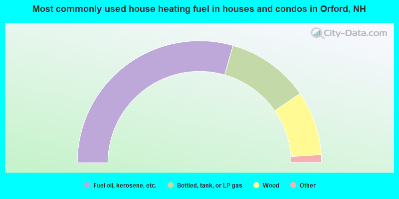
- 58.8%Fuel oil, kerosene, etc.
- 21.9%Bottled, tank, or LP gas
- 17.1%Wood
- 1.6%Electricity
- 0.5%Other fuel
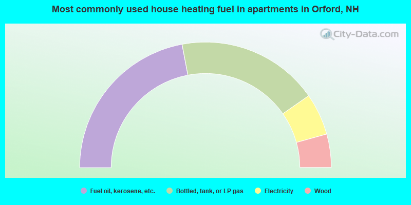
- 44.1%Fuel oil, kerosene, etc.
- 36.6%Bottled, tank, or LP gas
- 10.8%Electricity
- 8.6%Wood
Orford compared to New Hampshire state average:
- Unemployed percentage significantly below state average.
- Black race population percentage below state average.
- Hispanic race population percentage significantly below state average.
- Foreign-born population percentage significantly below state average.
- Length of stay since moving in significantly above state average.
- Number of rooms per house significantly below state average.
- House age significantly below state average.

|
|
Total of 18 patent applications in 2008-2024.