Oakport, Minnesota
Submit your own pictures of this place and show them to the world
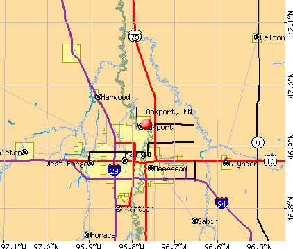
- OSM Map
- General Map
- Google Map
- MSN Map
Population change since 2000: +4.0%
| Males: 771 | |
| Females: 616 |
| Median resident age: | 42.9 years |
| Minnesota median age: | 39.0 years |
Zip codes: 56560.
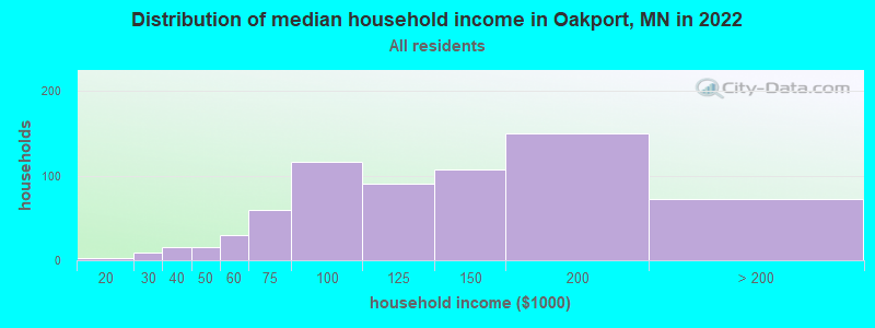
| Oakport: | $134,251 |
| MN: | $82,338 |
Estimated per capita income in 2022: $58,363 (it was $22,506 in 2000)
Oakport CDP income, earnings, and wages data
Estimated median house or condo value in 2022: $340,680 (it was $115,200 in 2000)
| Oakport: | $340,680 |
| MN: | $314,600 |
Mean prices in 2022: all housing units: $350,809; detached houses: $348,576
Detailed information about poverty and poor residents in Oakport, MN


- 1,30791.5%White alone
- 211.5%Two or more races
- 90.6%Black alone
- 70.5%Hispanic
- 20.1%American Indian alone
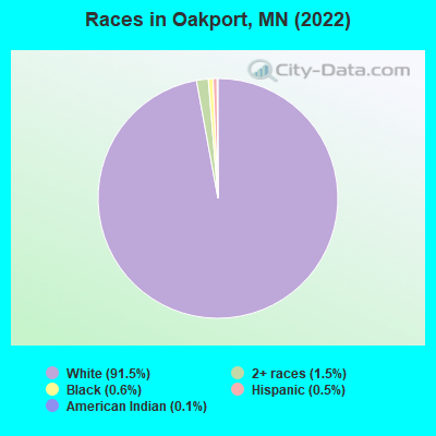
Races in Oakport detailed stats: ancestries, foreign born residents, place of birth
 Recent articles from our blog. Our writers, many of them Ph.D. graduates or candidates, create easy-to-read articles on a wide variety of topics.

Latest news from Oakport, MN collected exclusively by city-data.com from local newspapers, TV, and radio stations
Ancestries: Norwegian (34.4%), German (21.7%), Greek (8.3%), European (6.9%), American (5.4%), Swedish (3.3%).
Current Local Time: CST time zone
Land area: 3.04 square miles.
Population density: 457 people per square mile (low).
6 residents are foreign born
| This place: | 0.4% |
| Minnesota: | 100.0% |
Median real estate property taxes paid for housing units with mortgages in 2022: $3,092 (1.0%)
Median real estate property taxes paid for housing units with no mortgage in 2022: $3,383 (1.1%)
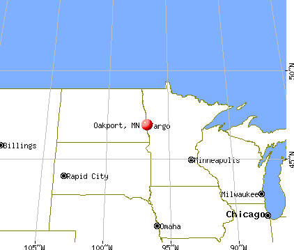
Nearest city with pop. 50,000+: Fargo, ND  (4.9 miles , pop. 90,599).
Nearest city with pop. 200,000+: Minneapolis, MN (216.5 miles , pop. 382,618).
Nearest city with pop. 1,000,000+: Chicago, IL (570.3 miles , pop. 2,896,016).
Nearest cities:
), ), Latitude: 46.94 N, Longitude: 96.77 W

| Here: | 1.9% |
| Minnesota: | 2.6% |

- Educational services (14.3%)
- Construction (12.0%)
- Health care (10.7%)
- Finance & insurance (8.0%)
- Public administration (5.6%)
- Professional, scientific, technical services (3.8%)
- Food & beverage stores (3.0%)

- Construction (22.0%)
- Educational services (8.5%)
- Public administration (8.0%)
- Professional, scientific, technical services (5.2%)
- Food (4.4%)
- Finance & insurance (4.1%)
- Motor vehicle & parts dealers (3.6%)

- Educational services (19.9%)
- Health care (18.3%)
- Finance & insurance (11.9%)
- Social assistance (5.9%)
- Department & other general merchandise stores (3.8%)
- Public administration (3.2%)
- Food & beverage stores (3.0%)

- Other management occupations, except farmers and farm managers (5.0%)
- Other office and administrative support workers, including supervisors (4.2%)
- Registered nurses (3.8%)
- Preschool, kindergarten, elementary, and middle school teachers (3.7%)
- Secretaries and administrative assistants (3.4%)
- Other sales and related occupations, including supervisors (3.3%)
- Other production occupations, including supervisors (3.0%)

- Other management occupations, except farmers and farm managers (8.0%)
- Supervisors, construction and extraction workers (5.2%)
- Construction traders workers except carpenters, electricians, painters, plumbers, and construction laborers (4.7%)
- Other production occupations, including supervisors (4.1%)
- Electricians (3.8%)
- Sales representatives, services, wholesale and manufacturing (3.8%)
- Electrical equipment mechanics and other installation, maintenance, and repair workers, including supervisors (3.8%)

- Registered nurses (7.5%)
- Secretaries and administrative assistants (5.9%)
- Other office and administrative support workers, including supervisors (5.9%)
- Child care workers (5.4%)
- Preschool, kindergarten, elementary, and middle school teachers (5.1%)
- Information and record clerks, except customer service representatives (4.6%)
- Bookkeeping, accounting, and auditing clerks (3.8%)
Average climate in Oakport, Minnesota
Based on data reported by over 4,000 weather stations


(lower is better)

Air Quality Index (AQI) level in 2023 was 122. This is significantly worse than average.
| City: | 122 |
| U.S.: | 73 |

Particulate Matter (PM10) [µg/m3] level in 2019 was 14.4. This is better than average. Closest monitor was 2.2 miles away from the city center.
| City: | 14.4 |
| U.S.: | 19.2 |

Particulate Matter (PM2.5) [µg/m3] level in 2023 was 13.9. This is significantly worse than average. Closest monitor was 4.2 miles away from the city center.
| City: | 13.9 |
| U.S.: | 8.1 |
Tornado activity:
Oakport-area historical tornado activity is near Minnesota state average. It is 1% greater than the overall U.S. average.
On 6/28/1975, a category F4 (max. wind speeds 207-260 mph) tornado 4.2 miles away from the Oakport place center caused between $50,000 and $500,000 in damages.
On 6/20/1957, a category F5 (max. wind speeds 261-318 mph) tornado 25.8 miles away from the place center killed 10 people and injured 103 people and caused between $5,000,000 and $50,000,000 in damages.
Earthquake activity:
Oakport-area historical earthquake activity is significantly above Minnesota state average. It is 19% smaller than the overall U.S. average.On 7/9/1975 at 14:54:15, a magnitude 4.6 (4.6 MB, Class: Light, Intensity: IV - V) earthquake occurred 94.2 miles away from Oakport center
On 6/5/1993 at 01:24:53, a magnitude 4.1 (4.1 LG, Depth: 6.2 mi) earthquake occurred 90.1 miles away from the city center
On 8/18/1959 at 06:37:13, a magnitude 7.7 (7.7 UK, Class: Major, Intensity: VIII - XII) earthquake occurred 689.0 miles away from the city center, causing $26,000,000 total damage
On 3/4/1983 at 06:32:18, a magnitude 4.6 (4.4 MB, 4.6 LG, 4.4 ML) earthquake occurred 227.6 miles away from the city center
On 10/20/1995 at 15:57:18, a magnitude 3.7 (3.7 LG, Depth: 3.1 mi, Class: Light, Intensity: II - III) earthquake occurred 79.5 miles away from the city center
On 10/25/1990 at 06:25:25, a magnitude 3.9 (3.6 MB, 3.9 LG, Depth: 3.1 mi) earthquake occurred 232.5 miles away from Oakport center
Magnitude types: regional Lg-wave magnitude (LG), body-wave magnitude (MB), local magnitude (ML)
Natural disasters:
The number of natural disasters in Clay County (27) is a lot greater than the US average (15).Major Disasters (Presidential) Declared: 21
Emergencies Declared: 4
Causes of natural disasters: Floods: 22, Storms: 12, Tornadoes: 5, Winds: 3, Winter Storms: 3, Blizzard: 1, Drought: 1, Heavy Rain: 1, Hurricane: 1, Snow: 1, Other: 1 (Note: some incidents may be assigned to more than one category).

Hospitals and medical centers near Oakport:
- FARGO VA MEDICAL CENTER (Hospital, Acute Care - Veterans Administration, about 3 miles away; FARGO, ND)
- ROSEWOOD ON BROADWAY (Nursing Home, about 4 miles away; FARGO, ND)
- MERITCARE HOS SAME DAY SURGERY (Hospital, about 4 miles away; FARGO, ND)
- ST ANSGAR HOSPITAL (Hospital, about 4 miles away; MOORHEAD, MN)
- SANFORD MEDICAL CENTER FARGO Acute Care Hospitals (about 4 miles away; FARGO, ND)
- GOLDEN LIVINGCENTER - MOORHEAD (Nursing Home, about 5 miles away; MOORHEAD, MN)
- BETHANY ON UNIVERSITY (Nursing Home, about 5 miles away; FARGO, ND)
Colleges/universities with over 2000 students nearest to Oakport:
- North Dakota State University-Main Campus (about 4 miles; Fargo, ND; Full-time enrollment: 12,680)
- Minnesota State University-Moorhead (about 5 miles; Moorhead, MN; FT enrollment: 6,096)
- Concordia College at Moorhead (about 6 miles; Moorhead, MN; FT enrollment: 2,767)
- North Dakota State College of Science (about 47 miles; Wahpeton, ND; FT enrollment: 2,318)
- Minnesota State Community and Technical College (about 55 miles; Fergus Falls, MN; FT enrollment: 4,863)
- University of North Dakota (about 70 miles; Grand Forks, ND; FT enrollment: 12,858)
- Northland Community and Technical College (about 87 miles; Thief River Falls, MN; FT enrollment: 2,717)
Points of interest:
Church in Oakport: Faith Mennonite Church (A). Display/hide its location on the map
| This place: | 2.9 people |
| Minnesota: | 2.5 people |
| This place: | 87.1% |
| Whole state: | 64.6% |
| This place: | 3.1% |
| Whole state: | 6.9% |
No gay or lesbian households reported
For population 15 years and over in Oakport:

- Never married: 22.3%
- Now married: 67.3%
- Separated: 0.0%
- Widowed: 3.2%
- Divorced: 7.1%
For population 25 years and over in Oakport:
- High school or higher: 97.9%
- Bachelor's degree or higher: 39.6%
- Graduate or professional degree: 11.9%
- Unemployed: 3.5%
- Mean travel time to work (commute): 17.6 minutes


| Here: | 8.4 |
| Minnesota average: | 10.9 |
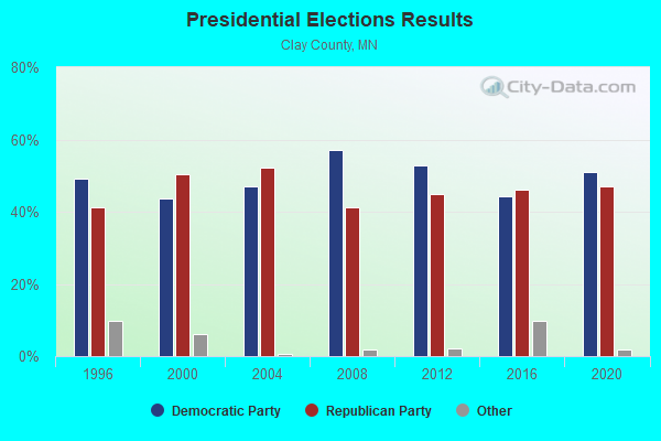
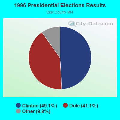
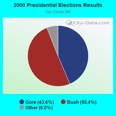
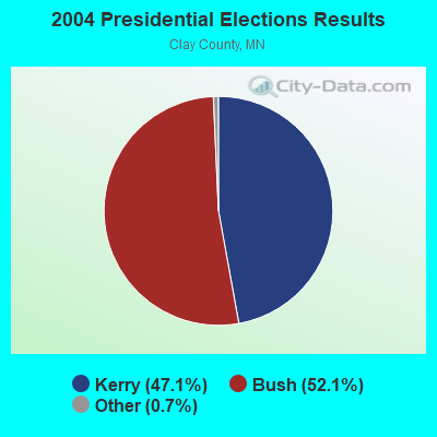
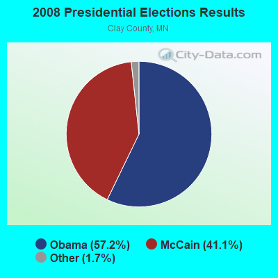
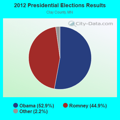
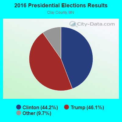
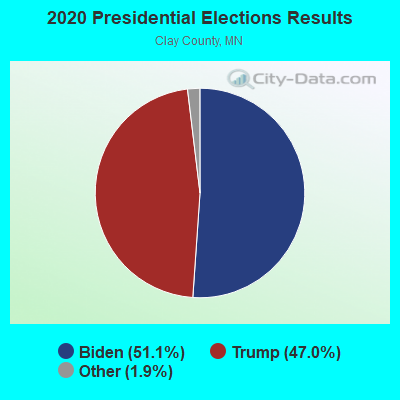
Graphs represent county-level data. Detailed 2008 Election Results
Religion statistics for Oakport, MN (based on Clay County data)

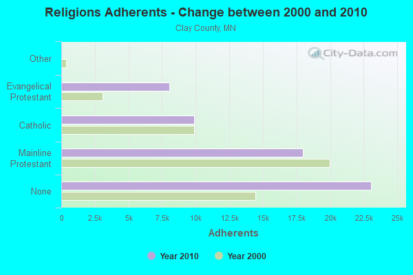
| Religion | Adherents | Congregations |
|---|---|---|
| Mainline Protestant | 17,959 | 32 |
| Catholic | 9,900 | 11 |
| Evangelical Protestant | 8,055 | 30 |
| Other | 24 | 1 |
| None | 23,061 | - |
Food Environment Statistics:
| Clay County: | 1.28 / 10,000 pop. |
| Minnesota: | 1.83 / 10,000 pop. |
| Clay County: | 0.18 / 10,000 pop. |
| Minnesota: | 0.49 / 10,000 pop. |
| Here: | 3.66 / 10,000 pop. |
| Minnesota: | 3.90 / 10,000 pop. |
| Clay County: | 4.03 / 10,000 pop. |
| State: | 6.98 / 10,000 pop. |
| This county: | 6.4% |
| State: | 6.5% |
| Clay County: | 26.5% |
| Minnesota: | 25.9% |
| Here: | 11.6% |
| Minnesota: | 13.0% |
Strongest AM radio stations in Oakport:
- WDAY (970 AM; 5 kW; FARGO, ND; Owner: FORUM COMMUNICATIONS COMPANY)
- KQWB (1660 AM; 10 kW; WEST FARGO, ND; Owner: MONTEREY LICENSES, LLC)
- KFNW (1200 AM; 10 kW; WEST FARGO, ND; Owner: NORTHWESTERN COLLEGE)
- KVOX (1280 AM; 5 kW; MOORHEAD, MN; Owner: CAPSTAR TX LIMITED PARTNERSHIP)
- KFGO (790 AM; 5 kW; FARGO, ND; Owner: CAPSTAR TX LIMITED PARTNERSHIP)
- WWNL (1080 AM; 50 kW; PITTSBURGH, PA; Owner: STEEL CITY RADIO, INC.)
- KPRM (870 AM; 25 kW; PARK RAPIDS, MN; Owner: DE LA HUNT BROADCASTING CORP.)
- KBRF (1250 AM; 10 kW; FERGUS FALLS, MN; Owner: RESULT RADIO, INC.)
- KXMR (710 AM; 50 kW; BISMARCK, ND; Owner: RADIO BISMARCK MANDAN, LLC)
- WEBC (560 AM; 50 kW; DULUTH, MN)
- WCCO (830 AM; 50 kW; MINNEAPOLIS, MN; Owner: INFINITY MEDIA CORPORATION)
- KNOX (1310 AM; 5 kW; GRAND FORKS, ND; Owner: LEIGHTON ENTERPRISES, INC.)
- KSJB (600 AM; 5 kW; JAMESTOWN, ND; Owner: CHESTERMAN COMM. JAMESTOWN, INC.)
Strongest FM radio stations in Oakport:
- KVOX-FM (99.9 FM; MOORHEAD, MN; Owner: MONTEREY LICENSES, LLC)
- KCCM-FM (91.1 FM; MOORHEAD, MN; Owner: MINNESOTA PUBLIC RADIO)
- WDAY-FM (93.7 FM; FARGO, ND; Owner: CAPSTAR TX LIMITED PARTNERSHIP)
- KFNW-FM (97.9 FM; FARGO, ND; Owner: NORTHWESTERN COLLEGE)
- KKBX (101.9 FM; FARGO, ND; Owner: CAPSTAR TX LIMITED PARTNERSHIP)
- KDSU (91.9 FM; FARGO, ND; Owner: NORTH DAKOTA STATE UNIVERSITY)
- KPFX (107.9 FM; FARGO, ND; Owner: MONTEREY LICENSES, LLC)
- KQWB-FM (98.7 FM; MOORHEAD, MN; Owner: MONTEREY LICENSES, LLC)
- KFAB-FM (92.7 FM; KINDRED, ND; Owner: CAPSTAR TX LIMITED PARTNERSHIP)
- KFBN (88.7 FM; FARGO, ND; Owner: FARGO BAPTIST CHURCH)
- KCCD (90.3 FM; MOORHEAD, MN; Owner: MINNESOTA PUBLIC RADIO)
- KLTA (105.1 FM; BRECKENRIDGE, MN; Owner: MONTEREY LICENSES, LLC)
- KRVI (95.1 FM; DETROIT LAKES, MN; Owner: CAPSTAR TX LIMITED PARTNERSHIP)
- KDJZ (100.7 FM; HARWOOD, ND; Owner: TOM INGSTAD NORTH DAKOTA BROADCASTING LLC)
- KDAM (104.7 FM; HOPE, ND; Owner: CLEAR CHANNEL BROADCASTING LICENSES, INC.)
- KEGK (106.9 FM; WAHPETON, ND; Owner: GUDERIAN BROADCASTING, INC.)
TV broadcast stations around Oakport:
- KVRR (Channel 15; FARGO, ND; Owner: RED RIVER BROADCAST CO., LLC)
- KVNJ-LP (Channel 2; FARGO, ND; Owner: G.I.G., INC.)
- WDAY-TV (Channel 6; FARGO, ND; Owner: FORUM COMMUNICATIONS COMPANY)
- KFME (Channel 13; FARGO, ND; Owner: PRAIRIE PUBLIC BROADCASTING, INC.)
- KXJB-TV (Channel 4; VALLEY CITY, ND; Owner: CATAMOUNT BROADCASTING OF FARGO LLC)
- K56ET (Channel 56; FARGO, ND; Owner: TRINITY BROADCASTING NETWORK)
- KVLY-TV (Channel 11; FARGO, ND; Owner: NORTH DAKOTA TELEVISION LICENSE SUB, L.L.C.)
- National Bridge Inventory (NBI) Statistics
- 5Number of bridges
- 200ft / 61.0mTotal length
- $1,000Total costs
- 10,574Total average daily traffic
- 10,610Total future (year 2029) average daily traffic
FCC Registered Microwave Towers:
3- OAKPORT TANK, 2nd Street North (Lat: 46.939750 Lon: -96.775806), Type: Tank, Structure height: 42 m, Call Sign: WQGG794,
Assigned Frequencies: 10618.7 MHz, Grant Date: 01/12/2007, Expiration Date: 01/12/2017, Cancellation Date: 07/11/2007, Certifier: Tim Sanden, Registrant: Comsearch, 19700 Janelia Farm Boulevard, Ashburn, VA 20147, Phone: (703) 726-5500, Fax: (703) 726-5595, Email:
- OAKPORT TANK, Off 2nd Street North (Lat: 46.939750 Lon: -96.775806), Type: Tank, Structure height: 42 m, Call Sign: WQGT397,
Assigned Frequencies: 10618.7 MHz, Grant Date: 01/25/2017, Expiration Date: 04/11/2027, Certifier: Dave Rogness, Registrant: Red River Regional Dispatch Center, 300 Np Avenue Suite #206, Fargo, ND 58102, Phone: (701) 451-7683, Email:
- POLE SITE, 2nd Street N (Lat: 46.936500 Lon: -96.658139), Type: Tank, Structure height: 42.4 m, Call Sign: WQVN565,
Assigned Frequencies: 10855.0 MHz, 10855.0 MHz, 10855.0 MHz, 10855.0 MHz, 10855.0 MHz, 10855.0 MHz, 10855.0 MHz, 10855.0 MHz, Grant Date: 04/07/2015, Expiration Date: 04/07/2025, Certifier: Bill Schwandt, Registrant: Pcs Technologies, Inc., 30 W Water Street, St Paul, MN 55107, Phone: (651) 222-5881, Fax: (651) 228-2645, Email:
| Home Mortgage Disclosure Act Aggregated Statistics For Year 2009 (Based on 1 partial tract) | ||||||||||
| A) FHA, FSA/RHS & VA Home Purchase Loans | B) Conventional Home Purchase Loans | C) Refinancings | D) Home Improvement Loans | F) Non-occupant Loans on < 5 Family Dwellings (A B C & D) | ||||||
|---|---|---|---|---|---|---|---|---|---|---|
| Number | Average Value | Number | Average Value | Number | Average Value | Number | Average Value | Number | Average Value | |
| LOANS ORIGINATED | 5 | $142,136 | 8 | $140,276 | 38 | $147,011 | 5 | $60,246 | 3 | $138,153 |
| APPLICATIONS APPROVED, NOT ACCEPTED | 0 | $0 | 1 | $88,570 | 3 | $159,460 | 0 | $0 | 0 | $0 |
| APPLICATIONS DENIED | 0 | $0 | 0 | $0 | 7 | $173,566 | 1 | $134,950 | 3 | $104,590 |
| APPLICATIONS WITHDRAWN | 1 | $109,050 | 2 | $181,535 | 7 | $153,691 | 1 | $162,110 | 0 | $0 |
| FILES CLOSED FOR INCOMPLETENESS | 0 | $0 | 0 | $0 | 1 | $71,440 | 0 | $0 | 0 | $0 |
Detailed HMDA statistics for the following Tracts: 0301.06
| Private Mortgage Insurance Companies Aggregated Statistics For Year 2009 (Based on 1 partial tract) | ||
| A) Conventional Home Purchase Loans | ||
|---|---|---|
| Number | Average Value | |
| LOANS ORIGINATED | 1 | $233,550 |
| APPLICATIONS APPROVED, NOT ACCEPTED | 0 | $0 |
| APPLICATIONS DENIED | 0 | $0 |
| APPLICATIONS WITHDRAWN | 0 | $0 |
| FILES CLOSED FOR INCOMPLETENESS | 0 | $0 |
Detailed PMIC statistics for the following Tracts: 0301.06


- 69.3%Utility gas
- 24.8%Electricity
- 3.8%Bottled, tank, or LP gas
- 1.3%Wood
- 0.8%Fuel oil, kerosene, etc.

- 69.6%Electricity
- 30.4%Utility gas
Oakport compared to Minnesota state average:
- Median household income above state average.
- Unemployed percentage significantly below state average.
- Black race population percentage significantly below state average.
- Hispanic race population percentage significantly below state average.
- Foreign-born population percentage significantly below state average.
- Renting percentage significantly below state average.
- Length of stay since moving in significantly above state average.
- Number of rooms per house above state average.
- House age significantly below state average.
- Number of college students below state average.