Nippa, Kentucky
Submit your own pictures of this place and show them to the world
- OSM Map
- General Map
- Google Map
- MSN Map

| Males: 1,441 | |
| Females: 1,472 |
| Median resident age: | 36.4 years |
| Kentucky median age: | 35.9 years |
Zip code: 41232
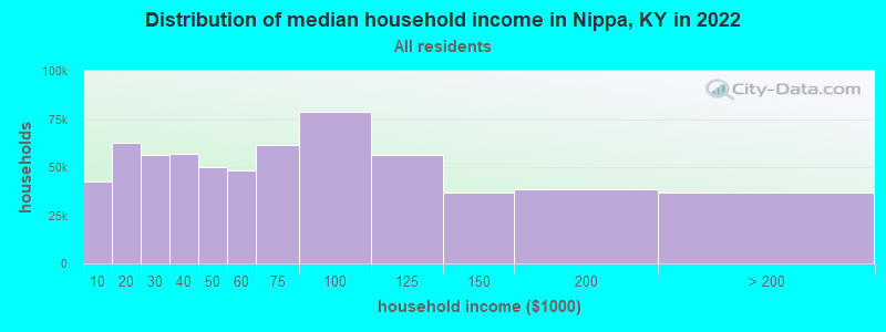
| Nippa: | $40,485 |
| KY: | $59,341 |
Estimated per capita income in 2022: $19,169 (it was $11,585 in 2000)
Nippa CCD income, earnings, and wages data
Estimated median house or condo value in 2022: $115,401 (it was $40,700 in 2000)
| Nippa: | $115,401 |
| KY: | $196,300 |
Mean prices in 2022: all housing units: $182,946; detached houses: $219,470; townhouses or other attached units: $79,879; mobile homes: $69,598
Detailed information about poverty and poor residents in Nippa, KY


- 2,81298.8%White alone
- 140.5%Hispanic
- 100.4%Asian alone
- 70.2%Two or more races
- 20.07%Black alone

Races in Nippa detailed stats: ancestries, foreign born residents, place of birth
According to our research of Kentucky and other state lists, there were 4 registered sex offenders living in Nippa, Kentucky as of June 03, 2024.
The ratio of all residents to sex offenders in Nippa is 728 to 1.
The ratio of registered sex offenders to all residents in this city is lower than the state average.
 Recent articles from our blog. Our writers, many of them Ph.D. graduates or candidates, create easy-to-read articles on a wide variety of topics.
Current Local Time: EST time zone
Land area: 40.4 square miles.
Population density: 72 people per square mile (very low).

| Nippa CCD: | 0.9% ($362) |
| Kentucky: | 0.8% ($610) |
Nearest city with pop. 50,000+: Huntington, WV  (39.5 miles , pop. 51,475).
Nearest city with pop. 200,000+: Fayette, KY (94.1 miles , pop. 260,512).
Nearest city with pop. 1,000,000+: Chicago, IL (376.3 miles , pop. 2,896,016).
Nearest cities:
), ), ), ), ), Latitude: 37.91 N, Longitude: 82.78 W
Area code commonly used in this area: 606

| Here: | 6.3% |
| Kentucky: | 3.8% |

- Health care (12.1%)
- Educational services (11.0%)
- Mining, quarrying, oil & gas extraction (9.5%)
- Accommodation & food services (7.9%)
- Construction (6.2%)
- Agriculture, forestry, fishing & hunting (4.9%)
- Food & beverage stores (4.3%)

- Mining, quarrying, oil & gas extraction (18.2%)
- Construction (11.8%)
- Agriculture, forestry, fishing & hunting (8.5%)
- Educational services (5.5%)
- Administrative & support & waste management services (4.5%)
- Motor vehicle & parts dealers (4.1%)
- Health care (4.1%)

- Health care (20.9%)
- Educational services (17.1%)
- Accommodation & food services (13.8%)
- Food & beverage stores (8.1%)
- Department & other general merchandise stores (6.4%)
- Professional, scientific, technical services (5.2%)
- Gasoline stations (5.0%)

- Building and grounds cleaning and maintenance occupations (7.3%)
- Other sales and related occupations, including supervisors (5.1%)
- Cashiers (4.4%)
- Extraction workers (4.4%)
- Fishing, hunting, and forestry occupations (4.4%)
- Driver/sales workers and truck drivers (4.3%)
- Construction traders workers except carpenters, electricians, painters, plumbers, and construction laborers (4.2%)

- Building and grounds cleaning and maintenance occupations (8.5%)
- Fishing, hunting, and forestry occupations (8.5%)
- Extraction workers (8.5%)
- Driver/sales workers and truck drivers (8.3%)
- Construction traders workers except carpenters, electricians, painters, plumbers, and construction laborers (8.1%)
- Electrical equipment mechanics and other installation, maintenance, and repair workers, including supervisors (7.9%)
- Other material moving workers, except laborers (7.0%)

- Cashiers (9.3%)
- Other sales and related occupations, including supervisors (7.0%)
- Preschool, kindergarten, elementary, and middle school teachers (6.8%)
- Building and grounds cleaning and maintenance occupations (6.0%)
- Nursing, psychiatric, and home health aides (5.0%)
- Food and beverage serving workers, except waiters and waitresses (5.0%)
- Information and record clerks, except customer service representatives (4.5%)
Average climate in Nippa, Kentucky
Based on data reported by over 4,000 weather stations


Tornado activity:
Nippa-area historical tornado activity is significantly below Kentucky state average. It is 64% smaller than the overall U.S. average.
On 4/23/1968, a category F5 (max. wind speeds 261-318 mph) tornado 54.7 miles away from the Nippa place center killed 7 people and injured 93 people and caused between $500,000 and $5,000,000 in damages.
On 4/8/1965, a category F3 (max. wind speeds 158-206 mph) tornado 32.3 miles away from the place center injured 3 people and caused between $50,000 and $500,000 in damages.
Earthquake activity:
Nippa-area historical earthquake activity is significantly above Kentucky state average. It is 23% greater than the overall U.S. average.On 7/27/1980 at 18:52:21, a magnitude 5.2 (5.1 MB, 4.7 MS, 5.0 UK, 5.2 UK, Class: Moderate, Intensity: VI - VII) earthquake occurred 66.8 miles away from the city center
On 8/23/2011 at 17:51:04, a magnitude 5.8 (5.8 MW, Depth: 3.7 mi) earthquake occurred 264.1 miles away from Nippa center
On 8/9/2020 at 12:07:37, a magnitude 5.1 (5.1 MW, Depth: 4.7 mi) earthquake occurred 135.7 miles away from the city center
On 9/7/1988 at 02:28:09, a magnitude 4.6 (4.5 MB, 4.6 LG, Class: Light, Intensity: IV - V) earthquake occurred 62.2 miles away from the city center
On 4/18/2008 at 09:36:59, a magnitude 5.4 (5.1 MB, 4.8 MS, 5.4 MW, 5.2 MW) earthquake occurred 280.3 miles away from the city center
On 11/2/2006 at 17:53:02, a magnitude 4.3 (4.3 MB, Depth: 0.6 mi) earthquake occurred 67.9 miles away from the city center
Magnitude types: regional Lg-wave magnitude (LG), body-wave magnitude (MB), surface-wave magnitude (MS), moment magnitude (MW)
Natural disasters:
The number of natural disasters in Johnson County (35) is a lot greater than the US average (15).Major Disasters (Presidential) Declared: 27
Emergencies Declared: 3
Causes of natural disasters: Floods: 24, Storms: 23, Mudslides: 9, Tornadoes: 9, Landslides: 7, Winter Storms: 6, Winds: 4, Fires: 2, Blizzard: 1, Freeze: 1, Hurricane: 1, Snow: 1, Snowfall: 1, Snowstorm: 1, Other: 1 (Note: some incidents may be assigned to more than one category).
Colleges/universities with over 2000 students nearest to Nippa:
- Big Sandy Community and Technical College (about 16 miles; Prestonsburg, KY; Full-time enrollment: 2,660)
- Ashland Community and Technical College (about 40 miles; Ashland, KY; FT enrollment: 2,482)
- Marshall University (about 41 miles; Huntington, WV; FT enrollment: 11,450)
- Morehead State University (about 41 miles; Morehead, KY; FT enrollment: 7,523)
- Hazard Community and Technical College (about 52 miles; Hazard, KY; FT enrollment: 2,087)
- Shawnee State University (about 59 miles; Portsmouth, OH; FT enrollment: 4,160)
- West Virginia State University (about 64 miles; Institute, WV; FT enrollment: 2,133)
Points of interest:
Churches in Nippa include: Georges Creek United Baptist Church (A), Locust Grove United Baptist Church (B), Belles Chapel (C), Church of Christ (D), Tutor Key Church (E), Baker Branch Church (F), Sugar Grove United Baptist Church (G), Enterprise Church (H). Display/hide their locations on the map
Cemeteries: Castle Cemetery (1), Stambaugh Cemetery (2), Pack and Chandler Cemetery (3). Display/hide their locations on the map
Streams, rivers, and creeks: Dogwood Fork (A), Borders Branch (B), Brafford Fork (C), Browns Fork (D), Well Branch (E), Tick Vanhoose Branch (F), Mary Branch (G), Cave Fork (H), Caudill Branch (I). Display/hide their locations on the map
| This place: | 2.5 people |
| Kentucky: | 2.5 people |
| This place: | 75.4% |
| Whole state: | 66.9% |
| This place: | 3.8% |
| Whole state: | 6.4% |
Likely homosexual households (counted as self-reported same-sex unmarried-partner households)
- Lesbian couples: 0.3% of all households
- Gay men: 0.3% of all households
| This place: | 29.5% |
| Whole state: | 15.8% |
| This place: | 15.3% |
| Whole state: | 6.6% |
For population 15 years and over in Nippa:

- Never married: 18.4%
- Now married: 65.0%
- Separated: 1.9%
- Widowed: 5.7%
- Divorced: 10.9%
For population 25 years and over in Nippa:
- High school or higher: 53.1%
- Bachelor's degree or higher: 4.5%
- Graduate or professional degree: 2.0%
- Unemployed: 9.9%
- Mean travel time to work (commute): 32.0 minutes


| Here: | 15.9 |
| Kentucky average: | 13.8 |
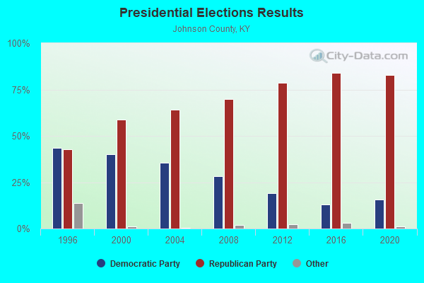
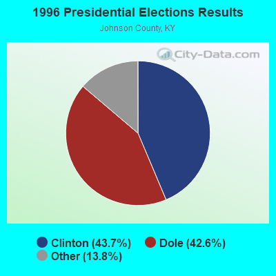
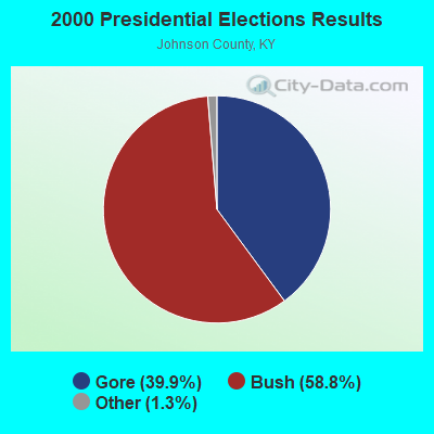

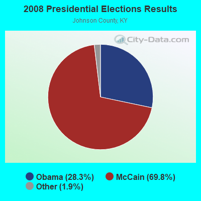
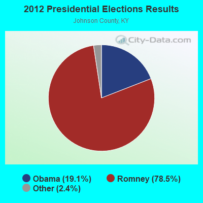
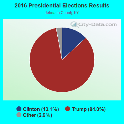
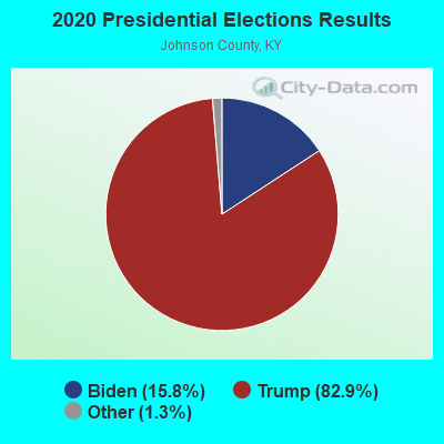
Graphs represent county-level data. Detailed 2008 Election Results
Religion statistics for Nippa, KY (based on Johnson County data)
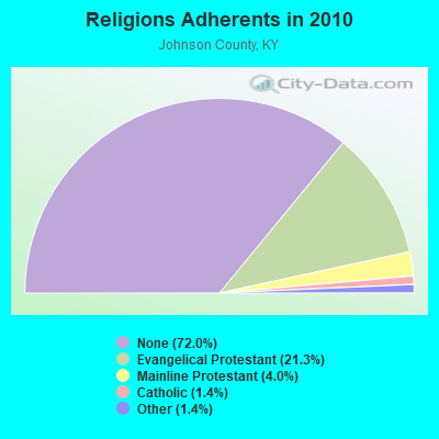
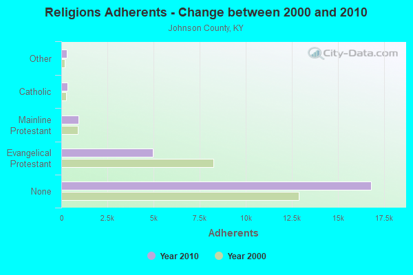
| Religion | Adherents | Congregations |
|---|---|---|
| Evangelical Protestant | 4,977 | 51 |
| Mainline Protestant | 925 | 4 |
| Catholic | 325 | 1 |
| Other | 316 | 2 |
| None | 16,813 | - |
Food Environment Statistics:
| Johnson County: | 1.67 / 10,000 pop. |
| State: | 2.19 / 10,000 pop. |
| Johnson County: | 1.25 / 10,000 pop. |
| State: | 0.74 / 10,000 pop. |
| This county: | 5.42 / 10,000 pop. |
| Kentucky: | 4.36 / 10,000 pop. |
| This county: | 5.00 / 10,000 pop. |
| State: | 5.74 / 10,000 pop. |
| This county: | 10.6% |
| Kentucky: | 11.0% |
| Johnson County: | 36.3% |
| State: | 30.0% |
| Johnson County: | 19.6% |
| Kentucky: | 15.9% |
Strongest AM radio stations in Nippa:
- WKYH (600 AM; 5 kW; PAINTSVILLE, KY; Owner: HIGHLANDS BROADCASTING CORPORATION)
- WDOC (1310 AM; 5 kW; PRESTONSBURG, KY)
- WPRT (960 AM; 5 kW; PRESTONSBURG, KY; Owner: EAST KENTUCKY RADIO NETWORK, INC.)
- WSIP (1490 AM; 1 kW; PAINTSVILLE, KY; Owner: S.I.P. BROADCASTING COMPANY, INC.)
- WTVN (610 AM; 50 kW; COLUMBUS, OH; Owner: CITICASTERS LICENSES, L.P.)
- WVHU (800 AM; 5 kW; HUNTINGTON, WV; Owner: CAPSTAR TX LIMITED PARTNERSHIP)
- WLSI (900 AM; 5 kW; PIKEVILLE, KY; Owner: EAST KENTUCKY BROADCASTING CORPORATION)
- WLW (700 AM; 50 kW; CINCINNATI, OH; Owner: JACOR BROADCASTING CORPORATION)
- WGOH (1370 AM; 5 kW; GRAYSON, KY; Owner: CARTER COUNTY BROADCASTING CO., INC.)
- WRVC (930 AM; 5 kW; HUNTINGTON, WV; Owner: FIFTH AVENUE BROADCASTING COMPANY, INC.)
- WMTC (730 AM; 5 kW; VANCLEVE, KY; Owner: THE KENTUCKY MOUNTAIN HOLINESS ASSN.)
- WEKG (810 AM; daytime; 5 kW; JACKSON, KY; Owner: INTERMOUNTAIN B/CING CO., INC.)
- WKVL (850 AM; daytime; 50 kW; KNOXVILLE, TN; Owner: HORNE RADIO, LLC)
Strongest FM radio stations in Nippa:
- WKLW-FM (94.7 FM; PAINTSVILLE, KY; Owner: B & G BROADCASTING, INC.)
- WSIP-FM (98.9 FM; PAINTSVILLE, KY; Owner: SIP BROADCASTING, INC.)
- WQHY (95.5 FM; PRESTONSBURG, KY; Owner: WDOC, INC.)
- WXLR (104.9 FM; HAROLD, KY; Owner: ADAM D GEARHEART)
- WXKZ-FM (105.3 FM; PRESTONSBURG, KY; Owner: ADAM GEARHEART D/B/A WXLR-FM)
- WDHR (93.1 FM; PIKEVILLE, KY; Owner: EAST KENTUCKY BROADCASTING CORP.)
- WMDJ-FM (100.1 FM; ALLEN, KY; Owner: FLOYD COUNTY BROADCASTING CO., INC.)
- WPKE-FM (103.1 FM; COAL RUN, KY; Owner: EAST KENTUCKY BROADCASTING CORP.)
- WIFX-FM (94.3 FM; JENKINS, KY; Owner: LETCHER COUNTY BROADCASTING, INC)
- WSGS (101.1 FM; HAZARD, KY; Owner: MOUNTAIN BROADCASTING SERVICE, INC.)
- WRLV-FM (106.5 FM; SALYERSVILLE, KY; Owner: WALLINGFORD BROADCASTING COMPANY, INC.)
- WMKY (90.3 FM; MOREHEAD, KY; Owner: MOREHEAD STATE UNIVERSITY)
- WZAQ (92.3 FM; LOUISA, KY; Owner: LOUISA COMMUNICATIONS, INC.)
- WDGG (93.7 FM; ASHLAND, KY; Owner: FIFTH AVENUE B/CASTING COMPANY, INC.)
- WVKM (106.7 FM; MATEWAN, WV; Owner: THREE STATES BROADCASTING CO., INC.)
- WZLK (107.5 FM; VIRGIE, KY; Owner: EAST KENTUCKY BROADCASTING CORPORATION)
- WFGH (90.7 FM; FORT GAY, WV; Owner: WAYNE COUNTY BOARD OF EDUCATION)
- W207AO (89.3 FM; PAINTSVILLE-VAN LEAR, KY; Owner: APPALSHOP, INC.)
TV broadcast stations around Nippa:
- W26BK (Channel 26; TALBERT, KY; Owner: MS COMMUNICATIONS, LLC)
- WUPX-TV (Channel 67; MOREHEAD, KY; Owner: PAXSON LEXINGTON LICENSE, INC.)
- WPBY-TV (Channel 33; HUNTINGTON, WV; Owner: WEST VIRGINIA EDUCATIONAL BROADCASTING AUTHORITY)
- W16BI (Channel 16; TALBERT, KY; Owner: MS COMMUNICATIONS, LLC)
FCC Registered Amateur Radio Licenses:
1- Call Sign: KK4YEK, Licensee ID: L01842331, Grant Date: 02/12/2014, Expiration Date: 02/12/2024, Certifier: Kermit C Van Hoose Jr, Registrant: Kermit C Van Hoose Jr, 499 Rt 1559, Nippa, KY 41240

- 62.5%Electricity
- 14.9%Bottled, tank, or LP gas
- 11.2%Utility gas
- 5.2%Coal or coke
- 3.3%Wood
- 2.3%Fuel oil, kerosene, etc.
- 0.7%No fuel used

- 46.1%Electricity
- 36.6%Fuel oil, kerosene, etc.
- 9.9%Bottled, tank, or LP gas
- 7.3%Wood
Nippa compared to Kentucky state average:
- Median house value below state average.
- Black race population percentage significantly below state average.
- Hispanic race population percentage significantly below state average.
- Median age below state average.
- Foreign-born population percentage significantly below state average.
- Length of stay since moving in significantly above state average.
- Number of rooms per house significantly below state average.
- House age significantly below state average.
- Number of college students below state average.
- Percentage of population with a bachelor's degree or higher significantly below state average.