Montour, New York
Submit your own pictures of this town and show them to the world
- OSM Map
- Google Map
- MSN Map
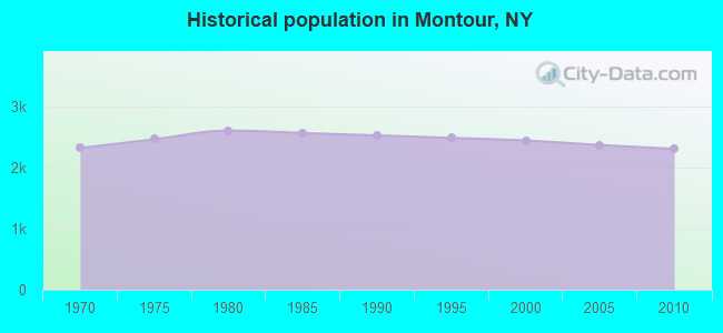
Population change since 2000: -5.6%
 |
| Males: 1,109 | |
| Females: 1,199 |
| Median resident age: | 46.8 years |
| New York median age: | 40.7 years |
Zip codes: 14865.
| Montour: | $56,391 |
| NY: | $79,557 |
Estimated per capita income in 2022: $35,130 (it was $16,983 in 2000)
Montour town income, earnings, and wages data
Estimated median house or condo value in 2022: $151,591 (it was $64,000 in 2000)
| Montour: | $151,591 |
| NY: | $400,400 |
Mean prices in 2022: all housing units: $207,064; detached houses: $214,879; townhouses or other attached units: $157,583; in 2-unit structures: $203,811; in 3-to-4-unit structures: $843,030; in 5-or-more-unit structures: $493,187; mobile homes: $119,131
Detailed information about poverty and poor residents in Montour, NY
Compare current foreclosures near Montour, NY:
| Photo | Address | Area | Beds / Baths | Price | Details |
|---|---|---|---|---|---|

|
#1
Johnson St
Elmira, NY 14901
|
1,406 sq. feet
|
1 baths 3 beds |
show details | |

|
#2
Davis St
Elmira, NY 14901
|
1,963 sq. feet
|
2 baths 3 beds |
show details | |

|
#3
Haradon Rd
Corning, NY 14830
|
1,488 sq. feet
|
3 baths 3 beds |
show details | |

|
#4
Crete Ave
Elmira, NY 14901
|
1,092 sq. feet
|
1 baths 3 beds |
show details | |

|
#5
Iradell Rd
Ithaca, NY 14850
|
1,571 sq. feet
|
1 baths 4 beds |
show details | |

|
#6
Steuben St
Horseheads, NY 14845
|
1,252 sq. feet
|
1 baths 2 beds |
show details | |

|
#7
Breesport Rd
Horseheads, NY 14845
|
2,360 sq. feet
|
1 baths 3 beds |
show details | |

|
#8
John St
Horseheads, NY 14845
|
1,600 sq. feet
|
2 baths 4 beds |
show details | |

|
#9
Deer Run Rd
Newfield, NY 14867
|
1,586 sq. feet
|
2 baths 3 beds |
show details | |

|
#10
County Road 23
Dundee, NY 14837
|
2,270 sq. feet
|
1 baths 3 beds |
show details |
| Photo | Address | Area | Beds / Baths | Price | Details |
|---|---|---|---|---|---|

|
#11
Birch Dr
Corning, NY 14830
|
1,092 sq. feet
|
1 baths 3 beds |
show details | |

|
#12
Watkins Rd
Horseheads, NY 14845
|
2,498 sq. feet
|
1 baths 3 beds |
show details | |

|
#13
Veteran Hill Rd
Horseheads, NY 14845
|
1,128 sq. feet
|
1 baths 3 beds |
show details | |

|
#14
Hall St
Elmira, NY 14901
|
1,985 sq. feet
|
2 baths 3 beds |
show details | |

|
#15
Hornby Rd
Beaver Dams, NY 14812
|
1,508 sq. feet
|
2 baths 3 beds |
show details | |

|
#16
Marsh Rd
Erin, NY 14838
|
1,900 sq. feet
|
2 baths 2 beds |
show details | |

|
#17
Hulbert Hollow Rd
Spencer, NY 14883
|
912 sq. feet
|
1 baths 3 beds |
show details | |

|
#18
Steege Hill Rd
Corning, NY 14830
|
976 sq. feet
|
1 baths 3 beds |
show details | |

|
#19
State Route 228
Alpine, NY 14805
|
1,184 sq. feet
|
1 baths 2 beds |
show details | |

|
#20
County Route 23
Watkins Glen, NY 14891
|
2,421 sq. feet
|
1 baths 4 beds |
show details |
| Photo | Address | Area | Beds / Baths | Price | Details |
|---|---|---|---|---|---|

|
#21
Lattabrook Rd
Horseheads, NY 14845
|
2,400 sq. feet
|
2 baths 4 beds |
show details | |

|
#22
Bennett Rd
Watkins Glen, NY 14891
|
1,500 sq. feet
|
2 baths 3 beds |
show details | |

|
#23
Magee St
Watkins Glen, NY 14891
|
1,803 sq. feet
|
1 baths 2 beds |
show details | |

|
#24
State Route 14
Millport, NY 14864
|
1,473 sq. feet
|
1 baths 2 beds |
show details | |

|
#25
County Road 1
Trumansburg, NY 14886
|
1,152 sq. feet
|
1 baths 4 beds |
show details | |

|
#26
Clawson Blvd
Montour Falls, NY 14865
|
1,423 sq. feet
|
2 baths 2 beds |
show details | |

|
#27
Shaffer Rd
Newfield, NY 14867
|
1,851 sq. feet
|
2 baths 4 beds |
show details | |

|
#28
Park Ln
Big Flats, NY 14814
|
1,688 sq. feet
|
1 baths 3 beds |
show details | |

|
#29
W 15th St
Elmira, NY 14903
|
1,562 sq. feet
|
2 baths 4 beds |
show details | |

|
#30
W 10th St
Elmira, NY 14903
|
1,465 sq. feet
|
1 baths 4 beds |
show details |
| Photo | Address | Area | Beds / Baths | Price | Details |
|---|---|---|---|---|---|

|
#31
Bancroft Rd
Elmira, NY 14905
|
1,008 sq. feet
|
1 baths 2 beds |
show details | |

|
#32
Mecklenburg Rd
Ithaca, NY 14850
|
860 sq. feet
|
1 baths 1 beds |
show details | |

|
#33
Hayts Rd
Ithaca, NY 14850
|
3,132 sq. feet
|
1 baths 5 beds |
show details | |

|
#34
Park Ave
Elmira, NY 14901
|
1,360 sq. feet
|
1 baths 3 beds |
show details | |

|
#35
Olcott Rd N
Big Flats, NY 14814
|
2,230 sq. feet
|
2 baths 4 beds |
show details | |

|
#36
Academy St # 1
Trumansburg, NY 14886
|
1,920 sq. feet
|
2 baths 3 beds |
show details | |

|
#37
Davis St
Elmira, NY 14901
|
2,106 sq. feet
|
1 baths 3 beds |
show details | |

|
#38
Hickory Tree Ter
Elmira, NY 14905
|
3,757 sq. feet
|
3 baths 6 beds |
show details | |

|
#39
Comfort Rd # 11d
Ithaca, NY 14850
|
2,715 sq. feet
|
2 baths 5 beds |
show details | |

|
#40
E Clinton St
Elmira, NY 14901
|
1,992 sq. feet
|
2 baths 4 beds |
show details |
| Photo | Address | Area | Beds / Baths | Price | Details |
|---|---|---|---|---|---|

|
#41
Oakwood Ave
Elmira, NY 14903
|
2,356 sq. feet
|
2 baths 3 beds |
show details | |

|
#42
E Main St
Montour Falls, NY 14865
|
1,818 sq. feet
|
1 baths 4 beds |
show details | |

|
#43
Steuben St
Horseheads, NY 14845
|
1,047 sq. feet
|
1 baths 2 beds |
show details | |

|
#44
Eacher Hollow Rd
Horseheads, NY 14845
|
2,024 sq. feet
|
1 baths 3 beds |
show details | |

|
#45
Gano Rd
Montour Falls, NY 14865
|
975 sq. feet
|
1 baths 2 beds |
show details | |

|
#46
Rilla St
Elmira, NY 14903
|
912 sq. feet
|
1 baths 3 beds |
show details | |

|
#47
Vargo Rd
Horseheads, NY 14845
|
2,120 sq. feet
|
1 baths 4 beds |
show details | |

|
#48
Wygant Rd
Horseheads, NY 14845
|
1,176 sq. feet
|
1 baths 3 beds |
show details | |

|
#49
N Sage St
Horseheads, NY 14845
|
912 sq. feet
|
1 baths 3 beds |
show details | |

|
Check over 1 million property listings on Foreclosure.com!
|
browse all offers | |||

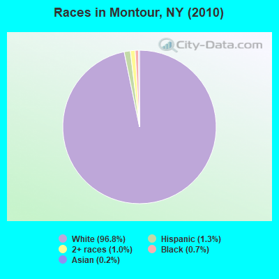
- 2,23396.8%White alone
- 291.3%Hispanic
- 241.0%Two or more races
- 160.7%Black alone
- 50.2%Asian alone
- 10.04%American Indian alone
Races in Montour detailed stats: ancestries, foreign born residents, place of birth
 Recent articles from our blog. Our writers, many of them Ph.D. graduates or candidates, create easy-to-read articles on a wide variety of topics.
Ancestries: English (18.6%), German (18.6%), Irish (14.7%), Italian (10.5%), United States (8.3%), French (5.6%).
Current Local Time: EST time zone
Land area: 18.6 square miles.
Population density: 124 people per square mile (very low).
32 residents are foreign born
| This town: | 1.3% |
| New York: | 20.4% |
| Montour town: | 2.4% ($1,549) |
| New York: | 1.9% ($2,847) |
Nearest city with pop. 50,000+: Union, NY (44.4 miles  , pop. 56,298).
Nearest city with pop. 200,000+: Rochester, NY (69.4 miles , pop. 219,773).
Nearest city with pop. 1,000,000+: Manhattan, NY (183.6 miles , pop. 1,537,195).
Nearest cities:
), ), ), ), ), )Latitude: 42.34 N, Longitude: 76.83 W
Area code commonly used in this area: 607
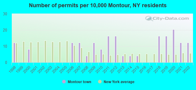
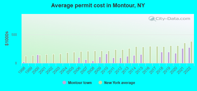
Single-family new house construction building permits:
- 2022: 3 buildings, average cost: $279,200
- 2021: 3 buildings, average cost: $259,200
- 2020: 5 buildings, average cost: $175,000
- 2019: 4 buildings, average cost: $199,900
- 2018: 4 buildings, average cost: $199,900
- 2015: 1 building, cost: $155,000
- 2014: 1 building, cost: $140,000
- 2013: 1 building, cost: $120,600
- 2012: 4 buildings, average cost: $97,500
- 2011: 4 buildings, average cost: $97,500
- 2010: 2 buildings, average cost: $165,000
- 2009: 3 buildings, average cost: $113,700
- 2008: 1 building, cost: $45,200
- 2007: 3 buildings, average cost: $66,300
- 2006: 3 buildings, average cost: $103,300
- 2000: 2 buildings, average cost: $150,000
- 1998: 3 buildings, average cost: $26,400
| Here: | 5.3% |
| New York: | 4.4% |
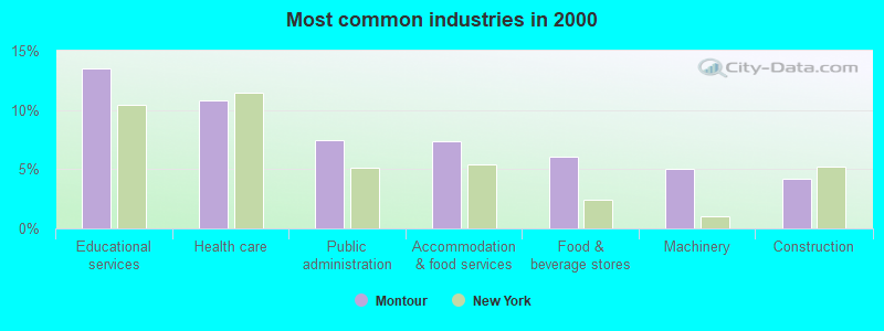
- Educational services (13.6%)
- Health care (10.8%)
- Public administration (7.5%)
- Accommodation & food services (7.3%)
- Food & beverage stores (6.1%)
- Machinery (5.1%)
- Construction (4.2%)
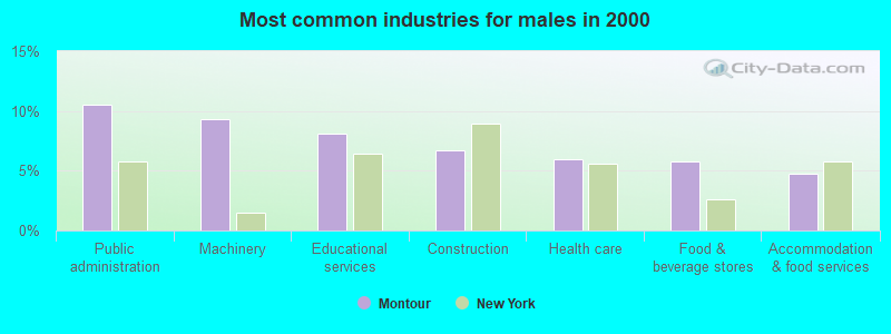
- Public administration (10.5%)
- Machinery (9.3%)
- Educational services (8.1%)
- Construction (6.7%)
- Health care (6.0%)
- Food & beverage stores (5.8%)
- Accommodation & food services (4.7%)
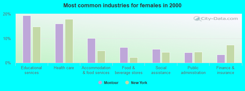
- Educational services (19.4%)
- Health care (16.0%)
- Accommodation & food services (10.1%)
- Food & beverage stores (6.3%)
- Social assistance (5.6%)
- Public administration (4.3%)
- Finance & insurance (3.4%)
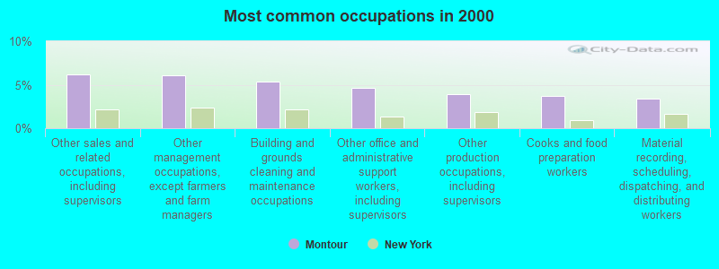
- Other sales and related occupations, including supervisors (6.2%)
- Other management occupations, except farmers and farm managers (6.1%)
- Building and grounds cleaning and maintenance occupations (5.3%)
- Other office and administrative support workers, including supervisors (4.6%)
- Other production occupations, including supervisors (3.9%)
- Cooks and food preparation workers (3.7%)
- Material recording, scheduling, dispatching, and distributing workers (3.4%)
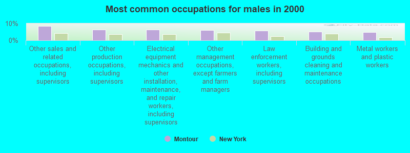
- Other sales and related occupations, including supervisors (8.4%)
- Other production occupations, including supervisors (6.3%)
- Electrical equipment mechanics and other installation, maintenance, and repair workers, including supervisors (6.3%)
- Other management occupations, except farmers and farm managers (6.1%)
- Law enforcement workers, including supervisors (5.6%)
- Building and grounds cleaning and maintenance occupations (5.1%)
- Metal workers and plastic workers (4.7%)
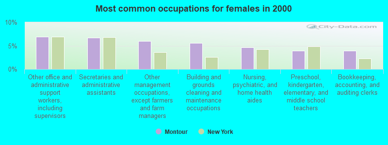
- Other office and administrative support workers, including supervisors (6.9%)
- Secretaries and administrative assistants (6.7%)
- Other management occupations, except farmers and farm managers (6.0%)
- Building and grounds cleaning and maintenance occupations (5.6%)
- Nursing, psychiatric, and home health aides (4.7%)
- Preschool, kindergarten, elementary, and middle school teachers (3.9%)
- Bookkeeping, accounting, and auditing clerks (3.9%)
Average climate in Montour, New York
Based on data reported by over 4,000 weather stations


(lower is better)
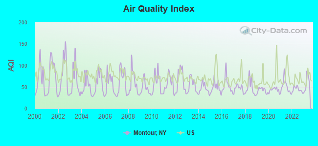
Air Quality Index (AQI) level in 2023 was 59.0. This is better than average.
| City: | 59.0 |
| U.S.: | 72.6 |
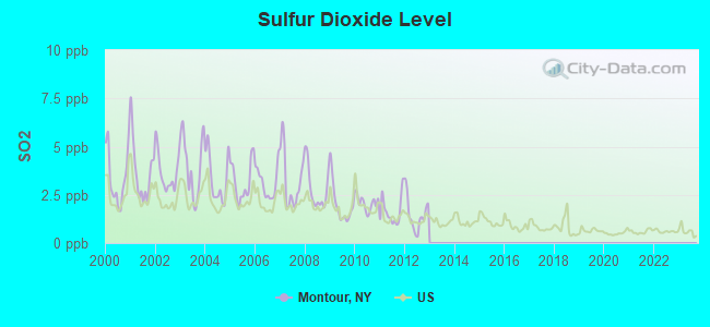
Sulfur Dioxide (SO2) [ppb] level in 2012 was 1.48. This is about average. Closest monitor was 10.1 miles away from the city center.
| City: | 1.48 |
| U.S.: | 1.51 |
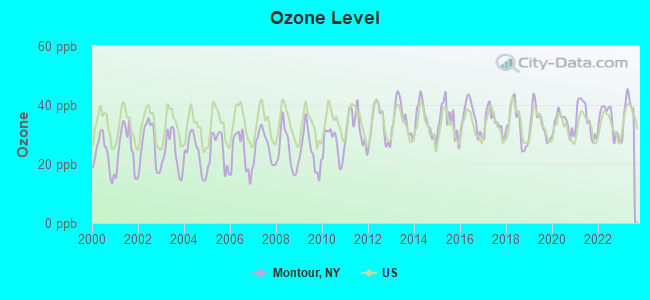
Ozone [ppb] level in 2023 was 38.5. This is about average. Closest monitor was 10.1 miles away from the city center.
| City: | 38.5 |
| U.S.: | 33.3 |
Tornado activity:
Montour-area historical tornado activity is near New York state average. It is 65% smaller than the overall U.S. average.
On 8/30/1955, a category F3 (max. wind speeds 158-206 mph) tornado 4.4 miles away from the Montour town center caused between $5000 and $50,000 in damages.
On 5/2/1983, a category F3 tornado 22.9 miles away from the town center injured 6 people and caused between $500,000 and $5,000,000 in damages.
Earthquake activity:
Montour-area historical earthquake activity is significantly above New York state average. It is 66% smaller than the overall U.S. average.On 10/7/1983 at 10:18:46, a magnitude 5.3 (5.1 MB, 5.3 LG, 5.1 ML, Class: Moderate, Intensity: VI - VII) earthquake occurred 168.1 miles away from the city center
On 9/25/1998 at 19:52:52, a magnitude 5.2 (4.8 MB, 4.3 MS, 5.2 LG, 4.5 MW, Depth: 3.1 mi) earthquake occurred 192.5 miles away from Montour center
On 8/23/2011 at 17:51:04, a magnitude 5.8 (5.8 MW, Depth: 3.7 mi) earthquake occurred 311.9 miles away from Montour center
On 4/20/2002 at 10:50:47, a magnitude 5.3 (5.3 ML, Depth: 3.0 mi) earthquake occurred 217.7 miles away from the city center
On 4/20/2002 at 10:50:47, a magnitude 5.2 (5.2 MB, 4.2 MS, 5.2 MW, 5.0 MW) earthquake occurred 215.8 miles away from Montour center
On 1/16/1994 at 01:49:16, a magnitude 4.6 (4.6 MB, 4.6 LG, Depth: 3.1 mi, Class: Light, Intensity: IV - V) earthquake occurred 145.1 miles away from the city center
Magnitude types: regional Lg-wave magnitude (LG), body-wave magnitude (MB), local magnitude (ML), surface-wave magnitude (MS), moment magnitude (MW)
Natural disasters:
The number of natural disasters in Schuyler County (12) is smaller than the US average (15).Major Disasters (Presidential) Declared: 6
Emergencies Declared: 5
Causes of natural disasters: Floods: 5, Storms: 4, Hurricanes: 2, Blizzard: 1, Heavy Rain: 1, Power Outage: 1, Tornado: 1, Tropical Storm: 1, Other: 2 (Note: some incidents may be assigned to more than one category).
Hospitals and medical centers near Montour:
- SCHUYLER COUNTY CHAPTER NYS ARC (Hospital, about 1 miles away; MONTOUR FALLS, NY)
- ARNOT HEALTH SCHUYLER DIALYSIS (Dialysis Facility, about 2 miles away; MONTOUR FALLS, NY)
- SCHUYLER HOSPITAL, INC Critical Access Hospitals (about 2 miles away; MONTOUR FALLS, NY)
- SCHUYLER HOSPITAL INC AND LONG TERM CARE UNIT S N F (Nursing Home, about 2 miles away; MONTOUR FALLS, NY)
- SCHUYLER COUNTY CHHA (Home Health Center, about 3 miles away; WATKINS GLEN, NY)
- BETHANY NURSING HOME (Nursing Home, about 11 miles away; HORSEHEADS, NY)
- UCPA OF CHEMUNG COUNTY (Hospital, about 11 miles away; HORSEHEADS, NY)
Colleges/universities with over 2000 students nearest to Montour:
- Ithaca College (about 19 miles; Ithaca, NY; Full-time enrollment: 6,781)
- Cornell University (about 20 miles; Ithaca, NY; FT enrollment: 20,360)
- Corning Community College (about 20 miles; Corning, NY; FT enrollment: 3,036)
- Tompkins Cortland Community College (about 31 miles; Dryden, NY; FT enrollment: 3,884)
- Hobart William Smith Colleges (about 37 miles; Geneva, NY; FT enrollment: 2,476)
- SUNY College at Cortland (about 37 miles; Cortland, NY; FT enrollment: 6,838)
- Mansfield University of Pennsylvania (about 40 miles; Mansfield, PA; FT enrollment: 2,826)
Points of interest:
Notable locations in Montour: Montour Falls Village Sewage Treatment Plant (A), Montour Falls Marina (B), Montour Falls Memorial Library (C), The Falls Home for Adults (D), Montour Falls Memorial Library (E), Montour Falls Fire Department (F). Display/hide their locations on the map
Churches in Montour include: Montour Falls United Methodist Church (A), Mount Calvary Lutheran Church (B), First Baptist Church (C), Bethel Fellowship Church (D). Display/hide their locations on the map
Cemeteries: Highland Cemetery (1), Cook Cemetery (2), Coe Cemetery (3). Display/hide their locations on the map
Creeks: Catharine Creek (A), Shequaga Creek (B), Johns Creek (C), Catlin Mill Creek (D). Display/hide their locations on the map
| This town: | 2.2 people |
| New York: | 2.6 people |
| This town: | 56.8% |
| Whole state: | 63.5% |
| This town: | 9.0% |
| Whole state: | 6.8% |
Likely homosexual households (counted as self-reported same-sex unmarried-partner households)
- Lesbian couples: 0.3% of all households
- Gay men: 0.1% of all households
| This town: | 11.7% |
| Whole state: | 14.6% |
| This town: | 5.1% |
| Whole state: | 7.4% |
People in group quarters in Montour in 2010:
- 25 people in college/university student housing
- 17 people in residential treatment centers for adults
- 7 people in group homes intended for adults
24 people in homes for the mentally retarded in 2000
For population 15 years and over in Montour:
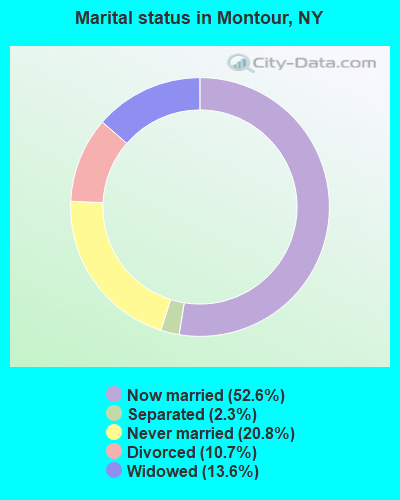
- Never married: 20.8%
- Now married: 52.6%
- Separated: 2.3%
- Widowed: 13.6%
- Divorced: 10.7%
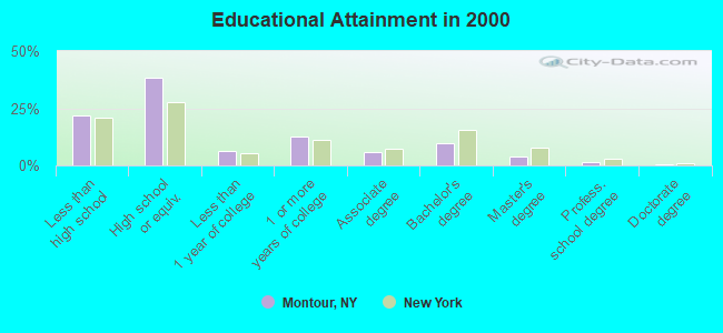
For population 25 years and over in Montour:
- High school or higher: 78.0%
- Bachelor's degree or higher: 15.1%
- Graduate or professional degree: 5.6%
- Unemployed: 4.7%
- Mean travel time to work (commute): 21.9 minutes
| Here: | 11.6 |
| New York average: | 14.2 |
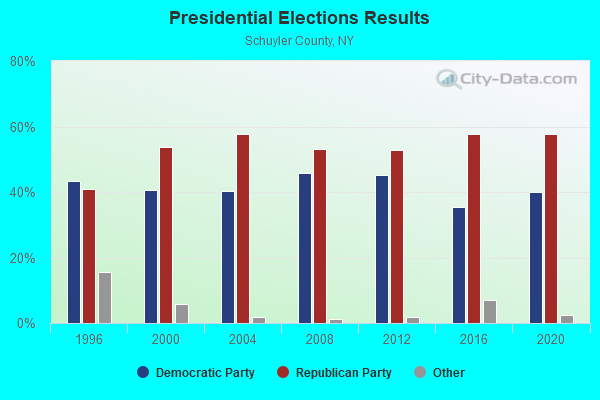
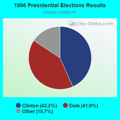
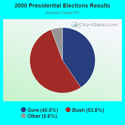

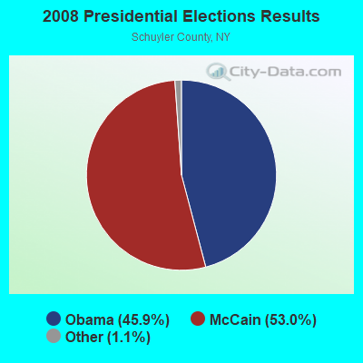
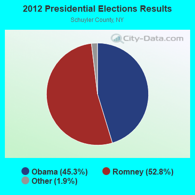

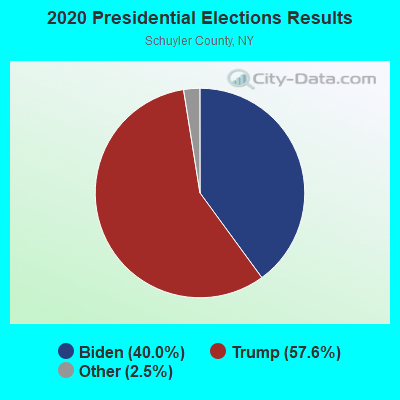
Graphs represent county-level data. Detailed 2008 Election Results
Religion statistics for Montour, NY (based on Schuyler County data)
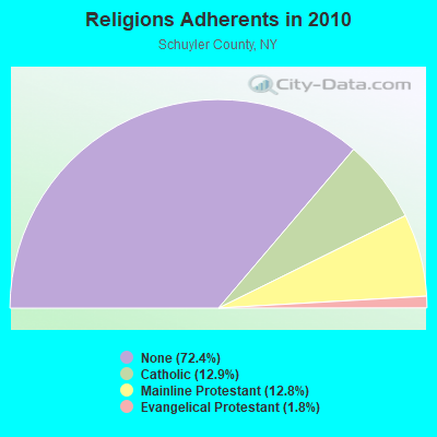
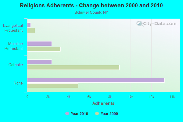
| Religion | Adherents | Congregations |
|---|---|---|
| Catholic | 2,359 | 2 |
| Mainline Protestant | 2,354 | 22 |
| Evangelical Protestant | 329 | 8 |
| Other | 15 | 3 |
| None | 13,286 | - |
Food Environment Statistics:
| Schuyler County: | 1.05 / 10,000 pop. |
| State: | 4.13 / 10,000 pop. |
| This county: | 0.53 / 10,000 pop. |
| New York: | 0.06 / 10,000 pop. |
| Schuyler County: | 1.05 / 10,000 pop. |
| State: | 0.92 / 10,000 pop. |
| Schuyler County: | 3.69 / 10,000 pop. |
| New York: | 1.68 / 10,000 pop. |
| Here: | 12.12 / 10,000 pop. |
| New York: | 8.82 / 10,000 pop. |
| This county: | 8.1% |
| State: | 8.2% |
| This county: | 24.3% |
| New York: | 23.8% |
| Schuyler County: | 17.5% |
| State: | 15.6% |
Strongest AM radio stations in Montour:
- WGMF (1490 AM; 0 kW; WATKINS GLEN, NY; Owner: CHEMUNG COUNTY RADIO, INC.)
- WLNL (1000 AM; daytime; 5 kW; HORSEHEADS, NY; Owner: LIGHTHOUSE MEDIA, INC.)
- WWLZ (820 AM; 4 kW; HORSEHEADS, NY; Owner: CHEMUNG COUNTY RADIO, INC.)
- WPIE (1160 AM; 5 kW; TRUMANSBURG, NY; Owner: PEMBROOK PINES ITHACA LTD. N.A.)
- WEHH (1590 AM; 5 kW; ELMIRA HTS/HORSEHEAD, NY; Owner: PEMBROOK PINES ELMIRA, LTD.)
- WELM (1410 AM; 5 kW; ELMIRA, NY; Owner: PEMBROOK PINES ELMIRA, LIMITED)
- WABH (1380 AM; 10 kW; BATH, NY)
- WFLR (1570 AM; 5 kW; DUNDEE, NY; Owner: LAKES COUNTY COMMUNICATION CORP.)
- WTKO (1470 AM; 5 kW; ITHACA, NY; Owner: EAGLE II BROADCASTING CORPORATION)
- WHAM (1180 AM; 50 kW; ROCHESTER, NY; Owner: CITICASTERS LICENSES, L.P.)
- WHCU (870 AM; 5 kW; ITHACA, NY; Owner: EAGLE BROADCASTING COMPANY, INC.)
- WATS (960 AM; 5 kW; SAYRE, PA; Owner: WATS BROADCASTING, INC.)
- WEBO (1330 AM; 5 kW; OWEGO, NY; Owner: TIOGA MEDIA, INC.)
Strongest FM radio stations in Montour:
- WQNY (103.7 FM; ITHACA, NY; Owner: EAGLE II BROADCASTING CORPORATION)
- WNGZ (104.9 FM; MONTOUR FALLS, NY; Owner: CHEMUNG COUNTY RADIO, INC.)
- WOKN (99.5 FM; SOUTHPORT, NY; Owner: PEMBROOK PINES ELMIRA, LTD.)
- WLVY (94.3 FM; ELMIRA, NY; Owner: PEMBROOK PINES ELMIRA, LTD.)
- WCBA-FM (98.7 FM; CORNING, NY; Owner: EOLIN BROADCASTING, INC.)
- WSQE (91.1 FM; CORNING, NY; Owner: WSKG PUB. TELECOMMUNICATIONS COUNCIL)
- W205BR (88.9 FM; ELMIRA, NY; Owner: PENSACOLA CHRISTIAN COLLEGE, INC.)
- WGMM (97.7 FM; BIG FLATS, NY; Owner: EOLIN BROADCASTING, INC.)
- WFLR-FM (95.9 FM; DUNDEE, NY; Owner: LAKES COUNTRY COMMUNICATIONS CORP.)
- WNKI (106.1 FM; CORNING, NY; Owner: CHEMUNG COUNTY RADIO, INC.)
- WENY-FM (92.7 FM; ELMIRA, NY; Owner: EOLIN BROADCASTING, INC.)
- WYXL (97.3 FM; ITHACA, NY; Owner: EAGLE BROADCASTING COMPANY)
- WPGI (100.9 FM; HORSEHEADS, NY; Owner: CHEMUNG COUNTY RADIO, INC.)
- W215AB (90.9 FM; WATKINS GLEN, NY; Owner: WSKG PUBLIC TELECOMMUNICATIONS COUNCIL)
- WMTT (94.7 FM; TIOGA, PA; Owner: EUROPA COMMUNICATIONS, INC.)
- WPHR (106.9 FM; AUBURN, NY; Owner: CLEAR CHANNEL BROADCASTING LICENSES, INC.)
- WCIY (88.9 FM; CANANDAIGUA, NY; Owner: FAMILY LIFE MINISTRIES, INC.)
- WHWK (98.1 FM; BINGHAMTON, NY; Owner: CITADEL BROADCASTING COMPANY)
- W201CO (88.1 FM; ELMIRA, NY; Owner: FAMILY LIFE MINISTRIES, INC.)
- WFXF (107.3 FM; SOUTH BRISTOL TOWNSH, NY; Owner: CITICASTERS LICENSES, L.P.)
TV broadcast stations around Montour:
- WETM-TV (Channel 18; ELMIRA, NY; Owner: SMITH TELEVISION OF NEW YORK LICENSE HOLDINGS, INC.)
- WENY-TV (Channel 36; ELMIRA, NY; Owner: LILLY BROADCASTING, L.L.C.)
- W59DG (Channel 59; ELMIRA, NY; Owner: TRINITY BROADCASTING NETWORK)
- W21BW (Channel 21; ELMIRA, NY; Owner: THREE ANGELS BROADCASTING NETWORK INC.)
- WYDC (Channel 48; CORNING, NY; Owner: WYDC, INC.)
- W26BF (Channel 26; ELMIRA, NY; Owner: WYDC, INC.)
- W60AD (Channel 60; SAVONA, NY; Owner: WSKG PUBLIC TELECOMMUNICATIONS COUNCIL)
- W16AX (Channel 16; ITHACA, NY; Owner: WSYT LICENSEE L.P.)
- W20BL (Channel 20; BATH, NY; Owner: WYDC, INC.)
- National Bridge Inventory (NBI) Statistics
- 7Number of bridges
- 59ft / 18.3mTotal length
- $9,629,000Total costs
- 9,730Total average daily traffic
- 989Total average daily truck traffic
- 10,214Total future (year 2038) average daily traffic
FCC Registered Antenna Towers:
6- David Zylka, 4715 Stuart Rd (Lat: 42.301389 Lon: -76.800556), Type: 30.4, Overall height: 27.4 m, Registrant: Crown Atlantic Company, LLC, Canon-sburg, Phone: (724) 416-2000
- Kathryn M Wheeler, 4715 Stuart Rd (Lat: 42.302083 Lon: -76.799722), Type: 31.1, Overall height: 27.4 m, Registrant: Upstate Cellular Network, Roche-ster, Phone: (716) 321-7000
- Kathryn M Wheeler, 4715 Stuart Rd (Lat: 42.302083 Lon: -76.799722), Type: 31.1, Overall height: 27.4 m, Registrant: Upstate Cellular Network, Roche-ster, Phone: (716) 321-7000
- Holly E Groschner, 4715 Stuart Rd (Lat: 42.302083 Lon: -76.799722), Type: 31.1, Overall height: 27.4 m, Registrant: Crown Atlantic Company, LLC, Canon-sburg, Phone: (724) 416-2000
- CHRISTINE A VERRE, 4715 Stuart Rd (Lat: 42.302083 Lon: -76.799722), Type: 31.1, Overall height: 27.4 m, Registrant: Crown Atlantic Company, LLC, Monica.Gambino@crowncastle.Com, , Canon-sburg, Phone: (724) 416-2516
- 4715 Stuart Rd (Lat: 42.301389 Lon: -76.800556), Type: 30.4, Overall height: 27.4 m, Registrant: Ithaca Wireline Cellular Limited Partnership, Pitts-ford, Phone: (716) 777-0202
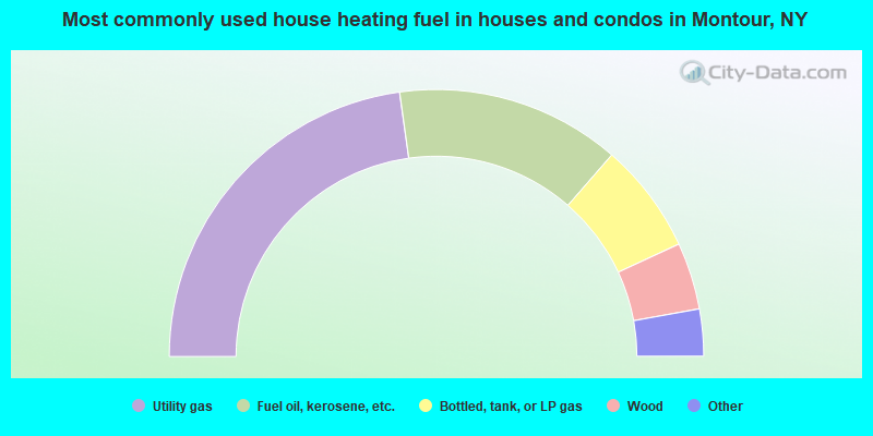
- 45.6%Utility gas
- 27.2%Fuel oil, kerosene, etc.
- 13.4%Bottled, tank, or LP gas
- 8.1%Wood
- 3.3%Electricity
- 2.4%Coal or coke

- 52.6%Utility gas
- 33.7%Electricity
- 7.7%Bottled, tank, or LP gas
- 3.5%Fuel oil, kerosene, etc.
- 1.0%Wood
- 1.0%Other fuel
- 0.6%No fuel used
Montour compared to New York state average:
- Median house value significantly below state average.
- Unemployed percentage significantly below state average.
- Black race population percentage significantly below state average.
- Hispanic race population percentage significantly below state average.
- Median age above state average.
- Foreign-born population percentage significantly below state average.
- Length of stay since moving in significantly above state average.
- Number of rooms per house significantly below state average.
- House age significantly below state average.
- Institutionalized population percentage above state average.
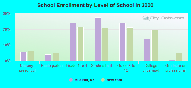
- Number of college students below state average.
- Percentage of population with a bachelor's degree or higher below state average.