Mattawamkeag, Maine
Submit your own pictures of this town and show them to the world
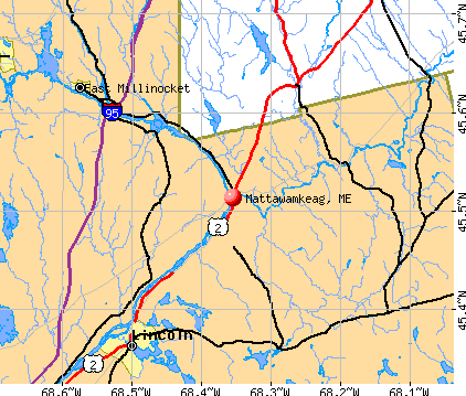
- OSM Map
- General Map
- Google Map
- MSN Map
Population change since 2000: -16.7%
 |
| Males: 350 | |
| Females: 337 |
| Median resident age: | 50.4 years |
| Maine median age: | 43.0 years |
Zip codes: 04459.
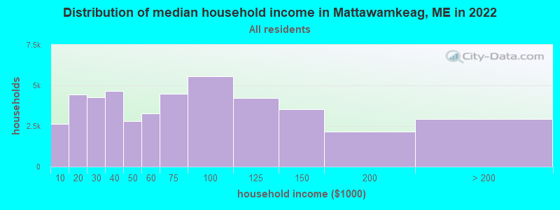
| Mattawamkeag: | $41,744 |
| ME: | $69,543 |
Estimated per capita income in 2022: $25,275 (it was $12,573 in 2000)
Mattawamkeag town income, earnings, and wages data
Estimated median house or condo value in 2022: $125,420 (it was $48,200 in 2000)
| Mattawamkeag: | $125,420 |
| ME: | $290,600 |
Mean prices in 2022: all housing units: $235,563; detached houses: $252,705; townhouses or other attached units: $267,749; in 2-unit structures: $255,332; in 3-to-4-unit structures: $815,300; in 5-or-more-unit structures: $185,873; mobile homes: $93,017; occupied boats, rvs, vans, etc.: $21,333
Detailed information about poverty and poor residents in Mattawamkeag, ME
Compare current foreclosures near Mattawamkeag, ME:
| Photo | Address | Area | Beds / Baths | Price | Details |
|---|---|---|---|---|---|

|
#1
Tar Ridge Rd
Springfield, ME 04487
|
1,120 sq. feet
|
1 baths 2 beds |
$175,000
|
show details |

|
#2
Main St
Mattawamkeag, ME 04459
|
- sq. feet
|
- baths - beds |
show details | |

|
#3
Cedar St
East Millinocket, ME 04430
|
- sq. feet
|
1 baths 3 beds |
$140,000
|
show details |

|
#4
Smart Estates Dr
Lee, ME 04455
|
1,170 sq. feet
|
1 baths 2 beds |
show details | |

|
#5
Pea Ridge Rd
Lincoln, ME 04457
|
- sq. feet
|
- baths - beds |
show details | |

|
#6
Town Farm Rd
Lincoln, ME 04457
|
- sq. feet
|
- baths - beds |
show details | |

|
#7
Warsaw Cir
Lincoln, ME 04457
|
- sq. feet
|
- baths - beds |
show details | |

|
#8
Libby St
Lincoln, ME 04457
|
- sq. feet
|
- baths - beds |
show details | |

|
#9
Mackenzie Ave
Lincoln, ME 04457
|
- sq. feet
|
- baths - beds |
show details | |

|
#10
Wilson St
Lincoln, ME 04457
|
- sq. feet
|
- baths - beds |
show details |
| Photo | Address | Area | Beds / Baths | Price | Details |
|---|---|---|---|---|---|

|
#11
Edwards St
Lincoln, ME 04457
|
- sq. feet
|
- baths - beds |
show details | |

|
#12
Pinkham St
Lincoln, ME 04457
|
- sq. feet
|
- baths - beds |
show details | |

|
#13
Cooks Cor
Lincoln, ME 04457
|
- sq. feet
|
- baths - beds |
show details | |

|
Check over 1 million property listings on Foreclosure.com!
|
browse all offers | |||

- 67097.5%White alone
- 60.9%American Indian alone
- 50.7%Two or more races
- 40.6%Hispanic
- 10.1%Black alone
- 10.1%Asian alone
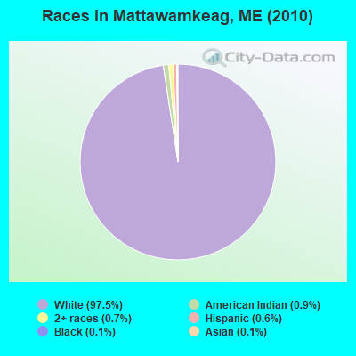
Races in Mattawamkeag detailed stats: ancestries, foreign born residents, place of birth
According to our research of Maine and other state lists, there were 2 registered sex offenders living in Mattawamkeag, Maine as of June 05, 2024.
The ratio of all residents to sex offenders in Mattawamkeag is 344 to 1.
 Recent articles from our blog. Our writers, many of them Ph.D. graduates or candidates, create easy-to-read articles on a wide variety of topics.

 | If Oil Boiler Goes - Replace it or Choose Something Else? (66 replies) |
| Spring Flooding (4 replies) |
| Maine weather thread (3207 replies) |
| ATV Heaven (11 replies) |
| Rivers Rising (14 replies) |
| Bangor Daily News Article About The Allagash. (9 replies) |
Latest news from Mattawamkeag, ME collected exclusively by city-data.com from local newspapers, TV, and radio stations
Ancestries: English (23.2%), French (15.5%), United States (12.8%), Irish (11.2%), French Canadian (4.5%), Italian (2.7%).
Current Local Time: EST time zone
Incorporated on 02/14/1860
Elevation: 217 feet
Land area: 37.4 square miles.
Population density: 18 people per square mile (very low).
11 residents are foreign born
| This town: | 1.3% |
| Maine: | 2.9% |
| Mattawamkeag town: | 1.3% ($623) |
| Maine: | 1.5% ($1,417) |
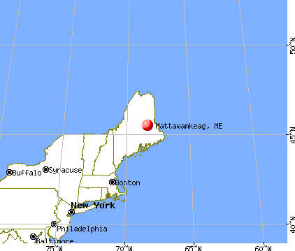
Nearest city with pop. 50,000+: Portland, ME  (160.1 miles , pop. 64,249).
Nearest city with pop. 200,000+: Boston, MA (260.6 miles , pop. 589,141).
Nearest city with pop. 1,000,000+: Bronx, NY (427.4 miles , pop. 1,332,650).
Nearest cities:
), ), ), ), )Latitude: 45.52 N, Longitude: 68.32 W
Area code: 207

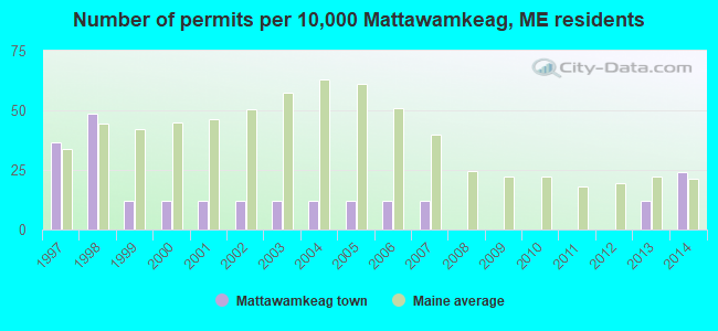
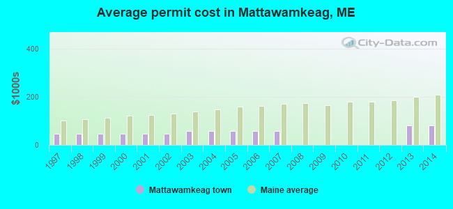
Single-family new house construction building permits:
- 2014: 2 buildings, average cost: $80,000
- 2013: 1 building, cost: $80,000
- 2007: 1 building, cost: $58,000
- 2006: 1 building, cost: $58,000
- 2005: 1 building, cost: $58,000
- 2004: 1 building, cost: $58,000
- 2003: 1 building, cost: $58,000
- 2002: 1 building, cost: $45,000
- 2001: 1 building, cost: $45,000
- 2000: 1 building, cost: $45,000
- 1999: 1 building, cost: $45,000
- 1998: 4 buildings, average cost: $46,000
- 1997: 3 buildings, average cost: $46,000
| Here: | 6.3% |
| Maine: | 3.4% |


- Health care (14.6%)
- Paper (14.3%)
- Agriculture, forestry, fishing & hunting (8.8%)
- Educational services (8.1%)
- Wood products (6.8%)
- Food & beverage stores (6.2%)
- Public administration (5.5%)

- Paper (24.4%)
- Agriculture, forestry, fishing & hunting (14.0%)
- Wood products (11.6%)
- Truck transportation (9.8%)
- Public administration (6.1%)
- Construction (4.3%)
- Religious, grantmaking, civic, professional, similar organizations (4.3%)

- Health care (26.4%)
- Educational services (16.0%)
- Food & beverage stores (10.4%)
- Accommodation & food services (8.3%)
- Public administration (4.9%)
- Administrative & support & waste management services (4.2%)
- Agriculture, forestry, fishing & hunting (2.8%)

- Other production occupations, including supervisors (8.8%)
- Driver/sales workers and truck drivers (8.1%)
- Secretaries and administrative assistants (6.5%)
- Nursing, psychiatric, and home health aides (5.2%)
- Fishing, hunting, and forestry occupations (5.2%)
- Other office and administrative support workers, including supervisors (4.2%)
- Cooks and food preparation workers (3.6%)
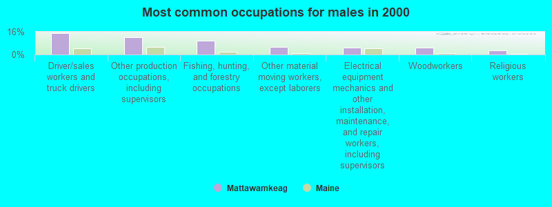
- Driver/sales workers and truck drivers (15.2%)
- Other production occupations, including supervisors (12.2%)
- Fishing, hunting, and forestry occupations (9.8%)
- Other material moving workers, except laborers (5.5%)
- Electrical equipment mechanics and other installation, maintenance, and repair workers, including supervisors (4.9%)
- Woodworkers (4.9%)
- Religious workers (3.0%)

- Secretaries and administrative assistants (13.9%)
- Nursing, psychiatric, and home health aides (11.1%)
- Other office and administrative support workers, including supervisors (9.0%)
- Cooks and food preparation workers (5.6%)
- Other production occupations, including supervisors (4.9%)
- Information and record clerks, except customer service representatives (4.2%)
- Cashiers (4.2%)
Average climate in Mattawamkeag, Maine
Based on data reported by over 4,000 weather stations


Earthquake activity:
Mattawamkeag-area historical earthquake activity is significantly above Maine state average. It is 83% smaller than the overall U.S. average.On 4/20/2002 at 10:50:47, a magnitude 5.3 (5.3 ML, Depth: 3.0 mi, Class: Moderate, Intensity: VI - VII) earthquake occurred 272.1 miles away from the city center
On 10/16/2012 at 23:12:25, a magnitude 4.7 (4.7 ML, Depth: 10.0 mi, Class: Light, Intensity: IV - V) earthquake occurred 175.8 miles away from the city center
On 4/20/2002 at 10:50:47, a magnitude 5.2 (5.2 MB, 4.2 MS, 5.2 MW, 5.0 MW) earthquake occurred 273.5 miles away from Mattawamkeag center
On 10/7/1983 at 10:18:46, a magnitude 5.3 (5.1 MB, 5.3 LG, 5.1 ML) earthquake occurred 315.1 miles away from the city center
On 1/19/1982 at 00:14:42, a magnitude 4.7 (4.5 MB, 4.7 MD, 4.5 LG) earthquake occurred 213.7 miles away from Mattawamkeag center
On 9/16/1994 at 04:22:42, a magnitude 3.6 (3.6 LG, Depth: 3.1 mi, Class: Light, Intensity: II - III) earthquake occurred 15.3 miles away from the city center
Magnitude types: regional Lg-wave magnitude (LG), body-wave magnitude (MB), duration magnitude (MD), local magnitude (ML), surface-wave magnitude (MS), moment magnitude (MW)
Natural disasters:
The number of natural disasters in Penobscot County (19) is greater than the US average (15).Major Disasters (Presidential) Declared: 11
Emergencies Declared: 7
Causes of natural disasters: Floods: 9, Storms: 8, Snows: 5, Heavy Rains: 2, Blizzard: 1, Hurricane: 1, Ice Storm: 1, Snowfall: 1, Wind: 1, Winter Storm: 1, Other: 2 (Note: some incidents may be assigned to more than one category).
Colleges/universities with over 2000 students nearest to Mattawamkeag:
- University of Maine (about 47 miles; Orono, ME; Full-time enrollment: 8,931)
- Husson University (about 53 miles; Bangor, ME; FT enrollment: 2,421)
- University of Maine at Farmington (about 107 miles; Farmington, ME; FT enrollment: 2,036)
- University of Maine at Augusta (about 110 miles; Augusta, ME; FT enrollment: 3,204)
- Saint Joseph's College of Maine (about 159 miles; Standish, ME; FT enrollment: 2,010)
- Southern Maine Community College (about 160 miles; South Portland, ME; FT enrollment: 4,666)
- University of Southern Maine (about 161 miles; Portland, ME; FT enrollment: 6,647)
Points of interest:
Notable locations in Mattawamkeag: Mattawamkeag Public Library (A), Mattawamkeag Fire and Rescue (B). Display/hide their locations on the map
Churches in Mattawamkeag include: Church of God (A), Mattawamkeag Bible Baptist Church (B). Display/hide their locations on the map
Lake: Back Settlement Pond (A). Display/hide its location on the map
Streams, rivers, and creeks: Gordon Brook (A), Whitten Brook (B), Mattawamkeag River (C), Carlisle Brook (D), Bog Brook (E). Display/hide their locations on the map
Park in Mattawamkeag: Mattawamkeag Wilderness County Park (1). Display/hide its location on the map
Hotel: Cross-Roads Restaurant & Motel (270 Main Street) (1). Display/hide its approximate location on the map
Drinking water stations with addresses in Mattawamkeag and their reported violations in the past:
CROSSROADS RESTAURANT & MOTEL (Population served: 175, Groundwater):Past monitoring violations:MATTAWAMKEAG WILDERNESS PARK (Population served: 145, Groundwater):
- 9 routine major monitoring violations
- 5 regular monitoring violations
Past monitoring violations:
- 2 routine major monitoring violations
- One regular monitoring violation
| This town: | 2.2 people |
| Maine: | 2.3 people |
| This town: | 62.1% |
| Whole state: | 62.9% |
| This town: | 10.1% |
| Whole state: | 9.4% |
No gay or lesbian households reported
| This town: | 12.9% |
| Whole state: | 10.9% |
| This town: | 4.6% |
| Whole state: | 4.1% |
For population 15 years and over in Mattawamkeag:
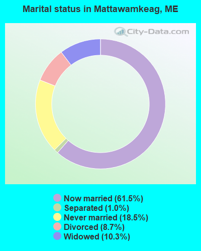
- Never married: 18.5%
- Now married: 61.5%
- Separated: 1.0%
- Widowed: 10.3%
- Divorced: 8.7%
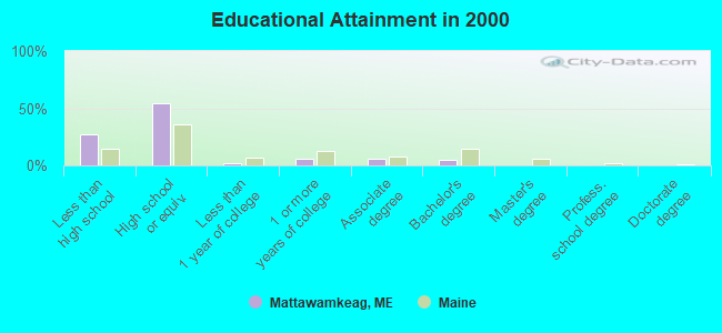
For population 25 years and over in Mattawamkeag:
- High school or higher: 73.3%
- Bachelor's degree or higher: 4.8%
- Graduate or professional degree: 0.3%
- Unemployed: 10.7%
- Mean travel time to work (commute): 28.8 minutes

| Here: | 10.4 |
| Maine average: | 11.2 |


Graphs represent county-level data. Detailed 2008 Election Results
Religion statistics for Mattawamkeag, ME (based on Penobscot County data)


| Religion | Adherents | Congregations |
|---|---|---|
| Catholic | 16,581 | 15 |
| Mainline Protestant | 9,715 | 59 |
| Evangelical Protestant | 7,523 | 80 |
| Other | 2,936 | 22 |
| Orthodox | 300 | 1 |
| None | 116,868 | - |
Food Environment Statistics:
| Penobscot County: | 2.29 / 10,000 pop. |
| Maine: | 2.80 / 10,000 pop. |
| This county: | 0.13 / 10,000 pop. |
| Maine: | 0.14 / 10,000 pop. |
| Here: | 2.56 / 10,000 pop. |
| State: | 2.20 / 10,000 pop. |
| Penobscot County: | 5.72 / 10,000 pop. |
| Maine: | 5.75 / 10,000 pop. |
| Here: | 7.41 / 10,000 pop. |
| Maine: | 11.02 / 10,000 pop. |
| Penobscot County: | 9.0% |
| Maine: | 8.2% |
| This county: | 28.0% |
| Maine: | 25.0% |
Strongest AM radio stations in Mattawamkeag:
- WZON (620 AM; 5 kW; BANGOR, ME; Owner: THE ZONE CORPORATION)
- WABI (910 AM; 5 kW; BANGOR, ME; Owner: CLEAR CHANNEL BROADCASTING LICENSES, INC.)
- WREM (710 AM; daytime; 5 kW; MONTICELLO, ME; Owner: ALLAN H WEINER)
- WSYY (1240 AM; 1 kW; MILLINOCKET, ME; Owner: KATAHDIN BROADCASTING, INC.)
- WSKW (1160 AM; 10 kW; SKOWHEGAN, ME; Owner: MOUNTAIN WIRELESS, INCORPORATED)
- WRKO (680 AM; 50 kW; BOSTON, MA; Owner: ENTERCOM BOSTON LICENSE, LLC)
- WFST (600 AM; 5 kW; CARIBOU, ME; Owner: NORTHERN BROADCAST MINISTRIES, INC.)
- WEEI (850 AM; 50 kW; BOSTON, MA; Owner: ENTERCOM BOSTON LICENSE, LLC)
- WTME (780 AM; 10 kW; RUMFORD, ME; Owner: MOUNTAIN VALLEY BROADCASTING, INC.)
- WBZ (1030 AM; 50 kW; BOSTON, MA; Owner: INFINITY BROADCASTING OPERATIONS, INC.)
- WNNZ (640 AM; 50 kW; WESTFIELD, MA; Owner: CLEAR CHANNEL BROADCASTING LICENSES, INC.)
- WCRN (830 AM; 50 kW; WORCESTER, MA; Owner: CARTER BROADCASTING CORPORATION)
- WCHP (760 AM; 35 kW; CHAMPLAIN, NY; Owner: CHAMPLAIN RADIO, INC.)
Strongest FM radio stations in Mattawamkeag:
- WHCF (88.5 FM; BANGOR, ME; Owner: BANGOR BAPTIST CHURCH)
- WVOM (103.9 FM; HOWLAND, ME; Owner: CLEAR CHANNEL BROADCASTING LICENSES, INC.)
- WHMX (105.7 FM; LINCOLN, ME; Owner: BANGOR BAPTIST CHURCH)
- WSYY-FM (94.9 FM; MILLINOCKET, ME; Owner: KATAHDIN COMMUNICATIONS, INC.)
TV broadcast stations around Mattawamkeag:
- W34CN (Channel 34; MEDWAY, ME; Owner: TRINITY BROADCASTING NETWORK)
Mattawamkeag fatal accident list:
Nov 6, 2007 04:00 AM, Sr-2, Lat: 45.517797, Lon: -68.353839, Vehicles: 1, Persons: 1, Fatalities: 1, Drunk persons involved: 1
Jul 14, 2000 08:50 PM, Sr-157, Vehicles: 1, Persons: 3, Pedestrians: 1, Fatalities: 1
Aug 10, 1984 03:10 PM, 73987399, Vehicles: 2, Persons: 2, Fatalities: 1
Dec 17, 1982 07:30 PM, 73917392, Vehicles: 1, Persons: 3, Fatalities: 1
- National Bridge Inventory (NBI) Statistics
- 3Number of bridges
- 46ft / 14.4mTotal length
- 3,218Total average daily traffic
- 160Total average daily truck traffic
- 4,623Total future (year 2036) average daily traffic
FCC Registered Antenna Towers:
9 (See the full list of FCC Registered Antenna Towers in Mattawamkeag)FCC Registered Broadcast Land Mobile Towers:
5- Municipal Ofc Main St (Lat: 45.516167 Lon: -68.359750), Call Sign: KNDS886,
Assigned Frequencies: 154.310 MHz, Grant Date: 08/31/2002, Expiration Date: 09/16/2012, Cancellation Date: 11/17/2012, Registrant: Federal Licensing Inc, 1588 Fairfield Rd, Gettysburg, PA 17325, Phone: (717) 334-9262, Fax: (717) 334-6440
- Municipal Bldg (Lat: 45.516167 Lon: -68.359750), Call Sign: KNEN298, Licensee ID: L00033752,
Assigned Frequencies: 153.815 MHz, Grant Date: 11/06/1997, Expiration Date: 01/11/2003, Cancellation Date: 04/13/2003, Registrant: Mattawamkeag, Town Of, Main St, Mattawamkeag, ME 04459
- School St (Lat: 45.516167 Lon: -68.356972), Call Sign: KXZ50, Licensee ID: L00046646,
Assigned Frequencies: 158.760 MHz, Grant Date: 03/04/2014, Expiration Date: 05/23/2024, Registrant: County Of Penobscot
- Back Settlement Pound (Lat: 45.537556 Lon: -68.318639), Call Sign: KNDW847,
Assigned Frequencies: 161.175 MHz, 161.115 MHz, 161.475 MHz, Grant Date: 12/18/2003, Expiration Date: 12/20/2013, Cancellation Date: 02/22/2014, Registrant: Eastern Maine Railway, 31depot Street, Mattawamkeag, ME 04459, Phone: (207) 736-2373, Fax: (207) 736-2374, Email:
- Cp Rail Sta Yard Operator (Lat: 45.516167 Lon: -68.351694), Call Sign: KZX275, Licensee ID: L00084961,
Assigned Frequencies: 160.620 MHz, 161.115 MHz, 161.175 MHz, Grant Date: 12/17/2003, Expiration Date: 12/20/2013, Cancellation Date: 06/10/2004, Registrant: Canadian Pacific Limited, Main St, Brownville Junction, ME 04415, Phone: (506) 635-2246
FCC Registered Microwave Towers:
1- MATTAWAMKEAG, Route 2 (Lat: 45.541611 Lon: -68.331306), Type: Gtower, Structure height: 76.2 m, Overall height: 77.4 m, Call Sign: WQNT852,
Assigned Frequencies: 6315.84 MHz, Grant Date: 04/20/2021, Expiration Date: 05/23/2031, Certifier: Steven T Campbell, Registrant: Wilkinson Barker Knauer, LLP, 1800 M Street Nw, Suite 800n, Washington, DC 20036, Phone: (202) 383-3420, Fax: (202) 783-5851, Email:
FCC Registered Amateur Radio Licenses:
4- Call Sign: N1MNI, Licensee ID: L00474160, Grant Date: 02/26/2002, Expiration Date: 05/26/2012, Cancellation Date: 05/28/2014, Registrant: Donald G Whitney, Rt 2, Mattawamkeag, ME 04459-0174
- Call Sign: N1MTT, Licensee ID: L00541584, Grant Date: 07/03/2002, Expiration Date: 06/09/2012, Cancellation Date: 06/10/2014, Registrant: Carl E Sweeney, Mattawamkeag, ME 04459
- Call Sign: N1XKX, Grant Date: 05/29/1996, Expiration Date: 05/29/2006, Cancellation Date: 10/30/2001, Registrant: Fayette H Keith, Mattawamkeag, ME 04459
- Call Sign: KC1TZM, Licensee ID: L02741328, Grant Date: 01/18/2024, Expiration Date: 01/18/2034, Certifier: Paul R Painchaud, Registrant: Paul R Painchaud, 148 Main St, Mattawamkeag, ME 04459-3211
FAA Registered Aircraft:
7- Aircraft: SCOTT A MARKIE JUNK YARD DOG (Category: Land, Seats: 2, Weight: Up to 12,499 Pounds), Engine: LYCOMING O-320 (150 HP) (Reciprocating)
N-Number: 118PB, N118PB, N-118PB, Serial Number: 001, Year manufactured: 2014, Airworthiness Date: 07/21/2014, Certificate Issue Date: 05/31/2014
Registrant (Individual): Scott A Markie, 46 Main St, Mattawamkeag, ME 04459 - Aircraft: TAYLORCRAFT DC-65 (Category: Land, Seats: 2, Weight: Up to 12,499 Pounds, Speed: 82 mph), Engine: CONT MOTOR A&C65 SERIES (65 HP) (Reciprocating)
N-Number: 36370, N36370, N-36370, Serial Number: 4107, Year manufactured: 1941, Airworthiness Date: 10/21/1955, Certificate Issue Date: 11/06/2020
Registrant (Individual): Zachary D Monroe, Po Box 94, Mattawamkeag, ME 04459 - Aircraft: PRICE PETER L 180 EAGLE (Category: Amphibian, Seats: 3, Weight: Up to 12,499 Pounds), Engine: LYCOMING O-360-A1D (180 HP) (Reciprocating)
N-Number: 38TK, N38TK, N-38TK, Serial Number: 2005-1, Year manufactured: 2005, Airworthiness Date: 10/19/2005, Certificate Issue Date: 01/06/2015
Registrant (Individual): Bion C Tolman, 167 Hathaway Rd, Mattawamkeag, ME 04459 - Aircraft: CESSNA 172G (Category: Land, Seats: 4, Weight: Up to 12,499 Pounds, Speed: 105 mph), Engine: CONT MOTOR 0-300 SER (145 HP) (Reciprocating)
N-Number: 5770R, N5770R, N-5770R, Serial Number: 17253439, Year manufactured: 1965, Airworthiness Date: 10/01/1965, Certificate Issue Date: 10/11/2019
Registrant (Individual): David T Furge, 119 Back Settlement Rd, Mattawamkeag, ME 04459 - Aircraft: PIPER J3C-65 (Category: Land, Seats: 2, Weight: Up to 12,499 Pounds, Speed: 67 mph), Engine: CONT MOTOR A&C65 SERIES (65 HP) (Reciprocating)
N-Number: 70780, N70780, N-70780, Serial Number: 17799, Year manufactured: 1946, Airworthiness Date: 12/09/1955, Certificate Issue Date: 06/22/2009
Registrant (Individual): Bion C Tolman, 167 Hathaway Rd, Mattawamkeag, ME 04459 - Aircraft: BUCKEYE AVIATION DREAM MACHINE (Category: Land, Seats: 2, Weight: Up to 12,499 Pounds), Engine: 2 Cycle
N-Number: 5532K, N5532K, N-5532K, Serial Number: 4216, Certificate Issue Date: 10/04/2007
Registrant (Individual): Leon G Markie, 32 Main St, Mattawamkeag, ME 04459
Deregistered: Cancel Date: 07/19/2017 - Aircraft: BUCKEYE AVIATION DREAM MACHINE (Category: Land, Seats: 2, Weight: Up to 12,499 Pounds), Engine: 2 Cycle
N-Number: 5569T, N5569T, N-5569T, Serial Number: 3144, Certificate Issue Date: 10/22/2007
Registrant (Individual): David W Markie, 10 Main St, Mattawamkeag, ME 04459
Deregistered: Cancel Date: 07/18/2017
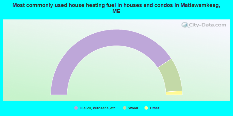
- 81.5%Fuel oil, kerosene, etc.
- 16.7%Wood
- 1.1%Electricity
- 0.7%Bottled, tank, or LP gas
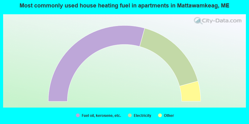
- 58.6%Fuel oil, kerosene, etc.
- 32.9%Electricity
- 2.9%Utility gas
- 2.9%Wood
- 2.9%Other fuel
Mattawamkeag compared to Maine state average:
- Median household income below state average.
- Median house value significantly below state average.
- Black race population percentage significantly below state average.
- Hispanic race population percentage significantly below state average.
- Median age above state average.
- Foreign-born population percentage significantly below state average.
- Renting percentage below state average.
- Length of stay since moving in significantly above state average.
- Number of rooms per house significantly below state average.
- House age significantly below state average.
- Number of college students significantly below state average.
- Percentage of population with a bachelor's degree or higher significantly below state average.