Marbletown, New York
Submit your own pictures of this town and show them to the world
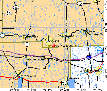
- OSM Map
- General Map
- Google Map
- MSN Map
Population change since 2000: -4.2%
 |
| Males: 2,767 | |
| Females: 2,840 |
| Median resident age: | 47.7 years |
| New York median age: | 40.7 years |
Zip codes: 12484.
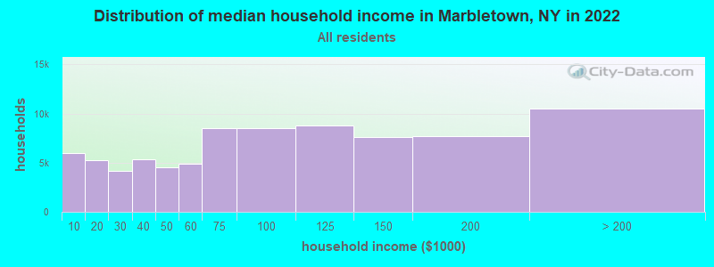
| Marbletown: | $87,359 |
| NY: | $79,557 |
Estimated per capita income in 2022: $52,792 (it was $23,962 in 2000)
Marbletown town income, earnings, and wages data
Estimated median house or condo value in 2022: $422,962 (it was $139,900 in 2000)
| Marbletown: | $422,962 |
| NY: | $400,400 |
Mean prices in 2022: all housing units: $379,181; detached houses: $393,684; townhouses or other attached units: $652,719; in 2-unit structures: $266,147; in 3-to-4-unit structures: $293,759; in 5-or-more-unit structures: $291,039; mobile homes: $115,808
Detailed information about poverty and poor residents in Marbletown, NY


- 5,19692.7%White alone
- 1552.8%Hispanic
- 841.5%Two or more races
- 811.4%Black alone
- 681.2%Asian alone
- 110.2%American Indian alone
- 110.2%Other race alone
- 10.02%Native Hawaiian and Other
Pacific Islander alone
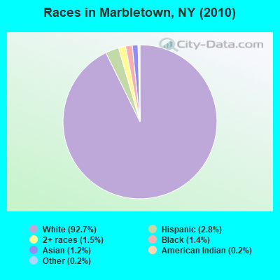
Races in Marbletown detailed stats: ancestries, foreign born residents, place of birth
 Recent articles from our blog. Our writers, many of them Ph.D. graduates or candidates, create easy-to-read articles on a wide variety of topics.


Latest news from Marbletown, NY collected exclusively by city-data.com from local newspapers, TV, and radio stations
Ancestries: German (25.7%), Irish (20.0%), Italian (18.6%), English (15.3%), Dutch (7.9%), Polish (3.9%).
Current Local Time: EST time zone
Land area: 54.6 square miles.
Population density: 103 people per square mile (very low).
169 residents are foreign born (2.4% Europe).
| This town: | 2.9% |
| New York: | 20.4% |
| Marbletown town: | 2.3% ($3,211) |
| New York: | 1.9% ($2,847) |
Nearest city with pop. 50,000+: Danbury, CT  (47.5 miles , pop. 74,848).
Nearest city with pop. 200,000+: Bronx, NY (71.1 miles , pop. 1,332,650).
Nearest cities:
), ), Latitude: 41.85 N, Longitude: 74.16 W
Area code commonly used in this area: 845

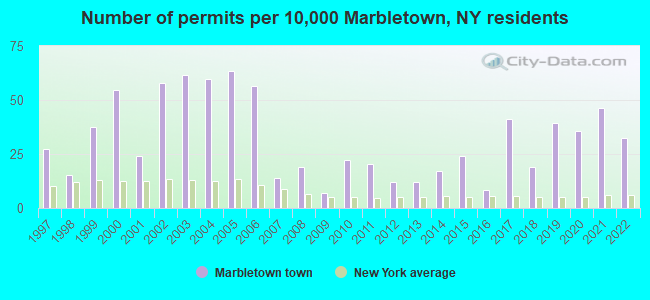
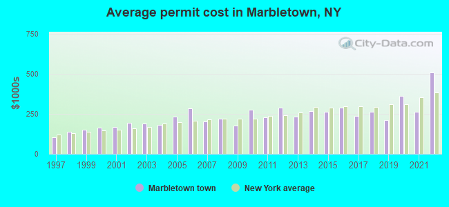
Single-family new house construction building permits:
- 2022: 19 buildings, average cost: $509,900
- 2021: 27 buildings, average cost: $262,500
- 2020: 21 buildings, average cost: $360,900
- 2019: 23 buildings, average cost: $212,300
- 2018: 11 buildings, average cost: $262,200
- 2017: 24 buildings, average cost: $237,400
- 2016: 5 buildings, average cost: $288,000
- 2015: 14 buildings, average cost: $263,100
- 2014: 10 buildings, average cost: $266,900
- 2013: 7 buildings, average cost: $231,900
- 2012: 7 buildings, average cost: $287,600
- 2011: 12 buildings, average cost: $229,800
- 2010: 13 buildings, average cost: $274,700
- 2009: 4 buildings, average cost: $177,500
- 2008: 11 buildings, average cost: $218,300
- 2007: 8 buildings, average cost: $204,000
- 2006: 33 buildings, average cost: $285,400
- 2005: 37 buildings, average cost: $234,300
- 2004: 35 buildings, average cost: $183,400
- 2003: 36 buildings, average cost: $187,500
- 2002: 34 buildings, average cost: $196,300
- 2001: 14 buildings, average cost: $169,500
- 2000: 32 buildings, average cost: $161,600
- 1999: 22 buildings, average cost: $153,200
- 1998: 9 buildings, average cost: $137,000
- 1997: 16 buildings, average cost: $101,600
| Here: | 3.9% |
| New York: | 4.4% |
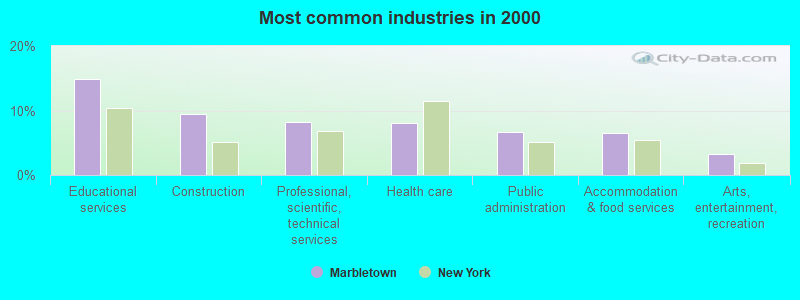
- Educational services (14.9%)
- Construction (9.4%)
- Professional, scientific, technical services (8.2%)
- Health care (8.1%)
- Public administration (6.7%)
- Accommodation & food services (6.5%)
- Arts, entertainment, recreation (3.3%)
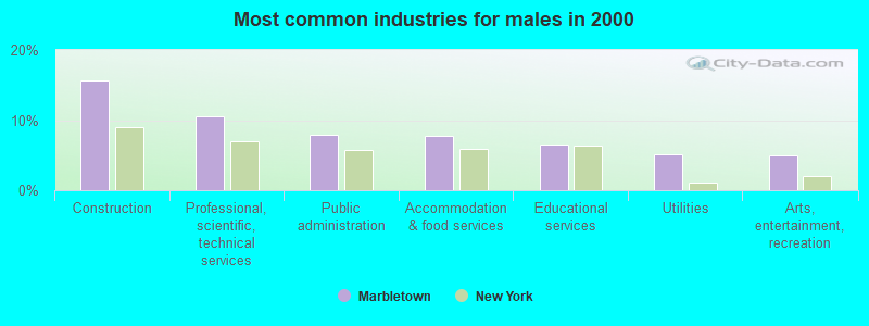
- Construction (15.7%)
- Professional, scientific, technical services (10.5%)
- Public administration (8.0%)
- Accommodation & food services (7.7%)
- Educational services (6.5%)
- Utilities (5.1%)
- Arts, entertainment, recreation (5.0%)
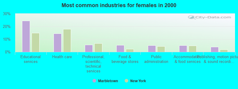
- Educational services (24.4%)
- Health care (14.5%)
- Professional, scientific, technical services (5.6%)
- Food & beverage stores (5.4%)
- Public administration (5.2%)
- Accommodation & food services (5.2%)
- Publishing, motion picture & sound recording industries (4.0%)
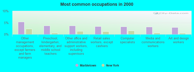
- Other management occupations, except farmers and farm managers (5.3%)
- Preschool, kindergarten, elementary, and middle school teachers (3.7%)
- Other office and administrative support workers, including supervisors (3.7%)
- Retail sales workers, except cashiers (3.4%)
- Computer specialists (3.3%)
- Media and communications workers (3.2%)
- Art and design workers (3.0%)
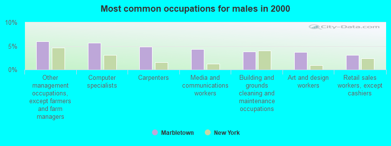
- Other management occupations, except farmers and farm managers (6.0%)
- Computer specialists (5.7%)
- Carpenters (4.8%)
- Media and communications workers (4.3%)
- Building and grounds cleaning and maintenance occupations (3.8%)
- Art and design workers (3.7%)
- Retail sales workers, except cashiers (3.1%)
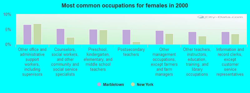
- Other office and administrative support workers, including supervisors (6.6%)
- Counselors, social workers, and other community and social service specialists (5.2%)
- Preschool, kindergarten, elementary, and middle school teachers (5.0%)
- Postsecondary teachers (4.9%)
- Other management occupations, except farmers and farm managers (4.6%)
- Other teachers, instructors, education, training, and library occupations (4.3%)
- Information and record clerks, except customer service representatives (4.2%)
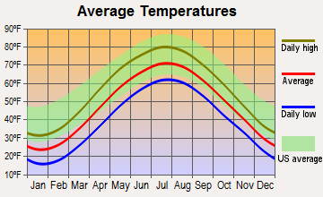
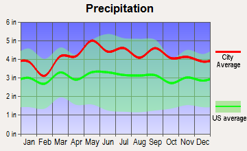
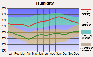
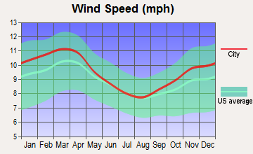
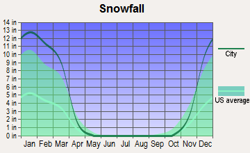
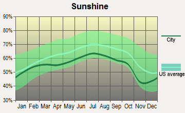
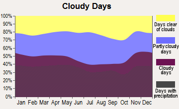
Average climate in Marbletown, New York
Based on data reported by over 4,000 weather stations
(lower is better)
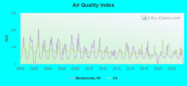
Air Quality Index (AQI) level in 2023 was 56.6. This is better than average.
| City: | 56.6 |
| U.S.: | 72.6 |
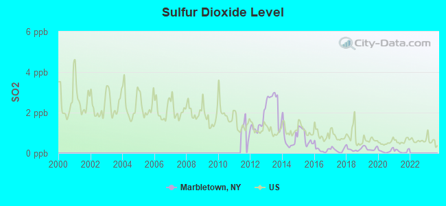
Sulfur Dioxide (SO2) [ppb] level in 2021 was 0.0919. This is significantly better than average. Closest monitor was 9.0 miles away from the city center.
| City: | 0.0919 |
| U.S.: | 1.5147 |
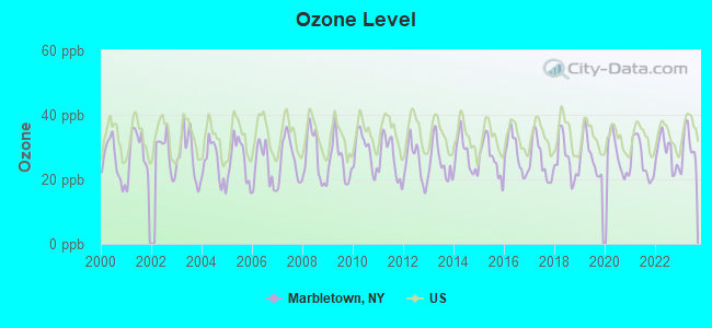
Ozone [ppb] level in 2023 was 30.1. This is about average. Closest monitor was 9.5 miles away from the city center.
| City: | 30.1 |
| U.S.: | 33.3 |
Tornado activity:
Marbletown-area historical tornado activity is above New York state average. It is 37% smaller than the overall U.S. average.
On 7/10/1989, a category F4 (max. wind speeds 207-260 mph) tornado 37.0 miles away from the Marbletown town center injured 20 people and caused between $5,000,000 and $50,000,000 in damages.
On 5/29/1995, a category F4 tornado 44.3 miles away from the town center killed 3 people and injured 24 people and caused between $5,000,000 and $50,000,000 in damages.
Earthquake activity:
Marbletown-area historical earthquake activity is significantly above New York state average. It is 67% smaller than the overall U.S. average.On 10/7/1983 at 10:18:46, a magnitude 5.3 (5.1 MB, 5.3 LG, 5.1 ML, Class: Moderate, Intensity: VI - VII) earthquake occurred 145.5 miles away from Marbletown center
On 4/20/2002 at 10:50:47, a magnitude 5.3 (5.3 ML, Depth: 3.0 mi) earthquake occurred 185.4 miles away from the city center
On 4/20/2002 at 10:50:47, a magnitude 5.2 (5.2 MB, 4.2 MS, 5.2 MW, 5.0 MW) earthquake occurred 183.5 miles away from Marbletown center
On 8/23/2011 at 17:51:04, a magnitude 5.8 (5.8 MW, Depth: 3.7 mi) earthquake occurred 338.5 miles away from the city center
On 1/16/1994 at 01:49:16, a magnitude 4.6 (4.6 MB, 4.6 LG, Depth: 3.1 mi, Class: Light, Intensity: IV - V) earthquake occurred 143.9 miles away from the city center
On 1/19/1982 at 00:14:42, a magnitude 4.7 (4.5 MB, 4.7 MD, 4.5 LG) earthquake occurred 172.8 miles away from Marbletown center
Magnitude types: regional Lg-wave magnitude (LG), body-wave magnitude (MB), duration magnitude (MD), local magnitude (ML), surface-wave magnitude (MS), moment magnitude (MW)
Natural disasters:
The number of natural disasters in Ulster County (32) is a lot greater than the US average (15).Major Disasters (Presidential) Declared: 23
Emergencies Declared: 8
Causes of natural disasters: Floods: 12, Storms: 12, Hurricanes: 6, Snowstorms: 3, Blizzards: 2, Tropical Storms: 2, Power Outage: 1, Tornado: 1, Tropical Depression: 1, Water Shortage: 1, Wind: 1, Winter Storm: 1, Other: 3 (Note: some incidents may be assigned to more than one category).
Hospitals and medical centers near Marbletown:
- GOLDEN HILL HEALTH CARE CENTER (Nursing Home, about 9 miles away; KINGSTON, NY)
- UCPA OF ULSTER COUNTY (Hospital, about 9 miles away; NEW PALTZ, NY)
- KINGSTON HOSPITAL DIALYSIS CENTER- SATELLITE (Dialysis Facility, about 10 miles away; KINGSTON, NY)
- THE MOUNTAIN VIEW NURSING AND REHAB CENTRE (Nursing Home, about 10 miles away; NEW PALTZ, NY)
- US HOMECARE KINGSTON CLOSED (Home Health Center, about 10 miles away; KINGSTON, NY)
- HEALTH ALLIANCE HOSPITAL MARY'S AVENUE CAMPUS Acute Care Hospitals (about 10 miles away; KINGSTON, NY)
- HEALTH ALLIANCE HOSPITAL BROADWAY CAMPUS Acute Care Hospitals (about 10 miles away; KINGSTON, NY)
Amtrak stations near Marbletown:
- 12 miles: RHINECLIFF-KINGSTON (RHINECLIFF, HUTTON & CHARLES STS.) . Services: ticket office, partially wheelchair accessible, enclosed waiting area, public restrooms, public payphones, vending machines, free short-term parking, free long-term parking, call for car rental service, taxi stand.
- 16 miles: POUGHKEEPSIE (41 MAIN ST.) . Services: partially wheelchair accessible, enclosed waiting area, public restrooms, public payphones, snack bar, paid short-term parking, paid long-term parking, call for car rental service, taxi stand, public transit connection.
Colleges/universities with over 2000 students nearest to Marbletown:
- Ulster County Community College (about 2 miles; Stone Ridge, NY; Full-time enrollment: 2,207)
- State University of New York at New Paltz (about 9 miles; New Paltz, NY; FT enrollment: 7,319)
- Culinary Institute of America (about 14 miles; Hyde Park, NY; FT enrollment: 3,869)
- Marist College (about 15 miles; Poughkeepsie, NY; FT enrollment: 5,536)
- Dutchess Community College (about 16 miles; Poughkeepsie, NY; FT enrollment: 6,554)
- Bard College (about 18 miles; Annandale-On-Hudson, NY; FT enrollment: 3,137)
- Vassar College (about 18 miles; Poughkeepsie, NY; FT enrollment: 2,469)
Points of interest:
Notable locations in Marbletown: DiGrazia's Tree Farm (A), Stover's Christmas Tree Farm (B), Dutchess Farm (C), Bumbleburg Farm (D), Feather Farm (E), Generation Farm (F), Harrington Farms (G), Hasbrouck Farms (H), Little Egg Farm (I), Longview Farm (J), Morning Garden Farm (K), Twilight Acres (L), High Falls Railroad Station (M), Bergemanns Farm (N), Stone Ridge Orchard (O), Stone Dock Golf Course (P), So Hi Campground (Q), John Vanderlyn Hall (R), Senate Gymnasium (S), Jacob A Hasbrouck Hall (T). Display/hide their locations on the map
Churches in Marbletown include: Clove Chapel (A), The Vly Chapel (B), Christ the King Episcopal Church (C), Lomontville Assembly of God (D), Marbletown Reformed Church (E), High Falls Community Church (F), North Marbletown Church (G), Clove Reformed Church (H), Saint Peters Church (I). Display/hide their locations on the map
Cemeteries: Benton-Bar Cemetery (1), Fairview Cemetery (2), High Falls Cemetery (3). Display/hide their locations on the map
Lakes and reservoirs: Roosa Lake (A), Stone Ridge Pond (B), Lyonsville Pond (C). Display/hide their locations on the map
Streams, rivers, and creeks: Stony Creek (A), Moosy Brook (B), Kripplebush Creek (C). Display/hide their locations on the map
Birthplace of: Leona Helmsley - Hotel Owner, Daniel Brodhead IV - General.
| This town: | 2.3 people |
| New York: | 2.6 people |
| This town: | 64.4% |
| Whole state: | 63.5% |
| This town: | 8.2% |
| Whole state: | 6.8% |
Likely homosexual households (counted as self-reported same-sex unmarried-partner households)
- Lesbian couples: 0.8% of all households
- Gay men: 1.7% of all households
| This town: | 7.3% |
| Whole state: | 14.6% |
| This town: | 4.5% |
| Whole state: | 7.4% |
People in group quarters in Marbletown in 2010:
- 62 people in workers' group living quarters and job corps centers
- 21 people in group homes intended for adults
- 4 people in other noninstitutional facilities
People in group quarters in Marbletown in 2000:
- 34 people in homes for the mentally ill
- 6 people in homes for the mentally retarded
- 5 people in agriculture workers' dormitories on farms
For population 15 years and over in Marbletown:
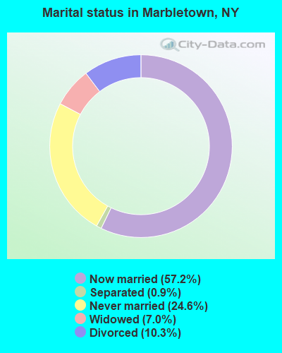
- Never married: 24.6%
- Now married: 57.2%
- Separated: 0.9%
- Widowed: 7.0%
- Divorced: 10.3%
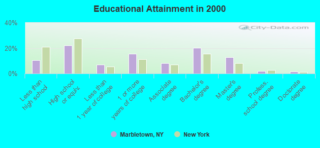
For population 25 years and over in Marbletown:
- High school or higher: 89.3%
- Bachelor's degree or higher: 36.7%
- Graduate or professional degree: 16.3%
- Unemployed: 5.1%
- Mean travel time to work (commute): 28.2 minutes
| Here: | 10.7 |
| New York average: | 14.2 |
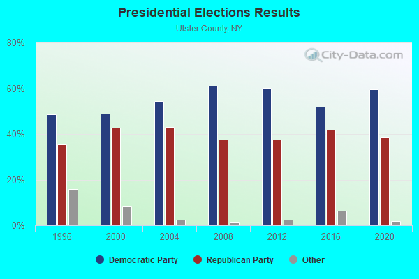
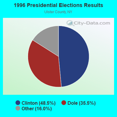
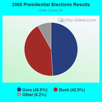
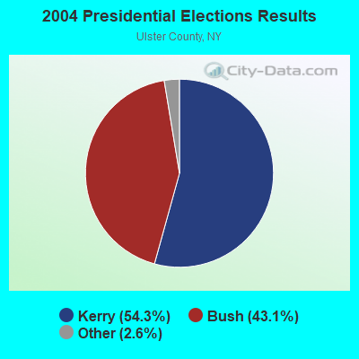
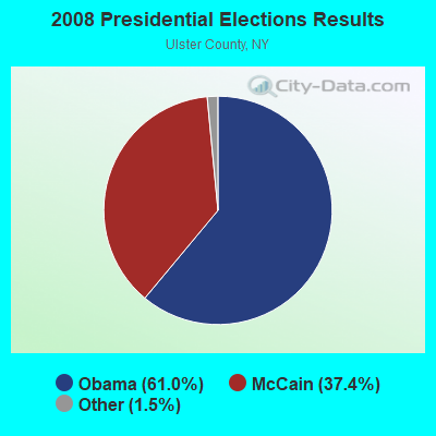

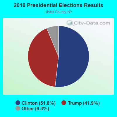
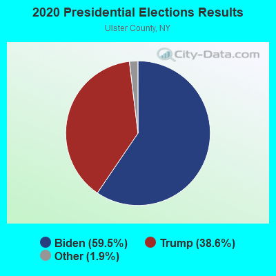
Graphs represent county-level data. Detailed 2008 Election Results
Religion statistics for Marbletown, NY (based on Ulster County data)
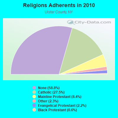
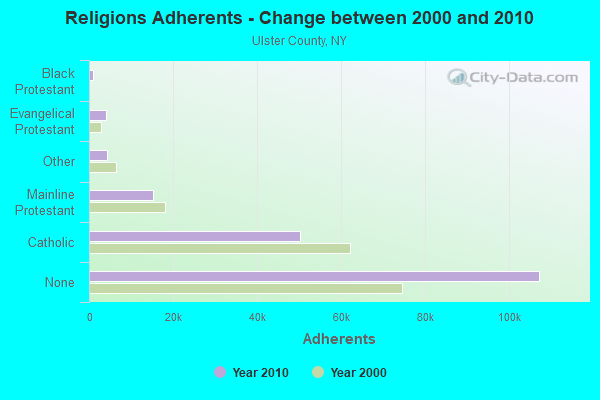
| Religion | Adherents | Congregations |
|---|---|---|
| Catholic | 50,256 | 27 |
| Mainline Protestant | 15,311 | 78 |
| Other | 4,262 | 30 |
| Evangelical Protestant | 4,104 | 42 |
| Black Protestant | 1,064 | 7 |
| Orthodox | 150 | 1 |
| None | 107,346 | - |
Food Environment Statistics:
| Ulster County: | 2.48 / 10,000 pop. |
| New York: | 4.13 / 10,000 pop. |
| Ulster County: | 0.11 / 10,000 pop. |
| New York: | 0.06 / 10,000 pop. |
| This county: | 1.27 / 10,000 pop. |
| New York: | 0.92 / 10,000 pop. |
| Here: | 3.91 / 10,000 pop. |
| New York: | 1.68 / 10,000 pop. |
| This county: | 12.61 / 10,000 pop. |
| State: | 8.82 / 10,000 pop. |
| Here: | 8.1% |
| New York: | 8.2% |
| This county: | 26.7% |
| State: | 23.8% |
| This county: | 18.9% |
| New York: | 15.6% |
Strongest AM radio stations in Marbletown:
- WGHQ (920 AM; 5 kW; KINGSTON, NY; Owner: CLEVELAND RADIO LICENSES, LLC)
- WELV (1370 AM; daytime; 5 kW; ELLENVILLE, NY; Owner: CLEAR CHANNEL BROADCASTING LICENSES, INC.)
- WGNY (1220 AM; 10 kW; NEWBURGH, NY; Owner: SUNRISE BROADCASTING LLC)
- WEOK (1390 AM; 5 kW; POUGHKEEPSIE, NY)
- WFAN (660 AM; 50 kW; NEW YORK, NY; Owner: INFINITY BROADCASTING OPERATIONS, INC.)
- WMCA (570 AM; 50 kW; NEW YORK, NY; Owner: SALEM MEDIA OF NEW YORK, LLC)
- WGY (810 AM; 50 kW; SCHENECTADY, NY; Owner: CLEAR CHANNEL BROADCASTING LICENSES, INC.)
- WABC (770 AM; 50 kW; NEW YORK, NY; Owner: WABC-AM RADIO, INC.)
- WNNZ (640 AM; 50 kW; WESTFIELD, MA; Owner: CLEAR CHANNEL BROADCASTING LICENSES, INC.)
- WOR (710 AM; 50 kW; NEW YORK, NY; Owner: BUCKLEY BROADCASTING CORPORATION)
- WCBS (880 AM; 50 kW; NEW YORK, NY; Owner: INFINITY BROADCASTING OPERATIONS, INC.)
- WTIC (1080 AM; 50 kW; HARTFORD, CT; Owner: INFINITY RADIO OPERATIONS INC.)
- WINS (1010 AM; 50 kW; NEW YORK, NY; Owner: INFINITY BROADCASTING OPERATIONS, INC.)
Strongest FM radio stations in Marbletown:
- WPDH (101.5 FM; POUGHKEEPSIE, NY; Owner: CUMULUS LICENSING CORP.)
- WFNP (88.7 FM; ROSENDALE, NY; Owner: STATE UNIVERSITY OF NEW YORK)
- WRHV (88.7 FM; POUGHKEEPSIE, NY; Owner: WMHT EDUCATIONAL TELECOMMUNICATIONS)
- WFKP (99.3 FM; ELLENVILLE, NY; Owner: CLEAR CHANNEL BROADCASTING LICENSES, INC.)
- WAMK (90.9 FM; KINGSTON, NY; Owner: W A M C)
- WFGB (89.7 FM; KINGSTON, NY; Owner: SOUND OF LIFE, INC.)
- WCZX (97.7 FM; HYDE PARK, NY; Owner: CUMULUS LICENSING CORP.)
- WRRB (96.9 FM; ARLINGTON, NY; Owner: CUMULUS LICENSING CORP.)
- WBWZ (93.3 FM; NEW PALTZ, NY; Owner: CLEVELAND RADIO LICENSES, LLC)
- WRWD-FM (107.3 FM; HIGHLAND, NY; Owner: CLEVELAND RADIO LICENSES, LLC)
- WBPM (94.3 FM; KINGSTON, NY; Owner: CONCORD MEDIA GROUP, INC.)
- W292CM (106.3 FM; POUGHKEEPSIE, NY; Owner: JOHN KATONAH)
- WRNQ (92.1 FM; POUGHKEEPSIE, NY; Owner: CLEAR CHANNEL BROADCASTING LICENSES, INC.)
- WSPK (104.7 FM; POUGHKEEPSIE, NY; Owner: 6 JOHNSON ROAD LICENSES, INC.)
- WFRH (91.7 FM; KINGSTON, NY; Owner: FAMILY STATIONS, INC.)
- WRKW (92.9 FM; SAUGERTIES, NY; Owner: CLEAR CHANNEL BROADCASTING LICENSES, INC.)
- WDST (100.1 FM; WOODSTOCK, NY; Owner: CHET-5 BROADCASTING, L.P.)
- WRIP (97.9 FM; WINDHAM, NY; Owner: RIP RADIO, LLC)
- WZAD (97.3 FM; WURTSBORO, NY; Owner: CUMULUS LICENSING CORP.)
- WLJP (89.3 FM; MONROE, NY; Owner: SOUND OF LIFE, INC.)
TV broadcast stations around Marbletown:
- WTBY (Channel 54; POUGHKEEPSIE, NY; Owner: TRINITY BROADCASTING OF NEW YORK, INC.)
- W42AE (Channel 42; POUGHKEEPSIE, NY; Owner: DUTCHESS COMMUNITY COLLEGE)
- National Bridge Inventory (NBI) Statistics
- 11Number of bridges
- 128ft / 38.7mTotal length
- $38,145,000Total costs
- 18,117Total average daily traffic
- 1,152Total average daily truck traffic
- 20,572Total future (year 2037) average daily traffic
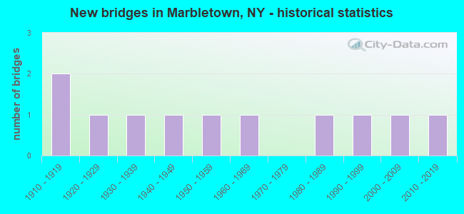
- New bridges - historical statistics
- 21910-1919
- 11920-1929
- 11930-1939
- 11940-1949
- 11950-1959
- 11960-1969
- 11980-1989
- 11990-1999
- 12000-2009
- 12010-2019
FCC Registered Broadcast Land Mobile Towers:
1- Lat: 41.886944 Lon: -74.124639, Call Sign: WQEB629,
Assigned Frequencies: 45.2000 MHz, 45.4400 MHz, Grant Date: 10/16/2015, Expiration Date: 12/21/2025, Certifier: Louis F Cardinale, Registrant: Lomontville Fire District, 2394 Hurley Mountain Rd., Kingston, NY 12401, Phone: (845) 338-9117, Fax: (845) 338-9117, Email:
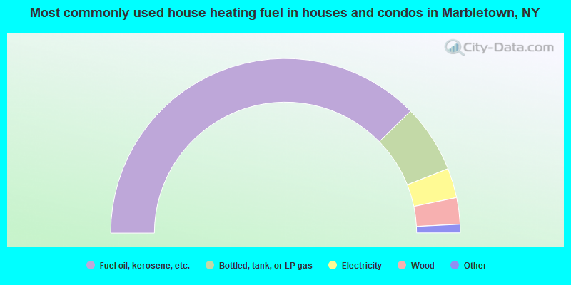
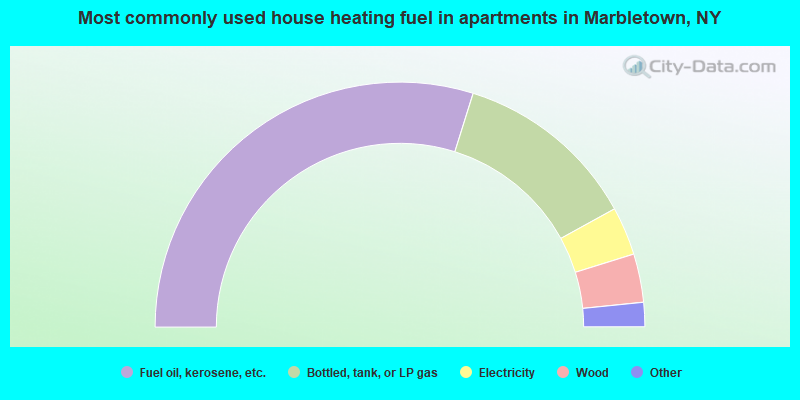
- 75.4%Fuel oil, kerosene, etc.
- 12.6%Bottled, tank, or LP gas
- 5.5%Electricity
- 4.9%Wood
- 1.2%Coal or coke
- 0.5%Utility gas
- 59.6%Fuel oil, kerosene, etc.
- 24.3%Bottled, tank, or LP gas
- 6.4%Electricity
- 6.4%Wood
- 1.6%Utility gas
- 1.6%Other fuel
Marbletown compared to New York state average:
- Unemployed percentage significantly below state average.
- Black race population percentage significantly below state average.
- Hispanic race population percentage significantly below state average.
- Median age above state average.
- Foreign-born population percentage significantly below state average.
- Renting percentage significantly below state average.
- Length of stay since moving in significantly above state average.
- Number of rooms per house significantly below state average.
- House age significantly below state average.
Marbletown on our top lists:
- #1 on the list of "Top 101 cities with largest percentage of females in industries: music stores (population 5,000+)"
- #2 on the list of "Top 101 cities with largest percentage of males in occupations: art and design workers (population 5,000+)"
- #3 on the list of "Top 101 cities with largest percentage of males in occupations: media and communication equipment workers (population 5,000+)"
- #6 on the list of "Top 101 cities with largest percentage of females in occupations: therapists (population 5,000+)"
- #6 on the list of "Top 101 cities with largest percentage of females in occupations: social scientists and related workers (population 5,000+)"
- #6 on the list of "Top 101 cities with largest percentage of females in occupations: counselors, social workers, and other community and social service specialists (population 5,000+)"
- #7 on the list of "Top 101 cities with largest percentage of females in occupations: postsecondary teachers (population 5,000+)"
- #9 on the list of "Top 101 cities with largest percentage of females in industries: furniture and home furnishings, and household appliance stores (population 5,000+)"
- #14 on the list of "Top 101 cities with largest percentage of females in industries: publishing, and motion picture and sound recording industries (population 5,000+)"
- #18 on the list of "Top 101 cities with the largest percentage of likely gay men couples (counted as self-reported male-male unmarried-partner households) (population 5,000+)"
- #29 on the list of "Top 101 cities with the largest percentage of likely homosexual households (counted as self-reported same-sex unmarried-partner households) (population 5,000+)"
- #33 on the list of "Top 101 cities with largest percentage of males in industries: retail florists (population 5,000+)"
- #34 on the list of "Top 101 cities with largest percentage of females in industries: religious, grantmaking, civic, professional, and similar organizations (population 5,000+)"
- #39 on the list of "Top 101 cities with largest percentage of males in industries: pharmacies and drug stores (population 5,000+)"
- #53 on the list of "Top 101 cities with largest percentage of males in industries: apparel (population 5,000+)"
- #59 on the list of "Top 101 cities with largest percentage of males in industries: personal and laundry services (population 5,000+)"
- #79 on the list of "Top 101 cities with largest percentage of females in industries: jewelry, luggage, and leather goods stores (population 5,000+)"
- #97 on the list of "Top 101 cities with largest percentage of females in industries: nonmetallic mineral products (population 5,000+)"
- #7 on the list of "Top 101 counties with the highest surface withdrawal of fresh water for public supply"
- #9 on the list of "Top 101 counties with the highest total withdrawal of fresh water for public supply"
- #13 on the list of "Top 101 counties with the lowest percentage of residents relocating from foreign countries between 2010 and 2011"
- #18 on the list of "Top 101 counties with the lowest number of births per 1000 residents 2007-2013"
- #44 on the list of "Top 101 counties with the lowest Sulfur Oxides Annual air pollution readings in 2012 (µg/m3)"