Ludlow, Maine
Submit your own pictures of this town and show them to the world
- OSM Map
- General Map
- Google Map
- MSN Map
Population change since 2000: +0.5%
 |
| Males: 203 | |
| Females: 201 |
| Median resident age: | 47.5 years |
| Maine median age: | 43.0 years |
Zip codes: 04730.
| Ludlow: | $42,051 |
| ME: | $69,543 |
Estimated per capita income in 2022: $25,034 (it was $12,130 in 2000)
Ludlow town income, earnings, and wages data
Estimated median house or condo value in 2022: $84,259 (it was $34,800 in 2000)
| Ludlow: | $84,259 |
| ME: | $290,600 |
Mean prices in 2022: all housing units: $179,108; detached houses: $185,023; townhouses or other attached units: $218,327; in 2-unit structures: $262,505; in 3-to-4-unit structures: $121,406; in 5-or-more-unit structures: $185,084; mobile homes: $117,009; occupied boats, rvs, vans, etc.: $12,682
Detailed information about poverty and poor residents in Ludlow, ME


- 38294.6%White alone
- 174.2%American Indian alone
- 20.5%Asian alone
- 10.2%Black alone
- 10.2%Two or more races
- 10.2%Hispanic

Races in Ludlow detailed stats: ancestries, foreign born residents, place of birth
 Recent articles from our blog. Our writers, many of them Ph.D. graduates or candidates, create easy-to-read articles on a wide variety of topics.

 | A Bunch of Subversives in Central Maine (62 replies) |
| 3bdrm cabin and mobile home on 40 acres near Houlton (13 replies) |
| Any hip, safe, attractive coastal towns with reasonable housing? (45 replies) |
| Question about Lewisberg (1 reply) |
| Haunted places in Maine? (93 replies) |
| Moving to Maine need help! (58 replies) |
Latest news from Ludlow, ME collected exclusively by city-data.com from local newspapers, TV, and radio stations
Ancestries: United States (45.3%), Irish (13.4%), English (11.9%), French (8.0%), German (7.2%), Scottish (4.0%).
Current Local Time: EST time zone
Incorporated on 03/21/1864
Elevation: 523 feet
Land area: 22.0 square miles.
Population density: 18 people per square mile (very low).
13 residents are foreign born (3.2% North America).
| This town: | 3.2% |
| Maine: | 2.9% |
| Ludlow town: | 1.9% ($650) |
| Maine: | 1.5% ($1,417) |
Nearest city with pop. 50,000+: Portland, ME  (204.9 miles , pop. 64,249).
Nearest city with pop. 200,000+: Boston, MA (306.0 miles , pop. 589,141).
Nearest city with pop. 1,000,000+: Bronx, NY (470.7 miles , pop. 1,332,650).
Nearest cities:
), ), ), )Latitude: 46.14 N, Longitude: 67.97 W
Area code commonly used in this area: 207
Single-family new house construction building permits:
- 2021: 6 buildings, average cost: $88,900
- 2020: 1 building, cost: $97,000
| Here: | 4.5% |
| Maine: | 3.4% |

- Health care (13.6%)
- Truck transportation (11.1%)
- Wood products (7.5%)
- Food & beverage stores (7.0%)
- Public administration (7.0%)
- Accommodation & food services (5.0%)
- Personal & laundry services (4.5%)
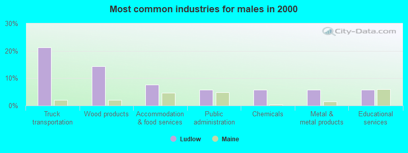
- Truck transportation (21.2%)
- Wood products (14.4%)
- Accommodation & food services (7.7%)
- Public administration (5.8%)
- Chemicals (5.8%)
- Metal & metal products (5.8%)
- Educational services (5.8%)

- Health care (26.3%)
- Food & beverage stores (9.5%)
- Public administration (8.4%)
- Personal & laundry services (7.4%)
- Administrative & support & waste management services (6.3%)
- Apparel (5.3%)
- Religious, grantmaking, civic, professional, similar organizations (5.3%)

- Driver/sales workers and truck drivers (11.1%)
- Other production occupations, including supervisors (9.0%)
- Building and grounds cleaning and maintenance occupations (8.0%)
- Nursing, psychiatric, and home health aides (6.5%)
- Other management occupations, except farmers and farm managers (5.0%)
- Other sales and related occupations, including supervisors (4.0%)
- Textile, apparel, and furnishings workers (3.5%)

- Driver/sales workers and truck drivers (21.2%)
- Other production occupations, including supervisors (11.5%)
- Building and grounds cleaning and maintenance occupations (7.7%)
- Other sales and related occupations, including supervisors (7.7%)
- Other management occupations, except farmers and farm managers (6.7%)
- Cooks and food preparation workers (4.8%)
- Carpenters (4.8%)

- Nursing, psychiatric, and home health aides (13.7%)
- Building and grounds cleaning and maintenance occupations (8.4%)
- Information and record clerks, except customer service representatives (7.4%)
- Other production occupations, including supervisors (6.3%)
- Supervisors and other personal care and service workers, except child care workers (5.3%)
- Textile, apparel, and furnishings workers (5.3%)
- Personal appearance workers (4.2%)
Average climate in Ludlow, Maine
Based on data reported by over 4,000 weather stations


(lower is better)

Air Quality Index (AQI) level in 2017 was 46.0. This is significantly better than average.
| City: | 46.0 |
| U.S.: | 72.6 |

Particulate Matter (PM2.5) [µg/m3] level in 2017 was 5.39. This is significantly better than average. There were 0 monitors within city limits.
| City: | 5.39 |
| U.S.: | 8.11 |
Earthquake activity:
Ludlow-area historical earthquake activity is above Maine state average. It is 85% smaller than the overall U.S. average.On 4/20/2002 at 10:50:47, a magnitude 5.3 (5.3 ML, Depth: 3.0 mi, Class: Moderate, Intensity: VI - VII) earthquake occurred 300.3 miles away from the city center
On 4/20/2002 at 10:50:47, a magnitude 5.2 (5.2 MB, 4.2 MS, 5.2 MW, 5.0 MW) earthquake occurred 301.9 miles away from the city center
On 7/14/2006 at 09:34:48, a magnitude 3.9 (3.9 MD, Depth: 8.6 mi, Class: Light, Intensity: II - III) earthquake occurred 61.2 miles away from Ludlow center
On 10/16/2012 at 23:12:25, a magnitude 4.7 (4.7 ML, Depth: 10.0 mi, Class: Light, Intensity: IV - V) earthquake occurred 219.7 miles away from the city center
On 10/7/1983 at 10:18:46, a magnitude 5.3 (5.1 MB, 5.3 LG, 5.1 ML) earthquake occurred 346.0 miles away from Ludlow center
On 1/19/1982 at 00:14:42, a magnitude 4.7 (4.5 MB, 4.7 MD, 4.5 LG) earthquake occurred 255.0 miles away from the city center
Magnitude types: regional Lg-wave magnitude (LG), body-wave magnitude (MB), duration magnitude (MD), local magnitude (ML), surface-wave magnitude (MS), moment magnitude (MW)
Natural disasters:
The number of natural disasters in Aroostook County (22) is greater than the US average (15).Major Disasters (Presidential) Declared: 13
Emergencies Declared: 9
Causes of natural disasters: Floods: 10, Storms: 8, Snows: 7, Heavy Rains: 2, Blizzard: 1, Hurricane: 1, Ice Storm: 1, Snowfall: 1, Snowstorm: 1, Wind: 1, Winter Storm: 1, Other: 2 (Note: some incidents may be assigned to more than one category).
Hospitals and medical centers near Ludlow:
- HOULTON REGIONAL HOSPITAL Critical Access Hospitals (about 7 miles away; HOULTON, ME)
- THE HOULTON REG PROG CARE FAC (Nursing Home, about 7 miles away; HOULTON, ME)
- FOREST SPRINGS (Hospital, about 7 miles away; HOULTON, ME)
- HARMONY (Hospital, about 7 miles away; HOULTON, ME)
- MADIGAN HOME HEALTH CARE, INC. (Home Health Center, about 7 miles away; HOULTON, ME)
- MADIGAN ESTATES (Nursing Home, about 7 miles away; HOULTON, ME)
Colleges/universities with over 2000 students nearest to Ludlow:
- University of Maine (about 93 miles; Orono, ME; Full-time enrollment: 8,931)
- Husson University (about 100 miles; Bangor, ME; FT enrollment: 2,421)
- University of Maine at Farmington (about 147 miles; Farmington, ME; FT enrollment: 2,036)
- University of Maine at Augusta (about 154 miles; Augusta, ME; FT enrollment: 3,204)
- Saint Joseph's College of Maine (about 202 miles; Standish, ME; FT enrollment: 2,010)
- Southern Maine Community College (about 205 miles; South Portland, ME; FT enrollment: 4,666)
- University of Southern Maine (about 206 miles; Portland, ME; FT enrollment: 6,647)
Points of interest:
Church in Ludlow: Baptist Church (A). Display/hide its location on the map
Cemetery: Ludlow Cemetery (1). Display/hide its location on the map
Lakes and reservoirs: Bradbury Lake (A), Lamb Brook Pond (B). Display/hide their locations on the map
Streams, rivers, and creeks: Cold Brook (A). Display/hide its location on the map
| This town: | 2.3 people |
| Maine: | 2.3 people |
| This town: | 66.7% |
| Whole state: | 62.9% |
| This town: | 10.2% |
| Whole state: | 9.4% |
Likely homosexual households (counted as self-reported same-sex unmarried-partner households)
- Lesbian couples: 0.6% of all households
- Gay men: 0.0% of all households
| This town: | 21.9% |
| Whole state: | 10.9% |
| This town: | 9.2% |
| Whole state: | 4.1% |
For population 15 years and over in Ludlow:

- Never married: 24.8%
- Now married: 53.7%
- Separated: 3.7%
- Widowed: 5.8%
- Divorced: 12.0%
For population 25 years and over in Ludlow:
- High school or higher: 83.7%
- Bachelor's degree or higher: 1.4%
- Graduate or professional degree: 0.7%
- Unemployed: 6.6%
- Mean travel time to work (commute): 17.9 minutes


| Here: | 6.7 |
| Maine average: | 11.2 |


Graphs represent county-level data. Detailed 2008 Election Results
Religion statistics for Ludlow, ME (based on Aroostook County data)


| Religion | Adherents | Congregations |
|---|---|---|
| Catholic | 22,200 | 27 |
| Mainline Protestant | 5,845 | 40 |
| Evangelical Protestant | 4,411 | 51 |
| Other | 957 | 7 |
| Orthodox | 10 | 1 |
| None | 38,447 | - |
Food Environment Statistics:
| Aroostook County: | 4.03 / 10,000 pop. |
| Maine: | 2.80 / 10,000 pop. |
| Aroostook County: | 0.14 / 10,000 pop. |
| State: | 0.14 / 10,000 pop. |
| This county: | 2.22 / 10,000 pop. |
| State: | 2.20 / 10,000 pop. |
| This county: | 7.78 / 10,000 pop. |
| Maine: | 5.75 / 10,000 pop. |
| Aroostook County: | 9.17 / 10,000 pop. |
| State: | 11.02 / 10,000 pop. |
| Here: | 11.7% |
| Maine: | 8.2% |
| This county: | 27.6% |
| Maine: | 25.0% |
Strongest AM radio stations in Ludlow:
- WREM (710 AM; daytime; 5 kW; MONTICELLO, ME; Owner: ALLAN H WEINER)
- WFST (600 AM; 5 kW; CARIBOU, ME; Owner: NORTHERN BROADCAST MINISTRIES, INC.)
- WEGP (1390 AM; 5 kW; PRESQUE ISLE, ME; Owner: DECELLES/SMITH MEDIA, INC.)
- WRKO (680 AM; 50 kW; BOSTON, MA; Owner: ENTERCOM BOSTON LICENSE, LLC)
- WZON (620 AM; 5 kW; BANGOR, ME; Owner: THE ZONE CORPORATION)
- WEEI (850 AM; 50 kW; BOSTON, MA; Owner: ENTERCOM BOSTON LICENSE, LLC)
- WCHP (760 AM; 35 kW; CHAMPLAIN, NY; Owner: CHAMPLAIN RADIO, INC.)
- WNNZ (640 AM; 50 kW; WESTFIELD, MA; Owner: CLEAR CHANNEL BROADCASTING LICENSES, INC.)
- WSKW (1160 AM; 10 kW; SKOWHEGAN, ME; Owner: MOUNTAIN WIRELESS, INCORPORATED)
- WCRN (830 AM; 50 kW; WORCESTER, MA; Owner: CARTER BROADCASTING CORPORATION)
- WABI (910 AM; 5 kW; BANGOR, ME; Owner: CLEAR CHANNEL BROADCASTING LICENSES, INC.)
- WBZ (1030 AM; 50 kW; BOSTON, MA; Owner: INFINITY BROADCASTING OPERATIONS, INC.)
- WTME (780 AM; 10 kW; RUMFORD, ME; Owner: MOUNTAIN VALLEY BROADCASTING, INC.)
Strongest FM radio stations in Ludlow:
- WHOU-FM (100.1 FM; HOULTON, ME; Owner: COUNTY COMMUNICATIONS, INC.)
- WQHR (96.1 FM; PRESQUE ISLE, ME; Owner: CITADEL BROADCASTING COMPANY)
- WOZI (101.9 FM; PRESQUE ISLE, ME; Owner: CITADEL BROADCASTING COMPANY)
- WMEM (106.1 FM; PRESQUE ISLE, ME; Owner: MAINE PUBLIC BROADCASTING CORPORATION)
- WBPW (96.9 FM; PRESQUE ISLE, ME; Owner: CITADEL BROADCASTING COMPANY)
- W274AF (102.7 FM; PRESQUE ISLE, ME; Owner: BANGOR BAPTIST CHURCH)
- National Bridge Inventory (NBI) Statistics
- 6Number of bridges
- 49ft / 15.4mTotal length
- 8,490Total average daily traffic
- 423Total average daily truck traffic
- 12,102Total future (year 2036) average daily traffic
FCC Registered Cell Phone Towers:
1 (See the full list of FCC Registered Cell Phone Towers in Ludlow)FCC Registered Antenna Towers:
14 (See the full list of FCC Registered Antenna Towers)FCC Registered Microwave Towers:
2- LUDLOW, Smyra Hill, 3.7 Km N Of I-95 And 2.4 Km N Of Us-2 (Lat: 46.161944 Lon: -68.096389), Type: Tower, Structure height: 120.3 m, Overall height: 125 m, Call Sign: WMJ800,
Assigned Frequencies: 6197.24 MHz, 6835.00 MHz, Grant Date: 02/15/2011, Expiration Date: 02/01/2021, Cancellation Date: 08/05/2015, Certifier: John T Scott Iii, Registrant: Verizon Wireless, 1120 Sanctuary Pkwy, #150 Gasa5reg, Alpharetta, GA 30009-7630, Phone: (770) 797-1070, Fax: (770) 797-1036, Email:
- Ludlow, 48 Tower Lane (Lat: 46.153694 Lon: -67.951194), Type: Ltower, Structure height: 91.1 m, Overall height: 95.7 m, Call Sign: WQUS306,
Assigned Frequencies: 10775.0 MHz, 10775.0 MHz, 10775.0 MHz, 10775.0 MHz, 10775.0 MHz, 10775.0 MHz, 10775.0 MHz, 10775.0 MHz, 10775.0 MHz, 10735.0 MHz... (+8 more), Grant Date: 09/25/2014, Expiration Date: 09/25/2024, Cancellation Date: 10/22/2020, Certifier: Jessica B Lyons, Registrant: At&t Services, Inc., 208 S. Akard Street, Room 2100, Dallas, TX 75202, Phone: (855) 699-7073, Email:
FCC Registered Amateur Radio Licenses:
3- Call Sign: KB4CVN, Licensee ID: L00142996, Grant Date: 03/06/2018, Expiration Date: 05/27/2028, Certifier: Mark A Cobbeldick, Registrant: Mark A Cobbeldick, 193 Laskey Road, Ludlow, ME 04730
- Call Sign: N4XFM, Licensee ID: L00142999, Grant Date: 09/04/2019, Expiration Date: 10/31/2029, Certifier: Debra D Cobbeldick, Registrant: Debra D Cobbeldick, 193 Laskey Road, Ludlow, ME 04730
- Call Sign: WB1AIC, Licensee ID: L00940125, Grant Date: 11/12/2004, Expiration Date: 02/10/2015, Cancellation Date: 02/11/2017, Certifier: Alan M Gillotti, Registrant: Alan M Gillotti, 171 Smyrna Town Line Rd, Ludlow, ME 04730
FAA Registered Aircraft:
2- Aircraft: CESSNA 310C (Category: Land, Engines: 2, Seats: 5, Weight: Up to 12,499 Pounds, Speed: 167 mph), Engine: CONT MOTOR I0-470 SERIES (260 HP) (Reciprocating)
N-Number: 1361Q, N1361Q, N-1361Q, Serial Number: 39017, Year manufactured: 1959, Airworthiness Date: 10/21/1959, Certificate Issue Date: 05/14/2012
Registrant (Individual): Terrance E Beals, 282 French Rd, Ludlow, ME 04730
Deregistered: Cancel Date: 12/11/1973 - Aircraft: CESSNA 150H (Category: Land, Seats: 2, Weight: Up to 12,499 Pounds, Speed: 90 mph), Engine: CONT MOTOR 0-200 SERIES (100 HP) (Reciprocating)
N-Number: 22197, N22197, N-22197, Serial Number: 15068133, Year manufactured: 1967, Airworthiness Date: 02/13/1968, Certificate Issue Date: 08/24/2010
Registrant (Individual): Terrance E Beals, 282 French Rd, Ludlow, ME 04730
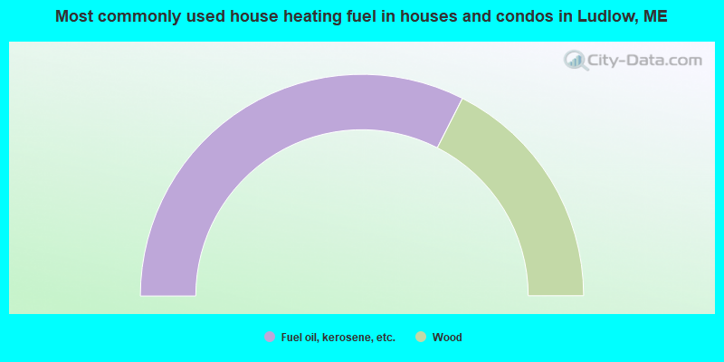
- 65.0%Fuel oil, kerosene, etc.
- 35.0%Wood
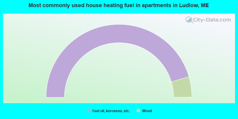
- 90.9%Fuel oil, kerosene, etc.
- 9.1%Wood
Ludlow compared to Maine state average:
- Median household income below state average.
- Median house value significantly below state average.
- Unemployed percentage below state average.
- Black race population percentage significantly below state average.
- Hispanic race population percentage significantly below state average.
- Median age above state average.
- Renting percentage significantly below state average.
- Length of stay since moving in significantly above state average.
- Number of rooms per house significantly below state average.
- House age significantly below state average.
- Percentage of population with a bachelor's degree or higher significantly below state average.